|
Belfast is currently undertaking a long-term scheme
to redirect general traffic flows out of Belfast
city centre, in order to permit a greater role for
buses, rapid transit, pedestrians and cycling.
Called Belfast on
the Move, the work is being carried out in
six phases, of which this scheme is the last (Phase
1 was completed in 2011 - see links above):
- Streets Ahead Enabling Measures Phase 1
- Sustainable Transport Enabling Measures (STEM)
- Rapid Transit Enabling Measures
- City Centre Ring Road Southern Section
- Streets Ahead Enabling Measures Phase 2
- Transforming the
City Centre Ring Road
The Belfast Inner Ring road was originally proposed
in the 1960s. The northern section (consisting of
College Avenue, Millfield, Carrick Hill, Frederick
Street and Dunbar Link) was constructed during the
1970s and 1980s. The southern section, where land
acquisition was a major problem, was never built. It
is now acknowledged that while the northern section
is highly function, it has had a very bad severance
impact on the city centre. The scale of the road can
be seen in aerial shots. This is Dunbar Link:
The Dept for Regional Development wants to reduce
this effect by reducing the scale of the road to
make it less dominant. The DRD Minister outlined in
June
2012 how this will be achieved: "My Department will
endeavour to reduce the scale of the roads system
in the northern section of the city centre ring,
including Millfield, Frederick Street and the
Dunbar Link, such that it is more appropriate to
the streetscape and does not form a barrier
between the core of the city and surrounding
residential areas." The phrase that the DRD
is using to describe the transformed road is
"boulevard", often interpreted to mean a road with
trees down the centre and two lanes on either side.
For the scheme to work, the zones of derelict land
on either side of the ring road would also need to
be developed, something which would require
significant private sector involvement.
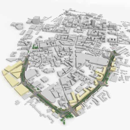
Map of how the transformed Inner Ring could look
(viewed from north with Clifton Street junction at
very bottom). Areas that could be released for
property development are shown in yellow. [DRD
image from here].
Updates
26 Jun 2012: At
this point the scheme is being publicised on the DRD
web site, and the Minister yesterday talked
about it in the Assembly
yesterday. However, as the last of the six
elements of "Belfast on the Move", it could be
some years yet before it is implemented.
|
