|
Belfast is currently undertaking a long-term scheme
to redirect general traffic flows out of Belfast
city centre, in order to permit a greater role for
buses, rapid transit, pedestrians and cycling.
Called Belfast on
the Move, the work is being carried out in
six phases, of which this scheme is the fifth:
- Streets Ahead Enabling Measures Phase 1
- Sustainable
Transport Enabling Measures (STEM)
- Rapid Transit Enabling Measures
- City Centre Ring Road Southern Section
- Streets Ahead
Enabling Measures Phase 2
- Transforming the City Centre Ring Road
At the time of writing (Jan 2012) the east-west
routes around City Hall are used by high volumes
of traffic attempting to pass through the central
area of the city to destinations outside the
central area. According
to Stephen Pollock from Roads Service, 16,000
vehicles per day pass behind City Hall, and 14,000
in front of it. Of these 60% has no destination in
the city centre.
DRD feel that this traffic is inappropriate in
such a key location, and eventually wish to remove
it. The plan is to divert all this traffic onto a
more southerly route (phase 5 of the six phases
above). Once done, this will allow the streets
around City Hall to be devoted almost entirely to
public transport.
A key aspect of the plan is to remove all traffic
(except Rapid Transit) off Donegall Square North
and Donegall Place and turn the entire area in
front of City Hall into an iconic pedestrianised
public square. All of these proposals are shown in
this DRD map, which is correct as of 2011:
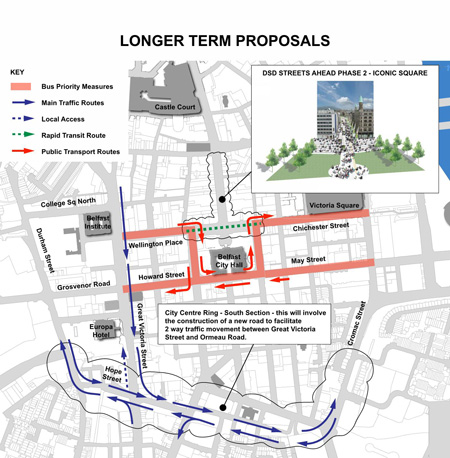
DRD Image from here.
Updates
22 Apr 2013: Although design
work has been underway now for some months,
the Social Development Minister announced
last week that this scheme has now been put
on hold. The reason for this is the
imminent development of the University of
Ulster Belfast campus on York Street and the
nearby Royal Exchange project, both of which
mean that it is more prudent to carry out a
Streets Ahead scheme north of the city centre.
The Minister said therefore "I have decided
to suspend work on Phase 2 of the Belfast:
Streets Ahead programme and have instructed
my officials to commence work on a third
phase, concentrating on the area from Royal
Avenue out to the proposed new university
campus." He also said that he "hope[s]
to be in position to revisit this project in
the future" which basically gives no
firm commitment to progressing with this
scheme. Since this scheme is intimately linked
to the City
Centre Ring Road (Southern Section), it
seems fair to conclude that that project will
not happen in the foreseeable future either.
12 Dec 2012: Apparently McAdam Design
have now come up with five options for what
could be done under this scheme. The study is
due to be completed in 2013, but there will be
an
event at the PLACE Architecture and
Built Environment Centre in Belfast on 23
January where representatives from the team
will set out what they have done so far, and
take questions. The event is free, but
requires booking (see link above). It now
seems that the City Centre Ring Road (Southern
Section), which is an associated project,
hinges on the outcome of Streets Ahead
Enabling Measures Phase 2, since the scale of
the southern section of the ring road will be
dependent on how much traffic is removed from
Donegal Square. See the page for the City
Centre Ring Road (Southern Section) for
more.
16 Jul 2012:
A consultation event took place in Belfast City
Hall on 29th June. This is the first event since
McAdam Design were appointed in March (see
below) so was more about getting opinions than
presenting proposals. The below photo was taken
before the event, and from what is visible of
the artwork, it does indeed concentrate on the
area around City Hall and the streetscapes
therein.
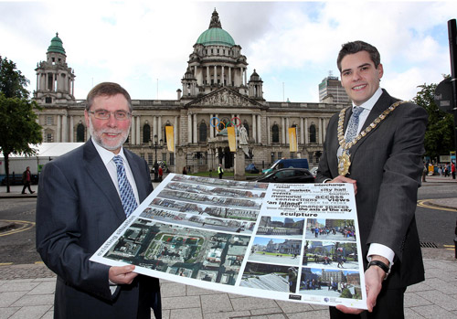
Photo: Social
Development Minister Nelson McCausland
pictured with Belfast Lord Mayor Gavin
Robinson announcing an open consultation event
to highlight development. [NI Executive]
3 Mar 2012:
The Department of Social Development issued a press
release a fortnight ago, announcing that
McAdam Design has been awarded a £0.9m contract
to develop a concept design for this scheme, ie
for developing the iconic public square in front
of City Hall. The preferred design is to be
submitted "by 2013". It suggests that the flow
of buses shown on the map above may not be set
in stone, when it says: " One of the
exciting opportunities includes getting a
better balance between buses and pedestrians
in the area, which ultimately could lead to
the removal of buses from around the city hall
or alternatively not having them continually
parked in the area but simply dropping
passengers off and collecting them."
|