|
Click here to jump straight
down to updates for this scheme.
Belfast is currently undertaking a long-term
scheme to redirect general traffic flows out of
Belfast city centre, in order to permit a
greater role for buses, rapid transit,
pedestrians and cycling. Called Belfast on the
Move, the work is being carried out in
six phases, of which this scheme is the fourth
(Phase 1 was completed in 2011 - see links
above):
- Streets Ahead Enabling Measures Phase 1
- Sustainable Transport Enabling Measures
(STEM)
- Rapid Transit Enabling Measures
- City Centre Ring
Road Southern Section
- Streets Ahead Enabling Measures Phase 2
- Transforming the City Centre Ring Road
The Belfast Inner Ring road was originally
proposed in the 1960s. The northern section
(consisting of College Avenue, Millfield, Carrick
Hill, Frederick Street and Dunbar Link) was
constructed during the 1970s and 1980s. The
southern section, where land acquisition was a
major problem, was never built. Instead, the Inner
Road has been routed along existing streets
(Cromac Street, Bruce Street, Hope Street and
Durham Street). The one gap is the stretch between
Bruce Street and Cromac Street where there is no
convenient road link.
The ultimate purpose of this scheme is to get
traffic out of the City Centre in order to provide
more space for buses/cycles/pedestrians. This will
displace a lot of traffic, so it is essential to
provide this missing link to provide an
alternative route away from City Hall. How exactly
the link will be provided is still uncertain:
Route and Design
The plan since the late 1960s has been to build
this stretch as a two-lane dual-carriageway, and
the land has been kept free of development for
around 40 years. Thus anyone who knows Ormeau
Avenue knows that the area on the south side of
the road is essentially wasteland, given over to
car parks and bare concrete. This is very
obvious in the aerial view below, which shows
the proposed route of the dual-carriageway in
red.
View in a
larger map
In recent years (ie
since 2009) there seems to have been an
acceptance within Roads Service that a
conventional dual-two lane road here might not
be acceptable (see update below in June 2012) as
it will add another level of severance to the
southern part of the city centre, the only part
of the city centre not cut off from its
hinterland by major roads. It is possible,
therefore, that TransportNI may alter the plan
to a one-way gyratory system based on the
existing streets, ie with much less new road.
The map below shows
one way that this could be achieved, although
this is not an official Roads Service proposal.
Eastbound traffic would follow the blue route,
while westbound traffic would follow the green
route.
View in a
larger map
Updates
11 Feb 2026: Not surprisingly, the
timescale for delivery of this scheme seems to
have slipped as the first elements of the BRT2 project did
not commence as indicated late last year. So I'm
going to move it back to a vaguer timescale on
this site pending a better indication of the
timescale for the initial works related to BRT2.
26 Feb 2025: Following the announcement
yesterday that elements of the BRT Phase 2
scheme are to get underway late in 2025, it
seems that Bankmore Link is one of the elements
that is going to get built with these works. I
have still not seen a dedicated design, but my
feeling is that it's most likely to similar to
the gyratory design shown above, meaning
creating a one-way system on existing city
streets, rather than an entirely new road. It
will be primarily for use by buses but also
accessible to other vehicles. Although now part
of BRT, I am keeping this as a separate page
because Bankmore Link was a standalone project
for so many years before this.
15 Sep 2021: Five years ago I commented
that the scheme was on the long finger, and was
more likely to be implemented as a gyratory
system on existing streets rather than a
conventional-dual carriageway as proposed back
in 2008 (see below). However, the recent public
consultation on Belfast Rapid Transport
Phase 2 has introduced a new possibility - that
the road could be built as part of BRT, but be
limited to rapid transit vehicles only. The map
below (click to enlarge) is from the
consultation and shows the proposed route for
the southern part of BRT2. As you can see, the
route would start on Great Victoria Street,
before crossing over to the Ormeau Road via
Bruce Street and a new 'bus only' link on the
route of the proposed Bankmore Link. This gives
the highest probability that the road will
actually be built than we have seen in some
years and, if so, it would be completed by 2027
at the earliest, albeit for buses only. It would
represent a significant change from the urban
dual-carriageway proposed in the first decade of
the twenty-first century, but this reflects
changes in policy in that time.
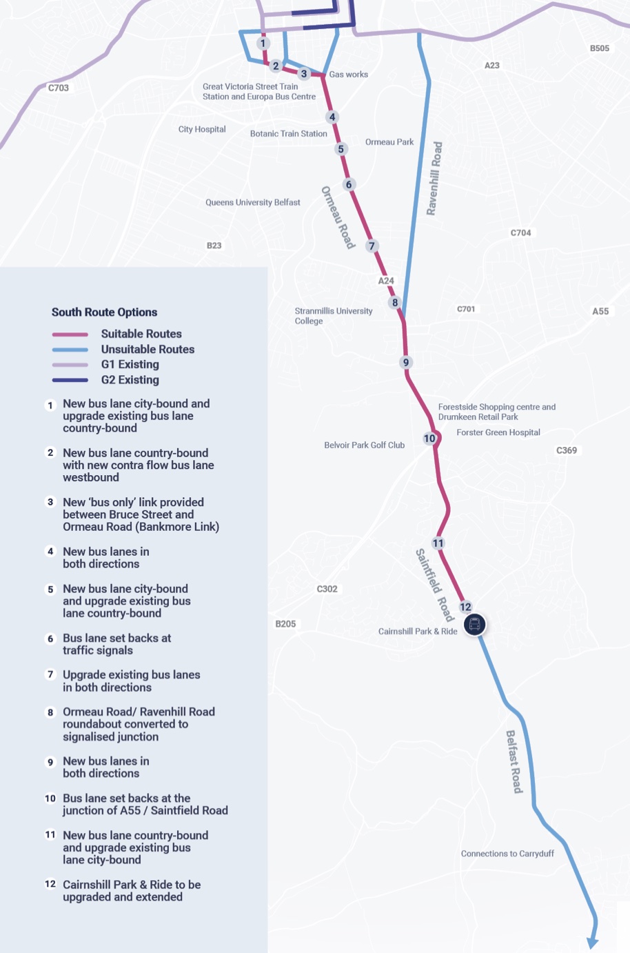
Proposed route for Belfast Rapid Transit Phase 2
as of August 2021 (click to enlarge)
24 Sep 2016: In their Spring
2016 council report to Belfast City Council,
TransportNI briefly but quite usefully mentioned
this scheme. The first point is that they refer
to it as "Shaftsbury Link" (sic), though the
description shows that it is clearly a reference
to the City Centre Ring Road south section. This
name is slightly strange as the proposed road
doesn't really go near Shaftesbury Square, but
at least the name is a little less
brutal-sounding than "City Centre Ring Road",
which may be the intention behind this label.
Although, that said, about ten years ago it was
called "Bankmore Link" which was also a nice
name. The document goes on to say "This
scheme will be much reduced in scale from that
proposed in the Belfast Metropolitan Transport
Plan (BMTP). It will focus on the needs of
public transport, pedestrians and cyclists, as
well as general traffic, and take cognisance
of potential redevelopment opportunities."
The comment about scale is in keeping with the
thinking that seems to have taken place over the
past few years as recorded in previous updates
below, and means that the new road is very
unlikely to be another urban dual-carriageway
but more likely a smaller scale road, perhaps
even a gyratory along existing streets as
discussed above. It goes on to say "An
acceptable road ‘footprint’ would identify a
number of viable and attractive sites for
redevelopment to the south of the office
district, between Sandy Row and Cromac St, and
help to remove the blight that this area has
suffered for many years." This implies
that one of the aims of the scheme would be to
finally release the land
that has sat undeveloped now for half a
century because of the road protection corridor
that has existed since the late 1960s. Some
closure on this would be most welcome for the
streetscape in this part of the city.
8 Jun 2015: It has now been over two
years since the previous update. In November
2014, Belfast City Council published their City
Centre Regeneration Strategy and
Investment Plan which sets out the
city's aspirations as the council takes on more
responsibility for planning and regeneration. It
supports the provision of the City Centre Ring
Road Southern Section (on pages 53 and 72) for a
number of reasons, including "greater network
simplicity and reduced traffic congestion
within the core area" and the removal of
"blight" from the road protection corridor that
has existed here for decades and has led to
dereliction and empty land. It does not envision
it as the conventional dual-carriageway that was
favoured by the DRD back in 2005. It says: "The
wide road reservation would allow the South
Link to be completed as a grand tree-lined
boulevard with a comfortable pedestrian
provision, potentially including a linear open
space. Development sites would be opened up
and the street could be properly framed with
buildings instead of car parks. Devoting
special attention to appropriately locating
and designing pedestrian crossing points would
enhance permeability between residential
neighbourhoods and the city centre." The
DRD itself seems to have come to a similar view,
ie that a conventional dual-carriageway would no
longer be acceptable in this location. In the
Spring report to Belfast City Council, just
published, the DRD says (page 20) "This
scheme will be much reduced in scale from that
proposed in the [2005] Belfast Metropolitan
Transport Plan (BMTP). It will focus on the
needs of public transport, pedestrians and
cyclists, as well as general traffic, and take
cognisance of potential redevelopment
opportunities. An acceptable road
‘footprint’ would identify a number of viable
and attractive sites for redevelopment to the
south of the office district, between Sandy
Row and Cromac St, and help to remove the
blight that this area has suffered for many
years." So it is safe to conclude that we
are no longer looking at the type of road
pictured in the 2008 update below, but instead
something smaller in scale, most likely a
gyratory system along the existing streets. It
is nice to see the council, those interested in
regeneration and the DRD displaying harmony on
an issue like this.
28 Apr 2013: In my previous update I
outlined how the fate of this project is
intimately tied in with the Streets
Ahead Enabling Measures Phase II scheme,
which will see all vehicles except Rapid Transit
removed from Royal Avenue and Donegall Square
North. Since the DSD Minister announced
last week that all work on that project was
being suspended indefinitely, it now seems
unlikely that there will be any need to progress
the City Centre Ring Road Southern Section in
the foreseeable future.
12 Dec 2012: It now seems that the shape
of this project will hinge on the outcome of the
related Streets
Ahead Enabling Measures Phase II scheme.
That scheme will see road space taken away from
general traffic on Donegall Square, ie around
City Hall. Since this route carries a lot of
traffic, there will have to be an alternative
route south of the city centre as existing
streets could not cope with this amount of
displaced traffic. The map above shows a current
proposal for a one-way gyratory along existing
streets on Ormeau Avenue and Bankmore Street. It
now seems that the DRD are only prepared to
implement this version of the plan if Streets
Ahead Enabling Measures Phase II does NOT remove
all traffic from behind City Hall. If it does,
then the larger-scale scheme proposed in 2008
will be back on the agenda. It is important,
therefore, that the two schemes are seen as a
pair with trade-offs between them. The folks
over at Forum
for Alternative Belfast have been working
with DRD on the proposals for this route.
26 Jun 2012: It has been over three years since the
last update, and since then it seems that Roads
Service have moved away from the design proposed
in 2008 (see previous update). The report
into the PLACE summer school in August 2011
makes these comments: "A dual carriageway
to full standards and right turning provisions
was also suggested, however this option had
little consideration for land use and
surrounding communities admitted Stephen. He
says that DRD now know that this would not be
acceptable and that a much better design would
be required for the area." It seems that
Roads Service also considered two alternatives to
the straight-forward Bankmore Link: (1) Upgrading
the existing junctions to allow more traffic
throughput along existing streets and (2) a
one-way gyratory along Ormeau Avenue (eastbound)
and Bankmore Street (westbound) as outlined on the
map above. At this point, therefore, it seems that
it is the one-way gyratory that is most likely to
be implemented, at an estimated cost of £20m. This
link is required before Phase 5 of the "Belfast on
the Move" scheme can take place, ie the removal of
all general traffic from in front of and behind
City Hall. However at this point it is in the
future and there are no firm plans to proceed.
9 Jan 2009:
Roads Service issued
a leaflet about this proposal in November
2008. The leaflet reaffirms sets out plans for
the City Centre Ring Road in general, before
commenting on this particular road link. It now
seems that the new road link will be a
dual-carriageway with two lanes in each
direction. An artists impression was included
(see below) which suggests that there will be no
dedicated left-turn filter lanes on the main
road. Although these help traffic flow, they
have been criticised for making roads in the
city centre unnecessarily wide and having poor
facilities for pedestrian crossings. Roads
Service also stress that "Completing the
scheme is considered fundamental to achieving
the public realm pedestrianisation project,
traffic reduction and capacity objectives for
the city centre". Implementation is
currently anticipated "within ten years".
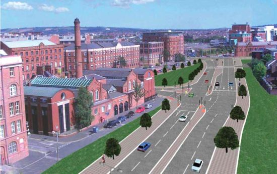
Artist's impression of the
proposed Bankmore Link as of 2008 (looking east
from the back of the former Dublin Road cinema
with the Gasworks on Ormeau Road visible in the
distance). As of 2012, this design is not likely
to be built. Taken from Roads
Service leaflet issued in November 2008.
|
