|
|
Status
|
Construction scheme
(completed) |
|
Where
|
To
construct a bus-based rapid system in
Belfast running from the city centre to
the east and west of the city, and to
Titanic Quarter |
|
Total
Length
|
In total approx
24.5 km / 15.2 miles of which:
WWAY - approx 9.8 km / 6.1 miles
EWAY - approx 8.8 km / 5.5 miles
CITI - approx 2.8 km / 1.7 miles
plus a common city centre loop -
approx 3.1 km / 1.9 miles
|
|
Dates
|
Strategic Outline Case
published 8 Apr 2008
Scheme given approval
27 Nov 2008
Public consultation ran 12 Oct 2011 - 6
Jan 2012
Outcome of consultation published - 24
Apr 2012
Outline Business Case to be published -
22 Nov 2012
First construction tender released - 23
Oct 2013
First construction tender awarded - 28
Mar 2014
First actual work
commenced 19 May 2014 (Dundonald
park-and-ride)
(changed from "late
2013" as of Dec 2013; "during 2012" as
of June 2010, and "by 2011" as of Nov
2008)
System became
operational 3 September 2018 (changed
from Autumn 2017 as of May 2014)
Final component -
Colin Transport Hub - opened 22 March
2019
Possible extension to North Belfast
- operational by 2023 (as of Feb 2016)
|
|
Cost
|
£90m as of May 2016
(changed from £98.5m as of Nov 2012;
itself changed from £150m as of Nov
2008)
|
|
Photos
|
See below
|
|
See
Also
|
Official
web site for scheme
Public
Information Leaflet - TransportNI
Rapid
Transit Enabling Measures for city
centre - on this site
|
Click
here to jump straight down to
the latest updates on this scheme.
This scheme will see the introduction of a
bus-based rapid system in Belfast known as Glider.
The initial plan, announced in November 2012, is
for three routes, all to be opened in September
2018:
- CITI
- Queen Elizabeth Bridge > Queen’s Quay
> Queen’s Road to Titanic Quarter and
returning to the city centre via Queen’s Road
> Queen’s Quay > Station Street >
Bridge End > Queen’s Bridge.
- EWAY
- City Centre > Albertbridge Road >
Upper Newtownards Road to park-and-ride
somewhere in Dundonald
- WWAY
- City Centre > Divis Street > Falls
Road > Andersonstown Road > Stewartstown
Road to a park and ride site near Dairy Farm
and/or McKinstry Road Roundabout
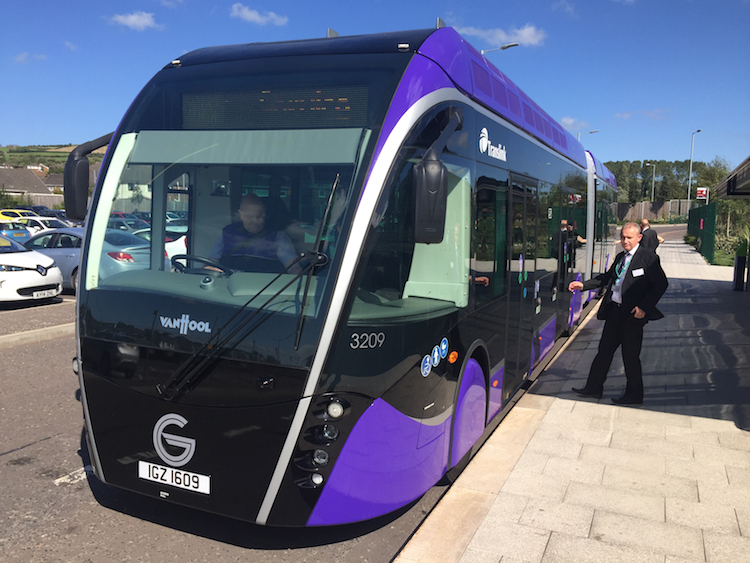
Although they will use bus lanes, the system
will operate with high-specification vehicles
with a tram-like feel (see images below)
including off-vehicle ticketing. The Regional
Development Minister said in November 2008 that
he expected the scheme to run at five-minute
intervals at peak times and attract 5.5 million
passengers per year. The scheme promises fast
journey times, an element that hinges on the use
of a dedicated rapid transit lane on almost the
entire length of each route. The ultimate
ambition seems to be to add routes running from
the city centre to the north and south. More
detailed maps of the routes can be downloaded
from this
page.
Photos
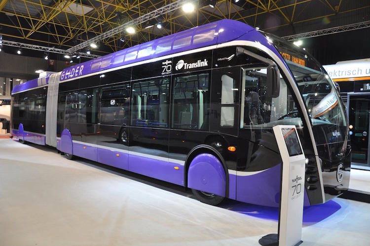
The first actual Glider vehicle on display at
the Busworld Europe exhibition in Belgium in
October 2017. [DFI]
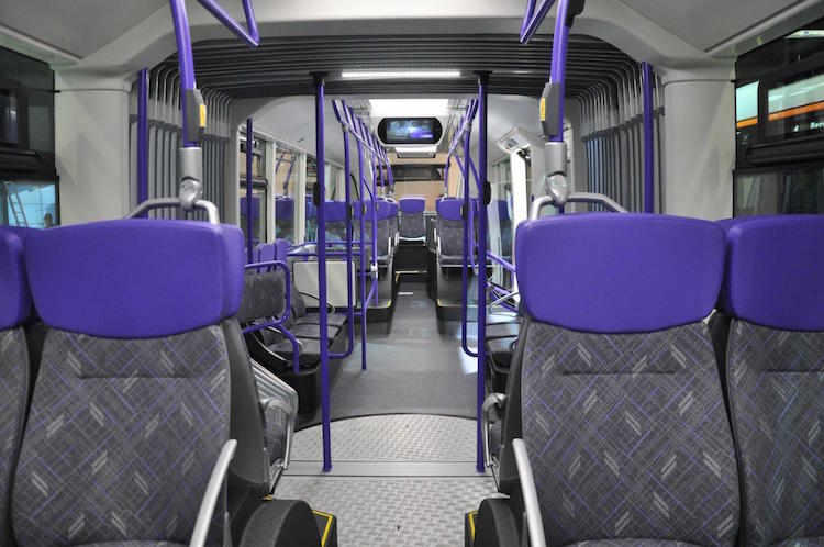
Interior of the first actual Glider vehicle on
display at the Busworld Europe exhibition in
Belgium in October 2017. Note the articulated
middle portion visible just ahead, reminiscent
of the Luas in Dublin. [DFI]
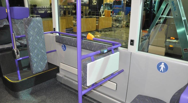
Another interior view of the first Glider
vehicle on display at the Busworld Europe
exhibition in Belgium in October 2017. [DFI]
Elements
of the Project
Project
(letters refer to the map below the
table)
|
Cost
|
Current
status
|
Start date
|
End date
|
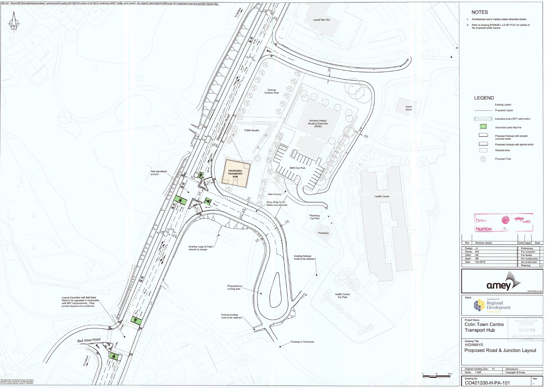
A: Transport Hub at Colin
Town Centre
|
£2.0m
|
COMPLETED
|
4 September 2017
|
22 March 2019
|
| C: Stewartstown Road (Upper
Dunmurry Lane [Michael Ferguson
Roundabout] to McKinstry Roundabout) |
£3.63m
|
COMPLETED
|
28 June 2017 (previously
June 2016)
|
June 2018
|
D:
Andersonstown/Stewartstown Road (Finaghy
Road North to Upper Dunmurry Lane [Michael
Ferguson Roundabout])
|
c£2.9m
|
COMPLETED
|
25 January 2016
(previously Mar 2015)
|
17 April 2017
|
E: Falls Road/Andersonstown
Road (Whiterock Road to Finaghy Road
North)
|
c£3.0m
|
COMPLETED |
20 February 2017 (changed
from June 2016)
|
June 2018
|
F: Falls Road
(Grosvenor Road to Whiterock Road)
|
c£3.25m
|
COMPLETED
|
8 September
2014
|
2 November 2015
(previously Jul and then Aug 2015)
|
G: Divis Street/Falls Road
(Millfield to Grosvenor Road)
|
c£2.5m
|
COMPLETED
|
12 October 2015
(previously May 2015)
|
28 February 2017
|
H: Albertbridge Road
(Castlereagh Street to Newtownards Road)
|
c£1.2m
|
COMPLETED |
29 August 2016 (previously
Apr 2016)
|
13 August 2017
|
J: Upper Newtownards Road
(Albertbridge Road to Sandown Road)
|
c£1.5m
|
COMPLETED |
15 June 2015
|
27 March 2016 (previously
Nov 2015)
|
| K: Upper Newtownards Road
(Sandown Road to Knock Road) |
c£1.43m |
COMPLETED
|
23 June 2014 |
27 March 2015 |
| L: Upper
Newtownards Road (Knock Road to Dunlady
Road, Dundonald) |
c£3.3m |
COMPLETED |
5 June 2017
|
July 2018 |
M: Dundonald Park-and-Ride
|
c£1.57m |
COMPLETED |
19 May 2014 |
1 December 2014 |
N: Titanic Quarter ("CITI"
route) along with city centre works
|
£2.31m
|
COMPLETED
|
4 September 2017
|
June 2018
|
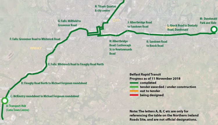
Map showing the various elements of the project
and their progress on the date shown.
Historical Background – The
Financial Case for a Bus-Based System
In April 2008, the DRD released figures that
they say shows that a bus-based system is more
econovmically viable than light rail. These
figures are shown below and were sourced from this
press release. Certainly the bus based
system is much cheaper to both build and run,
although it is likely to attract less patronage.
Most of the criticism of the decision not to
build light rail has been to do with the
international "prestige" of light rail and the
fact that it is seen as "better" by many users.
In April 2008 the DRD said "The study found
that bus based rapid transit produces positive
economic results but light rail does not. This
is because the likely numbers of passengers do
not warrant the extra cost of light rail.
There will be the option of migrating to light
rail in the future should the demand
increase."
| BUS
BASED SYSTEM |
Capital
Cost £m
|
Annual
Operating
Cost £m
|
Passengers
in Morning Peak (estimated)
|
| East Belfast Scheme |
£106
|
£0.67
|
1292
|
| West Belfast Scheme
|
£35
|
£0.41
|
608
|
| Titanic Quarter
Scheme |
£6
|
£0.36
|
1279
|
| TOTAL |
£147
|
£1.44
|
3179
|
| LIGHT
RAIL SYSTEM |
Capital
Cost £m
|
Annual
Operating
Cost £m
|
Passengers
in Morning Peak (estimated)
|
| East Belfast Scheme |
£282
|
£3.65
|
1633
|
| West Belfast Scheme
|
£217
|
£1.86
|
708
|
| Titanic Quarter
Scheme |
£91
|
£1.27
|
1464
|
| TOTAL |
£590
|
£6.78
|
3805
|
Updates
(see also summary table and map above)
24 March 2019: The final component of
Belfast Rapid Transit - Colin Transport Hub -
finally opened
to the public on Friday. Well done to all
involved. I have not yet given an assessment of
Glider to date, even though it's now been
running for six months. The main reason is that
we have not yet been given sufficiently detailed
figures to draw many conclusions. DFI figures
released in December said that there have been
"approximately 30,000 additional passenger
journeys per week" on the Glider routes when
compared with the period before Glider. These
figures combine both the new feeder services (eg
in Dundonald) with Glider, but I am told that a
feeder bus + a Glider journey are only counted
as one journey in this. The percentage split of
the journeys is Glider East - 31% and Glider
West - 30%, suggesting fairly even patronage on
both ends of the Glider route. Titanic Quarter
has a very low 2% patronage, which in fairness
does have to be set against the significant
traffic disruption caused when it was
introduced! The remaining journeys are made up
of "residual" Metro journeys, Urby journeys and
feeder bus journeys. Overall for the main Glider
route the figures sound good. However, it also
has to be said that the journey times have not
been as good as hoped for many people, with some
journeys - especially those involving feeder
buses - now taking much longer than hitherto.
Progression to Phase 2 will hinge on Phase 1
being a success, so at some point before
September we will need to see much more detailed
figures and analysis if we are to assess how
Glider has performed in practice.
11 November 2018: The scheme has now
been operational for just over two months. I
have said for a long time that we need to give
the project at least three months to bed in and
for teething issues to be resolved before making
any judgements on its success, and so I don't
intend to make any major judgements yet. There
certainly have been teething issues with the
technology (things like destination boards,
ticketing etc) and timetabling issues relating
to punctuality and ability to get on crowded
Gliders. That said, you will also find lots of
glowing reviews from travellers on social media
so some people are having a very good experience
of Glider, and a lot new people seem to be
trying it out. Some of the issues to do with not
being able to get on appear to be related to the
number of people attempting to use Glider. Some
bus enthusiasts I know have told me that Glider
would have coped fine had it just had to take
people transferring from the route 4 Metro
buses, but the fact that it struggled in its
first weeks implies that there are also a lot of
new customers which is a good sign at this
stage. There is no doubt that traffic congestion
has increased on some routes (eg the Upper
Newtownards Road especially between Stormont and
Dundonald) as was predicted, but complaints have
reduced as people have got used to the new
setup, and also appear to be diverting to
parallel routes such as Kings Road and
Craigantlet. One significant thing that
Translink have done is to re-introduce an
express bus from Dunlady park-and-ride to the
city centre (under the Urby brand, but
effectively the popular 4X resurrected). This is
a good move as it takes people travelling the
full length of the eastern G1 route off Glider,
leaving it freer for people at intermediate
stops. The Urby buses are also nicer inside than
standard Metro buses.
In other news, Colin Town Centre transport hub
- the only bit of BRT infrastructure not yet
finished - is due to be completed this month.
Translink and DFI have long talked about a
possible "phase
2" of Glider, which would see Glider
extended north to Glengormley and south along
the Ormeau Road, perhaps to Cairnshill. Such a
development is, of course, very dependent on
phase 1 being a success and so that is a key
thing to determine first. Phase 2 would cost
£70-80m and would be funded by the "City Deal"
that was recently announced for Belfast. If work
were to begin in 2019 phase 2 could be open
during 2022 in a best-case scenario.
17 September 2018: It has been a month
since the last update and there have been a lot
of developments, which I shall mention in
chronological order. Firstly, the
Titanic Quarter controversy. The bus lanes on
Queens Road and Sydenham Road in Titanic Quarter
became operational on 13 August and it was
immediately clear that there were issues. It
caused considerable tailbacks
which not only generated a lot of unwelcome
publicity right before the launch of Glider, but
caused excessive delays to other traffic
(journey times that had been 5 minutes became 30
to 60 minutes long). At one point Translink even
stopped running buses to Titanic Quarter because
the buses could not get through the traffic. DFI
tried various modifications to traffic signals,
but eventually decided to deactivate the bus
lane on 21
August. Titanic Quarter Ltd (who are
responsible for the land, rather than DFI) have
put in a planning application (ref
LA04/2018/1976/F) to widen Sydenham Road in
front of the Odyssey to three westbound lanes to
allow the bus lane to be reinstated. It is
telling that this application was submitted for
planning approval on 23 July 2018, ie a month before
the bus lane became operational. This implies
that DFI were aware that the new bus lane might
have this effect, but probably decided to go
live anyway on the principle that you "might as
well try". There is some talk that the bus lanes
were planned using traffic data from several
years ago, whereas TQ has experienced
considerable growth in that time. In any case,
I'd expect the bus lanes to come back in due
course, hopefully without these impacts.
Secondly, Glider as it is branded,
became operational on Monday 3 September. There
was a lot of fanfare in the first week with lots
of events and publicity. DFI did a good job on
making people aware of how to use Glider, with
assistants available at every stop in the first
week, videos online and a well-attended Twitter
feed for questions. There were also bun
giveaways,and everyone who used Glider on the
first day got a souvenir "first day" ticket.
Some photos taken during the stakeholders'
launch at City Hall on 31 August are below.
Thirdly, the Glider has now had two
weeks of operation. I have perviously said that
something of this scale it will inevitably have
teething issues, and that we need to give the
system two to three months before drawing
meaningful conclusions. So what I list below are
"teething issues", of which there have
unfortunately been several. It is definitely
much too soon to write the system off and so I
would again urge everyone to give it until, say,
Hallowe'en to give DFI a chance to tackle the
issues. I have been keeping an eye on Twitter
and it should be said that there has been a lot
positive said about Glider. I have seen qutie a
few people saying that they've tried it and love
it, praising the vehicle and the wifi and
charging ports and saying that they will use it
again. Even the bus lanes - outside Titanic
Quarter, and one school on the Falls Road anyway
- have not really generated much negative
comment. The main criticisms levelled so far
have been:
- the ticketing App going offline during
launch week - very unfortunate, but this was a
UK-wide issue and not Glider-specific.
- that the system is not particularly "rapid",
with journey times not dissimilar to the Metro
and in the case of people living in Dundonald
who now need to get a link bus, longer than
Metro.
- that the timetable is not being achieved,
with people reporting that they've had to wait
20 minutes or more at a stop for a Glider,
thus wiping out travel time savings.
- that in the morning rush hour the Gliders
are full to capacity shortly after commencing
their inbound journey and therefore people at
intermediate stops often aren't able to get
on.
- that there are fewer seats and therefore
more standing than on the Metro buses.
From what I can tell, then, the vehicles
themselves seem to be generally a hit, the bus
lanes are relatively OK but the key teething
issue is that the public are not finding the
service "reliable". The indications are that
there are an insufficient number of Glider
vehicles and that the timetable is overly
optimistic. DFI are, I am sure, aware of this
and will be planning ways to alleviate it.
Purchasing more Glider vehicles is one option,
though they would take a while to deliver and
this would depend on somehow finding more cash,
tricky without an Executive. Another option -
which they are already doing - is to direct more
Gliders out to the termini during the morning
peak, by using the Sydenham Bypass on the
eastern section. Failing that, a third option
would be to put some standard Metro buses on to
serve the Glider routes (they could even paint
them purple). There's no practical reason why
this could not work, due to the off-board
ticketing, but it would be a compromise since
the iconic vehicles are one of the system's
selling points.
Glider is a genuine attempt to do something
new. Given all the work that has gone into it to
date, I think the system deserves to be
persevered with in an effort to iron out these
difficulties. DFI will have a busy few weeks!
Anyway, some photos:
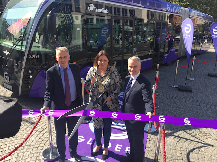
At the launch of Glider on 31 August 2018 -
David Sterling, head of the Northern Ireland
Civil Service; Lord Mayor of Belfast, Deirdre
Hargey and head of Translink, Chris Conway
[Wesley Johnston].
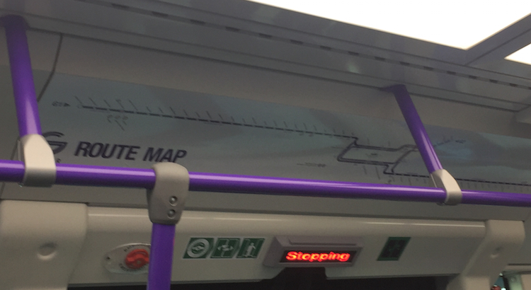
On board a Glider, the route map is very
reminscent of the London Underground or Dublin
Luas system.
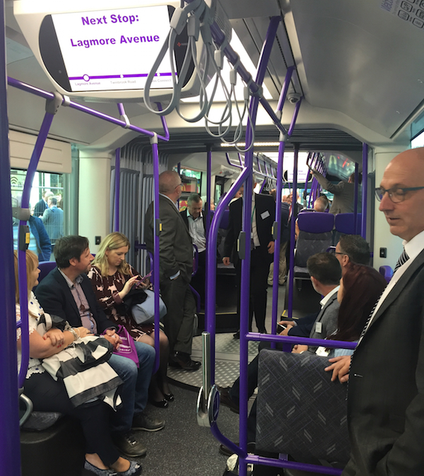
Scene on board one of the first Glider runs, 31
August 2018.
A Glider at the eastern terminus at Dunlady
Road, Dundonald, on 31 August 2018.
12 Aug 2018: The project is now in its
final weeks, and the bus lanes have finally gone
live. This was probably one of the riskiest
moments for the whole project as it was the
moment that the travelling public finally face
the reality of long, 12 hour bus lanes (they
will generally operate from 7am to 7pm Monday to
Saturday). The bus lanes on WWAY (Glider in west
Belfast) went live on 23 July, with a two week
‘one-strike’ grace period that has now ended.
The bus lanes on EWay (east Belfast) went live
on 30 July, again with a grace period that has
just ended. The bus lanes in the city centre and
Titanic Quarter will become operational
tomorrow, 13 August. The launch in west Belfast
went well, with not an excessive amount of
negative feedback and similarly in east Belfast.
However, there has been more negative feedback
about the Titanic Quarter lanes (even before
they went live) with complaints about very long
queues there, so this is one area where DFI will
probably need to do some investigation and
tweaking.
Glider is being “officially” launched at an
event on 31 August, with the service itself
becoming operation on Monday, 3 September. As
schools will go back either that day or the
Friday before, this is a second danger point for
DFI as traffic will be returning after the
summer lull. However, I would urge all
travellers to PLEASE give Glider a chance. It is
a genuine attempt to do something better with a
limited budget, and as with all major schemes it
will inevitably have teething issues and will
not be perfect. It also involves a change in
focus of transport in the city after 50 years of
focusing mostly on cars, and that too will be a
big transition. I suggest that we give the
system 12 weeks to bed-in before drawing
meaningful conclusions about it. DFI themselves
have also promised a full review after 12 months
of operation. And if you do have cause to travel
along any of the routes, give it a go and see
what you think!
One of the most common questions I have been
asked by drivers is “can I go into the bus lane
to pass someone turning right?”. As this is a
sensible question, I asked someone in DFI and
they said that enforcement would focus on people
actually driving down the bus lane, or parking
in it, but that someone who nips into the bus
lane merely to pass a vehicle turning right, and
immediately leaves again, would not be
penalised. My understanding is that provided you
clearly only enter the bus lane for that
specific purpose, and provided you are in the
bus lane for less than ten seconds, you should
be OK. However, note that I do NOT have this in
writing, so this is NOT a recommendation - make
your own judgement! And if you do nip into the
bus lane, just be mindful of
buses/cyclists/motorcyclists/taxis which might
be approaching from behind in the bus lane.
14 Jun 2018: I realised tonight that I
have not updated this page for three months,
which was not intentional! A lot has been going
on on Glider - the brand name for BRT.
The scheme is due to open in a matter of weeks
(currently the word on the street is that it
will be the second or third week of September)
and progress does seem to be matching this
timescale. On the EWAY the works have reached
Dundonald, probably the most disruptive part of
the works, creating heavy congestion at peak
times. Work in the village will continue through
July but should be completed during August.
Meanwhile on WWAY, the schemes on the Falls Road
and Stewartstown Road are both almost completed
and should be finished this month, as should the
works in the city centre and Titanic Quarter.
The Colin Town Centre Transport Hub is under
construction but will not be finished for the
launch of Glider, instead due to be completed in
November. Many road users will have spotted the
Glider halts which are almost all in place now,
and I include two photos below. They look very
well. The Glider vehicles are mostly delivered,
and many will have seen them out and about being
tested and drivers trained. It's possible they
may have to lose their nice wheel covers due to
regulations, but hopefully that will be the
limit of any issues. This video
shows you more. Since the launch of Glider will
undoubtedly create traffic disruption,
especially in the early months as it beds in,
two things are vital to its success - one is public
information, and the second is enforcement
of the bus lanes. DFI is working admirably on
the first, with a very active Glider
Twitter feed and an ambitious sequence of
public information events designed to make the
public aware of what is coming, how to use it
and the advantages that it will offer. These
events are happening now, so for the latest
information look at this
page. One thing that would be great to see
online is a map showing the location and names
of the actual Glider halts. As concerns enforcement,
my own view is that the current level of
enforcement of bus lanes in the city is very
inadequate, with the white bus lane car doing a
good job but is limited by being only one
vehicle. Journey time is critical to the success
of Glider, and so I think ramping up enforcement
significantly is critical to its success and
acceptance by the travelling public. Finally, I
would say that "yes, it's a bus" as I am
regularly told. Nor is it perfect. But it's
still the most serious and ambitious attempt to
improve public transport in the city since World
War Two and I really do think it deserves to be
given a decent chance. I would encourage people,
therefore, not to be too cynical about the whole
thing until we've given it a few months.
</soapbox>
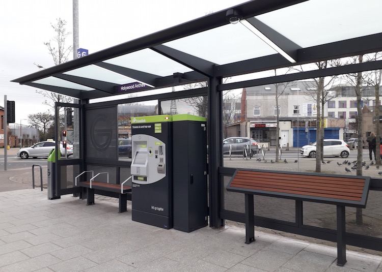
Typical Glider halt at Holywood Arches,
featuring the off-vehicle ticket machine that
will speed boarding. [DFI from this
tweet]
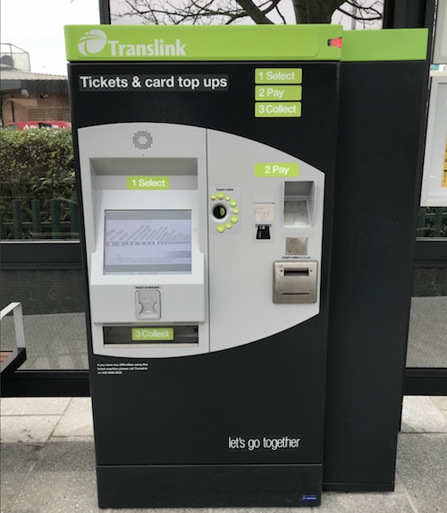
Close-up of the Glider ticket machine. It is
rather reminiscent of the Luas ticketing system
in Dublin. [DFI from this
tweet] 22 Mar 2018: The scheme is now just 6
months away from opening, and the final pieces
of the jigsaw do seem to be falling into place.
DFI
say that the 103 halts needed for the
scheme are being built at a rate of 3 per week
since at least the end of 2017. Four components
of the bus lanes are still under construction,
with all due to be completed by June or July,
plus the Colin Town Centre Hub whose completion
date has been pushed back slightly to August
2018. The two photographs below were taken on
the Upper Newtownards Road section of BRT (the
focus on this stretch is because it is the only
bit that I drive regularly!). On this stretch
works began at the A55 Outer Ring junction in
June last year and have been working their way
east, and have recently reached the Ulster
Hospital. Presumably the next 3 months will see
work adance through Dundonald village to the
terminus at the Dunlady Road park-and-ride. More
substantial work to build dedicated right-turn
lanes at Stoney Road and Comber Road is ongoing,
but the latter is causing considerable delays as
the existing road has been reduced to one lane,
meaning that even a single vehicle waiting to
turn right blocks the entire eastbound A20. The
situation would greatly benefit from a basic
timing adjustment to give a longer right-turn
sequence to countrybound traffic in the evening
rush hour. Hopefully this situation will not
remain for long. Legal orders to bring the new
bus lanes into effect still need to be passed,
but as of two weeks ago clamp-and-tow finally
came into effect. So from now on, a vehicle
parked in a Clearway or bus lane risks having it
towed away and clamped.
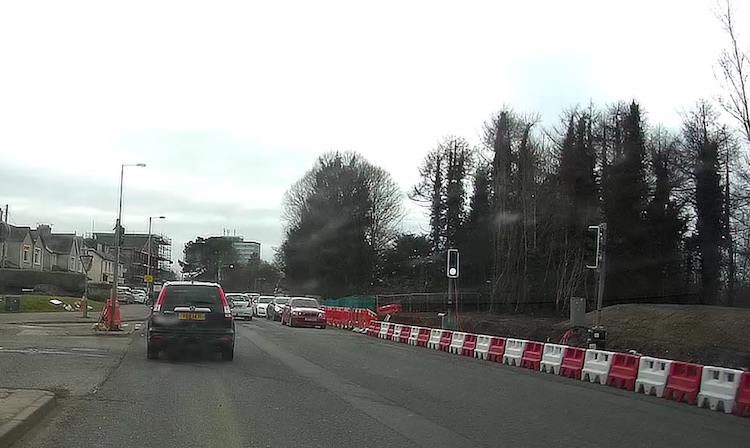
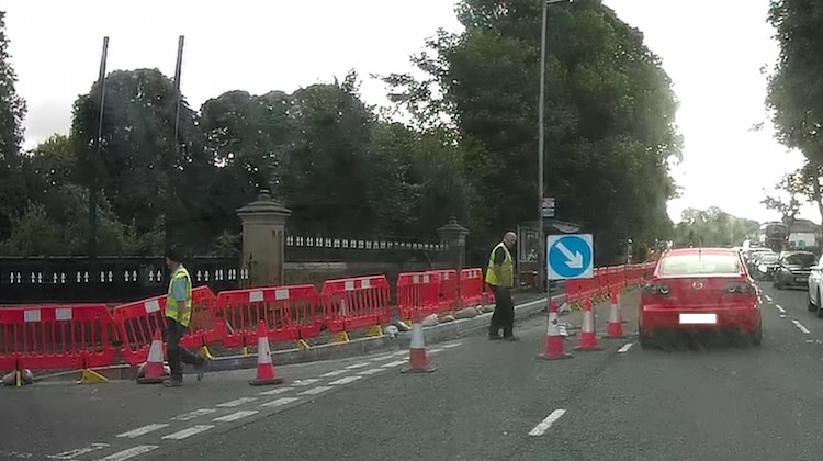
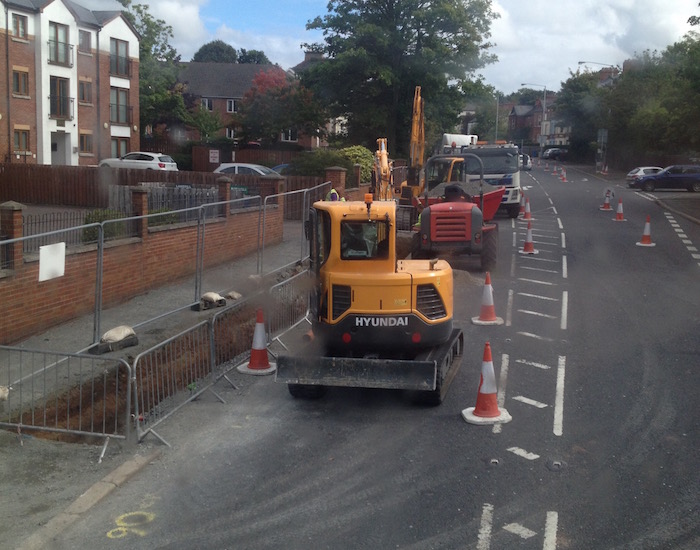
Belfast Rapid Transit works on the Upper
Newtownards Road at the Comber Road junction,
viewed citybound, where a right-turn pocket is
being created. At the mintue it is leading to
lengthy delays in the rush hour. 13 Mar 2018.
[Wesley Johnston]
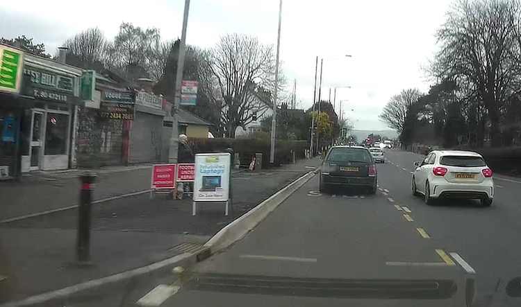
View west (citybound) along a completed stretch
of the Upper Newtownards Road approaching the
Outer Ring. The widening works have been
completed here and the road resurfaced. The kerb
on the left is interesting - this appears to be
a site for a future halt (which hasn't yet been
built) but the higher kerb shown seems to be
intended to make it easier to get onto the
Glider vehicles. 13 Mar 2018. [Wesley Johnston] 5 Nov 2017: On 19 October DFI unveiled
the first of the Rapid Transit vehicles that
will be used on BRT when it opens to the public
in just ten months' time. I have included
several of these photos further up this page.
Most notably, it has been revealed that the
vehicles will be branded "Glider",
presumably instead of the working title "Belfast
Rapid Transit". So this means that you will talk
about "getting the Glider into the city"
rather than "getting the BRT", which
rolls off the tongue more easily. There has been
some talk on social media about why DFI seem so
keen not to call the vehicles "buses" when that
is essentially what they are. I think the reason
is that Glider legitimally sits between the
categories 'bus' and 'tram', having features of
both. It is a 'bus' in the sense that it is a
road vehicle with tyres operating on asphalt
roads. However, it operates more like a 'tram'
in terms of the level of service - fewer stops
of a higher-standard and off-board ticketing are
more typically associated with trams. DFI are
keen to ensure the public understand that this
is a higher level of service than you get on a
typical bus, and are hence avoiding the term – I
think there are sound reasons for doing so. The
press release gives more information on the
features: "The 18 metre articulated Glider
vehicles will use the latest diesel-electric
hybrid engine technology delivering a smoother
take off from halts, lower noise, reduced
vibration and lower emissions. Each Glider
vehicle will carry 105 passengers and will
feature real time passenger information, audio
next stop and destination announcements, CCTV,
free Wi-Fi, USB charging facilities and air
conditioning". In other
news, construction of the Glider halts is now
underway - I regularly drive on the Upper
Newtownards Road and have seen a number underway
or completed. The same may be true on other
parts of the route.
5 Oct 2017: It has been five months
since I updated this page, and there is a lot to
report, most significantly the fact that every
element of the road infrastructure for Belfast
Rapid Transit is now either complete or under
construction. Starting at the western end, the
new £2m Colin Town Centre Transport Hub
(A on the map above), which will be the
effective western terminus of BRT, got underway
on 4 September and is scheduled to be completed
by July 2018. The official sod-cutting ceremony
took place on 12 September 2017. Next, the
construction contract for the Stewartstown
Road (Upper Dunmurry Lane [Michael Ferguson
Roundabout] to McKinstry Roundabout)
element (C on the map) was awarded on 22 May
2017 to John McQuillan Contracts at a cost of
£3.63m. Work got underway on 28 June and is due
to be completed in June 2018. Work on the Falls
Road/Andersonstown Road (Whiterock Road to
Finaghy Road North) element of the scheme
(E on the map above) continues and is also due
to be completed in June 2018. Work was carried
out over the summer (from 1 July to late August)
to replace Kennedy Way roundabout on the route
of BRT with a signalised crossroads. There was
some negative
publicity concerning the significant
traffic congestion that resulted and this seems
to be subject to ongoing tweaking by DFI as the
junction 'beds in'. At the conclusion of the
scheme the emphasis was on improved safety for
cyclists and pedestrians, which is likely to be
true since it controls these movements much more
tightly. However I am certain that the overall
rationale is to faciliate Rapid Transit vehicles
which would find it difficult to negotiate such
a busy roundabout (the initial
press release explicity saying that the
work was being carried out as part of Belfast
Rapid Transit). Next, the contract for the
£2.31m City Centre and Titanic
Quarter (CITI) section of the
scheme (N on the map above) was awarded on 1
August 2017 to Gibson (Banbridge) Ltd and work
began on 4 September, with completion also due
in June 2018. Next, work on the Albertbridge
Road (Castlereagh Street to Newtownards Road)
stretch of BRT (H on the map above) was
completed on 13 August 2017 and the bus lane has
come
into operation. Finally, work got underway
on the Upper Newtownards Road (Knock Road to
Dunlady Road, Dundonald) section (L on the
map) on 5 June 2017 and is due to be completed
in July 2018. This is possibly the most
noteworthy stretch from the point of iew of road
planning since it is the only part of the BRT
system that runs along a strategic road (these
are roads considered important for long-distance
traffic). As I use this section regularly (on a
strategic journey!) I include two photos below
showing the nature of the works here over the
past couple of months. All told, the scheme
seems to be on schedule for opening in September
2018 as planned, though there is little room for
slippage in these timescales.
BRT works underway on Upper Newtownards Road
looking east from near Cabin Hill on 24 August
2017. The nature of the works shown here -
relocating kerb lines and drains, often by small
distances - are typical of what BRT
infrastructure works have involved. [Wesley
Johnston].
View west along the same stretch of the Upper
Newtownards Road - with the A55 junction visible
in the distance - on 1 September 2017 showing a
completed kerb relocation. You can see from the
existing white "Give Way" markings that the kerb
here has been moved about half a metre back.
This is to safely accommodate the width of BRT
vehicles. Note also the drains inset in the
kerb, designed to give a less bumpy ride than
grilles on the road [Wesley Johnston].
16 May 2017: The scheme is now entering
its final phase as the last bus lane element
went out
to tender on 27 April (the city centre
and Titanic Quarter, or "CITI", section).
This element has an estimated value of £1.8m and
a closing date for tenders of 5 June.
Construction is estimated to get underway in the
summer with a construction duration of 9 months.
Meanwhile, the tender for construction of the Upper
Newtownards Road (Knock Road to Dunlady Road,
Dundonald) section was awarded to John
McQuillan (Contracts) Ltd on 9 May -
congratulations to them. Construction is due to
begin next month and should be complete by
summer 2018. The Stewartstown Road (Upper
Dunmurry Lane [Michael Ferguson Roundabout] to
McKinstry Roundabout) section is still out
to tender, though the timescale has slipped -
completion is now stated as "summer" 2018,
rather than "spring" 2018. The same slippage is
also true of the Colin Town Centre Hub,
now scheduled for completion in "summer" 2018.
The whole system is due to open in September
2018 so we can't really afford any further
slippages in these final elements. In other
news, a trial that permitted all taxis to use
Belfast Rapid Transit bus lanes for three months
ended
on 14 May 2017. DFI are now asking the public
for their view of the trials. Personally, I
struggle with the logic of the idea given that
TransportNI's own research shows that this would
be harmful to buses, Rapid Transit and cyclists.
Not to mention that it was specifically to
encourage use of these forms of transport that
the bus lanes were introduced in the first
place, and that the success of Belfast Rapid
Transit will hinge on how rapidly the BRT
vehicles can traverse the bus lanes. Anyhow,
whether you are for or against, you can access
the survey here.
14 Apr 2017: The table
of sections and route map
above have both been updated. The Falls
Road (Grosvenor Road to Whiterock Road) element
of BRT was completed on 28 February 2017,
becoming the fourth stretch to reach that
milestone. Next, on the Andersonstown/
Stewartstown Road (Finaghy Road North to Upper
Dunmurry Lane [Michael Ferguson Roundabout]) section
the new bus lane, which is citybound only, will
come into force on Monday 17 April. I have
tentatively marked this stretch as completed too
on the basis of this opening, making it the
fifth to be completed. Meanwhile, a public
consultation into the Titanic Quarter and city
centre works (CITI route) took place in
early March. According to the DFI
web site the tender for this element is
due to be advertised in April 2017 (so, anytime)
at a cost of approx £1.8m. Two other elements
are currently out to tender - the Upper
Newtownards Road (Knock Road to Dunlady Road,
Dundonald) section and the Stewartstown
Road (Upper Dunmurry Lane [Michael Ferguson
Roundabout] to McKinstry Roundabout)
section. In both cases the deadlines for
submissions has passed, so the next step will be
the appointment of a contractor with work likely
to get underway rapidly after that.
22 Feb 2017: The constuction
tender for the Upper Newtownards Road
(Knock Road to Dunlady Road, Dundonald)
scheme was advertised on 1 Feb 2017, with an
estimated value of £3.3m and a duration of 15
months. Tendering closes on 6 March. Work is due
to get underway in "Spring" 2017 with completion
due in "Spring 2018" (though that doesn't seem
to square with the contract duration of 15
months). And the construction tender for the Stewartstown
Road (Upper Dunmurry Lane [Michael Ferguson
Roundabout] to McKinstry Roundabout)
section was advertised on on 10 Feb 2017, with
an estimated value of £3.6m and a duration of 11
months. Tendering closes on 21 March. Work on
this scheme is also due to get underway in
"Spring" 2017 with completion due in "Spring
2018". These are the final two stretches of the
main East-West route (EWAY and WWAY) as you can
see from the progress map further up. The last
elements are the Colin Town Centre Hub,
which is due to get underway in "Spring" 2017,
and the Titanic Quarter (CITI) route,
which is now confirmed to include the City
Centre works, due to get underway in
Summer 2017. So all elements would appear to be
on course for completion in time for opening in
September 2018 as planned. Last month
TransportNI launched a public
consultation into their proposal to change
the hours of the bus lanes along the BRT route
to 12 hours per day (7am-7pm) when BRT launches
next year. This has always been the plan, and I
can't see that changing, so I think it's more
that TransportNI want to ensure that everyone
has a chance to raise issues so that they can,
if possible, be addressed head of time. The
Minister said "my Department will be carrying
out local engagement to identify concerns and
develop final proposals to address these, as
far as reasonably practicable". The
Consultation will apparently take place on a
rolling basis over the comign months and be
initiated by letter drops to homes and
businesses on the route itself.
15 Dec 2016: The construction contract
for the Falls Road/Andersonstown Road
(Whiterock Road to Finaghy Road North)
element of the scheme (labelled "E" on the map
above) was awarded to Northstone (NI) Limited
Materials Divison on 5 December -
congratulations to them. Work is scheduled to
begin after the break in Janaury. Meanwhile work
continues on the Divis Street/Falls Road
(Millfield to Grosvenor Road) scheme which
began in October 2015. The completion date for
it seems to have slipped yet again, this time to
February 2017, about 6 months behind the
original schedule. The tender for the
construction of the Upper Newtownards Road
(Knock Road to Dunlady Road, Dundonald)
scheme is still in the DFI's "future tenders"
list with an estimated release date of December
2016 - though time is running out for that to
happen. Work is due to get underway in the
spring. Provided it goes out to tender soon that
still seems achievable (the tender process for
BRT elements seems to be taking about 3 months).
I have updated the map above to show the current
state of affairs - you can see from this that
the scheme is starting to look quite advanced.
6 Nov 2016: A public information event
was held on Thursday 3 Nov into the Stewartstown
Road (Upper Dunmurry Lane [Michael Ferguson
Roundabout] to McKinstry Roundabout)
section and the associated Transport Hub at
Colin Town Centre (labelled "C" and "A" on the
map and table above). A second event on the same
scheme will be held tomorrow (Monday 7 November)
between 1:00 pm and 8:00 pm at
the Colin Glen Library, in the Dairy Farm
Centre. Work on these elements is due to get
underway in spring 2017. Meanwhile, work
continues on three stretches as outlined in the
table above, though it seems that the schedule
has slipped again for the Divis Street/Falls
Road (Millfield to Grosvenor Road) scheme
which began in October 2015. It had originally
been due to be compled in August 2016, but in
August this was revised to November, and the DFI
web site has now revised it again to
January 2017, which is now about 5 months behind
the original schedule. It's not clear what
issues have caused these delays. The tender for
construction of the Upper Newtownards Road
(Knock Road to Dunlady Road, Dundonald)
scheme has now appeared in the DFI's "future
tenders" list with an estimated release date of
November 2016, so I'd expect this to be
advertised within the next few weeks.
Construction is due to get underway in the
spring and last for one year.
2 Oct 2016: I attended last week's
public information event into the section of
Belfast Rapid Transit on the Upper
Newtownards Road (Knock Road to Dunlady Road,
Dundonald) scheme ("L" on the map above).
This section deserves to be treated as different
from all the others because it is the only
section that is being built on a "strategic"
road. The "strategic" road network is the small
number of routes that are considered vital to
Northern Ireland as a region, rather than
serving mostly local traffic. So while the Upper
Newtownards Road does carry commuters, it also
carries a high percentage of strategic traffic
that cannot realistically switch to BRT, eg a
vehicle travelling from the Ards Peninsula to
Belfast International Airport. At the event the
person I spoke to said that they were very aware
of this fact and hence their design included
features that were designed to ensure that the
impact on general traffic will not be as severe
as it could be (though there will be a
significant impact). In general one lane each
way will be a bus lane leaving one lane for
general traffic, but at critical junctions the
bus lane will end to allow two lanes for general
traffic. The most obvious example is the
critical junction with the A55 Outer Ring
(basically, where two strategic roads meet).
Travelling west into the city the bus lane will
end at Thornhill
Park/Castlehill Road, just under half a
mile from the Outer Ring allowing two lanes for
general traffic approaching the Outer Ring. This
will, of course, impact the speed of BRT, but
realistically having a bus lane all the way to
the Outer Ring would result in gridlock for
strategic as well as commuter traffic, which
would be an excessive impact on the travelling
public compared to the benefits that would be
gained.
Two other very notable and welcome elements of
the plan are the provision of dedicated
right-turn lanes at two troublesome
junctions - the Stoney
Road junction (leading into the Stormont
estate) and the Comber
Road junction (at The Elk), in both cases
right-turning vehicles restrict flows on the
current road. The images below show how these
two junctions would look under current plans.
While the planners were keen to stress that
these designs are "first iterations" (meaning
they could change) another point is that there
no longer seems to be a plan to ban right-turns
in Dundonald village itself, as was once
suggested. When I raised the issue of how the
road would flow if the only lane that general
traffic could use was blocked by a right-turning
vehicle, the reply was that the planners would
use a "common sense" approach to enforcement of
the bus lane, which I would take to mean that
nipping into the bus lane to pass a
right-turning vehicle would be tolerated.
However the exact meaning of that policy is
something that would probably need to be stated
more explicitly once the scheme is completed to
avoid any misunderstandings, especially since
bus lane cameras are planned at a few locations.
Finally, in other news, a BRT rep told me that
the BRT works in Titanic Quarter (called
the "CITI" route, "N" on the map above) will
begin in spring or summer 2017 and be completed
in spring 2018. And also that a public
information event into the Stewartstown Road
(Upper Dunmurry Lane [Michael Ferguson
Roundabout] to McKinstry Roundabout)
scheme ("C" on the map above) will be held in
either October or November.
The Stoney Road/Upper Newtownards Road junction
as it would look under 2016 plans for BRT. The
blue shading shows road widening, which allows a
right-turn lane for traffic entering Stoney
Road. Note that the bus lane stops before the
junction and resumes afterwards. This is a
tactic to increase throughput of the junction. This
is how the Stoney Road junction looks today
[TransportNI].
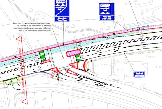
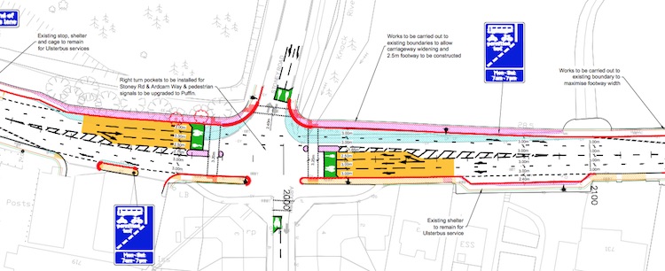
The Comber Road/Upper Newtownards Road junction
as it would look under 2016 plans for BRT. The
blue shading shows road widening, which allows a
right-turn lane for traffic entering Comber
Road. Again, the bus lane stops before the
junction and resumes after it. This
is how the Comber Road junction looks today
[TransportNI]. 14 Sep 2016: Work on the Albertbridge
Road (Castlereagh Street to Newtownards Road)
stretch of BRT (labelled "H" on the map above)
got underway on 29 August and will continue
until "summer 2017". Meanwhile, the tender for
the Falls Road/Andersonstown Road (Whiterock
Road to Finaghy Road North) scheme
(labelled "E" on the map above) has finally been
advertised
with a closing date of 18 October and an
estimated cost of £3m and a contract duration of
13 months. I have updated the map and table
above to reflect these changes. This leaves just
two main sections unbuilt, namely the Stewartstown
Road (Upper Dunmurry Lane [Michael Ferguson
Roundabout] to McKinstry Roundabout)
scheme ("C" on the map above) and the Upper
Newtownards Road (Knock Road to Dunlady Road,
Dundonald) scheme ("L" on the map above).
The latter of these, in Dundonald, is due to get
underway in early 2017 and TransportNI are
holding public information events in the
terminal building at Dundonald Park and Ride on
Thursday 22nd September 2016 between 11.00am and
8.00pm and in Dundonald Library on Friday 23rd
September 2016 between 10.15am and 2.00pm. All
those who use this route would be recommended to
attend. This is the only part of BRT that runs
along a strategic road (important roads of
regional significance) and so this element is
the one most likely to have an impact on
longer-distance traffic. Finally, this
DfI press release last week confirms that
planning permission has been granted for the Colin
Town Centre Transport Hub ("A" on the map
above), but implies that construction is still a
while away. Work will also need to take place on
the halts along the route and in the city
centre, and in Titanic Quarter. To date there is
no sign of this work getting underway.
9 Aug 2016: The tender for construction
of the Albertbridge Road (Castlereagh Street
to Newtownards Road) stretch of BRT
(labelled "H" on the map above) was awarded
to John McQuillan (Contracts) Ltd on 5 August -
congratulations to them. Work is due to get
underway in September. Like other elements of
BRT, this scheme is rather "bitty", by which I
mean it involves tidying up lots of small things
like the positions of drains, relocating kerbs
by a few feet, adjusting signage and signals and
suchlike. Individually most of these would be
considered fairly minor works, but along the
whole length of BRT they add up to a substantial
amount of work. Work will also include
resurfacing the road and footway along most of
the stretch, replacing all the street lights
with funky new LED lights, upgrading all the
pedestrian crossings (probably to "Puffin"
crossings where the Green Man is on the same
side of the road as the button, rather than on
the opposite side) and improving the traffic
signals at the Templemore Avenue, Connswater
Link and Newtownards Road junctions. Meanwhile,
the timescale for the Falls
Road/Andersonstown Road (Whiterock Road to
Finaghy Road North) scheme (labelled "E"
on the map above) has slipped yet again. In the
previous update in May I noted that its start
date had been pushed back from June to "autumn"
2016. However the DfI
web site has been changed, now saying
"January 2018". Interestingly, the completion
date has not changed, and remains
"Spring 2018", which is either a mistake or else
they are hoping to speed up the construction
phase. This may be necessary, since the whole
system is meant to launch in September 2018 -
for this reason I hope we do not see too many
other schemes with completion dates running into
mid 2018. Next, there is the Divis
Street/Falls Road (Millfield to Grosvenor
Road) scheme (labelled "G" on the map
above) which has been under construction since
October 2015. It had been due to be completed in
August 2016, but I see now that the DFI
web site has been updated to revise this
to "November 2016", a three month delay. Next,
work on the Andersonstown/Stewartstown
Road (Finaghy Road North to Upper Dunmurry
Lane [Michael Ferguson Roundabout]) scheme
(labelled "D" on the map above) is still ongoing
and so far there do not seem to be any changes
to the scheduled completion of Spring 2017.
Finally, the Upper Newtownards Road
(Albertbridge Road to Sandown Road) scheme
(labelled "J" on the map above) was completed
successfully on 27 March 2016. All told, it is
taking me a lot of time and effort to track the
progress on the various stages of this scheme
so, for this reason, I have included the table
and map above to try to put it in an accessible
format!
23 May 2016: Last week there was a
webinar organised by the Institution
of Civil Engineers at which the head of
the project, Ciaran de Burca, gave a
presentation (ICE members can log in and listen
to a recording of the webinar here).
This gave some interesting information I had not
heard before. Firstly, he noted that the current
estimated total cost of Belfast Rapid Transit is
now £90m, which is a reduction on the
figure of £98m being quoted in Nov 2012. It is
unusual for the cost of a transport scheme to
actually fall during implementation so this is
good news. He also added that £10m of this is
BRT's contribution towards a new ticketing
system (which will also apply to buses etc at a
total cost of £45m). Another £10m is BRT's
contribution to a new depot at Duncrue Street to
be operated by Translink (at a total cost of
£25m). He noted that the Park-and-Ride in
Dundonald, the eastern terminus of BRT, is
slowly growing in popularity and is now
attracting 200 cars per day, which is almost 40%
of capacity. Currently the journey from here to
the city centre is being operated by the
limited-stop Metro route 4X, but this will be
replaced by BRT vehicles in 2018. This
represents up to 200 cars that are no longer
commuting into Belfast.
Ciaran also confirmed that WWAY will go all the
way to McKinstry roundabout as originally
proposed - I had thought that it was now going
to terminate at the new transport Hub in Colin
Town Centre (see previous update below) but it
seems it will continue on past the Hub. Ciaran
reported that the Hub has now received planning
permission, though this is not currently
reflected on the Planning
Portal. He stated that their reason why
there is to be no park-and-ride at the western
end of BRT ("WWAY") is that their analysis
showed that most people would arrive by local
feeder buses, which are going to be reorganised,
and that few car drivers from Lisburn would use
BRT because it would be too much of a detour to
get to. He stressed the fact that WWAY goes
through some of Northern Ireland's most
economically deprived areas, and areas with low
levels of car ownership, and emphasised its
mobilising effect for the local population.
Finally, he gave some updated timescales which
I've added to the table above and also updated
the map above. The Albertbridge Road
(Castlereagh Street to Newtownards Road)
scheme, which had been due to start this
spring, is now scheduled to start in the autumn.
This scheme has also just gone out
to tender with a closing date of 27 June
and a construction cost of £1m. Next, the Falls
Road/Andersonstown Road (Whiterock Road to
Finaghy Road North) scheme is also due to
get underway in the autumn, changed from June.
This scheme has a duration of 18 months, so for
the planned opening in September 2018 it would
need to not slip much more from these dates.
Next, the schedule for the Upper Newtownards
Road (Knock Road to Dunlady Road, Dundonald)
scheme is unchanged and is still due to get
underway in Spring 2017. This is potentially the
most disruptive stretch of all, since it is the
only part of BRT that is being built on a
"strategic" road (the "strategic" road network
is the small set of major roads that are
considered key to connecting the province
together). Then, the Stewartstown Road
(Upper Dunmurry Lane [Michael Ferguson
Roundabout] to McKinstry Roundabout)
scheme along with the Colin Town Centre Hub
are due to get underway in Spring 2017, which is
quite a change from the original date of June
2016. The time slippages have likely been
influenced by the uncertain financial climate.
Finally, the works in Titanic Quarter
("CITI") which I had previously not heard
mentioned are now to get underway in Spring
2017. There will also need to be works in
Belfast city centre, eg to build the halts,
though they will largely use the new bus lanes
that are already in place.
Lastly, Ciaran confirmed that the Executive has
given permission for initial studies to take
place on three possible future
extensions: into north Belfast (on the Crumlin,
Antrim or Shore Roads though I think it's more
likely to be one of the latter two); to the
Cairnshill Park-and-Ride in south Belfast along
the Ormeau/Saintfield Road; and a more limited,
circular, route connecting the city centre to
Queen's University and the City Hospital along
the Lisburn and University Roads. At this stage,
these are all aspirations rather than firm
plans.
10 Apr 2016: The plans for the western
terminus of Belfast Rapid Transit at a new
transport "hub" in Colin Town Centre were
submitted for planning on 3 March and are now on
the Planning
Service web site here (ref
LA04/2016/0430/F). The site is located here,
on the edge of Poleglass. Because the Planning
Service have rather unhelpfully decided not to
allow direct links to documents on their site, I
can't link to the relevant map, so I have
instead reproduced it below (click for full
version). You can see that there is to be a new
signalised T-junction on the Stewartstown Road,
a terminal building with toilets and a turning
circle. It is notable that there is to be no car
park - by contrast the terminal in east Belfast
(Dundonald) has 520 car parking spaces. The
DRD's own "Colin Town Centre Transport Hub
Transport Assessment Form" discusses access for
pedestrians, buses and cyclists but does not
mention people who might want to come by car!.
It does say "It is expected that the majority of
users will be walkers and drop offs who are
currently already using the existing Metro
Services." But if BRT's customers are
predominantly people who are already
using sustainable transport, then why build
Belfast Rapid Transit? The whole point of BRT is
to encourage more people to switch from cars
onto sustainable transport modes, but how is
this going to be achieved if there are no
facilities whatsoever for the people currently
using cars?
I am not privy to the level of information the
DRD have, but I still find it difficult to
believe that there is no need for a
park-and-ride facility at the western terminus
of Belfast's most ambitious public transport
scheme. The facility could potentailly attract
commuters from as far afield as Lisburn and
large areas of the Poleglass/Twinbrook area, who
might wish to drive to the BRT terminus and go
into the city by rapid transport. If it does,
then they will probably park around the housing
estates in the surrounding area. Given that even
"small" park-and-ride facilities in places like
Magherafelt or Ballygawley have proven popular
enough to create significant parking problems on
local roads I am rather dubious about the merits
of this decision. But we shall wait and see what
happens.
Anyway, in other news the DRD Minister was
asked about the longer term future of Rapid
Transit routes to the south of the city in
the Assembly four weeks ago. She is
already on record as saying that the most likely
route for an extension to north Belfast is the
Antrim Road (see update below for 2 March 2016).
This time she states that in her opinion the
most likely route for an extension to south
Belfast is "from Cairnshill
[park-and-ride] down the Ormeau Road".
Given that Ministers tend not to make such
specific comments without some input from their
engineers, we should see this as a significant
comment. She tentatively suggests that such a
route could be operational by 2022. Given that
transport schemes are practically never
completed by the date originally specificed, I
wouldn't bet on this, but it does seem to be a
serious aspiration at least. And it does, of
course, hinge on the East-West route that is
currently under construction being a success.
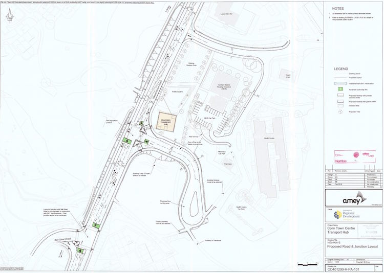
Plans for the Belfast Rapid Transit western
terminus at Colin Town Centre, consisting of a
terminal building and turning circle, but no car
park. Click for high-res version. [Amey/DRD]
2 Mar 2016: The team behind BRT have
published an updated
information leaflet to inform the public
about their plans. It doesn't say anything new,
but it's a useful summary. This week I spoke to
a person who lives on the Upper Newtownards Road
who had never heard of BRT, so anything that
leads to wider dissemination of what is planned
must surely be a good thing. The leaflet also
confirms that the western arm of BRT will
terminate at Colin
Town Centre (The Hub), meaning that the
section that would extend it from there to
McKinstry roundabout (where the park and ride
was originally to have been sited) will likely
now not be built. Presumably a park-and-ride
facility will be sited in some form at Colin
Town Centre though I have not seen this
confirmed. Meanwhile, work on the Andersonstown/Stewartstown
Road (Finaghy Road North to Upper Dunmurry
Lane [Michael Ferguson Roundabout]) has
been underway now for five weeks. A public
information event took place in the area on 11
and 12 February in Andersonstown Leisure Centre;
unfortunately I didn't get a chance to mention
this here beforehand. Additionally, the next
scheme in planning - the Albertbridge Road
(Castlereagh Street to Newtownards Road)
scheme ("H" on the map above) - has now appeared
on the "future tenders" list on the DRD web site
with a planned release date of April 2016 and an
estimated cost of £1.2m. The plan here is to
widen the road to allow two citybound lanes (one
for general traffic plus a bus lane) and one
countrybound lane. The road here is not wide
enough to allow four full lanes so this is a
compromise. The schedule for this one seems to
have slipped a bit: in October last year it was
estimated that work would begin on this scheme
in April, but it now seems as if it will only be
going out to tender by then. Finally, in
the Assembly two weeks ago the DRD
Minister was asked about a future extension
to north Belfast. She gave a tentative
timescale, suggesting that the DRD is serious
about this. She said "However, subject to
[the success of phase 1 and funding], an
outline provisional timeline for the extension
to north Belfast is as follows. In 2017-18,
the options assessment will be prepared. In
2018-19, a business case will be prepared and,
following assessment, the first phase will be
commenced. In 2019-2020, there will be the
detailed design and implementation, and, by
2022-23, I hope that it will be operational."
She also said that "the Antrim Road is likely
to emerge as the preferred option" (as
opposed to the Crumlin or Shore Roads). This
could mean running BRT across the Clifton Street
junction on Westlink which would be a challenge
to design!
23 Jan 2016: The contract for the Andersonstown/Stewartstown
Road (Finaghy Road North to Upper Dunmurry
Lane [Michael Ferguson Roundabout]) scheme
was
awarded to Whitemountain Quarries Ltd on
22 December 2015. The DRD have since said that
work will begin on Monday, 25 January and will
take just over a year, being completed in
"Spring" 2017. I have updated the progress map above to reflect this
development. The scheme involves the following:
- Carriageway widening and drainage system
improvements to enable the introduction of an
inbound bus lane for BRT.
- Resurfacing of 1.8km of carriageway and
adjoining footways.
- Improvements to the traffic signals and
pedestrian crossings at the Suffolk Road,
Blacks Road and Finaghy Road North junctions.
- Provision of a new signalised junction at
Shaw’s Road [currently
a priority T-junction].
- Upgrade of all existing pedestrian
crossings.
- Upgrade of street lighting to LED along the
entire section.
Interestingly, the DRD have referred to this
element as being part of "Phase 2", with all
previous elements (apart from the Upper
Newtownards Road (Albertbridge Road to Sandown
Road) scheme which is also underway as
part of Phase 2) being part of "Phase 1". These
"phases" seem to be a breakdown by time – as it
doesn't seem to be a breakdown by geographical
location. There are now three separate BRT
elements underway simultaneously (the third
being Divis Street/Falls Road (Millfield to
Grosvenor Road) scheme, also being carried
out by Whitemountain). No further elements of
BRT are listed in the Future
Tenders part of the DRD web site, although
design work is underway - see the map and table
above.
29 Nov 2015: On 26 November the DRD announced
that it had placed a £19m order for the 30 rapid
transit vehicles that will be required to run
BRT. The model of vehicle chosen is called Exqui.City
and are shown in the images
that I have added further up this page. They
will be built by Belgian-based company Van
Hool and will be supported locally by Road
Trucks Limited of Larne. It will take two
and a half years to build and supply all 30
vehicles, which means they should be ready in
advance of the scheduled opening date of
September 2018. The system will be operated by
Translink, who already run Ulsterbus, and Metro
buses in Belfast. The DRD press release explains
more about the vehicles: "The BRT vehicles
will be 18 metre long articulated buses with a
capacity of around 100 people. The tram-like
buses will be a key part of the BRT system
image. They will have three sets of double
doors providing easier and quicker boarding
and alighting, air conditioning and high
quality materials for passenger comfort, CCTV
for passenger safety and on-board passenger
information screens, audio announcements and
Wi-FI. The vehicles will utilise some of the
latest hybrid technology with lower noise,
vibration and pollutants." So far I have
heard quite a few negative comments about the
bus-like nature of the vehicles and the livery.
While there are things that could have been done
more ambitiously, I would nevertheless encourage
people to resist the temptation to dismiss it
and to give the system a chance - much effort
has already been put into the infrastructure,
and the vehicles will be of a higher quality
than anything in use in the city today. Because
of the experiences of the past in Northern
Ireland, we can often be guilty of excessive
cynicism but I would encourage folks to see how
the system operates in practice before assessing
its value. </soapbox> Meanwhile,
due to the complexity of the various elements of
the project, I have created a map showing the
various sections of the BRT infrastructure and
placed it further up this page,
below the table that lists the progress on the
same sections. I do hope this is useful. I have
also re-ordered the table so that the various
elements are in the order west to east.
29 Oct 2015: The Falls Road
(Grosvenor Road to Whiterock Road) scheme,
which began in September 2014, has
been completed and will come into use as
standard bus lanes on Monday 2 November. For
now, they will operate, city-bound and
country-bound, during peak hours only, from
7:30am to 9:30am and from 3:30pm to 6:30pm,
Monday to Friday. However once Belfast Rapid
Transit is completed in late 2018, they will
operate from 7am-7pm at least five days per
week. This is the third element of the BRT
scheme to have been completed. Since the last
update, work commenced on 12 October on the Divis
Street/Falls Road (Millfield to Grosvenor
Road) scheme, which was awarded to
Whitemountain Quarries Ltd on 8 September.
According to the latest
DRD procurement plan, the cost of the Andersonstown/Stewartstown
Road (Finaghy Road North to Upper Dunmurry
Lane [Michael Ferguson Roundabout])
scheme, currently out to tender, has risen
slightly from £2.5m to £2.9m, and the contract
is expected to be awarded in December 2015. The
document also gives us our first cost and date
estimates for some of the remaining elements,
and adds a new scheme hitherto not mentioned, Stewartstown
Road (Michael Ferguson Roundabout to Colin
Town Centre). "Colin Town Centre" seems to
refer to the "Hub" which is a proposed
community centre in Poleglass, visible on
the DRD's route
map. Finally, TransportNI have confirmed
to me that the Dundonald Park-and-Ride building,
which was closed in May 2015 following budget
pressures, has now re-opened. They said they
have "been able to redeploy a small number
of industrial staff to the Cairnshill and
Dundonald Park and Ride sites. They will
ensure the buildings are open during the day
for the use of the public and will also carry
out some low level maintenance activities."
26 Sep 2015: The tender for the Andersonstown/Stewartstown
Road (Finaghy Road North to Upper Dunmurry
Lane [Michael Ferguson Roundabout]) scheme
has now been published (sometime in the past
week) according to the DRD
web site. The closing date given is 29
October 2015. The scheme description says that
the main element is to widen the Stewartstown
Road to provide "a widened outbound lane.
Existing drainage networks will be upgraded to
include kerb inlet gullies, reducing
carriageway ironworks and improving bus ride
quality". It is good to see that the
resignation of the DRD Minister has not
prevented schemes going out to tender.
19 Sep 2015: The DRD has finally
conceded what I had long suspected, ie that the
timetable for this scheme has been pushed back
by a year to Autumn 2018. It did not come out as
a press release so I can't link to it but an
update has appeared on the DRD's
own site. They say "The potential for
delay was set out in the Department’s
consultation on the draft budget last November
[true] and severe budget pressures remain on
the Department and there is no certainty about
the position for future years." I see no
reason not take this at face value - we know the
DRD has found it very hard to allocate funding
to schemes, and since the BRT scheme is being
progressed via a series of separate contracts,
this would tend to make it very hard to progress
the scheme. I have already said that I felt the
pace of work was too slow to allow a completion
by Autumn 2017, and this is now official. That
said, work is underway now on two (soon three)
parts of the scheme. The photo below shows work
underway on the Upper Newtownards Road
(Albertbridge Road to Sandown Road) scheme
a few days ago. These particular contracts are
very "bitty" in their implementation, as they
often require extremely localised works such as
moving a kerb by a foot here, relocating a drain
there etc. They involve a lot of skill, but
aren't particularly high-profile or "sexy"
schemes.
Work underway for Belfast Rapid Transit on the
Upper Newtownards Road at Beersbridge Road
junction (on the right ahead), seen looking
countrybound on Thursday 17 September 2015. At
face value, the works here seem to involve kerb
relocation, but there may also be drainage works
going on judging by the deep excavation. [Wesley
Johnston]
14 Sep 2015: The fifth construction
contract for Belfast Rapid Transit, the Divis
Street/Falls Road (Millfield to Grosvenor
Road) scheme, was awarded to Whitemountain
Quarries Ltd on 8 September. I would anticipate
that work will get underway fairly soon so I've
gone ahead and marked it as "Underway" in the
table above, even though work may not
technically have started as of today. This means
three separate components of the scheme are now
underway simultaneously. Meanwhile, the tender
for the Andersonstown/Stewartstown Road
(Finaghy Road North to Upper Dunmurry Lane
[Michael Ferguson Roundabout]) scheme,
which was anticipated to be released in August,
has been pushed back again, this time until
September 2015. There is still no official
change to the official timescale, which is that
the scheme will be completed by Autumn 2017, but
this is feeling increasingly unlikely to me, not
helped by the fact that the DRD is now
effectively rudderless with the resignation of
the Minister last week.
There has been some
publicity recently around the number of
tickets that have been issued via the new fixed
and mobile cameras that monitor the bus lanes in
the city centre. The Donegall Square East camera
has been busiest, catching over 5700 people
illegally using the bus lane during the first
two months of operation, which is a little under
100 per day. Calm is required in this debate. On
the one hand, it is an offense for most vehicles
to drive in an operational bus lane, so most of
those who get caught are not being "turned into"
law-breakers, but are simply being caught
breaking the law. On the other hand, if the
signage and bus lanes are clearly marked, and
the issue is simply one of awareness, then logic
would imply that the number of fines issued will
rapidly drop off as the system beds in and the
public learns the new rules. If this does not
happen, then it suggests that awareness is not
the issue. I think 8 weeks is still too early to
conclude much on this question. But if we were
still seeing fines being issued at this level
by, say, Christmas time, then I think questions
would need to be asked about whether the public
have understood the rules and whether the
signage and/or lane markings need to be adjusted
to make them clearer. So I would encourage calm,
logical reflection in the bus lane debate!
13 Aug 2015: The bus lanes constructed
in the Upper Newtownards Road between Sandown
Road and Knock Road (the Outer Ring) and
completed in March came
into use on Monday, 10 August. Initially
they will operate at peak times only for normal
Metro buses, but once Rapid Transit is
introduced they will operate for 12 hours per
day. Meanwhile, the DRD web site has pushed back
the completion date for the Upper
Newtownards Road (Albertbridge Road to Sandown
Road) scheme, currently under
construction, from November 2015 to March 2016.
We now also finally have a proper schedule for
the Andersonstown/Stewartstown Road (Finaghy
Road North to Upper Dunmurry Lane [Michael
Ferguson Roundabout]) scheme, which is for
work to begin in January 2016 (earlier than
Spring 2016 estimated a couple of months ago)
with completion due in May 2017. Although this
scheme went out to tender in 2013, the DRD web
site is now saying that it is to go out to
tender again around August 2015 (ie anytime) so
the initial tender process must have been
terminated. Positively, the cost estimate for
this one has gone down from £3m to £2.5m.
Finally, the start of the Divis Street/Falls
Road (Millfield to Grosvenor Road) scheme
has been pushed back slightly from July 2015 to
September 2015, with completion now due in
August 2016. There is no further work on the
remaining elements. Although work is
progressing, the target completion date of 2017
feels increasingly unlikely to me.
10 Jun 2015: Further to the update two
days ago, the DRD
web site is now saying that construction
work on the fourth element of the project - Upper
Newtownards Road (Albertbridge Road to Sandown
Road) - will begin on 15 June. The
contract was awarded to Lagan Construction on 20
May and in my update on 29 May (below) I was not
sure whether or not work had begun. So that is
now clarified.
8 Jun 2015: Just a quick update
to note that the most
recent report to Belfast City Council
makes reference (page 14) to planning work now
being underway on three further components of
BRT. They are: Albertbridge Road
(Castlereagh Street to Newtownards Road),
Upper Newtownards Road (Knock Road to Dunlady
Road), ie to the Park and Ride in
Dundonald, and Falls Road/Andersonstown Road
(Whiterock Road to Finaghy Road North)
which I have now added to the list above. The
same report also suggests that the long-delayed
Andersonstown/Stewartstown Road (Finaghy Road
North to Upper Dunmurry Lane [Michael Ferguson
Roundabout]) scheme will get underway in
Spring next year, 2016. This is a full two and a
half years after this scheme went out to tender
(on 23 Oct 2013), so there must be some kind of
issue with this particular contract. Further
schemes will need to follow the ones listed
above, as this list does not yet include all
parts of the BRT network.
29 May 2015: Work on this scheme began a
year ago, in May 2014, and the scheme is
officially due to be operational sometime during
2017. It has been proceeding as a series of
small contracts, each for a particular stretch
of road or park-and-ride facility. There has
been both good and bad news for the scheme over
the past few weeks. On the plus side,
the fourth construction contract - for the Upper
Newtownards Road (Albertbridge Road to Sandown
Road) stretch - was awarded to Lagan
Construction on 20 May 2015. Construction is
likely to get underway soon if it has not
already. The duration of this scheme has been
previous estimated at six months. Secondly, the
tender for the Divis Street/Falls Road
(Millfield to Grosvenor Road) stretch has
now been advertised, with an estimated cost of
£2.5m and a closing date of 29 June. Since the
tenders then need to be assessed, this date
makes a July commencement date for the project
seem a little optimistic, but it is nonetheness
good news as it is the sixth element to go out
to tender. Thirdly, the DRD have now
announced that they will be introducing
six fixed cameras in the city centre, plus one
mobile detection vehicle, to monitor the bus
lanes and fine those caught using them
illegally. On the negative side, the
likely completion of the scheme does
increasingly appear to be slipping beyond the
official date of 2017. This is backed up not
only by monitoring the pace of work (see
previous update below), but also by the minutes
of a DRD meeting held just over a month
ago which talks about a possible "gateway
review" of Belfast Rapid Transit, which may mean
re-thinking the construction timetable. Finally,
the increasing financial pressures on the DRD
appear to have forced the closure
of the terminal building and removal of
all security personnel from the Dundonald
Park-and-Ride facility, which only opened on 1
December 2014. It is important to stress that
this is the closure of the building, not the
whole site, and the car park remains open
and continues to be served by express 4X
buses. Nevertheless, it is a retrograde step as
removal of security makes a car park much more
attractive to thieves, and closure of the
building makes waiting less comfortable,
particularly in inclement weather. With the
complete financial chaos that reigns in Stormont
as of this week, it would not be too
melodramatic to say that literally everything is
on the table in terms of when or even whether
future road schemes will go ahead.
17 Apr 2015: The improvements to the Upper
Newtownards Road (Sandown to Knock
Road) were completed on 27 March 2015.
That marks completion of the second element of
the project, so congratulations to the project
team. There is just one element currently under
construction, and that is the Falls Road
(Grosvenor Road to Whiterock Road) scheme
which began in September 2014. Originally
scheduled for completion in July 2015, then
delayed to August and it now looks to have been
delayed again as estimated completion is now
being given on the DRD
web site as "October 2015". Three elements
are in planning (see above), but none have as
yet commenced: The Upper Newtownards Road
(Albertbridge Road to Sandown Road) scheme
is still due to commence in May 2015. It has
been out
to tender since January, and as yet no
contractor seems to have been appointed. The Divis
Street/Falls Road (Millfield to Grosvenor
Road) stretch was due to commence in May
2015 but this has now been pushed back to July
2015. It does not appear to have gone out to
tender yet, so even this looks a bit optimistic
at this stage. The Andersonstown/Stewartstown
Road (Finaghy Road North to Upper Dunmurry
Lane) element has been out to tender since
October 2013 but has yet to be awarded, implying
there is some sort of issue preventing this one
going ahead. Finally, there are of course a
large number of additional elements that have
yet to progress to the point of going out to
tender.
Actual construction has now been underway for
11 months. According
to the DRD, the whole system is due to
become operational in Autumn 2017, which is
about 30 months from now. The total length of
the project - in terms of dedicated rapid
transit lanes - is just over 24km, and to date
work has been completed or is underway on about
2.4km of this. Some additional lengths, such as
the 3km in the city centre, don't require much
more work since they were largely built as part
of the Belfast on the Move bus lane
project. So at this point we've only commenced
or completed work on around 10% of the scheme,
but are more than a quarter of the way through
the construction period. The pace of work does
appear to be slower than would be necessary to
complete the whole project by Autumn 2017 as
planned. This may be due to the financial
situation, or it could be that the pace of work
will increase over the coming year. Watch this
space.
7 Feb 2015: As stated in the previous
update, work on the Divis Street/Falls Road
(Millfield to Grosvenor Road) stretch is
due to commence in May 2015. It was announced
this week that on 12 and 13 February there will
be a public information event to let residents
know what is planned and give you an opportunity
to speak to the planners of the scheme. It will
take place in Falls Road Library on
Thursday 12th February 2015 between 11:45am and
7:45pm and on Friday 13th February 2015 between
9:45am and 1:45pm.
28 Jan 2015: A quick update to note that
the fifth tender for the project was released
on 13 January 2015. It covers works to the Upper
Newtownards Road (Albertbridge Road to Sandown
Road). The estimated cost of this element
is given as £1.5m. The start date has been
pushed back slightly to April 2015, but the
completion date is still being given as November
2015. Meanwhile, the DRD
web site now says that the sixth element,
Divis Street/Falls Road (Millfield to
Grosvenor Road), will get underway in May
2015 and be completed in June 2016. This
timescale would require the tender for this
element to be issued within the next month or
so. Finally, the same web page is no longer
giving an estimated start date for the Andersonstown/Stewartstown
Road (Finaghy Road North to Upper Dunmurry
Lane) element which has been out to tender
since October 2013. There is presumably some
issue here. The Northern Ireland Budget 2015-16
which was published
a couple of weeks ago thankfully continues
funding for this scheme.
7 Dec 2014: The first component of
Belfast Rapid Transit to be completed, Dundonald
Park-and-Ride, opened to traffic on 1
December 2014. I have driven past it each
morning since then and a few dozen commuters
appear to be using the site already which is an
encouraging sign so early on. The 520-space site
is located here
and is accessible via fully
traffic-light-controlled junctions. Engineers
were evident on the first few days watching how
traffic responded to the change and making
adjustments. The traffic signals on Upper
Newtownards Road at Dunlady Road may be
triggered by buses since I've noticed that a bus
emerging from the park-and-ride seems to cause
the signals to change early. This is likely
deliberate, to give buses the shortest possible
waiting time. The park-and-ride is served by
Ulsterbus services. However, during the morning
and evening peaks (roughly 7-9am and 3pm to
roughly 6.45pm) it has its own dedicated express
Metro service, the 4X - timetables
here. The photos below show the completed
terminal building in use. Meanwhile, we are
still awaiting a definite start date for the
scheme to construct the BRT infrastructure on
the Divis Street/Falls Road (Millfield to
Grosvenor Road) stretch. The minutes of a
TransportNI Board meeting held on 1 October (but
just published)
says "ongoing discussions are taking place
with DSD/BCC [Dept of Social Development and
Belfast City Council] in relation to the
delivery programme and funding for the works
on the Falls/Divis scheme". The DSD is
responsible for public realm works (such as nice
footpaths) and Belfast City Council will be
taking on this role from April 2016. So this
sounds like the DRD, DSD and BCC are working
together to ensure that they combine their
various plans for this road so that someone
isn't coming along and digging stuff up weeks
after it's built. This is the sort of thing that
attracts much criticism, so the fact that the
three bodies seem to be collaborating in this
locality deserves to be highlighted and
applauded. Finally, in terms of overall
timescale, the DRD has released a
draft budget for the period 2015-16. In
the face of significant funding cuts, the
document commits to completing Rapid Transit,
but it does contain the worrying comment that "it
may be necessary to manage delivery over a
longer timeframe". The system is due to
the completed and operational by Autumn 2017 so
this suggests funding cuts may push this
timescale on a bit. (With thanks to Steven
Patterson for a correction.)
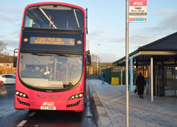 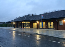
4X Metro service serving the new Dundonald
Park-and-Ride. [DRD image from
here]
23 Nov 2014: Work on the park-and-ride
site at Dundonald seems very well advanced
with the car park largely completed, as shown in
the picture below. The new traffic signals for
its junction onto Dunlady Road are now in place,
covered with orange hoods. It is due to be
completed in December, so it should open any
time. It will initially operate as a
conventional park-and-ride served by Metro
buses, presumably (hopefully?) beginning early
in 2015. TransportNI has also confirmed that all
BRT works will be suspended from tomorrow
(Monday 24 November) until Friday 2 January as
part of their "Christmas roadworks embargo".
They do deserve the appreciation of motorists
who have tolerated the various works for this
gesture of goodwill. This may be part of the
reason why the completion date for the works on
Upper Newtownards Road (Sandown Road to Knock
Road) has been pushed back quite
considerably from November 2014 to February
2015. This revision suggests that the works are
behind schedule and have not been completed
prior to the Christmas works embargo beginning.
The fact that they will now not be able to do
any work for six weeks is why it will probably
take until February to complete everything. The
completion date for the Falls Road
(Grosvenor Road to Whiterock Road) scheme,
which began in September, has also been pushed
back slightly from July to August 2014. The Andersonstown/Stewartstown
Road (Finaghy Road North to Upper Dunmurry
Lane) scheme was due to have begun in
January, but is now expected to begin in March.
There seems to be a bit of a delay in awarding
the contract for this component - at the time of
writing a contractor does not seem to have been
appointed. TransportNI are keeping their
own page on this scheme impressively up to
date so it would be worth bookmarking it.
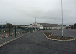
The almost-completed car park for the Dundonald
park-and-ride, seen on 3 November 2014
[TransportNI image from
here].
22 Sep 2014: Just a quick update to let
you know that the BRT team are holding two public
information events in east Belfast to
inform people about the impact that this scheme
is going to have on the Newtownards Road from
Albertbridge Road to Sandtown Road. They are
being held in Holywood
Arches Library on Thursday 25th September
2014 between 12:30pm and 7:45pm and on Friday
26th September 2014 between 12:30pm and 5:15pm.
18 Sep 2014: Due to the increasing
number of components getting underway, I have
now added a table above to help you keep track
of it all. At Dundonald, works to adjust the
lanes approaching the Dunlady Road junction for
the new park-and-ride facility appears to have
finished. You can see photos of this work on the
DRD's
web site. Three elements of the project
are now underway, but there does seem to have
been some sort of hitch with the fourth project
(Andersonstown/Stewartstown Road - Finaghy Road
North to Upper Dunmurry Lane) which we had been
expecting to begin in October 2014 but has
slipped back to January 2015 in recent weeks.
This part of the project has been out
to tender for almost 11 months, but for
some reason has not been awarded yet. Meanwhile,
two further projects have now appeared on the
DRD's web site - Upper Newtownards Road
(Albertbridge Road to Sandown Road) and Divis
Street/Falls Road (Millfield to Grosvenor
Road), both of which are estimated to get
underway in February 2015. Neither appears to be
yet out to tender.
5 Sep 2014: Further to the previous
update, it is now confirmed that the work to
prepare the section of Falls Road, Grosvenor
Road to Whiterock Road will commence on
Monday 8 September, and last 12 months. The
Rapid Transit team have also put 5 photos of
recent works on the Newtownards Road on their
web site here.
25 Aug 2014: The third construction
tender, to prepare the section of Falls
Road, Grosvenor Road to Whiterock Road was
awarded
to John McQuillan (Contracts) Ltd on 13 August.
Construction is due to begin during September.
At the works for the Dundonald Park-and-Ride
site, work began over the past week on the Upper
Newtownards Road itself with work to extend the
right-turn lane approaching Dunlady Road
commencing and ducting for the revised traffic
signals being put in place.
16 Aug 2014: Work has been continuing in
earnest on the Dundonald Park and Ride,
which began three months ago. The terminal
building is now rising recognisably (see picture
below) and the earthworks for the car park are
also well advanced. Work has taken place on
modifying the access onto Dunlady Road from the
site, which will eventually be a signalised
junction. No significant work has yet begun on
upgrading the nearby Upper Newtownards Road /
Dunlady Road junction which also needs to be
upgraded, but there is evidence of what might be
service ducting being installed to carry new
cabling. These works are due to be completed in
December 2014. The works to date on the Upper
Newtownards Road, Sandown Road to Knock Road
are somewhat hard to interpret. There are a lot
of cones about, and lane closures, and there
appear to have been changes to various elements
including the drains at the side of the road.
But it's hard to yet see how it all fits
together. These works are due to be completed in
November 2014. The start date for works on the
section Falls Road, Grosvenor Road to
Whiterock Road has now been put back
slightly to September 2014 (completion due July
2015), while the start date for the section Andersonstown/Stewartstown
Road, Finaghy Road North to Upper Dunmurry
Lane is now being given as October 2014
(completion due November 2015). These latter two
have much longer timescales than the current
works to the Upper Newtownards Road, suggesting
that they involve more substantial work. Once
again, keep an eye on the DRD
web site for this scheme which is being
kept impressively up-to-date with progress on
these various elements.
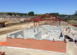 DRD photo of the terminal
building Dundonald Park-and Ride taking shape on
25 July 2014. You can see more photos here.
[DRD]
19 Jun 2014: The DRD has now re-launched
their web site which now features details
on each element of the scheme and progress on
it. That page is likely to be kept more
up-to-date than I can keep this page updated (!)
so it would be a useful one to bookmark. It also
features an informative section of Frequently
Asked Questions. It confirms the timetable
for the first four elements as below. This means
that the second element of the scheme will kick
off on the Upper Newtownards Road on Monday 23
June.
- Dundonald Park and Ride -
UNDERWAY - commenced 19 May 2014, due to be
completed Dec 2014. Will initially be served
by Metro buses, switching to Rapid Transit
vehicles in 2017.
- Upper Newtownards Road, Sandown Road to
Knock Road (1km - see
map) - localised widening, relocating
drains and upgrading pedestrian crossings - to
commence 23 June 2014, due to be completed
November 2014.
- Falls Road, Grosvenor Road to Whiterock
Road (1.3km - see
map) - localised widening, relocating
drains and upgrading pedestrian crossings - to
commence August 2014, due to be completed July
2015.
- Andersonstown/Stewartstown Road, Finaghy
Road North to Upper Dunmurry Lane
(Michael Ferguson Roundabout) (1.9km - see
map) - road widening to create a
citybound bus lane (presumably there will be
no outbound bus lane), and upgrade of traffic
signals.
7 Jun 2014: Since the last update, the
second construction contract has been awarded.
This one is the works to adjust the layout along
1km of the Upper Newtownards Road from Sandown
Road (Ballyhackamore) to Knock Road (the Outer
Ring) to accommodate Rapid Transit. It was
awarded to White Mountain Quarries Ltd on 21 May
2014. The estimated value of the contract is
£1.43m. There is no immediate sign of work
beginning at the time of writing. Meanwhile, at
the Dundonald park-and-ride site, where work has
been underway now for almost three weeks, a lot
of site earthworks are very evident indicating
good progress. There has been no work as yet on
the associated improvements to the Upper
Newtownards Road / Dunlady Road junction which
are part of the scheme. The third
contract that is in the pipeline has still
to be awarded.
19 May 2014: Work finally began today on
construction of the Dundonald park-and-ride
site, the contract for which was awarded to
Lagan Construction on 28 March. Since this is
the first element of Belfast Rapid Transit to go
to actual construction, today marks the official
commencement of the construction phase of the
project. For this reason, it was accompanied by
a press
release and media
coverage. The press release notes that
procurement for the 40 Rapid Transit buses is to
begin, with £20m being allocated for the task.
The Minister estimates that the whole process of
procurement, construction and delivery of the
vehicles will take three years, with the three
routes (WWAY - from Stewartstown Road, EWAY from
Dundonald and CITI from Titanic Quarter) to open
for business in autumn 2017. The press release
also notes that two further construction
contracts are due "to start next month", ie June
2014. This presumably refers to the two sections
that have been out to tender for some time (here
and here)
but have yet to be awarded. This incarnation of
the BRT scheme was first announced in the 2002
Regional Transportation Strategy, so it is
exciting that it has finally reached the point
of construction. Listening to the radio and
discussing it on Twitter suggests widespread
public ignorance of even the existence
of this scheme, let alone the route it will
follow and impacts it will have. So hopefully
the next three years will see a proactive public
information campaign to raise awareness.
4 Apr 2014: The first tender for Belfast
Rapid Transit - the construction of the
Dundonald park-and-ride site - was awarded
to Lagan Construction on 28 March 2014. As
contractors tend to be keen to start work as
soon as possible, I would expect to see work
beginning imminently. The estimated value of the
contract is £1.57m. It will primarily involve
the construction of a 521 space car park with a
terminal building, sited here
in Dundonald. However, it will also require
changes to the adjacent Dunlady Road, and
alterations to the Dunlady Road/Upper
Newtownards Road junction. This will include
lengthening the right turn lane when coming from
Newtownards as many more vehicles are
anticipated to want to turn right here. As this
is the first Belfast Rapid Transit contract,
until the whole scheme is completed the
park-and-ride facility will by served by
conventional buses. The estimated duration of
the works is 8 months, so we could expect to see
it completed by early December 2014. Meanwhile,
two other tenders are still to be awarded (see
previous update below).
22 Jan 2014: These are exciting times
for supporters of this scheme, as it edges ever
closer to actual construction. In the previous
update three months ago I noted that the first
actual construction tender (for 3.8km of WWAY,
about 40% of the bit in West Belfast) had been advertised.
This tender has not yet been awarded, but the
closing date was 28 November 2013 so surely it
cannot be far off now. Since then, the second
tender has also been advertised
- the construction of the Dundonald
Park-and-Ride which will form the terminus of
EWAY, the bit in East Belfast. This tender was
released in December 2013, earlier than
expected, with a closing date of 3 February
2014. The third tender,
for a 1km stretch of EWAY from Sandown Road to
the Outer Ring, is due to be released
imminently. At this rate of progress, and
barring any difficulties with the tender
process, I think it is likely that we will see
work commencing on WWAY before the summer. The
whole Rapid Transit system (consisting of EWAY,
WWAY and the CITI link into Titanic Quarter) is
due to be completed by 2017/18. Presumably some
work will also have to take place between now
and then to tweak the new city centre bus lanes
to accommodate Rapid Transit. This has always
been the intention, but it will require a bit
more work - perhaps additional traffic signals,
the construction of several rapid transit
"halts", and certainly some meaningful
enforcement of the bus lanes which are woefully
enforced at present.
28 Oct 2013: Work seems to be rapidly
gearing up towards a commencement of the Belfast
Rapid Transit project. The first tender for
construction of the road infrastructure was
advertised on Wednesday last week. This
contract covers two sections of WWAY (the
bit in West Belfast): the 2km from Grosvenor
Road to Whiterock Road; and the 1.8km from
Finaghy Road North to Old Colin Road). Together
these constitute roughly 40% of WWAY. It's not
clear when work would begin, but the first
tender closes on 28th November and I would
expect that work would be likely to commence,
therefore, during the first half of 2014. The
project is scheduled to take 11 months, so would
be completed by early 2015. They will probably
initially operate as normal bus lanes while the
rest of the project is completed.
Information on Roads Service's own web site
suggests that this tender will be followed in
January by two more: a 1km stretch of Upper
Newtownards Road from Sandown Road to the Outer
Ring, representing just over 10% of the EWAY
route; and the Dundonald park-and-ride site.
Combined, these three projects account for about
20% of the total length of Rapid Transit and
represent a good start.
23 Sep 2013: While it now looks unlikely
that any work on the ground will begin during
2013 as hoped last December (see below) work on
this project is definitely progressing. The
first two planning applications (that I am aware
of) are now in - with thanks to Gary Potter over
at Future
Belfast for alerting me to these. The first
one is for the terminal
park-and-ride at Dundonald, which we now know is
to be sited in the grounds of the former
Lidl supermarket at Dunlady Road in
Dundonald. It is to have 521 parking spaces. Click
here to see a PDF of the traffic flow
assessment, which includes a map of the proposed
facility near the end. Both the WWAY (West
Belfast) and EWAY (East Belfast) routes will
terminate at such facilities, which are
considered vital to their operation. Dunlady
Road is a better place for a park-and-ride than
the earlier proposal at Quarry Corner, since
Robb's Road is a natural point of divergence –
this will help traffic flows on the main Upper
Newtownards Road which will have to reduced from
two to one lanes from this location into the
city centre. This is also likely to the the most
unpopular part of the plan. The plan for the
park-and-ride involves lengthening the right
turn lane from the main A20 citybound into
Dunaldy Road, and also adding new traffic lights
at the
Dunlady Road/park-and-ride junction. The second
one is for localised road widening
on Divis Street to allow for the provision of
dedicated bus lanes in both directions at this
point. Although more modest in scale than the
first planning application, this one is also
vital as the bus lane must be continuous, as far
as possible, to provide the journey times needed
to make it attractive to travellers. At this
point in time it seems likely that at least some
work will begin on the ground during 2014, with
all three pilot routes (WWAY, EWAY and CITI
[Titanic Quarter] due to be operational by
2017/18).
12 Dec 2012: In a talk at the PLACE
Architecture and Built Environment Centre today,
Ciarán de Búrca (the head of the project) stated
that work to implement the necessary
infrastructure for Rapid Transit would begin on
the ground at the end of 2013, ie in one year,
and that the system would be finished and
operating in 2017. He also confirmed all three
routes would be opening simulatneously. He also
said that the dedicated Rapid Transit lanes
would not run straight through the Outer Ring /
Upper Newtownards Road junction due to its sheer
importance to strategic traffic. Finally, he
confirmed that cyclists would not be
banned from the bus lanes once the Rapid
Transist system was operating.
1 Dec 2012: Further to the last update,
where I commented that the location of the
proposed park-and-ride site in Dundonald was not
specified, I have heard a rumour that the DRD
has made an offer for a piece of land in
Dundonald for a 400 space site. I don't know
what site this actually is, but the reference to
400 spaces would be consistent with the size of
this
vacant site. There is also some vacant
land at the site of the old Rolls-Royce factory
here.
23 Nov 2012: The DRD yesterday published
a summary version of their Outline Business
Case. You can access it, along with an updated
map of the proposed routes, from
here and the press release here.
There is a lot to read here, but as this web
site focuses on the impact on the road network,
I'm mostly restricting my comments here to that
aspect of the plan. Of note are the following
points:
- The decision made a year ago to route WWAY
along Grosvenor Road, rather than Falls Road
has been reversed, due to public
pressure expressed in the last public
consultation. WWAY will now run along Falls
Road, as can be seen from the map linked to
above. I've updated the text at the top of
this page with the most recent route corridor
information.
- The remainder of the routes remain largely
unchanged from what was previously publicised.
- There will be a park and ride on WWAY "near
Dairy
Farm and/or McKinstry
Road Roundabout".
- There will be a park and ride on EWAY "in
Dundonald". Although documents last year
indicated this would be at Quarry
Corner, this is no longer being
specifically mentioned. The new map is shows
it at Ballybeen
Estate. This may just be indicative,
however.
- The scheme has a calculated cost-benefit
ratio of 3.4, which would be considered good
value for money, ie over the assessment period
(usually 60 years) will will bring 3.4 times
more benefit than it will cost to build. It is
not anticipated that revenue will be
sufficient to cover the investment costs
within the assessment period.
- The total cost is estimated to be £98.5m,
assuming it opens in 2017/18. This is actually
less than the £150m estimated in 2008. Of
this, £12.5m is already allocated up to 2015.
Proceeding with the plan to be open in
2017/18, therefore, will require an additional
£86m to be allocated between 2015 and 2017/18.
Yesterday's announcement that the scheme has
secured Executive approval suggests this is
likely to be forthcoming.
- BRT is predicted to increase public
transport patronage on the route corridors by
between 43% and 75%, and reduce public
transport journey times by 30%.
- BRT is predicted to reduce general traffic
levels on the route corridors by 20%, of which
half is modal shift from car to BRT and 10% by
cars switching to other parallel routes.
Journey times for general traffic are
predicted to increase by 8% generally, but up
to 40% in certain locations.
- On-street parking will be reduced in areas
where BRT is built.
- Each of the park-and-ride centres will have
space for 500 cars plus secure cycle
facilities.
30 Jul 2012:
According to the minutes
of a DRD Board meeting held on 2nd July, there
has been a discussion between Geoff Allister,
the Head of Roads Service, and Ciarán de Búrca,
the Head of the Rapid Transit Division. The
discussion seems to have focused on the issue of
"traffic disruption/increase in car journey
times forecasts". This is because the scheme
will see key arterial routes reduced from two to
one lane each way, most notably the A20 Upper
Newtownards Road which is not simply a commuter
route, but also part of the Strategic Road
Network, linking the Ards Peninsula to the rest
of Northern Ireland. It has been agreed that
there will be a re-assessment of the current
status of the A24 Saintfield Road. This is
presumably because the A24 is also a strategic
road, and a similar reduction in capacity was
implemented there when the bus lane was opened a
few years ago. The disruption to strategic
traffic on the A20 will be one of the most
sensitive aspects of the Outline Business Case.
1 May 2012:
The DRD have published their Consultation
Report into last Autumn's public
consultation (along with an Equality
Impact Assessment) on 24th April. The main
findings of the consultation are:
- 62% of people thought that the most
appropriate routes had been considered. The
main objection was to the choice of Grosvenor
Road over Divis Street for WWAY. There seems
to be a broad consensus that the Comber
Greenway should not be used for EWAY.
- 88% felt that the proposed system would be a
"high quality public transport system".
- Quite a few people felt the system ought to
be expanded to cover other parts of Belfast.
- Concerns about the level of fares and impact
on 'regular' buses.
- The importance of good park-and-ride
facilities.
The report concludes by noting that an Outline
Business Case will be published late in 2012
that will consider the emerging design more
specifically, especially the impact on specific
junctions and property along the route. There
will be another round of consultation after
that. Although there is a question mark over
when funding will be available, it does seem as
if development of the scheme is progressing
well.
Personal
comment: While supportive of the scheme in
principle, I did make a submission
to the consultation outlining my concerns
about the 'pinch point' that will be created
citybound at Quarry Corner (similar to that at
Greenisland).
15 Jan 2012: I
have just realised that I did not write an
update for the official announcement that I
mentioned in the previous update - apologies.
The Route Options for the pilot phase of Belfast
Rapid Transit were announced on 12 October, and
the public consultation ran from then until 6
January. The report is accessible
here. Although the consultation was about
"route options", in practice the report
goes on to reject all but one option for each of
the three routes and therefore would be more
correctly described as a "preferred route"
announcement. The preferred routes are as
follows (the route in Belfast City Centre itself
is not yet finalised):
- CITI - City Centre > Queen's Quay >
Queen's Road
- EWAY - City Centre > Albertbridge Road
> Upper Newtownards Road to Quarry Corner
park-and-ride
- WWAY - City Centre > Grosvenor Road >
Falls Road > Andersonstown Road >
Stewartstown Road to McKinstry Road roundabout
park-and-ride
These are bold proposals, in that they will
require significant reallocation of roads space
from general use to public transport. The most
controversial element (in my view) is the
decision to route EWAY along the stretch of
Upper Newtownards Road from the Outer Ring to
Quarry Corner, as this is part of the strategic
road network, unlike the remainder of the
system. This decision has been made due to
significant public opposition to the use of the
Greenway
route. Advocates of Rapid Transit have raised
concerns that DRD may be tempted to save money
by downgrading the quality of the vehicles used
on the system, and so we hope this does not
happen. Meanwhile, measures to prepare the city
centre for rapid transit are well underway, with
Phase
2 of the enabling measures already
underway (and Rapid
Transit Enabling Measures planned). The
DRD is still being vague on when exactly
construction work on the Rapid Transit system
itself will commence. It is currently planned to
be in operation by 2017 (see update 12 Sep
2011). There is no update on cost, which was
last estimated at £150m four years ago.
8 Oct 2011:
Information leaked
by the BBC yesterday indicates that the
plan to use the Comber Greenway has now been
abandoned, with some kind of announcement
expected in the coming week to coincide with the
commencement of a public consultation on 12
October. The reason given is "cost", although
there has been significant
public opposition to the proposal. Watch
this space.
12 Sep 2011: The new "Transport" Minister today
offered some more information on where we
are with this scheme during
the first session of the Stormont
Assembly of the autumn. He noted that there
would be a three month consultation
exercise, beginning next month (October
2011). An "outline business case" will then
be completed "in 2012" at which point the
planners will seek permission from the
Executive to proceed. He confirmed
that there are no plans to commence major
construction work before 2015, but did
comment that the budget for the period to
2014-15 does include money "for the
planning and commencement of initial
implementation measures",
presumably the detailed design, etc, and
possibly some minor works such as
adjustments to road junctions that will be
affected. Finally, he said that "the target
date for the operation of the system is
2017" but went on to say that "that is very
much an aspiration and is subject to
available finance". So I don't
think we can say anything firm about if or
when this scheme will be implemented.
14 May 2011: My scepticism
about the timescale for this project (see
previous update) seems to have been well
founded. Speaking at the Annual Dinner of the
Chartered Institution of Highway Enginners
Northern Ireland, the Permanent Secretary of the
Department for Regional Development Malcolm
McKibbin said "funding to begin to implement
[the Rapid Transit System] will not be
available until at least 2015" (quoted in
Plant & Civil Engineer, May 2011). So this
means that we are probably at least four years,
and possibly more, away from work actually
beginning on the ground.
7 Mar 2011: The Minister answered
a question on the status of this scheme in
the Assembly three weeks ago. He did not give
any dates, but did say: "this project is
identified in the Programme for Government as
a key project for Belfast, and we want to keep
it live and on the books. Although I would
prefer that we were much further ahead with
the capital commitment to rapid transit, we
will continue with the preparatory work."
This does not sound like the description of a
project that is likely to start on the ground
next year, as was being said last summer. It
sounds more like a project that is on a longer
finger, awaiting funding or more progress on
design work. We shall have to wait for more
information to see where we are with this
scheme.
14 Jan 2011: The DRD published
their draft budget for 2011-15 yesterday.
Despite savage delays to many schemes, this
scheme appears to have survived. The budget
states that "The spending proposals would
also allow the Department to fund the
development of a bus based Rapid Transit
system on a pilot network of three routes
connecting East Belfast, West Belfast and
Titanic Quarter with and through the City
Centre." It's not clear, however, if
there will be delays. Currently work on the
first scheme is scheduled for the end of 2012
(see previous update).
15 July 2010: Roads Service
have released
a public information leaflet about the scheme.
It doesn't say much that we don't already know,
but it does say that commencement of the first
route is now expected "during 2011". However,
this is contradicted by the DRD's own End
of Year Report issued a few days later. In
relation to the scheme it says "We have been
advised not to undertake public consultation
on the preferred routes whilst this process is
ongoing. This has resulted in a delay in
taking forward the project by 9-12 months. The
three routes set out in the Strategic Outline
Case will now be taken forward in a single
Outline Business Case. This includes further
route options which will require full public
consultation. The revised target date to
commence work on site for the CITI-route is
end of 2012." CITI is the route
connecting the City Airport and Titanic Quarter,
and is likely to be the first one built.
28
Mar 2010: In the Assembly earlier
this month, the Minister said that the
public consultation into the details of the
three routes of the proposed rapid transit
system have been deferred until "early 2011".
This is apparently due to the existing public
consultation on the legislation that will allow
rapid transit to operate. He said "there was
a possibility of confusion arising if the
public were also being consulted on the
details of route alignment options during the
enabling legislation process." This has
not prevented debate about the route - the most
controversial part is the plan to route the
rapid transit system along the Greenway (a
former railway line and current cycle/foot way)
through east Belfast. Such is the strength of
feeling locally, that it has spawned a campaign
group - Greenway
to Stay. The DRD has already spent
considerable sums on the Greenway proposal, and
has even bought a site related to the scheme,
but it seems if a route along the Upper
Newtownards Road will also have to be
considered. At the project launch in November
2008 it was stated that work on the rapid
transit system would begin "in 2011". With a
consultation into routes not planned to begin
until early 2011, this timescale seems
increasingly unlikely to be achieved.
|