|
Maps
of Ireland CONTENTS |
. |
|
|
Maps
of Ireland CONTENTS |
. |
|
|
. |
Currently listing 54 maps of Ireland, in the following categories: | Street Maps | Historical | General
Maps | Electoral | Religious | It is our policy to give away our maps of Ireland free for fair-use purposes. All maps can be used unmodified on other non-profit web sites. If you do use the maps, a link to www.irelandstory.com is all that we ask. Note that this freedom does not apply to other material on this site. Please note that these maps were all produced in the late 1990s through to 2001 but are not being updated as the people who created them are no longer actively involved with this site. |
. |
| Street Maps of Towns & Cities | |
| Belfast | Street map of Belfast, with 93 main roads and 18 prominent buildings marked. Scale 72 pixels = 1km. [82kB] |
| Dublin (greater) | Map of Dublin city, with 241 main roads and 38 prominent features marked. Scale 72 pixels = 1km [115kB]. This map is of greater Dublin and thus does not give detailed information on the city centre. Available separately is the map without the list of roads [91kB] and the list of roads on its own [25kB]. Note: this is a large map: 1141 x 1242 pixels. |
| Derry | Street map of Derry, with 80 main roads and 16 prominent buildings named. Scale 72 pixels = 1km. [46kB] |
| Omagh Town Centre | Map showing the town centre in Omagh and the location of the August 15th
1998 bomb explosion. Approximate scale 600 pixels = 1km. [12kB] More information on the Omagh Bomb. |
| Portadown Garvaghy Area | Map of the route of the Drumcree Orange parade and the Garvaghy Road area of Portadown, county Armagh. Also shows the area that is predominantly Roman Catholic. [19kB] |
| Belfast Religious Breakdown | Map of Belfast divided into Electoral Wards. Each ward is coloured to indicate the proportion of Roman Catholics who make up the population. Scale 72 pixels = 1km. [98kB] |
| Derry Religious Breakdown | Map of Derry divided into Electoral Wards. Each ward is coloured to indicate the proportion of Roman Catholics who make up the population. Scale 72 pixels = 1km. [34kB] |
| Historical
Maps All these are taken from the History Section of this site. |
|
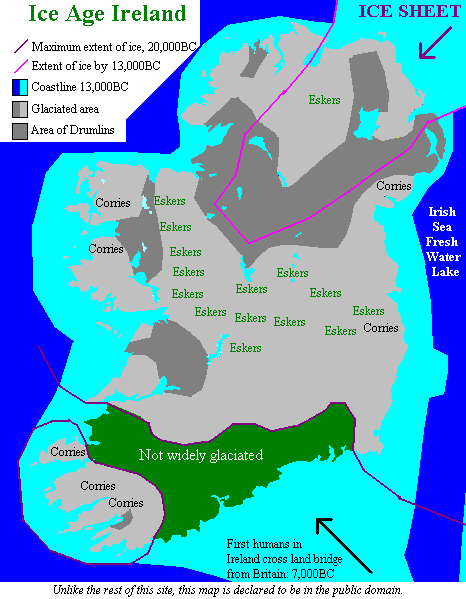
| Ice Age Ireland | Map showing the extent of the ice coverage in Ireland as well as the locations of the lower coastline and glacial landforms. (There is more information on the Ice Age and Ireland's Physical Landscape.) [19kB] |
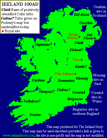
| Ireland 100AD | Map showing the main Celtic tribes living in Ireland in 100AD. Also shows the leading royal sites. (View this map in context.) [10kB]. |
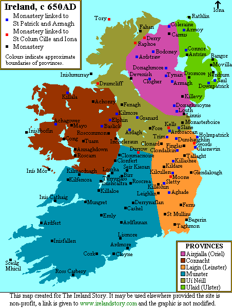
| Ireland 650AD | Map showing the Provinces in Ireland around 650AD, 200 years after St Patrick. Also shows the locations and names of the Christian monasteries in Ireland. (View this map in context.) [20kB] |
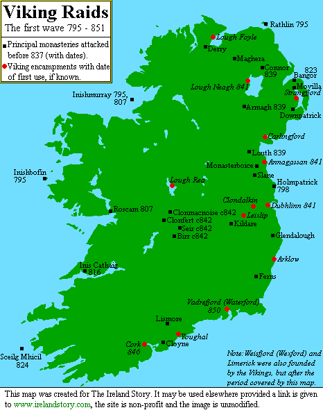
| Ireland 795-851 | Map showing Ireland in the early Viking period, showing the main monasteries attacked and the Viking encampments, labelled with dates. (View this map in context.) [14kB] |
| Ireland 950AD | Map of Ireland as it was around 950AD, showing the layout of the provinces, kingdoms and Viking territories and towns. (View this map in context.) [15kB] |
| Ireland 1300 | Map of Ireland in 1300AD, showing the maximum extent of Norman control in Ireland and their main settlements. [11kB] |
| Ireland 1450 | Map of Ireland in 1450, during the Norman decline showing the Celtic areas, Anglo-Irish areas and the English-ruled Pale. [14kB] |
| Ireland 1609 | Map of Ireland in 1609, showing the 3 main Plantations that took place between 1556 and 1609. [11kB] |
| Cromwell in Ireland | Two-in-one map of Ireland in 1641 and 1703 indicating the effect of Oliver Cromwell's period of rule of Britain and Ireland. Compares the proportion of land in each county in Ireland that was owned by Roman Catholics. [11kB] |
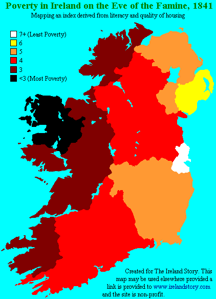
| Poverty in Ireland, 1841 | Map indicating the levels of poverty in Ireland on the eve of the Great Famine. An index based on literacy and housing standards. [11kB] |
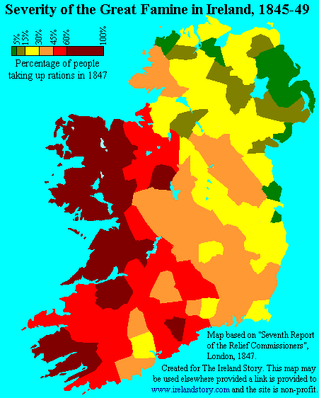
| Severity of the Famine, 1847 | Map showing the varying level of severity of the Great Famine across Ireland at its height in 1847. [13kB] More information on the Famine. |
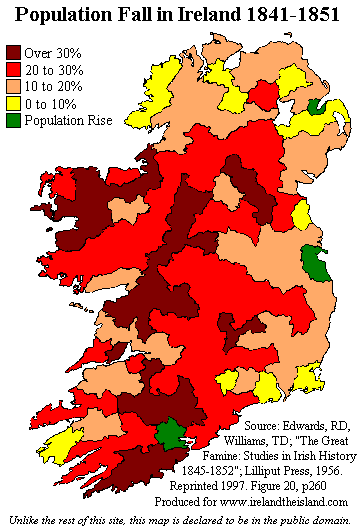
| Population Fall in Ireland, 1841-1851 | Detailed map showing the levels of population fall over the Famine period in each part of Ireland. [14kB] More information on the Famine. |
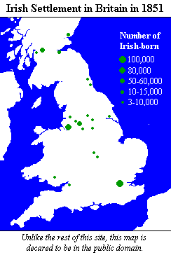
| Irish Settlement in Britain, 1851 | The locations in Britain where Irish-born who emigrated to Britain settled [5kB]. |
| Protestants in Ireland, 1861 and 1991 | Two-in-one colour-coded map showing the change in the distribution of Protestants in Ireland between 1861 and 1991. [13kB] |
| Declining Protestant population in the Irish Republic 1891 to 1991 | Graph showing the proportion of the population of the Irish Republic who were Protestant in censuses in the period 1891 to 1991. [7kB] |
| Changing Republican Activity | Four-in-one map indicating the changing level of Republican violence across Northern Ireland (1969/70, 1976, 1984 and 1993). [16kB] |
| Changing Loyalist Activity | Four-in-one map indicating the changing level of Loyalist violence across Northern Ireland (1969/70, 1976, 1984 and 1993). [15kB] |
| Changing Army & RUC Activity | Four-in-one map showing the changing number of deaths attributable to British security forces in Northern Ireland (1969/70, 1976, 1984 and 1993). [15kB] |
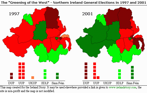
| Election Results 2001 NEW! | Two-in-one map comparing the result of the 2001 General Election in Northern Ireland with that of 1997. Colour-coded to show who won each seat, along with a breakdown of seats. [25kB] |
| General | |
| Ireland Today NEW! | An improved map of Ireland in 2001 showing all towns with over 7000 inhabitants and all the counties. Gives a much larger set of towns than the old map did. [23kB] |
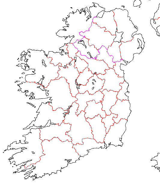
| Provinces | Map showing counties that make up the 4 provinces of Ireland. [14kB] |
| Blank Map of Ireland | A blank map of Ireland showing the coast and county boundaries. Use this if you want to make your own maps. [11kB] |
| Electoral Maps and Charts | |
| Dail Eireann Constituencies | Map showing the Daíl Eireann electoral constituencies in the Republic of Ireland as of the 1997 election. [18kB] |
| European Union Constituencies | Map showing the European Union electoral constituencies in Ireland, as at the 1999 election. [11kB] |
| Northern Ireland Constituencies | Map showing the electoral constituencies in Northern Ireland as used in the overall UK Parliament elections and the new Northern Ireland Assembly elections, as at the 1998 Assembly election. [13kB] |
| June 1998 Northern Ireland Assembly Election Results | Graphic showing the number of seats allocated to each party at the June 1998 Northern Ireland Assembly election. [8kB] |
| Northern Ireland voting trends 1981 to 1998 | Graph showing the proportion of votes allocated to the top 4 parties in successive elections in Northern Ireland from 1981 to 1998. [7kB] |
| Election Results 2001 NEW! | Two-in-one map comparing the result of the 2001 General Election in Northern Ireland with that of 1997. Colour-coded to show who won each seat, along with a breakdown of seats. [25kB] |
| Religious Demography | |
| Protestants in Ireland, 1861 and 1991 | Two-in-one colour-coded map showing the change in the distribution of Protestants in Ireland between 1861 and 1991. [13kB] |
| Declining Protestant population in the Irish Republic 1891 to 1991 | Graph showing the proportion of the population of the Irish Republic who were Protestant in censuses in the period 1891 to 1991. [7kB] |
| Protestants
in Northern Ireland 1991 |
Colour-coded map showing the proportion of each of Northern Ireland's Local Government Districts that is Protestant, 1991. [11kB] |
| Religious
Distribution in Belfast 1991 |
Colour-coded map showing the proportion of each of Belfast's electoral wards that is Roman Catholic, 1991. [98kB] |
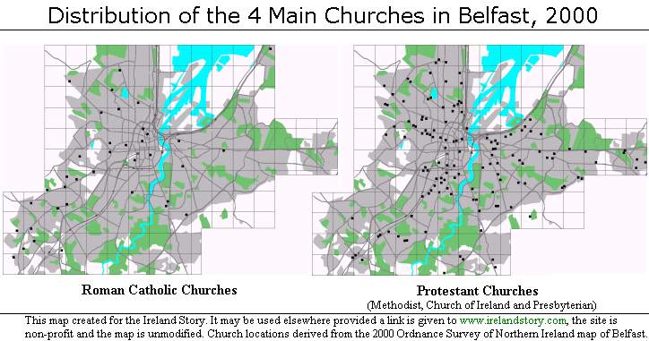
| Distribution in Churches in Belfast, 2000 NEW! | Two-in-one map showing the distribution of (the 3 main) Protestant churches and Roman Catholic churches in Belfast, 2000. [59kB] |
| Religious
Distribution in Derry City 1991 |
Colour-coded map showing the proportion of each of Derry's electoral wards that is Roman Catholic, 1991. [34kB] |
| Portadown Garvaghy Area | Map of the route of the Drumcree Orange parade and the Garvaghy Road area of Portadown, county Armagh. Also shows the area that is predominantly Roman Catholic. [19kB] |
| Administration | |
| Republic of Ireland Administrative Divisions | Map showing the administrative (local government) divisions in the Republic of Ireland. (A key to the numbers on the map is given in Appendix A below.) [11kB] |
| Northern Ireland Administrative Divisions | Map showing the administrative (local government) divisions in Northern Ireland. (A key to the numbers on the map is given in Appendix B below.) [10kB] |
| Population Distribution and Towns | |
| Population Density | Colour-coded map showing the population density in each of Ireland's counties 1992 to 1996. [9kB] More information on settlement in Ireland. |
| Settlement Distribution | Map indicating the locations and sizes of all towns in Ireland with over 5000 inhabitants. [9kB] More information on settlement in Ireland. |
| Northern Ireland Towns | Map showing the main towns in Northern Ireland today. [20kB] |
| Physical
Geography Click here for more information on the physical landscape of Ireland |
|
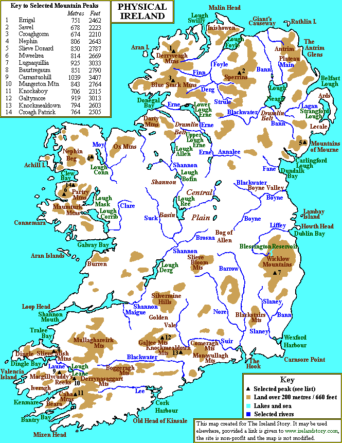
| Ireland Physical NEW! | Shows the main mountain ranges, peaks, rivers, lakes and other physical features in Ireland. [46kB] |
| Agriculture | Map showing the agricultural areas of Ireland [14kB] |
| January Temperatures | Map showing the mean January temperature pattern in Ireland. [17kB] |
| July Temperatures | Map showing the mean July temperature pattern in Ireland. [14kB] |
| Rainfall | Map showing the mean annual rainfall in Ireland. [12kB] |
| Sunshine | Map showing the mean annual hours of sunshine in Ireland. [10kB] |
| Maps
of Counties Note: Due to lack of interest no more county maps are being developed. However, we hope to launch a very large map of Ireland on this site in the coming months. |
|
| Donegal | Map of county Donegal, province of Ulster [ROI], showing main towns, roads and mountains. Scale 5 pixels = 1km. [25kB] |
| Fermanagh | Map of county Fermanagh, province of Ulster [UK], showing main towns, roads and mountains. Scale 5 pixels = 1km. [10kB] |
| Leitrim | Map of county Leitrim, province of Connaught, showing main towns, roads and mountains. Scale 5 pixels = 1km. [10kB] |
| Londonderry | Map of county Londonderry, province of Ulster [UK], showing main towns, roads and mountains. Scale 5 pixels = 1km. [13kB] |
| Tyrone | Map of county Tyrone, province of Ulster [UK], showing main towns, roads and mountains. Scale 5 pixels = 1km. [14kB] |
| Appendix
B: Key to the numbers on the map of Administrative Divisions in Northern Ireland |
||||||||||||||||||||||||||||||||||||||||||||||||||||
|
