| Physical Landforms of Ireland |
| Main Menu \ Geography Menu \ |
| Physical Landforms of Ireland |
| Main Menu \ Geography Menu \ |
| Click here for a detailed physical
map of Ireland [46kB]. The rest of this section details some of the physical
landscape areas that the island is divided into. Ireland can be subdivided into a series of physical regions. (Before reading about the physical regions in Ireland, we recommend you read our brief description of the effects of the glaciation which largely formed these regions): |
|
Beneath it all, Ireland is made up of very old rock. In the Caledonian and Armorican phases of mountain building, much of north-western Europe was folded into mountains of a Himalayan scale. Millions of years of Ice Ages and denudation have reduced these mountains to mere shadows of their former selves. The remnants of this vast mountain chain are to be found in Ireland, Scotland and Scandanavia. In Ireland today, 75% of the land is below 150 metres (492 feet) and the highest peak is only 1,041 metres (3414 feet) high (Carrantuohill, county Kerry). Most of the regions of Ireland were formed by glaciation in the last Ice Age of 20,000 to 10,000 years ago. This map may help you to picture what is being described. If you are interested in the Ice Age, there is a separate account of the Ice Age in the History section. In lowland areas the main effect was the deposition of sheets of drift material. This material, which later became fertile agricultural land, was laid down unevenly, sometimes consisting of gravels and sometimes of clays. The shape that this material was left in varies across the province. Around Dublin, it was shaped into a gently undulating form which is good for agriculture. In the central lowlands the drift material has been shaped by the melting ice in a more irregular, hummocky manner. The drainage is typically confused and many lakes were formed in the hollows. Many of these lakes later turned into the peat bogs that characterise the region today. Where water flowed beneath the retreating ice itself, it formed long, sinewey 'eskers', which can still be seen in the Shannon basin. To the north of the central plain, where the ice melted last, the scraping ice has moulded the landscape into tens of thousands of tightly-packed hillocks called 'drumlins'. These drumlins, which extend from Donegal Bay in the west to to Strangford Lough in the east, are not good agriculturally, and has tended to produce a natural barrier to settlement throughout Irish history. The upland areas were stripped bare of soil by the ice, this being one of the sources of the drift material that was smeared across the lowlands. Where ice formed in mountain-side valleys, great curved basins called 'corries' have been scooped out leaving sharp escarpments where the corries meet. These are particularly noticeable in MacGillicuddy's Reeks in county Kerry. |
What do
you think
of this site?
 This region,
covering counties Donegal and Tyrone, is underlaid by ancient pre-Cambrian rocks which
have been folded into mountains. The Sperrin Mountains and the Donegal Mountains are made
up of hard, quartzitic peaks which were rounded, but not destroyed, by the ice. The Ice
Age stripped the whole region of soil, and today even the valleys have a lack of soil. The
region is thus agriculturally poor, with settlement being limited to the coasts and the
upland areas generally being left to small lakes and bogs. The coasline is typified by
sharp and steep cliffs. Between the Sperrins and Donegal lies the Foyle basin which leads
to the sea at Lough Foyle. The Foyle is made up of numerous rivers (for example, the Derg,
the Mourne, the Strule) which wind their way through Tyrone to the sea.
This region,
covering counties Donegal and Tyrone, is underlaid by ancient pre-Cambrian rocks which
have been folded into mountains. The Sperrin Mountains and the Donegal Mountains are made
up of hard, quartzitic peaks which were rounded, but not destroyed, by the ice. The Ice
Age stripped the whole region of soil, and today even the valleys have a lack of soil. The
region is thus agriculturally poor, with settlement being limited to the coasts and the
upland areas generally being left to small lakes and bogs. The coasline is typified by
sharp and steep cliffs. Between the Sperrins and Donegal lies the Foyle basin which leads
to the sea at Lough Foyle. The Foyle is made up of numerous rivers (for example, the Derg,
the Mourne, the Strule) which wind their way through Tyrone to the sea. The Antrim
plateau in north-western Ireland is an extensive sheet of basalt which rises to over 360
metres (1180 feet). It was formed by a huge horizontal outpouring of lava in the Tertiary
period. Much of this has since been eroded, but enough of the Plateau remains to be a
spectacular area. The hard rock has proved resistant to weathering and the north and
eastern cliffs fall almost directly into the sea. The Antrim Coast Road, built on the
skree slopes between the cliffs and the sea, is a spectacular drive. Inland, nine
east-to-west Glens (valleys) are cut into the Plateau. Agriculture is possible in these
sheltered Glens, but the top of the Plateau remains largely uninhabited. In the west, the
plateau descends beneath Lough Neagh, which is the largest freshwater lake in the British
Isles. There are no steep cliffs on the west side of the Plateau; rather they slowly merge
with the glacial plain of the River Bann.
The Antrim
plateau in north-western Ireland is an extensive sheet of basalt which rises to over 360
metres (1180 feet). It was formed by a huge horizontal outpouring of lava in the Tertiary
period. Much of this has since been eroded, but enough of the Plateau remains to be a
spectacular area. The hard rock has proved resistant to weathering and the north and
eastern cliffs fall almost directly into the sea. The Antrim Coast Road, built on the
skree slopes between the cliffs and the sea, is a spectacular drive. Inland, nine
east-to-west Glens (valleys) are cut into the Plateau. Agriculture is possible in these
sheltered Glens, but the top of the Plateau remains largely uninhabited. In the west, the
plateau descends beneath Lough Neagh, which is the largest freshwater lake in the British
Isles. There are no steep cliffs on the west side of the Plateau; rather they slowly merge
with the glacial plain of the River Bann. The Drumlin Belt consists of tens of thousands of tightly-packed
hillocks, called Drumlins, in a wide belt extending from county Down to Donegal Bay. They
are poor agriculturally, and the hollows between them tend to become water-logged
(although the lower rainfall in the east means that this is more of a problem in the
west). People who come from the Drumlin regions tend to be used to being only able to see
to the next hill and tend to own small farms. The shapes of Drumlins are best seen where
they were flooded by the sea. One of the best places to see this is the west coast of
Strangford Lough (county Down), which is a Drumlin lowland that has been flooded by sea
level rises and now contains dozens of small, rounded islands.
The Drumlin Belt consists of tens of thousands of tightly-packed
hillocks, called Drumlins, in a wide belt extending from county Down to Donegal Bay. They
are poor agriculturally, and the hollows between them tend to become water-logged
(although the lower rainfall in the east means that this is more of a problem in the
west). People who come from the Drumlin regions tend to be used to being only able to see
to the next hill and tend to own small farms. The shapes of Drumlins are best seen where
they were flooded by the sea. One of the best places to see this is the west coast of
Strangford Lough (county Down), which is a Drumlin lowland that has been flooded by sea
level rises and now contains dozens of small, rounded islands. The Western Caledonian Province is a continuation of the
Caledonian North-West; that is hard, rounded, quartzitic peaks underlaid by pre-Cambrian
rocks. Where this hard rock meets the Atlantic Ocean, it has created spectacular sheer
cliffs and fjord-like inlets. Almost all the soil was scraped away in the ice age, and the
region now consists of barren rock, bog and small lakes. There is almost no human
settlement in the interior. Some of the most spectacular areas are the Twelve Pins of
Galway and Croagh Patrick in county Mayo. The region has been split from the Caledonian
North-West by the carboniferous rocks of Donegal Bay which have been eroded more
effectively by the sea.
The Western Caledonian Province is a continuation of the
Caledonian North-West; that is hard, rounded, quartzitic peaks underlaid by pre-Cambrian
rocks. Where this hard rock meets the Atlantic Ocean, it has created spectacular sheer
cliffs and fjord-like inlets. Almost all the soil was scraped away in the ice age, and the
region now consists of barren rock, bog and small lakes. There is almost no human
settlement in the interior. Some of the most spectacular areas are the Twelve Pins of
Galway and Croagh Patrick in county Mayo. The region has been split from the Caledonian
North-West by the carboniferous rocks of Donegal Bay which have been eroded more
effectively by the sea. The
Mourne Mountains of counties Down, Armagh and Louth (which actually consist of the
Mournes, the Carlingford peninsula, Slieve Gullion and Slieve Croob) are an isolated area
of igneous peaks which were strongly glaciated. This has produced sharp, scoured domes
with corries and steep slopes that sweep down to the Irish Sea. The peaks command
panoramic views across the lowlands. This beautiful area has been the inspiration for
poets down the ages.
The
Mourne Mountains of counties Down, Armagh and Louth (which actually consist of the
Mournes, the Carlingford peninsula, Slieve Gullion and Slieve Croob) are an isolated area
of igneous peaks which were strongly glaciated. This has produced sharp, scoured domes
with corries and steep slopes that sweep down to the Irish Sea. The peaks command
panoramic views across the lowlands. This beautiful area has been the inspiration for
poets down the ages.  The Central Plain is a large, low-lying region dominated by the Shannon basin
underlaid by limestone rocks and covered in glacial drift. In the east, where the drift is
around 60m (197 feet) thick, the plain gently undulates, but this becomes thinner and more
chaotic in the west forcing rivers to braid into many channels and myriads of small lakes
and bogs. Occasionally, the drift is so thin that the original limestone land surface
emerges producing the characteristic limestone features. The best example is the Burren in
county Clare. Some regard the Drumlin belt and the southern hill-and-vale province as
extensions of the Central Plain.
The Central Plain is a large, low-lying region dominated by the Shannon basin
underlaid by limestone rocks and covered in glacial drift. In the east, where the drift is
around 60m (197 feet) thick, the plain gently undulates, but this becomes thinner and more
chaotic in the west forcing rivers to braid into many channels and myriads of small lakes
and bogs. Occasionally, the drift is so thin that the original limestone land surface
emerges producing the characteristic limestone features. The best example is the Burren in
county Clare. Some regard the Drumlin belt and the southern hill-and-vale province as
extensions of the Central Plain. The Southern Hill and Vale Province is really an extension of the
Central Plain. Here, the lowland relief has been interrupted by the remnants of ancient
shale plateaux. Where these have been eroded, there are spectacular flat-topped mountains
with steep skree slopes, often capped by wind-swept bogs. In some areas, deep layers of
slate and shale have been folded up through the limestone surface to emerge as mountain
ranges. These mountains rise without warning from the plains, for example Slieve Bloom and
the Galtee mountains.
The Southern Hill and Vale Province is really an extension of the
Central Plain. Here, the lowland relief has been interrupted by the remnants of ancient
shale plateaux. Where these have been eroded, there are spectacular flat-topped mountains
with steep skree slopes, often capped by wind-swept bogs. In some areas, deep layers of
slate and shale have been folded up through the limestone surface to emerge as mountain
ranges. These mountains rise without warning from the plains, for example Slieve Bloom and
the Galtee mountains. The south-eastern Caledonian Province consists of a granite mass which forms
one of the largest continuous mountain regions in Ireland. Originally formed beneath
Ordovician strata, the top layer has now been completely eroded away (except around the
edges). On top, the mass which includes the Wicklow Mountains contains blanket bog which
is suitable for extensive sheep-rearing but is sparsely populated. The edges of the region
contain steep, jagged slopes and is home to Powerscourt Falls, Ireland's tallest waterfall
(106m, 350 feet). In county Wexford, this granite block continues beneath the plain,
emerging occasionally as quartzitic hills.
The south-eastern Caledonian Province consists of a granite mass which forms
one of the largest continuous mountain regions in Ireland. Originally formed beneath
Ordovician strata, the top layer has now been completely eroded away (except around the
edges). On top, the mass which includes the Wicklow Mountains contains blanket bog which
is suitable for extensive sheep-rearing but is sparsely populated. The edges of the region
contain steep, jagged slopes and is home to Powerscourt Falls, Ireland's tallest waterfall
(106m, 350 feet). In county Wexford, this granite block continues beneath the plain,
emerging occasionally as quartzitic hills. In Munster differential erosion has produced parallel ridges of
sandstone mountains with fertile limestone floors between. In Kerry and Cork, glaciation
has accenuated this topography. Good examples of the ridge and valley province are the
Knockmealdown and Comeragh mountains. Where the valleys of west Kerry and Cork have been
flooded by the rising sea, deep rias with mountainous peninsulas have been formed. Rivers
are forced to flow eastwards or westwards along these valleys. The points where they
breach the ridges turn the rivers suddenly south, a characteristic feature of this region
of Ireland.
In Munster differential erosion has produced parallel ridges of
sandstone mountains with fertile limestone floors between. In Kerry and Cork, glaciation
has accenuated this topography. Good examples of the ridge and valley province are the
Knockmealdown and Comeragh mountains. Where the valleys of west Kerry and Cork have been
flooded by the rising sea, deep rias with mountainous peninsulas have been formed. Rivers
are forced to flow eastwards or westwards along these valleys. The points where they
breach the ridges turn the rivers suddenly south, a characteristic feature of this region
of Ireland.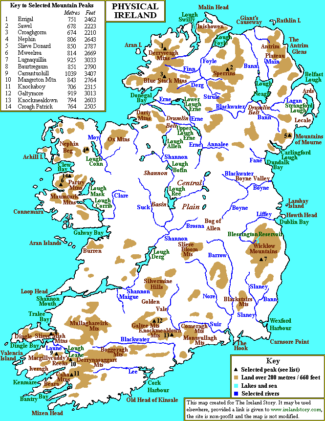