|
Ireland in the Ice Age |
. |
|
|
Ireland in the Ice Age |
. |
|
| You are here: Main Menu \ History Menu \ Pre-Norman History \ | ||
| Back to Menu | Related
Topics: |
|
. |
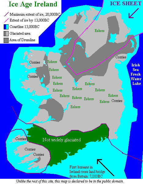
View a summary of this chapter Ireland owes the physcal shape of its landscape almost entirely to the actions of the last Ice Age. The Ice Age left the surface relief much as it now is, except that coastlines have been significantly altered by a subsequent rise of the sea-level caused by the melting of the ice [1].
For reasons not yet fully understood, our planet goes through cycles of warm and cool periods. The last cold spell began around 30,000 years ago and, in Ireland's neighbourhood, caused the Arctic ice to descend from the North Pole towards Europe. By 20,000 years ago Ireland was almost totally covered by a thick ice sheet stretching south-west from Scotland. Throughout this period the build up of ice on land across the world caused the sea level to drop. (See map.) By 20,000 years ago, it had dropped to a level 120 metres (400 feet) below the level it is today. [2] This retreat of the waters meant that Ireland and Britain were once again joined together and joined to continental Europe. On average, 30 to 40km (19 to 25 miles) [3] of sea bed was exposed around the British Isles.
Over the next 2000 years the expansion of the ice slowed, reached equilibrium and then began to retreat. By 15,000 years ago only Ulster was still buried under the dying ice sheet. Although the rising sea levels had begun to flood the lower lands, a land bridge still connected the south-eastern tip of Ireland to south-western England. Trapped between this land bridge, and the ice sheet in the north, the Irish Sea was filled forming a vast freshwater lake. It was at this time that the first plant life returned to reclaim the rocky wilderness that Britain and Ireland had been reduced to. First rugged grasses coated the land and, around 13,000 years ago, the first trees (hardy Junipers) began to grow. Many animals, including the Giant Deer, crossed into Ireland across the land bridge. [2] The low-lying lands around Ireland, Britain and Europe were slowly inundated as the sea rose at a maximum rate of around 6mm/year [3]. The land bridge between Ireland and Britian was finally overwhelmed by the sea 12,000 years ago, flooding the fresh water Irish Sea with salt water (however, short-term fluctuations did cause the land bridge to reappear briefly on several more occasions). One of the most spectacular episodes of this time must surely have been the inundation of the vast Dogger Bank, which lies between Britain and Denmark. Today, the Dogger Bank lies 50 metres (165 feet) below the North Sea, but 10,000 years ago it was covered in coniferous forest inhabited by a variety of animals and possibly stone-age humans. In an indundation that is estimated to have lasted only a few decades, 200,000 km2 (78,000 miles2) of forest was flooded by the rising sea. Had there been any Environmentalists around at the time, this would have been a very traumatic period of history for them. As the ice melted, rivers and lakes formed in the new landforms left by the glaciers. The new river pattern in Ireland had no similarity with what there had been before. Of course, we cannot know what pre-Ice Age Ireland looked like, because the ice destroyed the old landscape so completely. Although all the ice was gone by 10,000 years ago, the sea levels continued to rise reaching a level 2 metres (7 feet) below their current level by 3000 years ago [3]. The weight of the ice (several hundred tonnes per square metre) had pressed the land surface down by several metres. Once gone, the north of the island began to rise again. This process is ongoing: Malin Head, county Donegal, is rising at a rate of 2 to 3mm per year relative to sea level [3]. For all its destruction, the beautiful landscape that the Ice Age left behind played a large part in the the unfolding human history of Ireland. As French geographer Vidal de la Blache commented "man and his environment are more intimate than a snail and his shell". The first humans are thought to have arrived in Ireland 9000 years ago (7000BC). Although, in that time, we have altered Ireland's landscape fundamentally, we have not come close to the same scale of changes that were wrought by the Ice Age. There is a section discussing Ireland's physical landscape in the geography section. |
||
|
. |
| Back to Menu | Related
Topics: |
What do
you think
of this site?
References:
[1] FHA Aalen, writing in the "Atlas of the Irish Rural Landscape", Cork
University Press, 1997, pp4-30
(this breathtaking book is ideal for anybody interested in the development of rural
Ireland - details in
our bookshop).
[2] Walsh DW, "Ireland History in Maps", www.fortunecity.com/bally/kilkenny/2
[3] Dr. R. Devoy. "Sea Level Changes and Ireland", Technology Ireland (Vol. 22,
No. 5)

![Ireland in the Ice Age [24kB]](../../images/historical/spitzbergen.jpg) The photo on the left shows what Ireland
would probably have looked like during the Ice Age. Thick glaciers and ice sheets would
have covered all but the highest peaks and icebergs would have calved into the seas around
the island. Little or no vegetation or animal life would have inhabited Ireland.
The photo on the left shows what Ireland
would probably have looked like during the Ice Age. Thick glaciers and ice sheets would
have covered all but the highest peaks and icebergs would have calved into the seas around
the island. Little or no vegetation or animal life would have inhabited Ireland.