|
|
Status
|
Construction scheme
(future) |
|
Where
|
To form
an inner ring road right around Belfast
City Centre |
|
Total
Length
|
4.6km / 2.9 miles |
|
Dates
|
Under continuous
construction since mid-1970s.
Planned to be completed
by 2018 (as of Nov 2008).
Superseded by Belfast on the Move
project around 2010-12
|
|
Cost
|
? |
|
Map
|
See below. |
|
See
Also
|
Bankmore Link
on this site
|
The Belfast Inner Ring Road, also known as the City
Centre Ring and the Belfast Inner Box,
is being designed to enhance the city centre by
redirecting traffic away from the core city
streets. It will, when completed, provide a
complete two-way orbital route around the city
centre featuring 2 lanes in each direction with
right-turn lanes to minimise interruption to
journey times. Traffic will therefore be
encouraged to "orbit" around the city centre
rather than travelling though it. Note however
that Belfast City Council have in the past been
opposed to the Inner Ring Road (see here).
Although planned and technically under
construction since at least the 1970s, the Inner
Ring has been very slow to be built with only
short sections like Dunbar Link and Carrick Hill
being completed. However it has been included in
the 2005 Belfast Metropolitan Area Plan which
means that it looks likely to be completed by
2015. The BMAP comments that the existing nature
of the road is "disjointed and often expansive"
and commits to making it look more "appropriate to
the streetscape of a central urban area and does
not form a barrier". This probably means making it
appear thinner and encouraging more frontal
development, even if those buildings do not
actually open out onto the road itself.
Almost all of the Inner Ring road will be
constructed by converting, and in some cases
widening, existing streets, many of which are
currently one-way streets. Beginning on Carrick
Hill the road will run north and then turn east
onto Frederick Street past the Interpoint Centre.
It will then cross onto Dunbar Link and head
south, swinging east briefly to pass Custom House
Square and head south along Oxford Street past the
Waterfront Hall. It will then pass onto East
Bridge Street, turn west and go along Cromac
Street. It will then turn right onto a new road,
currently called the Bankmore Link (see link
above), which will link it to Bruce Street near
the Europa Hotel. It will then turn north over
Boyne Bridge, pass straight across Grosvenor Road
and along Durham Street as far as Christ Church,
where it will turn east along College Square North
and finally join Millfield. See the map below.
Other roads, in particular Great Victoria Street
and Victoria Street, will revert to two-way
traffic flows and see significant reductions in
traffic levels. This is intended to assist the
commerical life of these areas and make them more
attractive to pedestrians. Other roads, such as
College Square North, Durham Street and Cromac
Street will require widening. Some elements of the
plan, especially the College Square North ->
Millfield connection, seem very awkward with
right-angle bends that will inevitably disrupt the
flow of traffic, but on the whole the scheme seems
good as it will require very little demolition and
thus bring benefits with relatively little
upheaval and cost.
Map
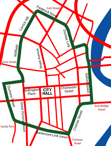
Map showing the route
of the proposed Belfast Inner Ring Road. [Map
based on Google Earth imagery, drawn by Wesley
Johnston]
Updates
26 Jun 2012:
In the four
years since I created this page, the
Department for Regional Development has
brought forward the Belfast on the Move
proposals which aim to give a greater role to
public transport, cyclists and pedestrians in
the City Centre. This has led to a re-think
about the role of the Inner Ring Road, which
it seems will now not be developed in the
conventional way envisaged on this page.
Instead, it looks if the existing Inner Ring
Road will be modified in three phases:
- The
Inner Ring to the west of City Hall
implemented in a slightly different way, as
a combination of one-way and two-way roads.
This was implemented during 2012 and 2013 as
part of the Sustainable
Transport Enabling Measures.
- The missing
southern section, previously planned as
Bankmore Link, will now more likely be
implemented on existing city streets as part
of a separate
scheme.
- The
northern half of the Inner Ring will be
reduced in scale, although will still serve
the same purpose as part of another
separate scheme.
Since it now appears unlikely that the Inner Ring
will be built as envisaged on this page, this page
has now been moved down into "Cancelled Schemes".
9 Jan 2009: Roads
Service issued
a leaflet about this proposal in November
2008. The leaflet reaffirms its committment to
this scheme and sets out its reasons for wanting
to develop the City Centre Ring Road. These
reasons are very much to do with sustainable
transportation:
- to support the objectives of reducing traffic
in the city centre
- giving greater priority to more sustainable
modes of transport such as walking, cycling and
using public transport.
- to significantly reduce traffic levels in the
core of the city centre so that public transport
priority, including rapid transit, can be
maximised.
Roads Service currently
envisage the scheme being implemented "within ten
years". The leaflet also mentions the Bankmore
Link road, which would be needed as part of this
scheme, and which has its
own page.
|
