|
This page is an
archive from the main A26 dualling
page, containing scheme updates from
before December 2016.
Updates
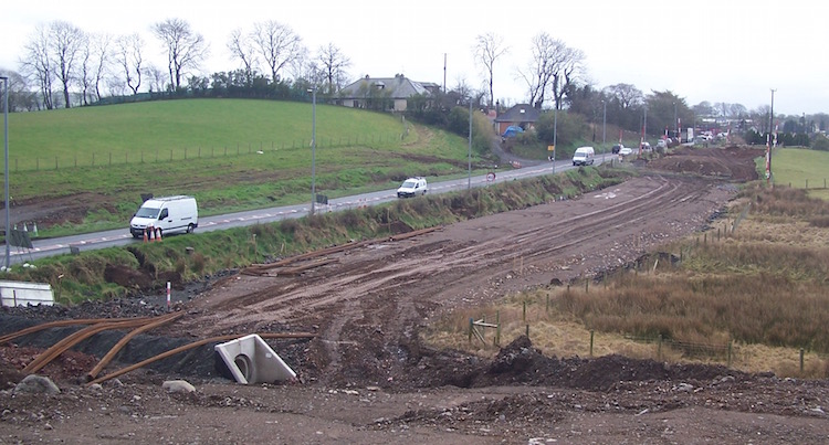
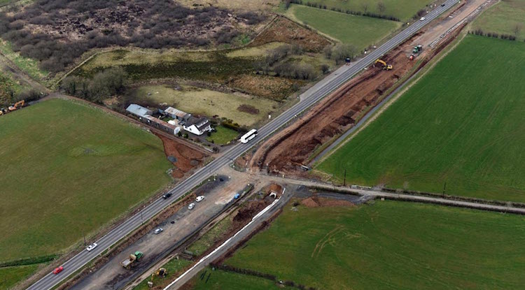
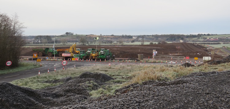
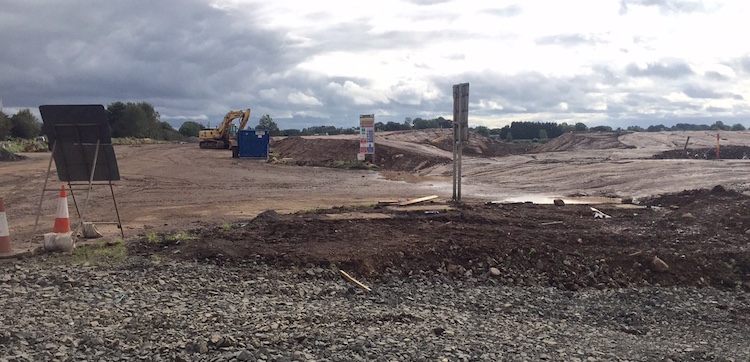
14 Nov 2016: A fortnight ago, on 29
October, I made a video travelling the entire
length of the A26 works, from south to north,
from a car and uploaded it to YouTube
here. It is really good at showing
progress along all parts of the scheme so check
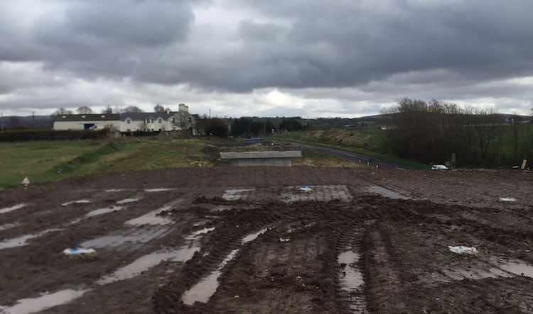
that out. As well as that, the four pictures
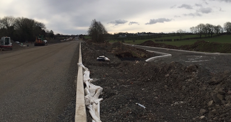
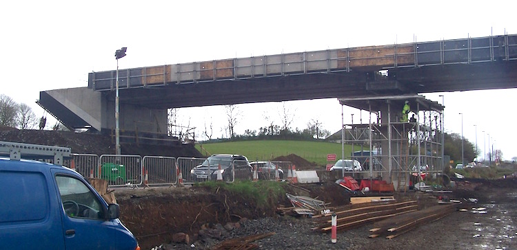
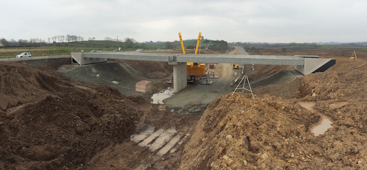
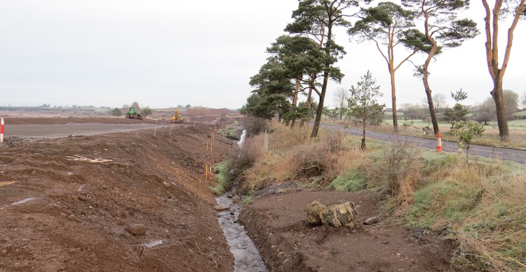
below were taken 8 days ago at Glarryford Cross
by Adrian Martin (thank you). The old, bypassed
stretch of the A26 that goes over Newbridge
Bridge near here now looks eerily quiet (pic 4).
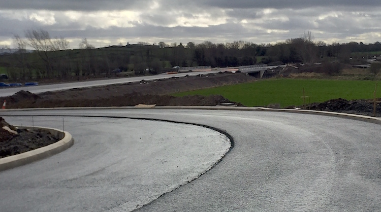
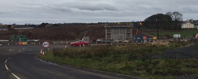
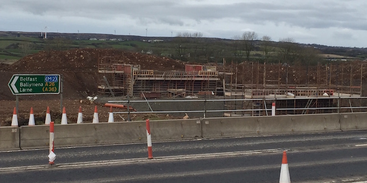
Work on the terminal roundabout at the north end
of the scheme (A44 Drones Road junction) got
underway in October and has progressed very
rapidly. The central island is now largely
complete and traffic is passing on either side
of it. In time terms, the scheme is now only
about 9 months from completion.
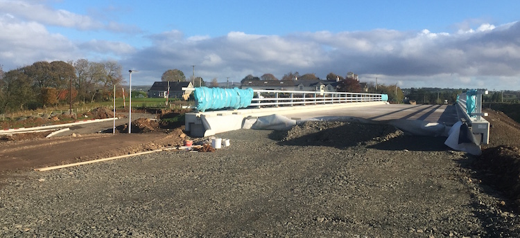
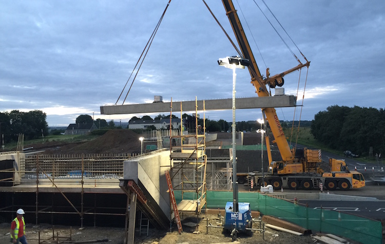
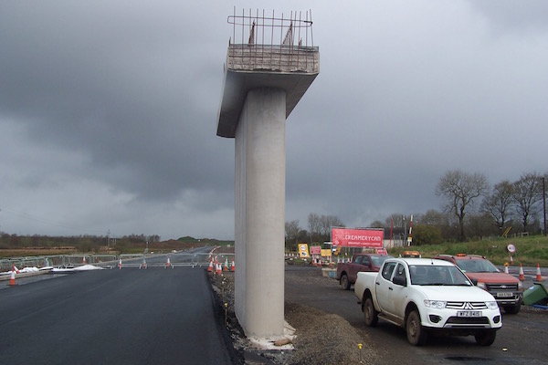
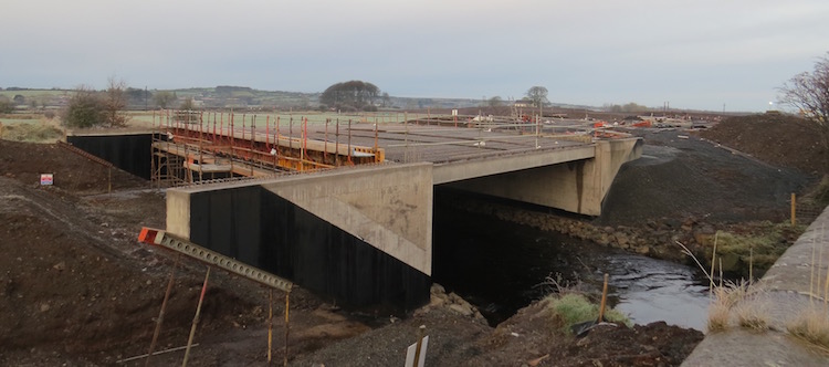
Pic 1: View looking east across the new
Glarryford Cross flyover on 6 Nov 2016, with the
bridge deck now completed, parapets in place
with just the road itself to be built over it.
[Adrian Martin]
Pic 2: View north along the A26 from the
Glarryford Cross flyover on 6 Nov 2016. All
traffic is on the future northbound carriageway
(on the left) while the southbound carriagway
(right) is built. The two curved roads ahead are
the southbound sliproads giving access to the
Glarryford grade-separated junction. [Adrian
Martin]
Pic 3: View south along the A26 from the
Glarryford Cross flyover on 6 Nov 2016. The
roads on the right are the northbound sliproads,
temporarily marked out as a T-junction. The car
on the very left is on the old soutbound
carriageway of the A26, now bypassed. The plan
is that this will be broken up and removed, and
will revert to farmland. [Adrian Martin]
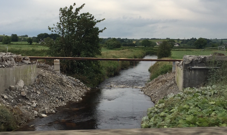
Pic 4: View south across Newbridge Bridge on 6
Nov 2016. This carried the former southbound
carriageway (see the
same view in 2012; this link may not work
on smartphones). This bridge dates from the 19th
century and so will be preserved in place for
historic reasons. The plans show a short access
road in the land immediately ahead to give
access to the bridge from the new road, but this
photographs appears to show it covered over. So
it's not clear if that is still the plan.
[Adrian Martin]
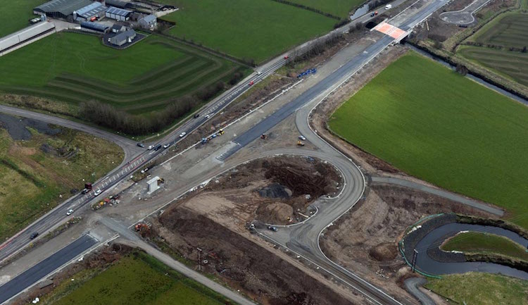
19 Oct 2016: We have been treated to
five lovely aerial shots of the scheme taken
towards the end of September (22nd) which the
contractor sent me and has given me permission
to reproduce here, giving a good view of
progress at five different spots. Thank you! As
well as this the contractor has now published
their latest
newsletter which is full of both updates
and interesting related information. The photos
below are arranged from south to north, and I
have added further commentary in the captions.
In all cases the pictures are viewed looking
generally south-east with the Ballymoney
direction to the bottom left and the Ballymena
direction to the top right.
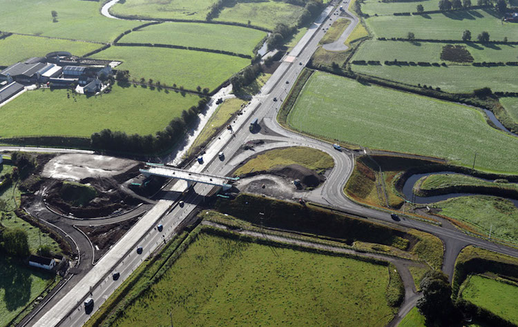
Pic 1: This shot shows the Glarryford
grade-separated juntion on 22 Sep 2016. The
dual-carriageway is very advanced, as is the
west side of the junction (on the right here)
although the sliproads are currently laid out as
a conventional T-junction. Work on the bridge
deck is underway as is work on the east side of
the junction (on the left). At the very top of
the picture you can see the existing layby that
has now been modified to have a single
entrance-exit plus turning circle. Previously it
had an exit at the near end. [FP McCann, with
permission]
Pic 2: This view is taken near the petrol
filling station about 1km north of Glarryford on
22 Sep 2016. At this point the road runs
offline, while a short stretch of the old road
will be converted into a southbound-only access
road parallel to the dual-carriageway. You can
see the offslip and onslip being built at the
left and right respectively, plus a new private
access road serving a house and farm which runs
parallel to that at the left. [FP
McCann, with permission]
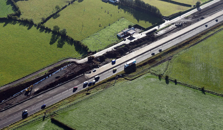
Pic 3: This is the Big Frosses Trees seen on 22
Sep 2016. The new road runs entirely to the east
of the existing road through the trees. None of
the new road is being used right now, so work is
underway on both carriageway simultaneously.
Eventually all traffic will be switched over and
the Big Frosses Trees will be reformatted as a
northbound rest area. [FP McCann, with
permission]
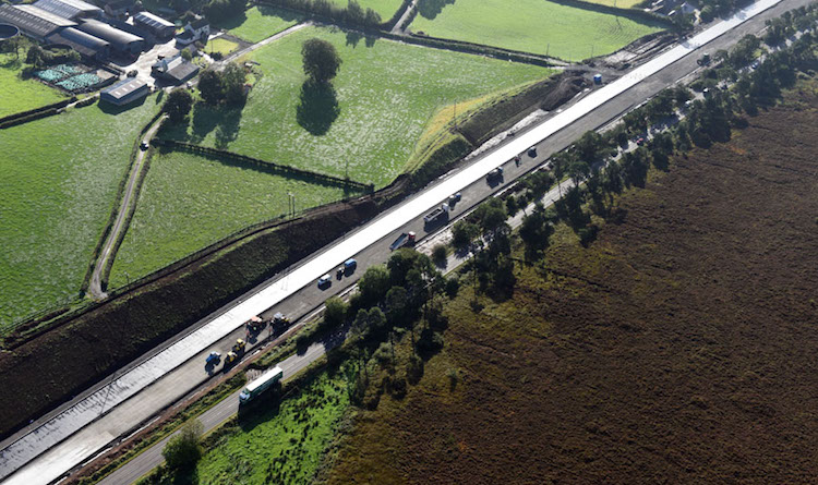
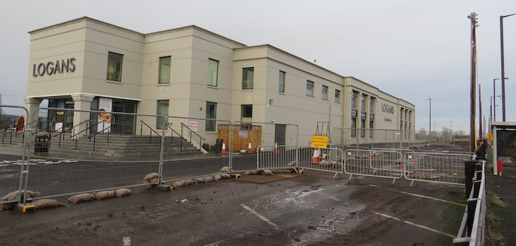
Pic 4: This is the Cloghmills Water Bridge, less
than 1km south of Logans, seen on 22 Sep 2016.
Again the new road is entirely offline here and
the old road will become a southbound-only
access road serving the properties visible here.
The future onslip can be seen taking shape at
the top right. The portion of the new
dual-carriageway at the top right runs right
over an Ice-Age kettle hole, which required
quite a bit of excavation, as evidenced by all
the black ground around it.[FP McCann, with
permission]
Pic 5: Finally, this is the very north end of
the scheme at the Drones Road (Ballycastle) fork
on 22 Sep 2016. A new roundabout is to be built
just to the left of this shot. This ground is so
soft, and roundabouts are so heavy, that the
ground has been "surcharged" with heavy material
now for over a year to force the ground here to
settle. I am told that work on the roundabout
proper finally began in October, suggesting that
the settlement process has now ended. The
roundabout will serve both to control traffic at
this junction and to act as a cue to drivers
that the standard of road is changing. [FP
McCann, with permission]
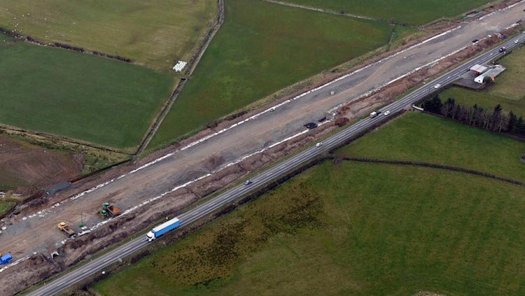
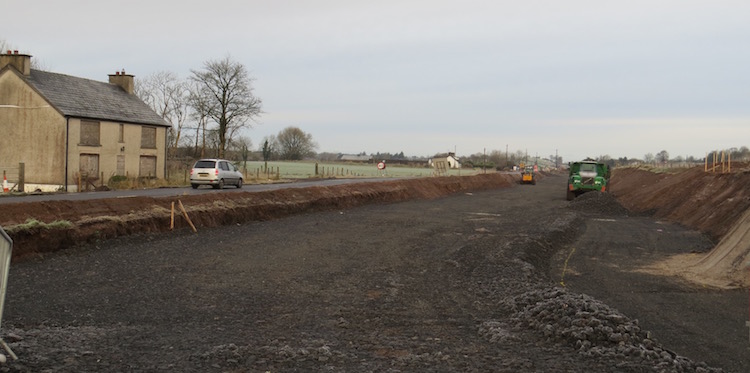
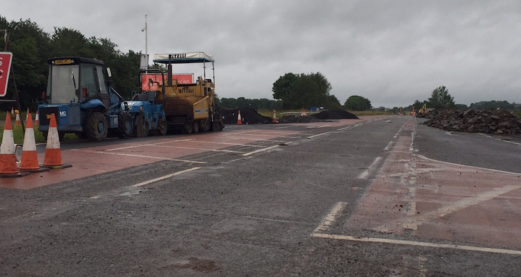
2 Oct 2016: With less than a year to go
lots of progress is evident on the road. The
contractor continues to keep their own
web site well up to date (in fact, this is
about the most well-updated contractor site I've
ever seen for any road scheme here). It tells us
that the "paraslims" were removed from the new
Glarryford flyover on 15 September. These are
the temporary work platforms that were attached
to each side of the bridge to allow workers to
work on the bridge while live traffic passed
beneath. The same thing happened to the farm
accommodation overbridge just to the north on 8
September. At the "big" Frosses Trees, the
location where work was least developed, the
peat removal is now complete and the capping
layer is now in place and the road itself is
being built on top of this and looking much more
advanced now. The picture below is taken on this
stretch looking north, with the "big" Frosses
Trees (the curent A26) visible on the left. (The
location is roughly parallel to here
but on the new line of the road to the right.)
Because the photographer was working on the site
at the time I have left their identity
anonymous, but thank you.
View north along the new A26 adjacent to the
"big" Frosses Trees (on the left). The road is
entirely offline at this point, so the tarmac on
the right is the future southbound carriageway,
while the stones on the left are the future
northbound carriageway. Approx 20 Sep 2016.
[Anonymous contributor]
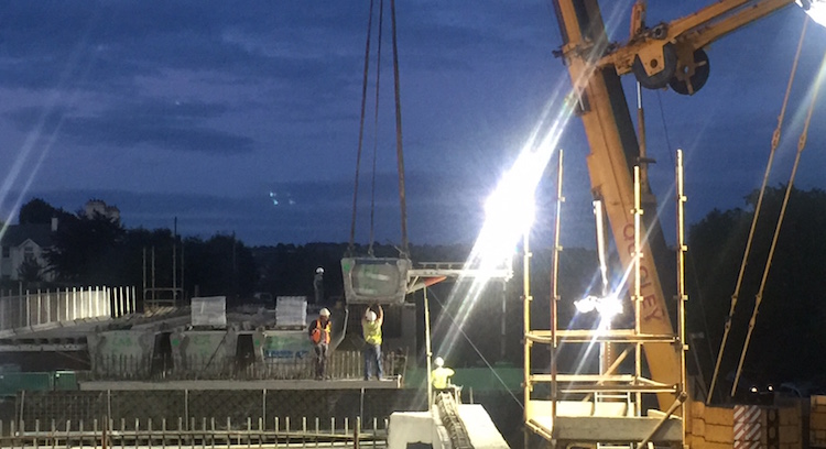
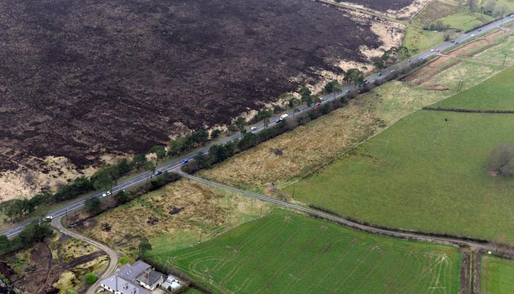
27 Aug 2016: It has been almost three
months since I updated this page, and a huge
amount of progress has happened. For one thing,
three significant sections of new road are now
in use. These are (from south to north) (a)
Glarryford Cross to the Frosses Trees, which is
at least partly offline to the west of the old
road; (b) the section under the new Lisnasoo
Road flyover which opened in 22 July (though
with no access between Lisnasoo Road and the A26
until the end of October) and (c) the section
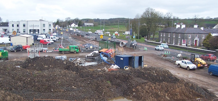
from Logan's Fashions (Drumadoon Road) to the
end of the scheme at the A44 Drones Road
turnoff, which also opened on 22 July. Traffic
is still treating these sections as
single-carriageway however, as work is underway
to build the second carriageway in most or all
of these locations. Work on bridges has also
been progressing well. At least four of the
eight beams needed for the Glarryford Cross
flyover were hoisted into place overnight on 5/6
August - see photos below. This was the last of
the major bridges to get its beams so this is a
milestone. Work is now underway on building the
bridge deck. Just north of there is a farm
accommodation bridge, and the concrete bridge
deck for that bridge was poured on 12 August.
One of the areas where work still has the most
way to go is around the Frosses Trees (where
there is a lot of peat), especially the southern
of the two, the 'Big' Frosses. According to the
contractor, peat removal is now substantially
complete and construction of the 'capping'
layer, on which the road will be built, is
underway. And at Lisnasoo Road, where the A26
has now been shifted to the west, work is
underway to remove the old road entirely, which
will presumably revert to agricultural use or
vegetation. The pictures below were taken by
Adrian Martin on 5 August (thank you!).
Pic 1: Four HGVs lined up on the A26 at
Glarryford Cross, on 5 August 2016. They had
arrived earlier in the day, and parked here.
Each lorry carried a single beam, which I
believe came from Athlone in the Republic of
Ireland [Adrian Martin].
Pic 2: A26 at Glarryford Cross, late on 5 August
2016 as the third beam is lifted into place.
[Adrian Martin].
Pic 3: A26 at Glarryford Cross, late on 5 August
2016. And the fourth beam gets lowered into
place. The four beams visible here complete
eastern of the two spans of the future flyover.
[Adrian Martin].
1 Jun 2016: A much overdue update for
this page, as a lot has been happening. Firstly,
the contractor released an incredible drone
video of the entire scheme in mid April.
Although I tweeted a link to it at the time, I
have realised that I never put a link here on
the web site, so apologies! Although it's now 6
weeks old, it's still well worth watching if you
are any kind of civil engineering enthusiast.
Secondly, the contractor released their first Newsletter in April,
which is worth reading. There's various articles
in it, including information that would be of
interest to geologists. Thirdly, a major change
took place at 11pm on Friday 27 May when all
traffic was switched to the future northbound
carriageway on a 2km stretch from the
southernmost edge of the scheme south of
Glarryford to just before the Big Frosses Trees.
This means that traffic is now using the new
northbound carriageway of the bridge over the
River Clogh, which has been built over the past
year. At Glarryford Cross, which is in the
middle of the newly opened stretch, the rebuilt
Station Road has been re-opened, with all
traffic using what will eventually be the
north-facing sliproads to join the A26. The
Springmount Road is still open, but traffic is
being diverted several hundred metres along the
"old" road, over Newbridge Bridge, before
turning to meet the "new" road at a T-junction.
The switching of traffic should allow work to
begin on the east side of Glarryford Cross which
will allow the bridge itself to be constructed
in due course. The photographs below were all
taken by Adrian Martin on 29 May and show the
new setup. The contractor is maintaining an
up-to-date list of current works on their
site here, so there is no point in me
exhaustively repeating everthing here. However,
it is worth highlighting that the earthworks to
the east of the "Big Frosses", which had barely
begun until now, recommenced in earnest in mid
May. As this was one of the few sections where
work had yet to begin, this is very welcome. The
entire scheme is still on schedule to be
completed by August 2017, which is now only 14
months away.
Pic 1: View south from just south of the Clogh
River on 29 May 2016. All traffic was using this
road until Friday night, and has now been
switched to the new road on the right. A
crossover has been built in the former central
reservation to link the two, because the road
where the photographer is standing is still open
in order to give access to Springmount Road. The
plans show an access point here in the final
design, so this little link road may be
permanent. [Adrian Martin]
Pic 2: View south along the future A26 on 29 May
2016 from the link road shown in Pic 1. All
traffic is now using the future northbound
carriageway, while the photographer is standing
on what will be the future southbound
carriageway. Ahead is the new bridge over the
Clogh River. The central crash barrier has not
yet been built. [Adrian Martin]
Pic 3: View norh from the same location as Pic
2, with all traffic using the future northbound
carriageway, and the photographer again standing
on what will be the future southbound
carriageway. The pillar in the distance will be
the central pier of the Glarryford flyover. On
the left are the future north-facing sliproads,
which is currently marked out as a T-junction
for accessing Station Road (see Pics 7 and 8
below). 29 May 2016. [Adrian Martin]
Pic 4: Moving a few hundred metres north along
the old A26, this is the view south from the
junction with Springmount Road on 29 May 2016.
The area immediately in the foreground will
eventually be buried under the approach
embankment to the Glarryford flyover, while the
stretch of old road beyond will be broken up and
grassed over. All traffic is now using the new
road on the right. [Adrian Martin]
Pic 5: Moving now onto Station Road, this is the
view east from its junction with Kildowney Road
(about 300m from the A26) on 29 May 2016. The
road now climbs up on an embankment towards the
future Glarryford flyover, burying the original
road beneath. It has now been reopened and
looking very smart with its modern crash
barrier, shiny tarmac and what looks like a
continuously-cast kerb. [Adrian Martin]
Pic 6: Moving east along Station Road the left
side of this shot would a nice view across the
Glarryford flyover, were it not for the fact
that it hasn't been built yet! For now all
traffic is being diverted right onto what will
be the future north-facing sliproads, the other
end of which was shown in Pic 3. A forest of
cones, warning signs and heavy duty barriers is
there to prevent errant drivers slithering down
the slope beyond. 29 May 2016. [Adrian Martin]
Pic 7: View east towards the A26 from what will
be the future north-facing sliproads on 29 May
2016. Currently it has been laid out as a
conventional T-junction, but eventually the
onslip will curve left (see Pic 8), and the
offslip curve right. A pair of green direction
signs appear to have been rescued from somewhere
nearby and press-ganged into use here. All
traffic on the A26 ahead is using the northbound
carriageway. The future southbound carriageway
is beyond, though not in use. The central crash
barrier has not yet been built. [Adrian Martin]
Pic 8: Looking slightly left from the same
location as shown in Pic 7, this is what will
evenually be the northbound onslip at
Glarryford, seen on 29 May 2016, tarmacked but
not carrying traffic. The two round holes at the
bottom left likely mark a spot where tarmac
samples have been removed for quality assurance
checks, a routine procedure on new road schemes.
The central pier of the future Glarryford
flyover also appears in this shot. [Adrian
Martin]
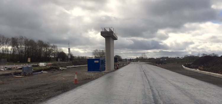
16 Apr 2016: Yesterday I had the
pleasure of a tour of the A26 site facilitated
by the contractor BAM/McCann. I want to
particularly thank Rebecca Henderson and Laura
Carse for spending two hours showing me various
parts of the site, despite pouring rain and an
icy wind, and for explaining many things in more
detail. I also took a lot of photos, 14 of which
I share below. Two weeks ago I put up some
aerial photos (see previous update) that were
supplied by the contractor, and those remain the
best way to get an overview of how the site
looks currently. However, the pictures I'm
sharing in this update focus in on specific
locations which are of interest. The photos are
arranged (as usual) in order from south to
north. The only location I didn't get a photo at
was at the extreme north end of the scheme where
there will be a roundabout at the A44 diverge.
Currently the roundabout site has been
"surcharged". This is done when building on soft
ground - if the road were simply built on top of
the soft ground, it would settle over a period
of months and create bumps and cracks in the
tarmac. Surcharging means building the base of
the roundabout, but then adding hundreds more
tonnes of material on top to make it so heavy
that it speeds up its settlement into the soft
ground. So that is what is happening currently,
but after a suitable length of time (ie once the
settlement rate slows to an acceptable level)
the surcharge material will be removed and the
roundabout will then be constructed. So from the
road, it may just look like a big pile of earth,
but it's actually an essential engineering
process! Finally, FP McCann are keeping the
official web site impressively up to date, so
you can also visit
this page every couple of weeks or so to
see what's happening.
Pic 1: View south over the new Clogh River
bridge south of Glarryford on 15 Apr 2016. The
northbound carriageway, on the right where the
people are, has had all but its final wearing
course of tarmac laid. Northbound traffic is due
to be re-routed over the bridge from the end of
May 2016. [Wesley Johnston]
Pic 2: Moving a few hundred metres further north
to the site of the future overbridge at
Glarryford Cross, this is the view south on 15
Apr 2016 with the northbound off/onslip pair on
the right. Between the on and offslip a third
area of tarmac has been laid, so it looks as if
this is going to temporarily operate as a
conventional T-junction as works progress.
[Wesley Johnston]
Pic 3: Same location as pic 2, but turning 180°
round to look north, this is the central pier of
the future flyover at Glarryford Cross as seen
on 15 Apr 2016. It is now the only one of the
three main flyovers on the scheme that has not
had its beams installed. [Wesley Johnston]
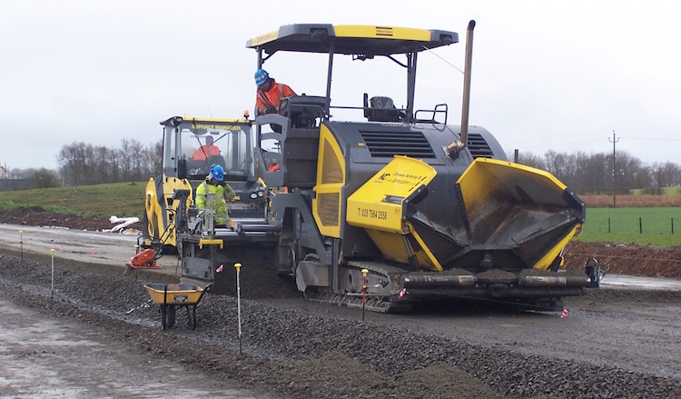
Pic 4: Machine laying a mixture of stones and
cement between Glarryford Cross and the Frosses
Trees on 15 Apr 2016. The road base is formed
from a later of gravel, then a layer of this
cement mixture, followed by several layers of
tarmac. The metal spikes with the plastic caps
are referred to by the machinery to ensure the
surface is level. [Wesley Johnston]
Pic 5: View north from close to the former
petrol station between Glarryford Cross and the
Big Frosses Trees on 15 Apr 2016. At this point
the new road continues almost level into a
cutting while the existing road climbs up on the
right. The road has had its subsurface layer of
stones laid, and is now awaiting further layers
of stone/cement and then tarmac. Earthworks on
the stretch bypassing the Big Frosses trees
began in January, but has had to be suspended
pending drier weather as this is such wet
ground. [Wesley Johnston]
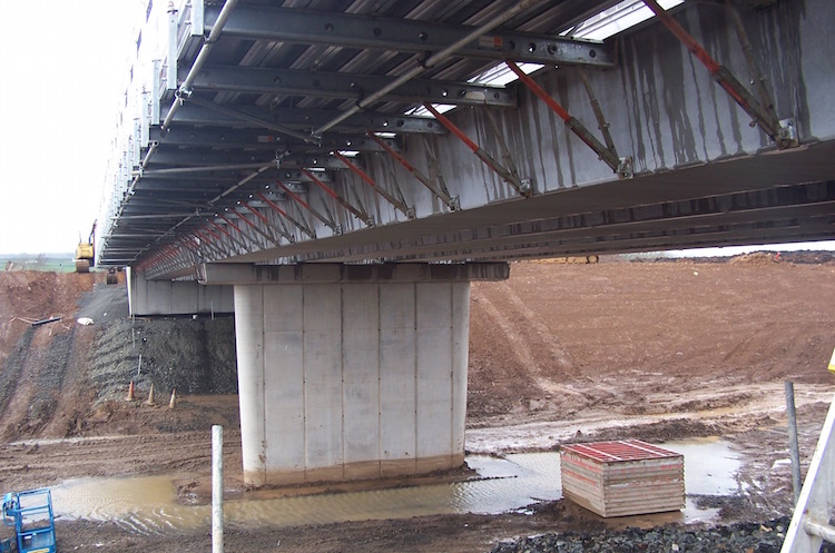
Pic 6: This is the Lisnasoo Road bridge seen
looking west on 15 Apr 2016, with its beams in
place. The metal walkway to the left is
temporary and is used by workers working to
construct the road deck above. The current road
runs left-right a few metres behind the camera
and will be removed once the junction is
completed. [Wesley Johnston]
Pic 7: View under the Lisnasoo Road bridge on 15
Apr 2016. The first is that these four beams are
craned into position. Next, the concrete panels
are laid between them. These panels are called
"permanent formwork" because they are put there
to form the base of the road deck which will be
poured from above, but will remain in situ once
the deck is completed. The beams were made in
Athlone and transported to the site on lorries.
[Wesley Johnston]
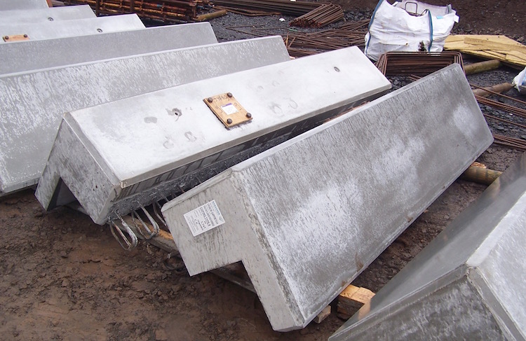
Pic 8: Series of "edge beams" waiting beside
Lisnasoo Road bridge on 15 Apr 2016. These will
form the edge of the bridge, and the bridge
parapet will then be built on top of them. Each
one looked to be about 3 or 4 metres long.
[Wesley Johnston]
Pic 9: View from the same location as pic 6
above (Lisnasoo Road bridge) but turning a
little to the left, this is the view across the
future dual-carriagway towards the future
northbound off/onslip pair on 15 Apr 2016.
Lisnasoo Road was previously a T-junction so the
road will cross over the bridge, and then simply
turn 180° round to join the northbound
carriageway just here. The black pipes are for
drainage along either side of the new
dual-carriageway. [Wesley Johnston]
Pic 10: The Cloghmills Water bridge (between
Lisnasoo Road and Dumadoon Road junctions)
completed on 15 Apr 2016, though the road base
to either side is less advanced. The boulders on
either side of the river channel are to prevent
the river scouring away the bridge abutments
over time - this river can apparently go from
low flow (as seen here) to flood conditions
(completely covering the rocks) in less than 15
minutes. [Wesley Johnston]
Pic 11: The eight bridge beams for the Drumadoon
Road (Logan's) flyover were put into place on
the night of Saturday 9 April. This is the view
looking south on 15 Apr 2016. Note how the
triangular wingwall of the abutment on the left
is suspended in the air, illustrating how the
weight of the wingwall is supported by the front
of the abutment, rather than being borne
directly downwards into its own foundations. (A
metal beam is in place under the wingwall during
construction but will be removed.) When
completed, a grass slope will come up to the
black line, disguising this fact. Workers here
are busy installing steel reinforcement bars
above the bridge beams. When completed, concrete
will be poured into place to form a single, cast
bridge deck. The black material on the concrete
bridge abutment is waterproofing that reduces
the amount of moisture that penetrates the
concrete, increasing its lifespan. [Wesley
Johnston]
Pic 12: First of three pictures taken from the
same spot at the west side of the Drumadoon Road
flyover on 15 Apr 2016. This is the view south
along the line of the future dual-carriageway
from Drumadoon Road flyover on 15 Apr 2016. The
existing road will be rebuilt to form the future
southbound carriageway, while the northbound
carriageway will be built beside it, on the area
of bare soil. [Wesley Johnston]
Pic 13: Turning another 90° right from the
previous shot, ie with Drumadoon Road flyover
behind us, this is the view west along the
future link road which will connect the two
sides of the junction together, seen on 15 Apr
2016. Due to the undulating landscape, the road
goes from the embankment where the photographer
is, straight into a cutting and then joins
Killagan Road roughly where the white/red posts
are. [Wesley Johnston]
Pic 14: Finally, turning another 90° right, this
is the view north along the future
dual-carriageway from Drumadoon Road flyover on
15 Apr 2016. The existing road will be rebuilt
to form the future southbound carriageway, while
the northbound carriageway will be built beside
it, on the area of land that has been taken from
Logan's car park. [Wesley Johnston]
2 Apr 2016: We have just passed the
first anniversary of work commencing on this
scheme, and we are fortunate to have 13 more
photos to show the current state of affairs. One
of the contractors, FP McCann, kindly sent me a
series of aerial photos that were taken about
two weeks ago on 19th March, plus a shot of
Lisnasoo Road bridge with its beams in place
taken four days later. These are further
supplemented by four photos of the Glarryford
Cross junction taken by our very own Adrian
Martin earlier this week, on 27th March. The
photos are all shown below, arranged in order
from south to north. For clarity, it is worth
recapping that the scheme will have three
grade-separated (ie, flyover) junctions along
its length: at Glarryford Cross, at Lisnasoo
Road and at Drumadoon Road (the last being the
site of Logans Fashions). Between Glarryford
Cross and Lisnasoo Road lie the two famous sets
of Frosses Trees. The new dual-carriageway
skirts to the side of these trees, switching
from one side to the other between them. My
grateful thanks to the folks at FP McCann and to
Adrian Martin for making these photos available
to everyone.
Pic 1. View south-east at the very south end of
the scheme, just south of Glarryford Cross on 19
Mar 2016. On the left is the new bridge over the
Clogh River, now structurally completed. A layer
of tarmac has been laid on the future northbound
carriageway and I would anticipate all traffic
will get diverted onto this in the
not-too-distant future. The layby shown already
existed, but has been modified to have a single
entrance/exit and a turning circle since the
original exit is now too close to the offslip to
Glarryford junction. All traffic is currently
using the old "Newbridge Bridge", which will
remain in situ for historical reasons, but will
no longer carry a road. [FP McCann]
Pic 2: View of Glarryford Cross grade-separated
junction on 19 March 2016, also looking
south-east with the Clogh River bridge in the
background. The line of the new dual-carriageway
is very evident, with the current road running
slightly to one side. Also visible is the
central pillar of the future flyover, though
neither of the two side abutments appears to
have been constructed yet. The embankment on the
west side of the road (bottom of the pic) is now
completed and Station Road has been reinstated
on top. Curling away from this towards the main
A26 is the northbound off/on-slip, which is now
also tarmacked. No work has yet taken place on
the eastern side of the junction, presumably
because the current road is in the way. [FP
McCann]
Pic 3: Dropping down to ground level, this is
the view south along the future northbound
carriageway at Glarryford Cross on 27 March
2016, ie 8 days after the previous photo. It
shows the same pillar that is visible in pic 2,
showing that even more tarmac has been laid
since the 19th. Again, I would expect to see all
traffic diverted onto this stretch soon. [Adrian
Martin]
Pic 4: Travelling along Station Road (which runs
off the bottom right of pic 2) and then turning
round, this is the view back up the new
embankment towards the future Glarryford Cross
flyover on 27 March 2016. [Adrian Martin]
Pic 5: Now walking forward from pic 4, up to the
top of the embankment, this is the view across
what will be the future flyover at Glarryford
Cross. The main A26 runs left-right just beyond
the pillar, and the road visible straight ahead
is Springmount Road. The photographer is
standing at the T-junction visible on the
embankment in pic 2. This clearly shows that no
works have yet taken place on the other side of
the flyover. I would expect that to begin by the
summer. 27 March 2016. [Adrian Martin]
Pic 6: Turning 90° to the right from roughly the
same location as pic 5, this is the view south
along what will be the off/on-slip for
northbound traffic on 27 March 2016. The new A26
and the bridge over the Clogh River are visible
in the distance. The tarmacking work here is
very close to completion and looking nice and
fresh. [Adrian Martin]
Pic 7: Back into the air again, and continuing
north, this is the view of the new
dual-carriageway taking shape between Glarryford
Cross (beyond the bottom left) and the Frosses
Trees (beyond the top right) on 19 March 2016,
looking north-west. At this point the new road
is entirely offline (ie, to one side of the
existing road). The white lines are the drainage
channels going in on either side of the new
road. The existing road will remain in-situ
here, to be used for access to houses, farmland
and the filling station on the right. [FP
McCann]
Pic 8: Going further north, this is the Big
Frosses Trees seen looking north-west on 19
March 2016. The new dual-carriageway will bypass
the Big Frosses on the east side (foreground
here) but, although the land has clearly been
fenced off for some months (judging by the
overgrown grass) earthworks have so far not
begun on this stretch. It's interesting, too,
how sparse the Big Frosses looks from the air
compared to how it looks when driving through.
The Big Frosses will remain accessible as a
northbound layby. [FP McCann]
Pic 9: Moving north beyond the Frosses Trees,
this picture was taken four days after the
aerial shots, on 23 March 2016, and shows the
flyover at Lisnasoo Road grade-separated
junction, seen looking south. This flyover is
located off to one side of the existing road
which remains in place on the left of this shot.
The new road will run in a cutting here meaning
that the flyover is roughly at ground level, and
hard to see from the road. The bridge beams had
just been craned into place on the day this
image was taken, making it the most advanced of
the three flyovers. The base of the new
dual-carriageway can be seen heading south,
towards the Frosses Trees, in the background.
[FP McCann]
Pic 10: Moving further north, this is the view
looking south-east of a stretch of the road
between the Lisnasoo Road and Drumadoon Road
(Logans) junctions on 19 March 2016. At this
point the new road swings across the line of the
current road since the new road has much gentler
curves than the old road. This is because it has
to take a more sweeping course through the
landscape to facilitate its "design speed" of
70mph. The grey colour is the stone base for the
road. You can see a digger and bulldozer
cheerfully spreading it. [FP McCann]
Pic 11: Moving slightly further north (bulldozer
on the right also appears in pic 10) this is the
view south-east at the Cloghmills Water on 19
March 2016. The new bridge over the river is
taking shape, though not yet completed. The bit
of the existing road that bypasses the bridge
will remain open as a southbound access road for
the various properties visible here. The area of
brown soil just to the right of centre (with the
large puddles) is the top of a peat-filled Ice
Age kettle
hole, which I assume has had to be
excavated and filled in again to make a sturdy
base for the road. Just one of the challenges
for engineers in a landscape that has been
glaciated! [FP McCann]
Pic 12: Moving slightly further north again,
this is the view north-west towards the Logans
complex and the site of the future Drumadoon
Road grade-separated junction on 19 March 2016.
The future layout is obvious - the two
T-junctions will be modified to become
left-turn-only off- and on-slips, while a
connecting road with a flyover will link the two
sides together. Work seems to be underway on the
abutments for the future bridge, while
substantial earthworks are evident beyond Logans
- these will allow the side road to be curved
further out so as to get a gentler "swing" off
the new road. [FP McCann]
Pic 13: Finally, this is the view north-west at
Ballylig Road, between Drumadoon Road and the
north end of the scheme at Drones Road, on 19
March 2016. At this point, the new road is being
built on top of the old road, so you can see the
future southbound carriageway being built here.
The existing road will then be closed and
rebuilt to form the northbound carriageway. The
road with the white line running beside it at
the bottom of the shot is a new local road that
will give access to properties along here.
Ballylig Road will remain open as a
left-in/left-out only T-junction, as will the
local road on the opposite side of the A26. [FP
McCann]
13 Mar 2016: Three months on since the
last update we have more photos, our thanks once
again to Adrian Martin for taking the time to
stop and photograph the scheme! We are fast
approaching the first anniversary of
commencement of the two-and-a-half year project
and there's now a lot for drivers to see. Work
has continued to progress well since the
previous update. The pictures below particularly
focus on the four main bridges on the scheme -
the new bridge over the River Clogh, plus the
flyovers for the three grade-separated junctions
that are being provided on the upgraded road.
Work on all three bridges is progressing well,
with the Clogh River bridge now essentially
completed. Before long I would expect to see
traffic being diverted onto sections of new road
to allow further works on the site of the
existing road. Certainly I would expect to see
traffic using the new River Clogh bridge before
too much more time passes. Meanwhile, some
excellent aerial photos dating from late last
year have been put up on the contractor’s web
site here.
 Pic 1: View north-west on 6 Mar 2016 towards
the northbound lay-by that sits just south of
the Clogh River bridge. This layby already
existed, but the exit at this end has been
replaced with a turning circle so that vehicles
now have to turn round and go back out the
entrance. This is because the original exit now
lies too close to the offslip to the future
Glarryford Cross grade-separated junction, which
is the line of white running left-right beyond
the trees. [Adrian Martin]
Pic 2: On the right is the same lay-by shown in
pic 1, but seen looking the other way, i.e.
south. On the left is the future northbound
carriageway which is now very advanced. It looks
as if tarmac will be the next element to go
down. The new Clogh River bridge is being built
a short distance behind the camera. 6 Mar 2016.
[Adrian Martin]
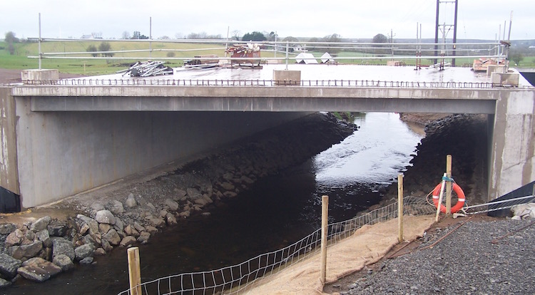
Pic 3: View north across the new Clogh River
bridge on 6 Mar 2016 which now looks completed
with what is likely a red waterproof course on
top of the concrete bridge deck, and railings in
place. Unlike the 1960s bridge it replaces, this
bridge will carry both carriageways of the
upgraded road. The line in the centre of the
bridge is for attaching the central crash
barrier. All traffic is currently using the 19th
century Newbridge Bridge, which is off shot to
the right. That bridge will remain in situ due
to its historical significance, but it will not
be used by traffic. The white line that curves
to the left in the distance is the line of the
northbound offslip to the Glarryford Cross
grade-separated junction which is being built
just ahead. [Adrian Martin]
Pic 4: Moving a bit further north, this is the
view along the northbound offslip to the
Glarryford Cross grade-separated junction on 6
Mar 2016, as seen from the existing road, which
is still in situ here. The northbound onslip
will run just to the right of the offslip and
merge with the new dual-carriageway just to the
right of the shot here. The earthen back that
the slip roads are on is new - previously this
spot was entirely flat and was home to a meander
of the Clogh River, which was diverted at an
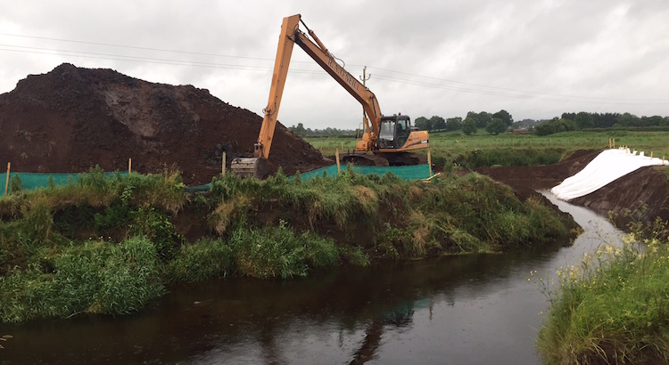
earlier phase of the works. [Adrian Martin]
 Pic 5: Walking up Springmount Road and then
turning round and looking back towards
Glarryford Cross. This is the view west with the
existing A26 running left-right, with north to
the right. It is hard to tell for sure from this
angle, but the large pillar under construction
is likely to be the central pillar of the future
flyover which will connect the two halves of the
future Glarryford Cross grade-separated
junction. The huge approach embankment visible
beyond the pillar has been built up from
scratch. [Adrian Martin]
Pic 6: This is the view of the southbound
onslip at the new Glarryford Cross
grade-separated junction (which curves down from
Springmount Road) on 6 Mar 2016. The future
bridge is to the right of the shot here, which
is looking north-east across the existing road.
Unlike the northbound sliproads, which are being
built on a new purpose-built embankment, the
land on this side slopes up naturally so these
sliproads are close to the original land level.
[Adrian Martin]
 Pic 7: Moving 3km north to the mid point of the
dualling scheme, this is the view west from
Lisnasoo Road on 6 Mar 2016. This will be the
site of the second of three grade-separated
junctions on the scheme. The new road runs
slightly offline here, beyond the current A26
visible in the foreground. This has the
advantage that the bridge for the future
junction can be built without disruption to
existing traffic. The far pillar you can see
being built here is the west end of the future
flyover, while the closer one is either the
central pillar or the eastern one (the angle
makes it hard to tell). The new road is due to
run under this flyover well below the existing
ground level, so we should see more excavations
here in the coming months to lower the ground to
level of the new road. The current stretch of
A26 here, visible in the foreground, will be
broken up and removed once the new road is
completed. [Adrian Martin]
 Pic 8: Finally, moving a further 2km north this
is the site of the future Drumadoon Road
grade-separated junction (known to most as the
Logan’s junction) on 6 Mar 2016. Logan’s is
directly behind the camera, and straight ahead
you can see what will be the central pillar of
the future flyover that will connect the two
sides of the junction together. The existing
road is on the left - this will later be
reconstructed to become the southbound
carriageway. The line of gravel on the right,
behind the metal fences, is the edge of the
future northbound carriageway which will run
where the cylindrical pipe sections are lying.
The flyover will be accessed via two approach
embankments, which have yet to be completed.
[Adrian Martin]
19 Dec 2015: Three months on from the
previous update, we have more pictures - again
from the amazing Adrian Martin who spent a lot
of time photographing all parts of the scheme on
13 December. We're now over a quarter of the way
into the project, and the pictures show that a
lot of progress has been made since September.
At the end of the existing dual-carriageway, the
bridge beams for the new bridge over the Clogh
River are in place and the bridge deck is being
constructed on top. At Glarryford Cross, the
approach embankment for the flyover is well
developed on the western side, and foundations
for the bridge abutments are also evident.
Construction of the road bed around the two sets
of Frosses Trees is also well advanced - this
involves a lot more work than first appears, as
the peat has to be systematically excavated from
the bog, presumably to quite a depth, and
replaced with gravel. Further north at Logans,
the new dual-carriageway will follow the line of
the existing road, and land has been taken on
both sides of the existing road, including quite
a slice of Logans' car park. And at the very
north end, work on the foundations for the
terminating roundabout at the A44 diverge is
also very evident. The 11 pictures below are
arranged in order from south to north. With
grateful thanks on my behalf, and readers'
behalf, to Adrian Martin.
Pic 1: The new bridge over the Clogh River as
seen from the older (and now ironically named)
Newbridge Bridge which used to carry the
southbound A26. The new bridge seen here, which
replaces the 1960s northbound Crankill Bridge,
will carry the entire dual-carriageway.
As seen on 13 Dec 2015 it has its beams in
place, and the road deck is now being cast.
Newbridge Bridge will remain in situ, but not
carrying traffic, due to its historical value in
the local area. [Adrian Martin]
Pic 2: View west across Glarryford Cross on 13
Dec 2015, with the A26 running left-right. The
area of earth above the red sign on the right is
the developing approach embankment which will
lead eventually to the future flyover (see pic 4
below). The bridge will be situated where the
metal fences can be seen to the right of centre
and will run across towards where the
photographer is standing. [Adrian Martin]
Pic 3: View south at Glarryford Cross showing
the foundations for the western side of the
future flyover now in place. The heavy machinery
is on the former northbound carriageway, now
closed. The existing dual-carriageway extended a
short way through Glarryford Cross here but is
being reconstructed as part of the upgrade. 13
Dec 2015. [Adrian Martin]
Pic 4: View east towards Glarryford Cross from
Station Road on 13 Dec 2015. Station Road has
been completely buried by the huge approach
embankment seen here, which leads to the future
flyover, but the road will be rebuilt on top.
The road seen on the left is actually a
recently-built temporary access road that gives
access to Station Road during the upgrade and
will later be removed. [Adrian Martin]
Pic 5: Moving north this is the view north along
the "Wee Frosses Trees" on 13 Dec 2015. The
existing road is on the right - the trees were
originally planted to stabilise the road through
the bog. The new dual-carriageway runs entirely
to the left, leaving the trees in situ - the
road through the Wee Frosses will become a
southbound layby. The road bed on the left was
built by excavating thousands of tonnes of peat,
which is no mean feat. [Adrian Martin]
Pic 6: Moving even further north, this is the
view south from near Lisnasoo Road on 13 Dec
2015. The trucks are located at what will be the
site of the flyover for the Lisnasoo Road
grade-separated junction, one of three along the
scheme. The new road runs to one side of the
current road here, so the bare soil on the right
is actually the line of the future
dual-carriageway. [Adrian Martin]
Pic 7: Further north again, this is the bridge
that will carry the dual-carriageway over the
Cloghmills Water. The bridge abutments were
still being constructed on 13 Dec 2015. This
bridge will carry the entire dual-carriageway
here: the existing road on the right will remain
as a short length of layby for accessing private
properties. Just south of the area shown here
the new road runs directly over a peat-filled
Ice Age kettle
hole, which will present an interesting
challenge for the engineers. [Adrian Martin]
Pic 8: View south from Logan's on 13 Dec 2015.
The area on the right was formerly Logans' car
park, but the new fence on the right shows how
much of this land has been vested to fit a
four-lane dual-carriageway through this
restricted space. The future flyover for the
Drumadoon Road grade-separated junction, the
third of three on the scheme, will be located
about 200m ahead of the photographer here, but
work on this still seems to be at an early
stage. [Adrian Martin]
Pic 9: Same view as previously, but turning 180°
around, this is Logans on 13 Dec 2015. It is
business as usual for this well-regarded
company, but as you can see a good chunk of
their car park is being taken to build the wider
road. The photographer is standing in what will
eventually be the middle of the northbound
carriageway. [Adrian Martin]
Pic 10: Moving even further north beyond Logans
now, this is the view north from near Ballylig
Road on 13 Dec 2015. At this point the road is
being widened entirely on the east side, so the
photographer is on the future southbound
carriageway while the existing A26 (where the
car is) will be subsumed by the northbound
carriageway. The house shown here is not being
demolished but appears to have been derelict before
the work began. [Adrian Martin]
Pic 11: Finally, this is the view north from the
A26/A44
diverge on 13 Dec 2015. The A26 towards
Ballymoney runs out of view to the left of shot,
while the A44 towards Ballycastle runs to the
right (where the white sign is). The T-junction
where the two meet is located just behind the
photographer. The A44 will meet the upgraded A26
at a new roundabout which will be located
directly in front of the photographer - so this
is presumably the foundation work underway for
the future roundabout. (Incidentally, the
aforementioned white sign should be green as the
A44 was made a primary route a couple of decades
ago - the wheels move slowly in the DRD
sometimes! Let's hope the upgraded road features
the correct green signage for the A44.) [Adrian
Martin]
16 Sep 2015: In the month since the
previous update a lot has happened on the
scheme. At Glarryford, the earthworks for the
approach embankments for the new flyover
junction are now very advanced (pics 1, 2), and
the huge scale of them visually dominates the
area when driving through. There is still no
sign of work on the bridge abutments themselves,
but there is still plenty of time for that. Most
of the heavy plant machinery has now been moved
north to Lisnasoo Road (pics 4, 5), where the
next major flyover junction is to be built, so
presumably we are going to be seeing major
earthworks there in the coming weeks. An
accommodation road is being built to provide
alternative access to property along the new
road here. At the Frosses Trees (between
Glarryford and Lisnasoo Road), which the new
road will completely bypass (east of the "Big
Frosses" and west of the "Wee Frosses"), the
foundations of the new road are now very evident
off to one side (pic 3). The two sets of Frosses
Trees will be preserved in the form of laybys,
as it was not possible to upgrade the road
through them. The pictures below were all taken
three days ago by Adrian Martin (thank you once
again) and are arranged in order from south to
north.
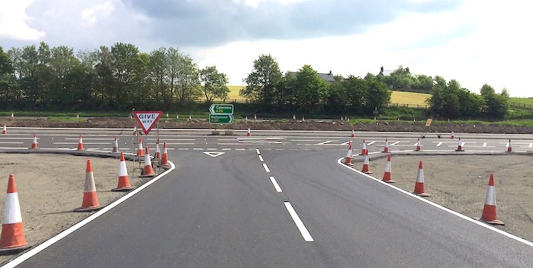
Pic 1: Taken from the B64 Station Road, this is
the view north-east towards Glarryford Cross on
13 Sep 2015. The main A26 is now obscured by the
embankment but it runs left-right in front of
the small white house to the left of centre.
This is the approach embankment to the future
flyover. It looks to me as if the old Station
Road has simply been buried in situ, which will
be something interesting for future generations
to dig up! Compare this to the photo taken at
the same location a month ago in the previous
update below. [Adrian Martin]
Pic 2: It is hard to believe that this is the
view south along the A26 at what was, until
recently, Glarryford Cross. Taken on 13 Sep
2015, the sign in the foreground is actually the
"Give Way" sign sited at the point Station Road
(which ran to the right) met the main northbound
A26 (on which the photographer is standing!).
You can see this sign before the recent works in
Google
Streetview, which will allow you to get
your bearings. The curved embankment ahead is
the future northbound onslip from the flyover
which will eventually pass overhead just a few
metres beyond the sign. [Adrian Martin]
Pic 3: Further north, this is the view
northbound approaching the "Wee Frosses", ie the
shorter of the two stretches of trees, on 13 Sep
2015. The new dual-carriageway will entirely
bypass the Wee Frosses to the left here, and the
foundations for this are already taking shape.
This area is composed of soft peat which
presumably had to be excavated or otherwise
stabilised to be able to take the weight of the
new road without subsiding. [Adrian Martin]
Pic 4: View north along the A26 at Lisnasoo Road
on 13 Sep 2015. This is the site of the second
flyover junction, and large amounts of earth
moving equipment have been moved to this
vicinity in the past week or two, so expect to
see major work here soon. The flyover itself
will be behind the photographer, but the wider
new road will occupy the area in the left
foreground when finished. The small roadway
under construction on the left (under the
striped poles) is an accommodation road which
will eventually give access to fields and houses
since most direct accesses onto the new road
will be closed up for safety reasons. This
accommodation road will join the main road
network at Lisnasoo Road junction. [Adrian
Martin]
Pic 5: At Lisnasoo Road a veritable army of
heavy plant equipment sits waiting for use on 13
Sep 2015. [Adrian Martin]
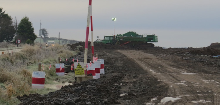
19 Aug 2015: Four months since the
previous update, and five months since the
project began and we have more photos, thanks to
Adrian Martin. These pictures are all taken at
or near Glarryford Cross, a staggered crossroads
at the very south end of the scheme. (This focus
on Glarryford is not to imply that this is the
only place where work is taking place, but
because this is the part of the site Adrian
visited - thank you!). Just to the south-west of
Glarryford Cross is where the current A26
dual-carriageway from Ballymena ends. The two
carriageways crossed over the Clogh river on two
separate bridges, a 1960s one and a 19th century
one (see previous update). All traffic has now
been diverted onto the 19th century bridge,
rather confusingly called Newbridge Bridge, and
the 1960s Crankill Bridge has now been
demolished. Work will presumably start soon on
its replacement, a much wider bridge that will
carry the entire new dual-carriageway. About
half a km north-west of these bridges is
Glarryford Cross itself, which was at the very
end of the old dual-carriageway. Again, all
traffic is now using the southbound carriageway
here. It is to be replaced by a compact
grade-separated junction with an overbridge.
Unfortunately a loop of the Clogh river was in
the way of the approach embankment for the
bridge, so this has now been cut off, as shown
in the photos below. I have included a map below
in case it helps to illustrate what I'm trying
to say here. Finally, earthworks have begun with
at least one of the approach roads, Station
Road, diverted to allow work on the embankment
for the bridge to commence. Regular users of the
route have noted that the past month has seen
significant changes here. In July work was
briefly disrupted when workers
discovered armaments along the site of the
scheme. The pictures below were all taken by
Adrian Martin. The first two were taken on 26
July, and the rest on or near 15 August.
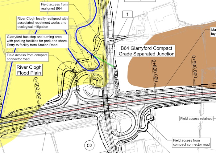
Map of the proposed layout at Glarryford Cross
overlaid on a map of the current arrangement.
The inconvenient loop of the Clogh River is
shown by a blue line, and the cut through the
loop marked in a thin black line. North is to
the bottom right. Roads Service map from here.
Pic 1: The closed northbound carriageway of the
A26 seen from Glarryford Cross on 26 July 2015
with B64 Station Road to the right. All traffic
is using the southbound carriageway, which is
not visible beyond the left of the machinery.
The pile on the right appears to be pieces of
broken-up road surface, perhaps from the
demolished bridge? (see below). [Adrian Martin]
Pic 2: Excavation of the cut through the meander
of the Clogh River underway but not yet
completed on 26 July 2015. [Adrian Martin]
Pic 3: Now moving ahead to 15 August 2015, this
is the view heading north-west from Ballymena
about half a mile south of Glarryford Cross
where all traffic has to switch over to the
southbound carriageway. This is not merely to
convenience the contractor - the bridge for the
northbound carriageway is now gone, which is a
good reason to avoid driving on it! [Adrian
Martin]
Pic 4: View of the recently-demolished 1960s
Crankill Bridge on 15 August 2015, which used to
carry the northbound carriageway. This will be
replaced by a wider, modern structure that will
carry the entire road. Taken from the 19th
century Newbridge Bridge which will remain in
situ, but not in use as a through road, for
historical reasons. The pipe-like structure is
presumably there to accommodate services such as
water or telephone lines that run along the
road. [Adrian Martin]
Pic 5: The "cut" in the loop of the Clogh River
complete and in use on 15 August 2015, with the
original course of the river on the left now
completely filled in. [Adrian Martin]
Pic 6: Switching onto the B64 Station Road, this
is the view north-east towards Glarryford Cross
on 15 August 2015. The road has been diverted,
as the area to the right ahead is to become the
site of the approach embankment for the future
flyover. A lot of trees have been felled here;
the site looks very different than it did a few
months ago when the house on the hill ahead was
barely visible from here. [Adrian Martin]

Pic 7: View north-west, towards Ballymoney,
along what was the northbound carriageway of the
A26, on 15 August 2015. All traffic is using the
southbound carriageway on the right. This was
the spot where the existing dual-carriageway
finally ended and the single-carriageway to
Ballymoney began. The wires with flags are to
warn construction workers of the overhead
cables. [Adrian Martin]
17 Apr 2015: Work got underway properly
on 30th March, following the DRD Minister
officially cutting
the first sod on the scheme on 26 March.
You can see photos from the ceremony on the FP
McCann web site here
(part of the BAM/McCann consortium who are
building the road). The most obvious change from
the point of view of drivers is that the last
half mile or so of the existing dual-carriageway
approaching Glarryford has been coned down to
one lane, and a contra-flow put in, presumably
because this part of the dual-carriageway is
being modified as part of the works. This is
shown in picture 1 below, shared by Adrian
Martin (thank you). At Glarryford crossroads
itself, earth moving equipment was evident on
the day of Adrian's visit (picture 2). This will
be the site of one of the future grade-separated
junctions so is probably related to that. People
who travel this road will know that northbound
traffic uses the modern 1960s Crankill
Bridge, while southbound traffic uses the
original (late 19th century?) Newbridge
Bridge. The plan is to widen
replace Crankill Bridge to carry both
carriageways of the upgraded road. Newbridge
Bridge will then be closed to vehicles, but is
to be preserved in-situ because it has
historical significance (rather like old
Shaw's Bridge in Belfast). With thanks
also to Will Hughes for updates on progress.
View north along the last part of the existing
dual-carriageway approaching Glarryford
crossroads on 5 April 2015. Both carriageways
have been reduce to one lane. Workers are
creating a crossover on the right, presumably to
facilitate a contra-flow. [Adrian Martin]
View north along the existing A26 at the Station
Road (Glarryford) junction on 5 April 2015. This
will be site of a new grade-separated junction,
so expect to see major earthworks taking shape
here in the coming months. [Adrian Martin]
25 Mar 2015: VMS signage on the site
indicates that work proper will get underway on
this scheme on Monday, 30th March. Someone "in
the know" has told me that the preliminary work
that has taken place up until now has included
"cone penetration testing", which would be the
contractor finding out more about the structure
of the ground at various locations. With thanks
to three different people who contacted me with
the information about the VMS signage - much
appreciated. We can look forward to seeing work
progress. Completion is due around August 2017
based on a construction period of 28 months.
11 Mar 2015: According to a Question
for Written Answer in the Assembly last
week, the contractor did indeed begin moving
material and equipment onto the site in February
as reported below. However, construction work
"proper" will not begin until April. With an
estimated construction period of 28 months, this
would now place completion in August 2017. The
written answer also states that the contract
formally began on 19 January 2015.
28 Feb 2015: Since the previous update
there has been no further sign of work, so my
declaration of work being underway in early
February may have been premature! There was a Written
Answer in the Assembly on this topic two
weeks ago. It has emerged that "Following
contract award, a dispute arose between the
contractor and the Department. Despite this,
BAM/McCann remained the most economically
advantageous tenderer." This presumably refers
to a disagreement that has now been resolved,
but it may have delayed the commencement of
scheme which we had previously expected to have
begun by now. The Written Answer says that main
construction works are now due to begin in
"March/April 2015". Finally, it also confirms
that the overall construction cost is still
estimated to be £55m, so whatever the dispute
was it doesn't seem to have affected the cost
much. It will be good to see the project begin.
Ten days ago the same contractor was awarded the
construction contract for the A31
Magherafelt Bypass, which means they'll be
working on both schemes simultaneously.
7 Feb 2015: Thanks to Gregor Kerr who
was driving this way and spotted folks in
high-vis jackets on site, and also reported that
heavy machinery seemed to be arriving on site at
Glarryford on Thursday. This sounds very much
like the contractor (BAM McCann) gearing up to
begin work, which is right on cue. Therefore I
have moved this scheme from "future schemes" to
"under construction". Hurrah! If the
construction takes 28 months as suggested in
October, then we should see completion by June
2017.
28 Jan 2015: Work on this scheme does
not yet seem to have started. I contacted
TransportNI a couple of weeks ago and they told
me that work was actually scheduled to begin in
February 2015 (not December as indicated in the
press release in October), so we can expect it
to begin any time. Over the past day or two
TransportNI has moved
the scheme to the "currently underway"
list, but as I haven't ascertained whether or
not the work is underway I will not move it just
yet! Note that the DRD's web site is giving the
cost as "£50-57m" which differs from what the
DRD Minister said in December 2013 – that the
total cost was "£65m". However, it's possible
that the winning tender came in less than
estimated which could account for this. We will
presumably find out in due course.
31 Oct 2014: Great news for this scheme
- the contractor BAM/McCann consortium was awarded
the construction contract for this scheme on 21
October. This was accompanied by a press
release on 29 October giving more details.
The total value of the contract is given as
£55m, which may not include not borne by the
contractor, eg vesting of land, which is likely
the reason why this is less than the overall
estimated project cost of £65m. Work is likely
to start "by the end of this year", which I
would take to mean December, and will take 28
months, meaning completion is due in April 2017.
Regular users of the road will start to see
evidence of the contractor gearing up for work
in the coming weeks. This will start with the
establishment of site yards at appropriate
points. Vegetation clearance and fencing off of
the vested land has already been carried out
during the year, so the first step will probably
be the commencement of some of the earthworks.
The DRD press release suggests that this
web page will carry updates as work
progresses.
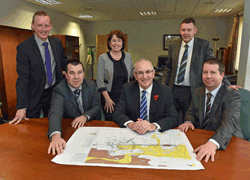
Official DRD photo for the award of contract,
showing the DRD Minister Danny Kennedy (centre)
with Hugh McCann (seated, left) and William
Diver (seated, right) from the appointed
contactor BAM/McCann consortium.
25 Jul 2014: In the previous update I
mentioned how preliminary site works would be
taking place during 2014. People driving past
will have noticed trees disappearing and new
fences being erected. These fences separate the
land vested by the DRD from the land still owned
by private landowners, and are sometimes
replaced by more permanent fences after the
works are complete. The work also includes
archaeological investigations. Doing this now
reduces the changes of high-profile hold-ups,
such as the well-publicised
delays to the A32 Cherrymount Link in
Enniskillen two years ago following the
discovery of a significant crannog. The
archaeological works have been taking place and
a month ago Roads Service (or TransportNI as
they are now called) revealed
that they had found significant artefacts,
including an early Christian souterrain. Here
is an article in the Belfast Telegraph on the
topic. The scheme is still out to tender, with
the contractor currently expected to be
appointed "in the autumn" with work presumably
to start almost straight away.
20 Jan 2014: According
to the DRD, and advance site works
contract is to get underway on this scheme next
week. This work is separate from the main
construction contract which is still in the
early part of the tendering process and won't go
to ground until the autumn. The work involves
three tasks which must take place before the
main work begins. Firstly, they will be
installing fences along all the land that has
now been purchased from landowners along the
route. This will make the boundary of the site
clear to both the landowners and the eventual
contractor. They almost invariably consist of
wooden posts with wire stretched between them. Secondly,
they will be conducting vegetation clearance,
especially the removal of trees and hedgerows
which are problematic to remove later in the
year since there is legislation about disturbing
nesting birds. This means less work for the
eventual contractor who can immediately start
into service diversions and earthworks. Thirdly,
they will be stripping off topsoil, especially
anywhere where archaeology is suspected to
exist. DRD have a statutory duty to investigate
any archaeology that is found or suspected to
exist, and doing this work now reduces the
chances of a later discovery delaying the
scheme. I have not yet marked the scheme as
"underway", as this advance site works contract
is not the main contract and thus can't really
count as the project beginning. As said above,
we can expect this in the autumn.
8 Dec 2013: The scheme has now been put
out to tender (on the DRD
web site and on the EU
tenders web page). This first tender is
actually part one of a two part process, in
which construction firms bid to be included on a
selected list of firms that will be invited to
submit a more detailed bid in the second round.
This is done to prevent a situation where dozens
and dozens of companies who have no chance of
winning the work submit detailed bits and waste
everyone's time. In this first round the
companies have to demonstrate that they have the
means, skill and have realistic expectations on
what is involved to complete the work.
Construction companies have until 28 January
2014 to submit their bids for inclusion. After
that the second part of the tender process - the
more detailed bidding - will be advertised. The
selection of a contractor typically takes about
nine months from now, so we're likely to see the
winner appointed in autumn 2014 with work likely
to begin almost straight away. This is good news
for the construction sector as well as users of
this road. Amended 9 Dec: The DRD
Minister, in a Question
for Written Answer in the Assembly, has
confirmed that the current estimated cost of the
scheme is £65m.
4 Dec 2013: Two days ago Roads Service
finally published the outcome of the Public
Inquiry and their response to it, known as the
Departmental Statement. All the documents can be
accessed
here. While quite a few objections were
made to the scheme, the Inspector made only
minor recommendations which were all accepted in
substance by Roads Service. These generally
related to the impact on individual landowners
near the scheme, and would be important to them,
but do not have a significant impact on the
scheme which will proceed more or less as
planned. The construction tender is due to be
released this month. It normally takes about 9
month from publication of a tender to
construction work commencing, which is in
keeping with Roads Service's own reference to
work beginning in "late 2014". (While everything
has been done above board and within the rules,
I do think it was slightly bad form for the DRD
Minister to have announced that the scheme would
proceed prior to the public inquiry report being
published. While it wouldn't have made any
material difference in this case, the DRD needs
to avoid giving the impression that public
inquiries are mere "rubber stamp" exercises.)
The inspector's report alludes to a plan by
Logan's (a large
retail operation on the route to be
upgraded) to build a park-and-share facility on
their property in apparent competition with
Roads Service's planned similar facility which
would be located nearby on the other side of the
A26. The report was written some months ago,
however, so the situation has probably moved on
since then.
30 Oct 2013: Roads Service have now
confirmed that my predictions in the last update
were pretty close! Subject to the outcome of the
public inquiry, construction will begin in "late
2014" and will last approximately 24 months.
This means that we will see the road completed
late 2016, three years from now. DRD have also
stated that the public inquiry report and their
response to it (the Departmental Statement) will
be published "in the coming weeks". Finally
Arup, the company designing the road for Roads
Service, have put up a fabulous
simulation of a journey northbound along
the finished road on YouTube. Well worth a look,
and enough to whet the appetite of anyone who
endures this road regularly. If you want to see
more detailed plans of the proposed road, click
here.
21 Oct 2013: In the previous update (see
below) I commented that I would be surprised if
this scheme managed to proceed to construction
ahead of the desperately-needed A6 Randalstown
to Castledawson scheme. Well today I am
surprised, because that is exactly what has
happened. Today in
the Assembly funding was announced that
funding was being given to commence construction
of this scheme "in 2014/15", ie it would begin
any time from April 2014 to April 2015, so
between 6 and 18 months from now. It seems
slightly odd to have announced that a scheme is
going to proceed before the outcome of the
public inquiry has even been published, but this
suggests that the inquiry inspector has
recommended that the scheme proceed. I would
anticipate that the public inquiry report and
DRD's response (the "Departmental Statement")
will be published in the near future. After that
the scheme will probably proceed rapidly to
procurement, a process which typically takes
around 9 months, while the Vesting Order (to
acquire the land) will also proceed. So in a
best-case scenario we could be looking at work
commencing in the autumn of 2014. No
timescale has yet been given, but I would expect
that construction of a scheme like this would
probably take roughly two years, perhaps a bit
more. I have also written a piece weighing up
the decision to proceed with this scheme against
the A6 over
on my blog.
16 Sep 2013: There is still no sign of
the publication of the report into the Public
Inquiry that took place in November 2012 - DRD
have now had the report in their possession for
about 4 months. This is not an unusual length of
time by any means, but I would like to think
that we will see it, and their response (the
"Departmental Statement"), published in the
not-too-distant future. There are hints of other
movements behind the scenes. In the last update
I suggested that this scheme might benefit from
the delay to the A5 dualling scheme. In a Written
Answer published today, the DRD Minister
certainly seems to be of this mind. He said "I
have heavily promoted this scheme in the
2014/15 Capital Budget Exercise, and will
continue to do so in the forthcoming October
Monitoring Round, with a view to securing the
funds to allow construction to commence in
2014/15." The DRD don't get money to spend
on whatever major construction schemes they
want. Rather, they have to ask for money for
individual construction projects, and these
compete on merit with bids from other
Departments in the NI Executive, like Education
and Health. The 2013/14 budget is already set
(the A31
Magherafelt Bypass being one of the
beneficiaries) so the 2014/15 budget round is
the next available tranche of money. The DRD
Minister seems to see this scheme as his
priority for this funding round. He also details
some of his apparent struggles with the Finance
Minister in this way: "After initially
declining the meeting [about funding the A26
scheme], I am happy to report that the Finance
Minister has now recognised the importance of
an early discussion on this issue, he has
agreed to a meeting and we are due to meet in
the near future." The DRD Minister had
been specifically asked about the A26 scheme in
this Written Answer, so he did not comment in
this level of detail on other proposed road
schemes. However, and not to diminish the
advantages of this scheme, I would be surprised
if it managed to proceed to construction ahead
of the desperately-needed A6 Randalstown to
Castledawson scheme.
27 May 2013: In the last update I noted
that the Inspector at November's Public Inquiry
was to have submitted her report to the DRD
early in 2013, and according to this
press release this now seems to have
happened. The next stage will be the DRD's
response, which will take the form of a
Departmental Statement, which will take a few
months to analyse and draft. Both it and the
Inspector's report will then be published at
once. It is just as well that the legal process
is progressing, as this scheme seems to be one
of those that *may* benefit from the delay in
the A5 scheme. In the Assembly
last week, the "Roads" Minister said "The
situation is such that we now have to look at
other potential schemes that can be brought
forward. I have indicated that I am doing that
in conjunction with Executive colleagues,
principally the Finance Minister, and we will
continue to do that. The schemes that are most
procurement-ready include the A26
Glarryford scheme,... the A6
[Randalstown to Castledawson] scheme, the
Magherafelt bypass and the A55 [Outer Ring
widening at Knock] scheme in Belfast."
There is, of course, no guarantee that this
scheme will actually get the go-ahead, and of
all those listed it is the furthest from being
able to go to ground, but at least it's being
considered.
11 Feb 2013: The minutes
of a Roads Service meeting held in December, but
only just published indicate that the Inspector
at November's Public Inquiry will submit her
report to the DRD "early in 2013". The DRD will
have to take time to consider this, and will
then publish both the report and their response
(the "Departmental Statement"), presumably in a
few months' time.
12 Dec 2012: The minutes
of a Roads Service meeting held in June, but
only just published, confirm that the estimated
cost of this scheme has now been pinned down at
£61m (as opposed to the range £50m-£70m).
The Public Inquiry happened in November as
planned. I would not expect to hear more on this
for at least a year. The Inspector has to write
her report, and then the DRD has to study it and
respond.
8 Sep 2012: The DRD have announced
that the Public Inquiry will begin at 10am on 5
November 2012, at the Tullyglass
Hotel, Galgorm Road, Ballymena, BT42 1HJ.
The Inspector will be Ms Eileen Brady. I would
urge everyone with an interest in the scheme to
turn up, as this is a crucial opportunity to
have your concerns heard. The recent A5 public
inquiry resulted in dozens and dozens of tweaks
to address the concerns of landowners.
24 Jun 2012: As
expected, the DRD Minister has announced
that a Public Inquiry will be held into this
scheme. It has only attracted 20 objections
during the consultation period that ended in May
2012, but nevertheless Roads Service feel it
appropriate to convene an Inquiry. It will
probably be held in early November. There is
currently no financial commitment to actually
build the scheme, but it is important to keep
progressing the scheme so that it is 'good to
go' if and when money becomes available.
20 Mar 2012: The draft legal documents have
just been published, a good bit later than
anticipated last summer (see previous
update). This includes a summary of the Environmental
Statement (a document that has to be
created to set out the pros and cons of the
scheme); the draft Trunk
Road Order (required to permit Roads
Service to construct a new trunk road); the
draft Vesting
Order (which allows Roads Service to
compel landowners to sell the land
required); and a draft Stopping-Up
Order (which allows Roads Service to
compel some landowners to stop using direct
accesses onto the A26). The first of these
documents contains a map of the road as
currently proposed. A public
exhibition setting out the current
position will be held at the
Tullyglass House Hotel (178 Galgorm Road,
Ballymena, Co Antrim BT42 1HJ) from 2pm to
9pm on 27 and 28 March 2012.
I would urge all those with any interest in the
scheme to turn up and talk to the Roads Service
representatives. Any formal comments must be
received by 11 May 2012. Comparing the preferred
route map from 2008 with the map
published now, the main change is to the
design of the Killagan Road/Drumadoon Road
compact grade separated junction (known to most
people as the location of Logan's Fashions),
where it seems more use will be made of the
existing road network than originally planned.
Presumably there will be a Public Inquiry: at
this stage, a date in the autumn seems
plausible, although nothing has been said
officially. Note that there is currently no
budget allocation to build this scheme - but it
is being progressed through all these design and
legal processes to that it is 'good to go' if
and when money becomes available at a future
date.
4 Jul 2011: The Minister has now
said that the draft legal documents
required to build the road will be published
"later this year", and that a Public Inquiry
will likely be held in Spring 2012. This is the
first official indication that a Public Inquiry
is expected within the next year, although it
was mooted unofficially late last year (see
previous update).
30 Dec 2010: In response
to a written request for an update on this
scheme, the Regional Development Minister gave
an update on progress. He said that "it is
planned to publish the Draft Orders early in
2011/12" (a milestone previously given as "mid
2011"). Construction is still far off, with the
Minister saying only that subject to finance it
"could" commence before 2018. I have been in
indirect contact with a landowner affected by
the scheme who tells me that he was contacted in
mid November to say that the scheme is
progessing as planned with the draft orders due
to be processed by "late spring or early
summer". He was told that while negotiations
have gone well with most landowners, a few
remain unhappy. A public inquiry was mooted for
2012.
2 May 2010: Roads Service have
updated the costs on their web site, with the
cost of the scheme being revised up from £52m to
the range £50m-£70m. There is no change to the
timescale.
22 Feb 2010: In a written
answer in the Assembly, the Regional
Development Minister has said that although this
scheme is in the final stages of the assessment
process, the next milestone (publication of
legal documents) has been pushed back to "mid
2011", more than a year later than he stated in
March 2009 (see below). Although this is a
substantial delay, it will probably make no
material difference to road users since
construction has always been anticipated to be
towards 2018 anyway.
18 Mar 2009: In a written
answer in the Assembly, the Regional
Development Minister has said the Enviromental
Statement and draft orders (such as land
aquisition) will be published during the 2009/10
financial year, ie by April 2010. He also
confirmed that construction is not anticpated
until the "latter part" of the investment
period, ie in the 5-10 year timeframe.
2 Feb 2009: Roads Service released
a leaflet about the scheme in November
2008. It summarises the scheme in its current
form, including a map of the current design. It
notes that "The ‘Preferred Route’ is now
being developed which involves undertaking
statutory procedures for environment,
planning and land acquisition and will lead to
the publication of mandatory Draft Orders and
an Environmental Statement. The ‘Investment
Delivery Plan for Roads’ estimates that this
scheme will be delivered within the period
2013 to 2018." It could thus be quite a
few years before work commences.
11 Aug 2008: The preferred
route has been announced - the entirely online
Blue Route. The scheme also features three
compact grade separated junctions which will
lead to major safety improvements, and probably
accounts for the fact that the price has risen
from £33m in 2006 to £52m today. See above for
more details.
24 Apr 2008: According to an
Assembly written answer, the Department of
Regional Development expects to announce the
preferred route "around mid 2008". The process
to decide between the five route options is
still ongoing.
July 2006: The cost of £22.9m
publicised in 2005 had increased to £33m by the
time this
public consultation was released in July
2006.
Photos
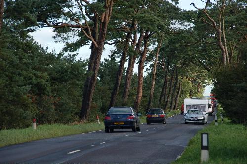
The
beautiful "Frosses Trees" section of the A26
Frosses Road near Clogh Mills where trees are
lined close along each side. Taken looking north
in late August 2006. This stretch will be
preserved as a lay-by. [Photo by Aubrey Dale]
|