|
|
Status
|
Construction scheme
(completed) |
|
Where
|
To dual
about a third of the A26 between
Ballymena and Ballymoney, which forms
part of the main route north from
Belfast via Antrim to Coleraine. |
|
Contractor
|
BAM/McCann
consortium |
|
Total
Length
|
7.0km / 4.4 miles |
|
Dates
|
Frosses Trees planted
to stabilise road - 1839
Scheme proposed in RSTN TP, 2005
Public Information
Day held 15-16 Nov 2006
Preferred route
announced - 11 Aug 2008
Draft legal documents
published - 20 Mar 2012
Public Exhibition - 26-27 Mar 2012
Public Inquiry took place from 5 Nov
2012
Scheme given finance
and approved for construction 21 Oct
2013
Scheme put out to
initial tender - 4 Dec 2013
Advance site works
contract began - 27 Jan 2014
Award of contract to
BAM/McCann consortium - 21 Oct 2014
Official contract start date - 19 Jan
2015
Contractor
mobilisation works began on site - Early
Feb 2015
Official sod-cutting ceremony - 26 Mar
2015
Construction began -
30 Mar 2015
Road fully opened to traffic - 11pm, 6
Jun 2017
Official opening - 12 Jun 2017
(completion changed
from "by 2018" as of Nov 2008, changed
from "early 2010" as of Nov 2006)
|
|
Cost
|
£65m (as of Dec 2013)
(revised from £61m as of June 2012;
revised from £50m-£70m as of April
2010; £52m as of August 2008; itself
revised from £33.4m as of 2006; and
that revised from £22.9m as of 2005)
|
|
Photos
|
See below. |
|
See
Also
|
General
area map
Official
web site for the scheme (Roads
Service)
Design
of the new road - PDF format
A26
Ballymena to Glarryford on this
site
|
Click here to jump
straight down to updates for this scheme.
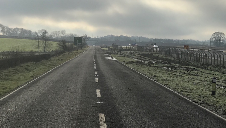
The A26 is the
principal route north from Antrim to Coleraine,
passing Ballymena and Ballymoney on the way. It
is very busy, particularly at peak times and in
the summer when holidaymakers go to the north
coast. If the original
motorway plans of the 1960s had taken
place, this traffic would all be carried by the
M2. However, the M2 was never completed and so
the A26 carries the burden. The dualling of the
section from Antrim to Ballymena was completed
between 1989 and 2001. The section north of
Ballymena, which according to Roads Service
carries 18,000 vehicles per day, has been
dualled as far as Glarryford (about 7km). This
scheme saw the next 7km dualled as far as the
A44 Drones Road junction where all the traffic
for Ballycastle diverts. The map below shows the
section in question in red. The red pins
indicate the locations of grade separated
junctions, while the blue pin is a ground level
roundabout.
The route of the
scheme, announced in August 2008, is essentially
an online upgrade of the existing road, drifting
offline only to bypass the Frosses Trees and to
cross a river near Clogh Mills. The road has
three "compact" grade separated junctions (ie
flyovers) which are, from south to north at:
- B64 Springmount Road/Station Road (near
Glarryford)
- C61 Lisnasoo Road (just north of the Frosses
Trees)
- B93 Killagan Road / B94 Drumadoon Road (at
Logan's Fashions)
Other than these
locations, vehicles are NOT be permitted to turn
right across the central reservation which is
entirely closed. There are ten left-in/left-out
T-junctions along the road to give access to
properties and farms not accessible from the
grade separated junctions. The upgrade
terminated at a new roundabout at the A26/A44
Drones Road junction which was previously a
Y-junction for traffic heading to Ballycastle to
diverge. The Frosses Trees have been preserved
in the form of two laybys adjacent to the
upgraded road. You can see a map of the design
in PDF format by clicking
here. Please tell me if this link
does not work, as TransportNI sometimes change
links. The road has a shared
foot/cycleway along its length.
The purpose of the scheme was to reduce traffic
congestion by increasing the road's
capacity/overtaking opportunities, and improving
safety by reducing conflicting movements and
eliminating head-on overtaking. Arup were
commissioned in April 2006 to develop the
project.
Other Routes Considered
Roads Service
considered five route options
before settling on the Blue Route.
- The Orange Route involves largely widening
60% of the existing road with an offline route
on the northern end to the west of the current
road.
- The Green Route is to widen 80% of the
existing road with 20% of the northern end
offline to the west.
- The Blue Route is to widen the existing road
in its entirety. This option was chosen.
- The Red Route is an almost entirely new
alignment to the east of the current road.
- The Yellow Route is only entirely offline
east of the current road at the south end and
to the west at the north end.
Maps of
these options are available here.
(in the Appendices)
Updates
11 Jun 2017: The road was
fully opened to traffic at around 11pm on 6 June
2017, and by the next morning people were
putting messages on social media praising the
new road and noting how much of a welcome change
it is to be able to drive past Glarryford and
the Frosses Trees at 70mph on such a safe road.
The official opening will take place on
Monday, 12 June. While there are some ongoing
works to complete over the coming weeks, eg
landscaping works, from the point of view of the
travelling public the road is now completed and
I have marked it as such on this web site. Well
done to the contractors, BAM and FP McCann, for
completing such a challenging project to such a
high standard. Travellers will benefit from this
project, which brings Belfast and the North
Coast a bit closer together, for decades to
come. The pictures below were taken by Ryan
Brown (thank you) on the morning of 7 June 2017,
just hours after it opened fully and are
arranged in order from south to north.
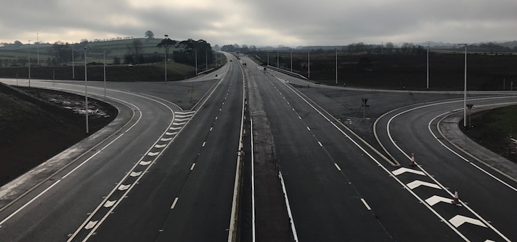
Pic 1: Looking north along the completed A26 at
the south end of the scheme, with the Glaryford
flyover visible ahead, and the southbound onslip
from the Glarryford junction visible on the
right beside the white van. 7 June 2017. [Ryan
Brown]
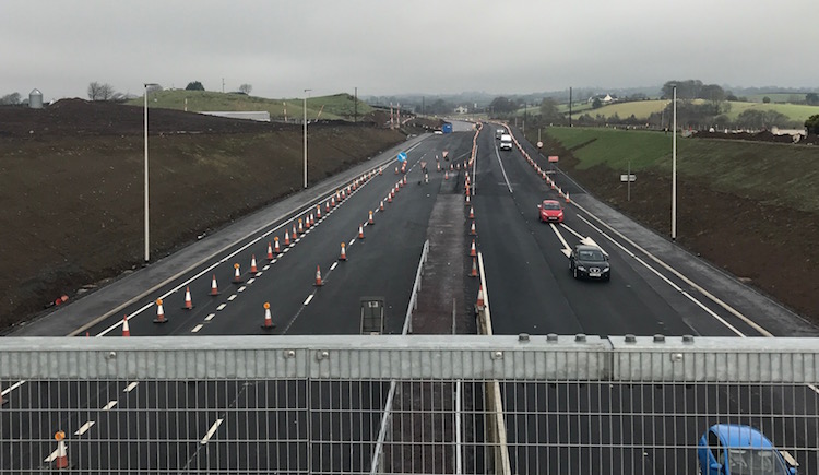
Pic 2: View north along the new A26 on 7 June
2017, about to pass to the right of the "Big"
Frosses Trees, which are still accessible as a
northbound layby. [Ryan Brown]
Pic 3: A bit further north and the new A26
swings across the line of the old road to pass
to the left of the "Wee" Frosses Trees, visible
here on the right. This is accessible as a
southbound layby. On the left is a
left-in/left-out junction providing access to
agricultural property. 7 June 2017. [Ryan Brown]
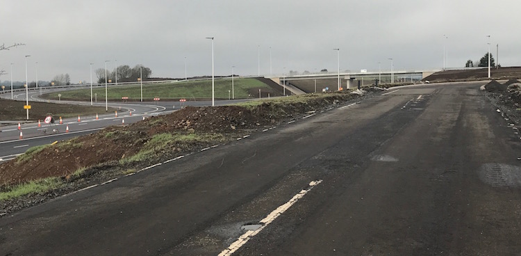
Pic 4: Further north, this is the flyover at
Drumadoon Road junction, with Logan's Fashions
visible just to the right of the sign. Note the
ramp up the embankment on the left, which is a
pedestrian route up onto the link road. Note
also that the embankments are festooned with
saplings, so that in ten years or so this view
will look very different. 7 June 2017. [Ryan
Brown]
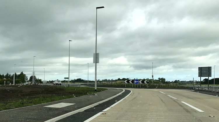
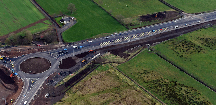
Pic 5: The terminal roundabout at the north end
of the scheme, at the A44 Drones Road
intersection, now complete and in use. 7 June
2017. [Ryan Brown]
14 Apr 2017: The scheme
continues to advance and it is looking as if all
four lanes could well be open by the summer.
Today's update brings you three nice aerial
shots taken about a month ago and published with
permission of the contractor, BAM/McCann, plus
some ground level shots taken by Adrian Martin
at the Glarryford junction. At Glarryford (pics
1-5) the Springmount Road (eastern side of the
junction) re-opened to traffic on 12 April,
meaning that at this junction it is just the
link road over the bridge that needs completed.
The next junction, Lisnasoo Road, is now
complete and in use. At the next junction,
Drumadoon Road (Logans), the connecting road
between the two sides of the junction is open
and the on/offslip on the eastern side has been
constructed, as well as the park-and-share
facility (pic 6). Finally, the last junction,
the roundabout at the A44 diverge, is complete
(pic 7). Between these junctions traffic is
using one carriageway of the new road along the
whole stretch, with some stretches essentially
complete while others still have work to be
done.
Pic 1: Aerial view of Glarryford junction on 6
Mar 2017, looking west with Ballymena to the
left and Ballymoney to the right. At this point
Springmount Road (bottom right) was closed for
realignment, but has since reopened. The main
piece of work remaining is to build the
connecting road over the bridge. You can see
that the on/offslip on the left is temporarily
set up as a standard T-junction. [BAM/McCann,
with permission]
Pic 2: View east along Springmount Road on 7 Apr
2017 with the new junction behind the camera.
The road here is being realigned to meet the new
bridge and opened on 12 April. [Adrian Martin]
Pic 3: View of the new offslip/onslip on the
east side of the Glarryford junction on 7 Apr
2017. This is the loop visible on the right of
picture 1 showing how work has advanced in the
month between the two images. [Adrian Martin]
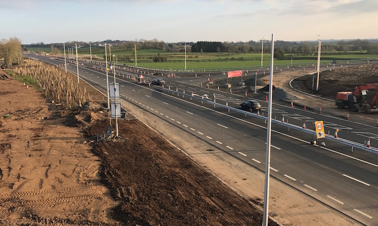
Pic 4: View south from Glarryford junction along
the new dual-carriageway on 7 Apr 2017, which is
still limited to one lane each way though
largely complete. Note the numerous new lighting
columns, yet to receive their heads. [Adrian
Martin]
Pic 5: Same view as pic 4, but looking slightly
more to the left on 7 Apr 2017. This is the view
along the original southbound carriageway of the
A26, with the road surface now removed and
replaced with soil. Only the original footpath
remains in-situ to show its former route. Ahead
can be seen Newbridge Bridge (actually over 100
years old) which is no longer used by vehicles,
but remains in place due to its historic
significance. [Adrian Martin]
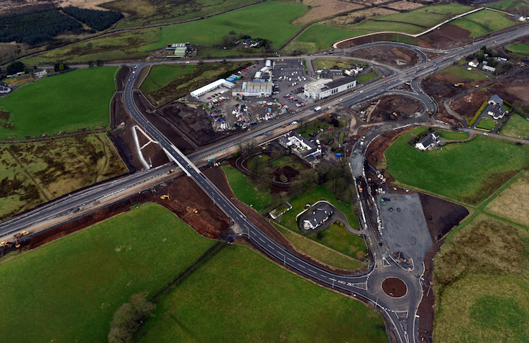
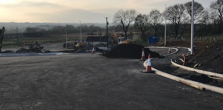
Pic 6: Drumadoon Road junction seen from the air
on 6 Mar 2017, looking west (Ballymena to left,
Ballymoney to right). The bridge and connecting
road is now open and both pairs of sliproads are
being constructed. At the point this image was
taken Killagan Road (far side) was open to
traffic but access from the A26 directly onto
Drumadoon Road (foreground) was shut. I
understand that Drumadoon Road has since
reopened. The large rectangle at the lower right
will be a 100-space park-and-share facility
beside one of only two roundabouts being built
on the scheme. [BAM/McCann, with permission]
Pic 7: The terminus of the scheme at the A44
Drones Road seen on 6 Mar 2017. This view is
looking east with the new dual-carriageway
heading off to the right, the existing
(non-upgraded) A26 to the bottom left and the
A44 to Ballycastle going to the left. The
roundabout has since been completed and fully
opened to traffic. [BAM/McCann, with permission]
8 Feb 2017: This update is
to bring you some lovely photographs that were
taken on 29 January by the wonderful Adrian
Martin - thank you. They show works in two
locations - firstly the area around the existing
filling station between Glarryford and the
Frosses Trees, and then the area around the
Lisnasoo Road grade-separated junction. The
pictures are arranged in order from south to
north.
1. This is the view looking south
along the original A26 from near the petrol
filling station about 800 metres north of
Glarryford junction on 29 Jan 2017. All traffic
is now using the new road to the right, so this
road is deserted, though still technically open
as it’s being retained to provide access to some
private properties. [Adrian Martin]
2. Same location as previous shot,
but turning round 180° to look north. The
filling station is on the right, and ahead you
can see the old road which is now essentially
one-way and accessible by an off-slip and
on-slip (foreground). As well as giving access
to the filling station, it also gives access to
two local access roads. The bridge ahead is an
accommodation farm overbridge. Seen on 29 Jan
2017. [Adrian Martin]
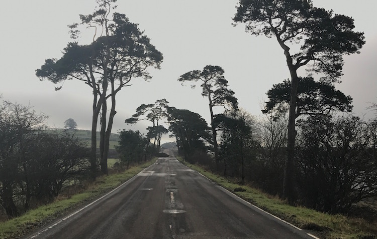
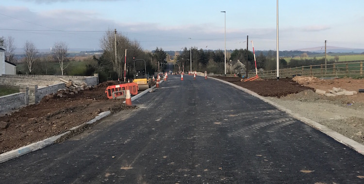
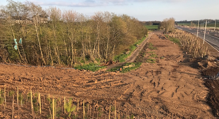
3. Moving north to a point about
100 metres south of Lisnasoo Junction on 29 Jan
2017, this is the view along the old A26 through
the “Wee Frosses Trees”, which are now devoid of
through traffic for the first time in over a
century. This is now a dead-end with a turning
circle at the end of the trees. It will be
accessible from the Lisnasoo Road junction and
will be signed as a rest area so that these
unique, if rather dilapidated, trees can still
be enjoyed. [Adrian Martin]
4. Same location as previous shot,
but turning round 180° to look north. This is
the view of Lisnasoo Road junction on 29 Jan
2017, now open to traffic though limited to one
lane each way. The photographer is on the old
road which is still accessible - see caption to
previous photo for more details. The curved road
on the left is the northbound off/on-slip pair.
[Adrian Martin]
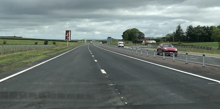
5. This amazing shot is looking
south along the new A26 from Lisnasoo Road
junction on 29 Jan 2017, showing just how
advanced this part of the scheme is with the
final surface down, paint in place and central
crash barrier well advanced. It is hard for me
to believe that less than a year ago I walked
through this excavation ankle deep in mud! You
can see the “Wee Frosses Trees” on the left,
beyond the sliproads, but dwarfed by the new
road that now zooms past behind them. [Adrian
Martin]
6. Finally, this is the same
location as previous shot, but turning round
180° to look north from the Lisnasoo Road
junction on 29 Jan 2017. This is a large cutting
- the land surface was originally at the level
of the photographer. you can still see the line
of the old road which ran along the top of the
cutting to the right, before rejoining the route
of the new dual-carriageway just ahead. [Adrian
Martin]
27 Dec 2016: This update is
to bring you three amazing aerial photographs
which were taken for the contractor (BAM/FP
McCann) on 16 December, and are reproduced here
with their permission - thank you. They show
progress at three of the four junctions on the
scheme: Lisnasoo Road, Drumadoon Road (Logans)
and Drones Road (the terminating roundabout on
the scheme, which opened fully on 19 December).
The captions below give more comments on each
image. In other news, traffic was transferred to
the new northbound lanes from south of
Cloughmills Water to Ballyligg Farm on Wednesday
28th November. Also, Lisnasoo Road junction will
open to traffic on 9 January. On the same date,
Drumadoon Road will be closed to allow the next
phase of works to begin. By the original
timetable there is now only 8 months left of
this 28 month scheme, so we are almost
three-quarters done. Note that the contractor is
maintaining a page
on their web site detailing current
progress, which I encourage you to visit.
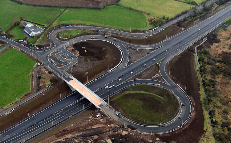
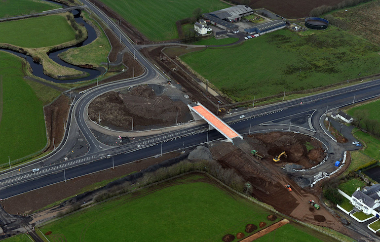
Pic 1: Aerial view of Lisnasoo Road
grade-separated junction on 16 Dec 2016, looking
south -east with Ballymena towards the top
right. This is just north of the Frosses Trees.
Traffic has been using the new cutting for some
time now, with no access to Lisnasoo Road (seen
to the top left) while the sliproads are built.
Work on these looks to be nearing completion
with surfacing laid. The pink colour on the
bridge is probably a waterproof membrane, which
will be covered with tarmac in due course. The
old road ran along the side of the cutting: you
can still see a short stretch to the left of the
frame with a yellow dump-truck parked on it. The
junction is due to open on 9 January 2017. [FP
McCann]
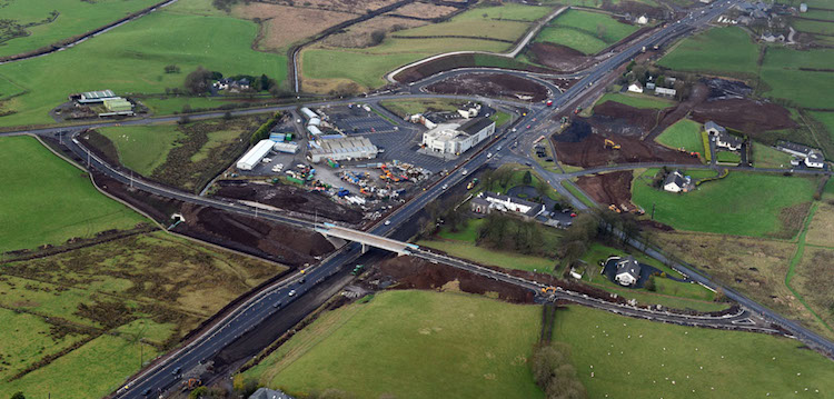
Pic 2: Aerial view of Drumadoon Road
grade-separated junction on 16 Dec 2016, looking
north-west with Ballymena towards the bottom
left. The huge white building in the centre is
Logan’s fashions, while the bridge and new road
that will connect the two sides of the junction
is now in place, though not yet open to traffic.
The two existing side roads will become
left-in/left-out T-junctions, each forming half
of the new junction. To allow this to work
smoothly, they are being realigned onto large
loops. You can see the loop on the left side of
the junction is now in place (just above
Logan’s), but work has just begun on the loop on
the right side of the junction (where the digger
is).
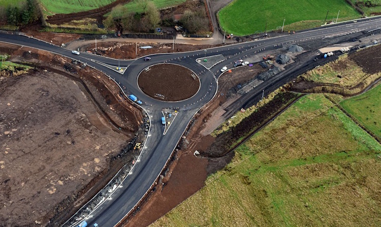
Pic 3: Aerial view of the Drones Road
roundabout, in place and partially in use on 16
Dec 2016. This view is looking east with
Ballymena to the right. This is the northern end
of the upgrade, so the road to the bottom left
is the existing A26 which will remain a
single-carriageway for the foreseeable future.
The road to the top left is the A44 towards
Ballycastle. The dark area to the right of the
roundabout is the old route of the A26, no
longer in use. It will be removed. Until 19
December, when the roundabout opened fully, all
traffic was being diverted up the A44, and
signed back onto the A26 via Kilraughts Road in
Ballymoney, though people with local knowledge
could find ways back onto the A26 much earlier
than this.
For updates prior to December 2016, please see
the archive.
|