|
Most people who live in Northern Ireland are
aware that in the past there were plans for a
much grander system of motorways than that which
exists today. The plans evolved and grew from
the announcement of the first in 1946 through to
the most ambitious period in the late 1960s to
their general abandoment in 1975. A timeline of
motorway schemes exists elsewhere on this
site, so this page exists simply to show
what the plans would have been. The dates below
are those of major plans that were published or
announced: 1946 1956 1964
1969 and then maps for 1975 and 2005.
1946
Plans
The 1946 plan was announced by Major J R
Perceval-Maxwell in the Northern Ireland
Ministry of Commerce. It was to build three
"approach roads" - one from the north to bypass
the Antrim Road; one from the south to bypass
the Lisburn Road; and one from the east to
bypass the Newtownards and Holywood Roads. The
South Approach would have passed south of Lurgan
and terminated between it and Portadown.

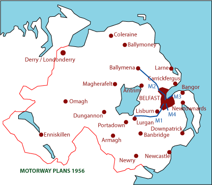
1956 Plans
Announced in June 1956 by Lord Glentoran,
Northern Ireland Minister for Commerce, this
plan extended the 1946 plan by extending the
North Approach as far as Ballymena via Doagh and
re-routing the South Approach to the north of
Lurgan. There would also be a fourth road, the
South-Eastern Approach that would run from the
Ormeau Road near Belfast city centre out to
Carryduff. These roads were named the M1, M2, M3
and M4 clockwise from the south.
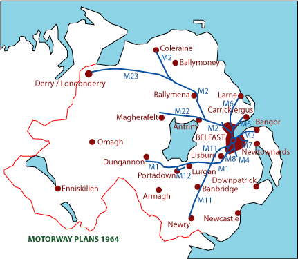
1964 Plans
The 1964 plan
introduced an incredible number of motorway
proposals. It was announced in the House of
Commons by Northern Ireland Minister of Home
Affairs William Craig in February 1964. As you
can see from the map below it was considerable
and included the following elements:
- A Belfast
Urban Motorway encircling the city
centre connecting to the M1, M2, M3 and M4.
- The M1 extended all the way to Dungannon
- The M2 extended to Coleraine via Antrim and
Ballymena
- The M3 extended to Bangor
- The M4 unmodified (Ormeau Road to Carryduff)
- An M5 running from the M2 at Greencastle to
Carrickfergus
- An M6 running from the M5 at Whiteabbey to
Larne
- An M7 running from the M3 at Holywood Arches
to Dundonald
- An M8 connecting the M1 at Lagan Valley Park
to the M4 at Stranmillis.
- An M11 running from the M1 at Finaghy north
round Lisburn, crossing south and going all
the way to Newry.
- An M12 Urban Motorway in Portadown/Lurgan
(Craigavon new town).
- An M22 running from the M2 at Antrim to
Castledawson.
- An M23 running from the M2 near Ballymoney
to Derry.
It was recognised that
this was a long-term plan and that the
completion of the M1 and M2 would take first
priority. It is also interesting that at no
point were motorways considered for much of the
west of the province.
1969 Plans
In 1969 the Belfast
Transportation Plan was announced. It examined
the 1964 proposals and determined which were
realistic propositions for construction before
1986. Anything beyond this date was considered
too far in the future to be seen as concrete
plans. Their final proposals included the
following elements:
- That the M1, M2, M3, M7, M12, M22 and M23
plans should proceed unmodified.
- That the M4 should go in from Carryduff only
as far as Annadale Embankment, as the
extension to Ormeau Road would be too
destructive to the existing city streets.
- That the M5 should go only as far as
Hazelbank with land reserved for a future
extension.
- That the M6 should be abandoned, although
land reserved for possible future
construction.
- That land should be reserved for a possible
extension of the M7 to Newtownards.
- That the M8 should be abandoned as traffic
studies had deemed it unnecessary.
- That the M11 proposal should be abandoned.
- That the Belfast Urban Motorway should
proceed, but the south-eastern portion should
be constructed at-grade with the rest elevated
and grade-separated.

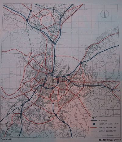
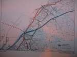
The 1969 report included detailed route maps of
the motorways in the Greater Belfast area. The
overall route map is shown below. To see
detailed versions of different parts of the
network, click the thumbnails below the map.
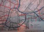 |
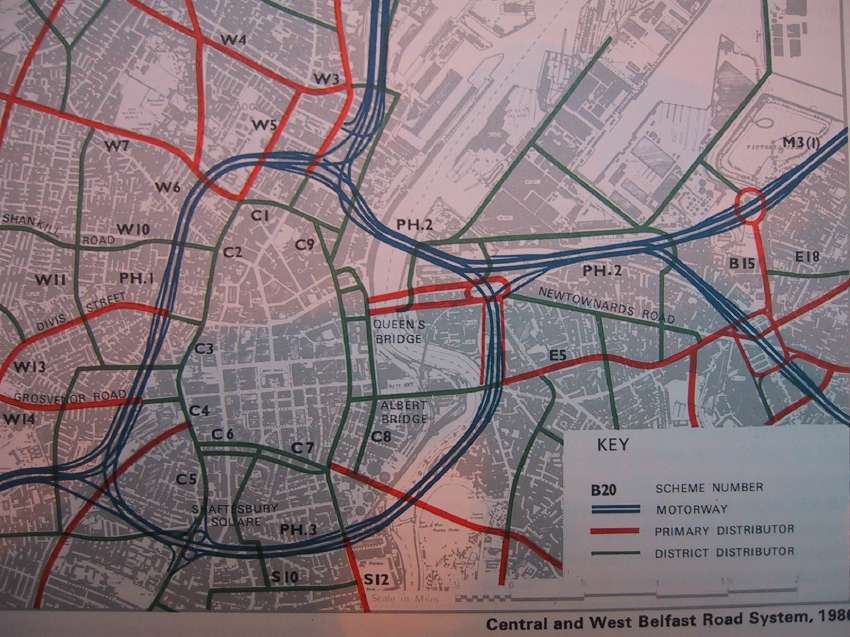
The route of the proposed
Belfast Urban Motorway with the M2 to the
north; M3 to the east and the M7 diverging
to the south east; and the M1 to the west.
Note that, as shown in the map above, the
final portion of the M4 close to the city
centre is no longer planned as it was
deemed too destructive. |
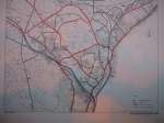
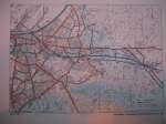 |
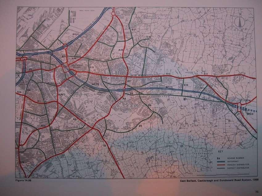
The route of the M7 motorway along the
route of the old railway line through east
Belfast and terminating on the Comber Road
in Dundonald. The dotted line means that
land should be reserved for a future
extension to Newtownards, but this was
never planned in any concrete way. |
 |
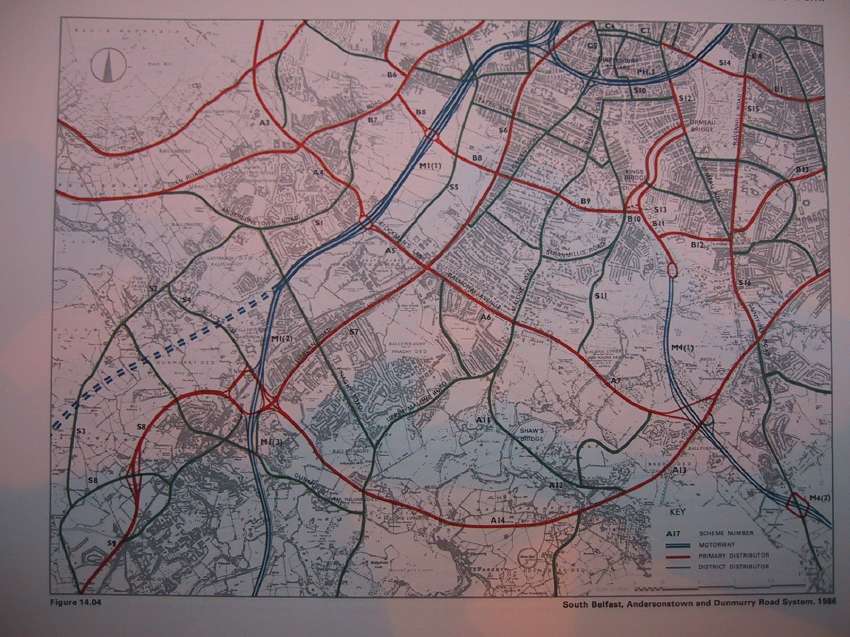
The route of the M1 motorway in south
Belfast, which had been completed by this
time. Note, however, that it shows new
interchanges at Bog Meadows and at Black's
Road. The former was never built, as the
terminus has remained at its original
point on Broadway, but the latter was
opened in 1988 with eastbound-facing
sliproads only. The M4 is also shown with
its proposed terminus at Annadale
Embankment and junctions at Belvoir and
the Saintfield Road. The dotted line on
the left indicates land to be reserved for
possible construction of the M11 if plans
change in the future. This land is now
covered with housing and the line lost. |
 |
The route of the M3 motorway as far as
Cultra. It would have followed the
Sydenham Bypass as far as Knocknagoney and
then turned inland through Redburn Country
Park and passed south of Holywood through
the Ballymenagh area. The portion at
Redburn Park would have been very steep
indeed; comparable to the M2 hill section
at Glengormley. |
 |
The route of the M2 motorway, then built
only from Glengormley to the shore. This
map envisaged an enlarged Sandyknowes
Roundabout and the M2 extending to
Templepatrick. This did happen, but not to
the exact design envisaged here. Note also
the proposed M2 junction 3 at the Antrim
Road, which was never built. Such a
junction would have had such steep slip
roads as to be quite dangerous, and would
have worsened traffic on the M2
considerably. It also shows the M5, which
was opened in 1980. The dotted lines show
land to be reserved for possible
extensions of the M5 and for the M6 to
Larne. Both lines are now abandoned. The
completed A8(M) is also shown, preserving
the proposed original route of the M2 via
Doagh. |
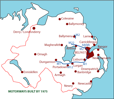
1972 Network
In 1972, while work
was proceeding at a slower pace on the motorway
network, the civil disorder in Northern Ireland
that had begun in 1969 reached such a point that
ministers from London took over administration.
They immediately pulled the plug on the entire
motorway building plan, leaving the system as
shown below:
- The M1 completed.
- The M12, M2 and M22 partly built.
- The M3, M4, M5, M7 and M23 not begun.
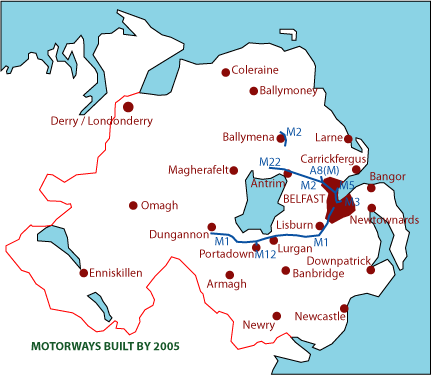
2005
Network
Despite the
cancellation of the motorway project, some work
did proceed after 1972. In the end, the
government permitted the completion of the M5 as
envisaged in the 1969 report. The western
portion of the Belfast Urban Motorway was
finally built in 1981-83 as an at-grade
dual-carriageway (the A12 Westlink). The
northern portion was built in 1995-98 and
labelled the M3. The rest of the scheme was
abandoned. Other parts of the motorway network
are being built, but as dual-carriageways rather
than motorways:
- The M11 route from Lisburn to Newry was
provided in the form of a dual-carriageway
upgrade of the A1 by 2010.
- The M22 route was completed as a new A6
dual-carriageway in 2019.
- The M2 route from Antrim to Ballymena is now
complete as the A26 dual-carriageway.
These schemes are not as
prestigious as motorways, but they give almost
the same benefits and are much cheaper. Perhaps
some day the 1969 proposals will be completed in
spirit.
|