Construction
of a single-carriageway north-south
bypass of Magherafelt
Total
Length
5.9 km (3.7 miles)
Dates
1976 - Scheme proposed
2003 - Regional
Transport Plan commits to proceed
by 2015.
2005 - Included in
the RSTN transport plan.
Aug 2006 -
consultants appointed to progress
scheme.
May 2008 - Statutory
Notices published
Apr/May 2009 - Public
inquiry held
13 Sep 2010 -
Inspectors report published: decision
made to proceed
1 Jul 2013 - Funding
allocated for construction
25 Mar 2014 - Tenders advertised
18 Feb 2015 - Contractor appointed
24 Mar 2015 -
Official "cutting of first sod" ceremony
18 Apr 2015 - Work began
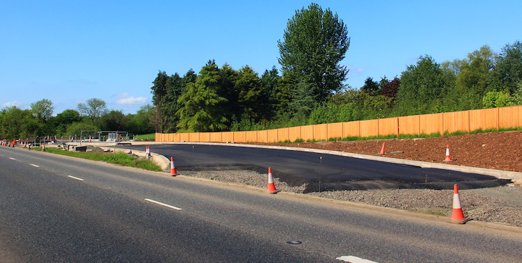
6 Oct 2016 - Scheme opened to the public
(one month ahead of schedule)
Cost
£35m-£45m as of Feb
2014
(revised from £36m as of Feb 2009;
revised from £33m as of May 2008,
revised from £13.1m in July 2006 ,
itself revised from £9.4m as of 2005)
Click
here to jump straight down to updates
for this scheme.
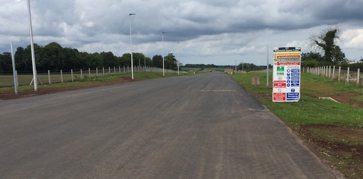
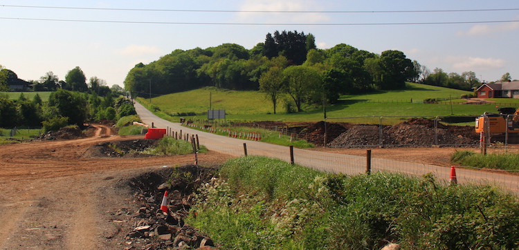
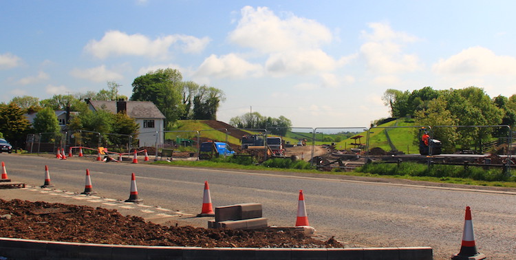
The town of Magherafelt lies on the A31 route
which connects the south west of the province
(Tyrone, Fermanagh) to the north east
(Coleraine, Ballymena etc). It is thus used
quite heavily, with 17,500 vehicles per day in
2009. Traffic currently passes through the town
centre as there is no realistic alternative
route. This scheme will see a single-carriageway
bypass constructed around the eastern edge of
the town connecting Moneymore Road and
Castledawson Road. The old road through
Magherafelt became B40 when the road opened.
The cost of £9.4m publicised in 2005 had
increased to £13m by the time this
public consultation was released in July
2006, and had risen considerably to £33m by May
2008 and £35-45m by Feb 2014. These costs
are partly due to construction inflation but
mainly due to the increasingly ambitious nature
of the design which saw the road taken further
and further out from the urban area and hence
become longer and longer.
Route
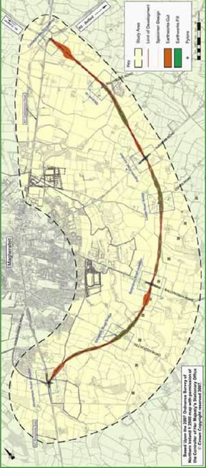
This map, released to the public in January
2008, shows the route of the proposed road
running from the existing Castledawson
roundabout in the north round the east side of
the town. A more detailed map can be found on
pages 6-7 of the Summary
Environmental Impact Statement.
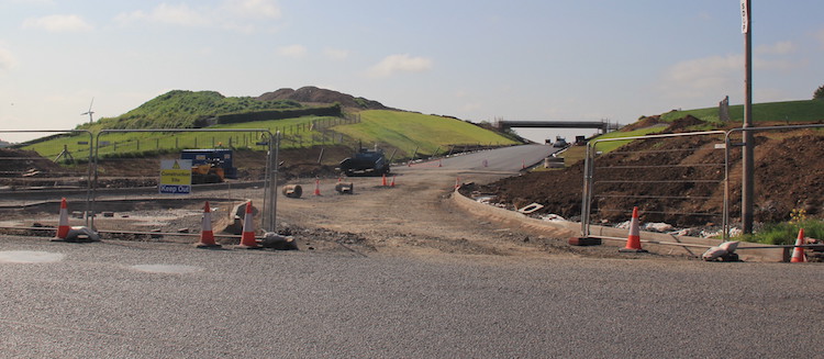
The new road will have four roundabouts with
three stretches of road between them. The road
would have no other junctions between the
roundabouts. The first roundabout is the
existing Castledawson Roundabout on the A6. The
road then continues to a roundabout on Aughrim
Road, then a roundabout on Ballyronan Road and
finally terminates at a new roundabout on the
existing A31 Moneymore Road south of the town at
Coolshinny Road. Bridges will carry the road
over Killyfaddy Road and Loves Road, while
Killyneese Road will pass under the Bypass via a
limited-headroom underpass (ie no lorries). This
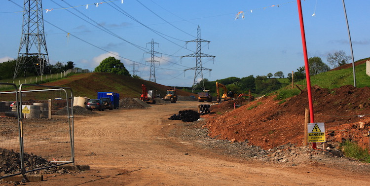
route passes through some very boggy land, which
has likely added considerably to the cost as the
foundations will have be dug quite deep. The
design will feature one or more stretches of 2+1
carriageway (two lanes in one direction, one in
the other).
Earlier Route Options
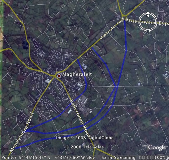
This map (a
screenshot from Google Earth) shows the
approximate routes as proposed in an EARLIER a
leaflet released to the public in October 2007.
It shows the so-called blue
(innermost) route, the purple
(middle) route and the pink
(outer) route. The 2005 Transport Plan proposed
the blue route, which is
identical to a plan first published in 1976,
with the other two options being added during
2007. This screenshot from Google Earth shows
the proposed routes (note again that this is approximate):
Progress
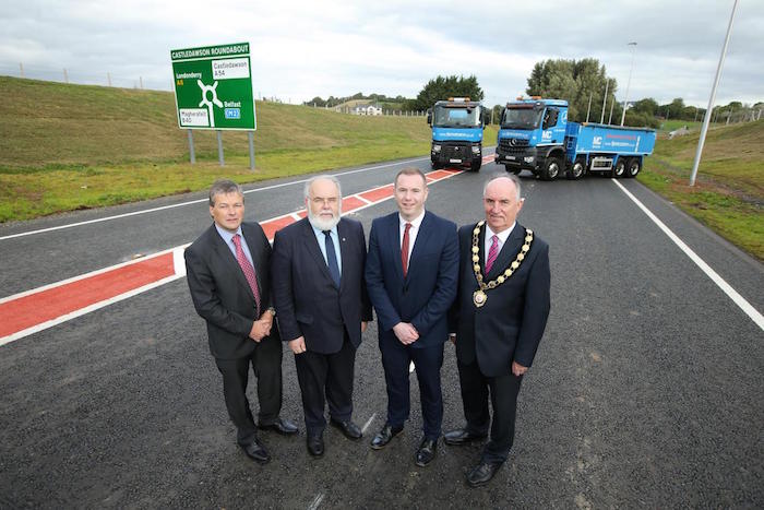
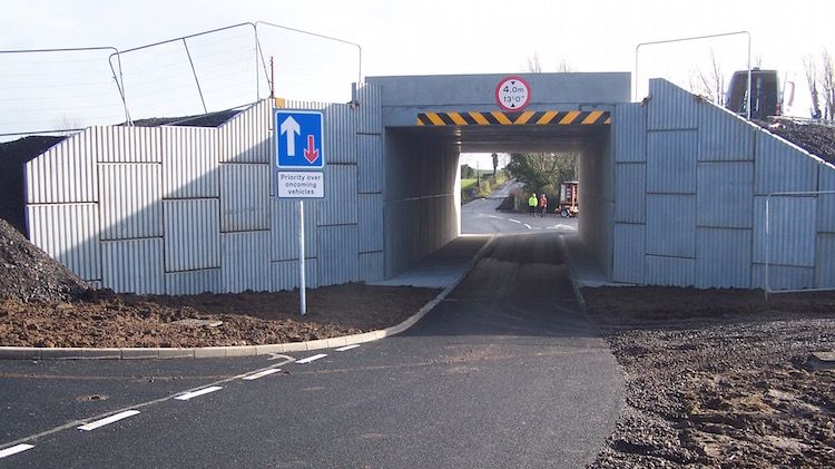
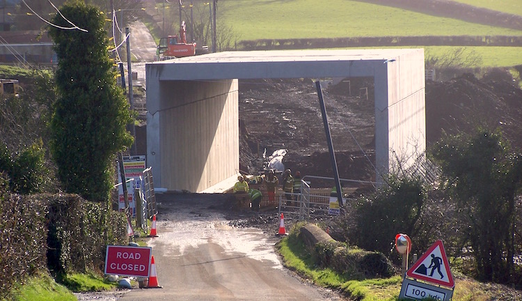
6 Oct 2016: The A31 Magherafelt Bypass
was officially
opened today in a ceremony involving the
Infrastructure Minister Chris Hazzard (see
picture below). One thing that delighted me is
that the official opening really was the
actual opening - in recent years the "official"
opening has often occurred days or even weeks
after the road was actually opened to the
public. Having a genuine opening ceremony was
delightfully reminiscent of the feeling of
forward-looking adventure that road construction
had in the 1960s. The road is predicted to take
about a third of the vehicles out of the town
centre, about 7000 vehicles per day, and
probably an even higher percentage of heavy
goods vehicles. The difference should be
immediately noticeable to residents of
Magherafelt. The Minister commented that road
had been opened "ahead of schedule" and this is
no exaggeration. When the contractor was
appointed in Feburary 2015 the opening was
estimated to be in December 2016, so by that
measure the scheme is about two months ahead of
that schedule and apparently about four weeks
ahead of the more detailed schedule that was
worked out after work began. Congratulations to
the contractor BAM/McCann for a great
piece of work. The opening of the road means
that the old A31 through Magherafelt has now
become the B40, already dramatically
changing how maps of the area appear.
Finally, the Minister gave some stats about the
scheme: "Since the scheme began in June 2015
(sic) over 500,000 cubic metres of earthworks
material has been excavated, including over
25,000 cubic metres of rock. 46,000 tonnes of
bituminous material was laid...". The
opening got widespread coverage in the media,
for example here,
here
and here.
Official opening of the A31 Magherafelt on the
morning of 6 October, 2016. From left: Conor
Loughery, Transport NI Western Divisional
Manager; Francie Molloy, MP for Mid Ulster;
Chris Hazzard, Infrastructure Minister; Trevor
Wilson, Chair of Mid Ulster Council - and all
photobombed by two FP McCann trucks!
[TransportNI pic from here]
2 Oct 2016: We now probably only a week
or two away from the scheme opening to the
public. I have been lamenting the lack of a good
overview of the scheme at this late point, but
the cavalry has arrived in the form of drone
footage posted on YouTube taken about two
weeks ago (along with some epic music) showing
progress along much of the northern half of the
scheme. It begins at Ballyronan Road, but then
jumps to the northern terminus at Castledawson
Roundabout and travelling south to Aughrim Road
roundabout. With thanks to Damien McAleer for
letting me know about this video. (The links
beside this video on YouTube have also revealed
some other drone footage that I wasn't aware of,
including this
lovely movie taken during the summer.)
11 Sep 2016: We are really reaching a
very exciting period in this scheme, as it
appears to be getting very close to completion.
Already the road appears completed and has road
markings in place along significant lengths, and
the outstanding work seems to be very much
focused on the finishing touches, things like
street lighting, signage, white lining and last
bits of tarmac. The first picture below (if it
works) is a link to a Tweet showing new signage
on Castledawson roundabout that reveals that the
old A31 through Magherafelt is to become the
B40. I am rather surprised by this, as standard
practice in the past decade or so has been to
re-number bypassed A-roads with another
A-number. Hence the old A37 through Limavady
became the A371 and the old A21 through Comber
became the A211. On this basis I had expected
the old A31 to become A311, but it seems it is
to become the B40 instead. This isn't really of
much more than academic interest, as the road
doesn't change - just the number - but it is
still worth commenting on on a roads web site I
think as it marks a break with the past. It has
to be said that it is not totally without
precedent to do it this way - eg Ballymoney also
lost all its A-roads when it was bypassed.
The remainder of the pictures below were taken
three days ago by Chris Carter (thank you) and
they show the state of the road at Aughrim Road
roundabout, which is about a third of the way
round the bypass from the north. I can certainly
see the road opening to the public during
October as previously scheduled. Well done to
the contractor for staying on schedule.
Pic 1: View south along the A31 Magherafelt
Bypass from Aughrim Road roundabout, 8 Sep 2016.
Were it not for the absence of vehicles, and the
missing edge-of-carroageway white line, it would
be difficult to tell that this road was not open
to the public. Note the street lights - it seems
that this rural roundabout will be lit,
presumably for safety reasons. [Chris Carter]
Pic 2: Turning round 180° from the previous
image, this is Aughrim Road roundabout on 8 Sep
2016, with Magherafelt to the left. The
roundabout is open to the public, with just the
two Bypass arms closed off by barriers. The
black plastic is covering a sign that will
direct traffic along the bypass which will
shortly steal the A31 number off the old road
through the town. [Chris Carter]
Pic 3: Walking to the far side of the Aughrim
Road roundabout, this is the view north, towards
Castledawson, on 8 Sep 2016. Work here still
seems to involve final tarmac laying. The
signage indicates that this stretch will have a
short 'differential acceleration lane' leaving
the roundabout. These are designed to allow
faster vehicles an opportunity to overtake
slower moving vehicles. [Chris Carter]
Pic 4: Finally, this is the view east (away from
Magherafelt) along the Aughrim Road from the new
roundabout on 8 Sep 2016. The tan coloured road
is a high friction surface coating, designed to
reduce the chances of skidding by braking
vehicles. They are normally placed on the
approaches to roundabouts to reduce the chances
of rear-end-shunt type crashes. [Chris Carter]
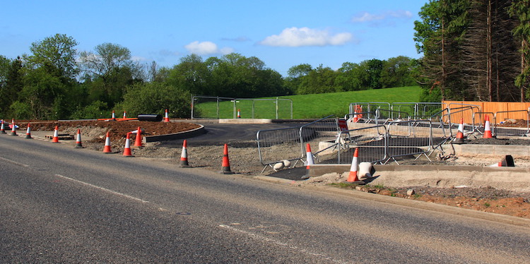
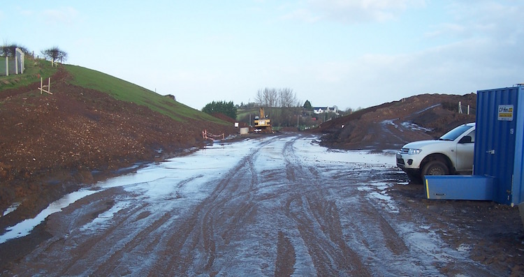
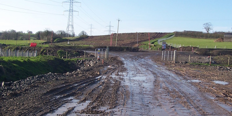
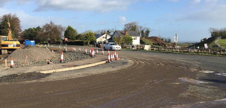
30 Aug 2016: The project is now in its
final stages, and the road is looking close to
completion in a number of locations. The
scheduled completion date is currently sometime
in October, and I haven't seen anything to
suggest any issues with this. Below I share a
few pictures that were taken at Ballyronan Road,
one of the three new roundabouts being built as
part of the scheme. These were taken at the
weekend by a contributor who prefers to remain
anonymous (thank you) and show the road in
advanced state at this location. Ballyronan Road
roundabout is completed and in use by traffic on
Ballyronan Road, but the bypass itself is still
unopen. The bypass at this spot looks to only
need its final wearing course of tarmac, lane
markings and signage to prepare it for opening.
[Transposed captions below fixed 31 Aug 2016,
apologies]
Pic 1: View south west across Ballyronan Road
roundabout on 27 Aug 2016, with the unopened
bypass both straight ahead and directly behind
the camera. Ballyronan Road, which runs
left-right here, is open as normal and the
roundabout seen here is in use. [Anonymous
contributor]
Pic 2: Walking forwards from the previous
location to the far side of the roundabout, this
is the view south west along the unopened
Magherafelt Bypass (towards Moneymore) on 27 Aug
2016. Note the street lighting on the left, and
the posts for road signs. [Anonymous
contributor]
Pic 3: This is the view north east along the
unopened Magherafelt Bypass (towards
Castledawson) from Ballyronan Road roundabout on
27 Aug 2016.The road ahead still needs its final
wearing course of tarmac and some signage, but
otherwise looks pretty completed. Again, note
the street lighting for the first few hundred
yards. [Anonymous contributor]
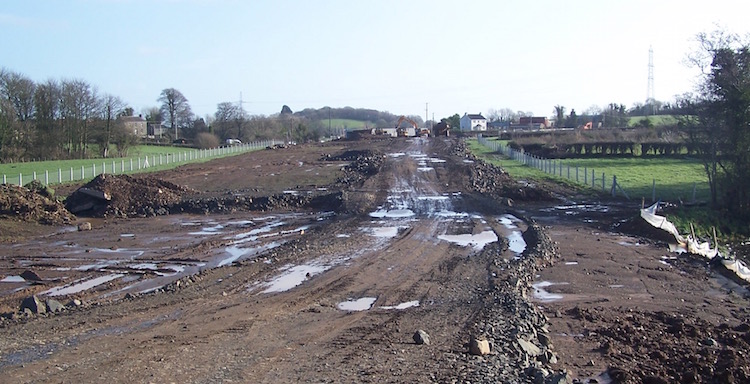
4 Jun 2016: A larger update tonight to
bring you a number of pictures that were taken
by Martin Young on 30 May (thank you!). These
were taken from public roads at three specific
locations - Castledawson Roundabout at the very
north end of the scheme, Ballyronan Road about
two thirds of the way along the scheme, and
Moneymore Road, at the very south end of the
scheme. The 19 month scheme now has only 5
months remaining, so we are entering the final
quarter where we should see things start to take
their final form over the coming weeks. Indeed
some areas, such as the very north end, are
looking very close to completion with tarmac
laid in several places. Completion is currently
scheduled for October 2016. The pics below are
arranged from north to south.
Pic 1: Looking due south from Castledawson
Roundabout on 30 May 2016, with the new bypass
really starting to look like a proper road with
kerbing and tarmac in place and the triangular
traffic island even taking shape on the left.
Just ahead is one of the three major cuttings on
the scheme, and the green colour shows that
nature has already begun reclaiming the banks,
perhaps assisted by some seeding. In the
distance is a farm accommodation overbridge,
shown in pic 2. The road will probably feature
an overtaking lane for vehicles heading south,
up this hill. [Martin Young]
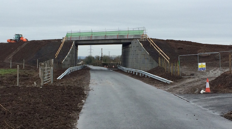
Pic 2: Zoomed in shot of the farm accommodation
overbridge that spans the middle of the cutting
shown in Pic 1, on 30 May 2016. The bridge has
its beams in place, and it looks as if it is
currently getting its deck and/or parapets
added. The drops at the left and right show that
the approach embankments to carry the laneway
are not yet in place. The white lines on either
side of the main road mark the location of the
drainage channels. [Martin Young]
Pic 3: Moving now to Ballyronan Road, about two
thirds of the way along the scheme, this is the
view north-east along the future bypass on 30
May 2016. It will meeat Ballyronan Road at a
roundabout, which is not yet completed but will
be sited where the photographer is standing.
[Martin Young]
Pic 4: Same location as pic 3, but turning 90°
to the right, this is the view along Ballyronan
Road out of Magherafelt on 30 May 2016. A
roundabout is to be built where the photographer
is standing and it looks as if some preparation
works are already underway. The bypass will run
to the left and right of the photographer.
[Martin Young]
Pic 5: Same location as pic 4 but turning
another 90° to the right, this is the view
south-west along the future bypass on 30 May
2016. Ahead is the second of the three major
cuttings on the scheme, which has now been
excavated. When I visited the site in February
work had yet to begin on this cutting, so that's
a lot of earth moved in four months. [Martin
Young]
Pic 6: Moving now to the southern end of the
scheme at Moneymore Road, this is the view east
along the future bypass on 30 May 2016. Ahead
the bypass approaches the photographer through
the third of the three major cuttings on the
scheme. It will terminate at a new roundabout
situated directly in front of the photographer.
The curved kerb in the foreground is part of the
central island. [Martin Young]
Pic 7: Moving about 100 metres to the left of
the previous shot, ie towards Magherafelt, and
turning round, this is a view of the future line
of Moneymore Road on 30 May 2016. Moneymore
Road, in the foreground, will be realigned along
this new route so that it meets the new
roundabout at the appropriate angle. The new
roundabout will be situated where the wire
fences are on the left. [Martin Young]
Pic 8: Same view as Pic 7, but walking about
100m back towards the future Moneymore Road
roundabout, this is half of the roundabout in
place on 30 May 2016 with all traffic currently
driving through the central island.
[Martin Young]
Pic 9: Finally, from the same location as Pic 8,
but turning about 45° to the left, this is the
other side of the future roundabout also in
place on 30 May 2016, and apparently actively
under construction. [Martin Young]
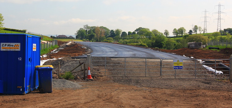
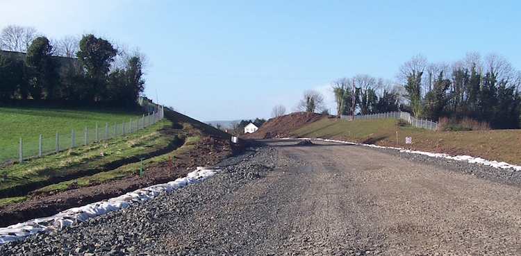
5 Apr 2016: Another small update to
bring you a shot of the Aughrim Road roundabout,
one of three new ground level roundabouts that
will be provided on the new bypass. The
roundabout has now been completed, although
traffic on Aughrim Road is just being diverted
around it for now since the bypass is not yet
open. The picture below was taken yesterday and
is the view looking east, ie away from
Magherafelt. This
is the same view before work began. The
photographer prefers to remain anonymous, but
thank you.
View east along Aughrim Road, near Magherafelt
towards the roundabout that the Magherafelt
Bypass will eventually use to cross from left to
right here. 4 April 2016. [Anonymous
contributor]
2 Apr 2016: A small update this time to
bring you a shot of the Loves Road bridge which
was completed a couple of weeks ago and is now
open to traffic below. This bridge will carry
the new Magherafelt Bypass over Loves Road. The
bypass is still being built so for now the
bridge has a temporary parapet to protect
workers. You can see how it looked two months
ago in pic 4 of the 10 Feb 2016 update when it
was still under construction. The location is
roughly here.
With thanks to Shay Sweetnam for sending me this
pic to share with everyone.
View east along Loves Road on 13 March 2016,
showing Loves Road now open and using the new
bridge that will eventually carry the A31
Magherafelt Bypass over it. The bridge abutments
are made from pre-cast concrete panels that are
held in place by strips which extend into the
fill behind them, using friction to remain in
place. The crash barrier is presuambly there to
stop an errant vehicle from damaging the panels
in a collision. [Shay Sweetnam]
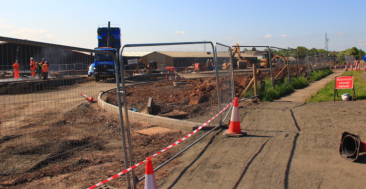
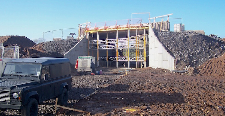
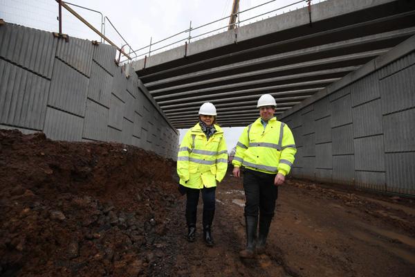
10 Feb 2016: Last Tuesday (2 Feb) I
enjoyed a tour of the A31 Magherafelt Bypass
courtesy of the contractor (BAM/McCann
consortium). A big thank you to Mark McCann of
FP McCann for facilitating the visit, and to
Derek Graham of the DRD for setting it up. I saw
a lot of fascinating engineering works up close
and took quite a few photos, 13 of which I share
below. They are arranged in order from north
(Castledawson end) to south (Moneymore end). It
is a rare treat to get photos of the scheme
taken on the site itself, rather than nearby
vantage points. All in all progress seems to be
on schedule with work progressing well on all
parts of the scheme. Congratulations to the
contractor for the work done to date. The scheme
is scheduled to be open to traffic around
October this year, so in time terms it is about
50% completed.
Pic 1: The view north along the
future Magherafelt Bypass from about half way
between the Castledawson Roundabout and
Killyneese Road on 2 Feb 2016. The picture is
taken from above what will be an accommodation
underpass which will give landowners access to
land on either side of the new road without
having direct access onto it. Ahead is one of
the largest cuttings on the scheme. Eventually
it will have an accommodation overbridge across
it running from left to right. Work on the
foundations for this appears to have started.
[Wesley Johnston]
Pic 2: View through the accommodation underpass
mentioned in picture 1 on 2 Feb 2016. This will
be used by a local farmer to access land on
either side of the road, while the new Bypass
will run left-right above it. The underpass
itself is made from pre-cast sections on the
left and right with a U-shaped section set on
top. The abutments are faced with pre-cast
concrete panels that are held in place by strips
which extend into the fill behind them, using
friction to remain in place. Some of these
strips can be seen on the right temporarily
hanging over the abutment. [Wesley Johnston]
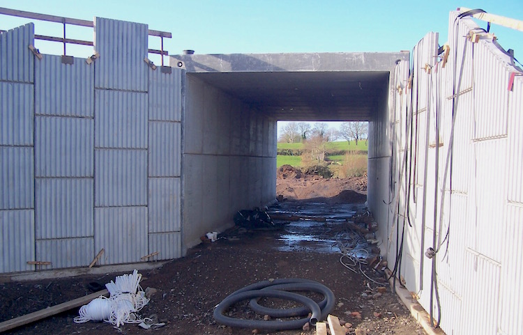
Pic 3: The view south-east along Killyneese Road
on 2 Feb 2016. This road was originally to have
been stopped-up completely by the construction
of the bypass, but after the Public Inquiry it
was decided that a limited-headroom underpass
could be provided. The underpass had just been
completed and was open to traffic when I
visited. It has been built in the same manner as
the one shown in picture 2 above. The
restriction to one lane is for three reasons (1)
to accommodate a footpath (2) because two lanes
would have meant a more expensive structure and
(3) to act as a traffic-calming measure as this
short stretch is now of a higher standard than
adjacent section of Kilyneese Road. Turning bays
have been provided at either side in case a HGV
ends up stuck here! [Wesley Johnston]
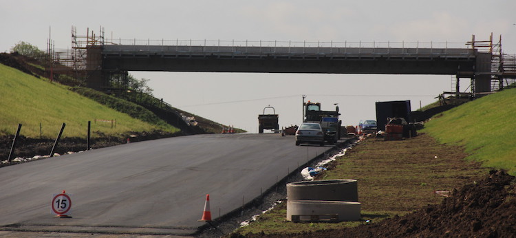
Pic 4: This is the view west along Loves Road on
2 Feb 2016, which will be a full-size bridge
constructed from concrete beams. Loves Road is
currently closed while the bridge is built. I
wasn’t able to get up close as high-pressure
water jets were being used to cut the concrete,
so we had to keep well back. Even from this
distance you could feel drops of water in the
air. The Bypass will run left-right across here
on an embankment. [Wesley Johnston]
Pic 5: The view south along the line of the
future Bypass towards Ballyronan Road on 2 Feb
2016. This will be the site of one of the two
intermediate roundabouts on the scheme. Work has
just begun to form the foundations for this
roundabout, but for now the existing road is
running as normal left-right. The short length
of hedge visible in the middle of the frame is
sited where the middle of the roundabout island
will be. Straight ahead the bare soil marks what
will be the second largest cutting on the scheme
- this hill has to be excavated right down to
the level of Ballyronan Road. In many cases the
material dug from cuttings is being re-used on
embankments elsewhere on the scheme, but more
fill is needed than can be found in this way. So
the contractor has entered arrangements with
other nearby landowners to obtain fill from land
that, for example, currently slopes steeply in a
way that is not conducive to farming. The
excavations will then leave land that will be
flatter and hence better for agriculture, in a
kind of win-win arrangement. [Wesley Johnston]
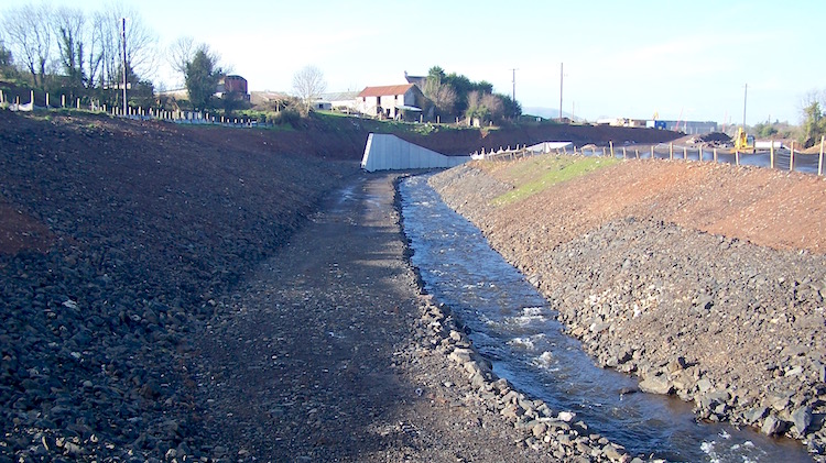
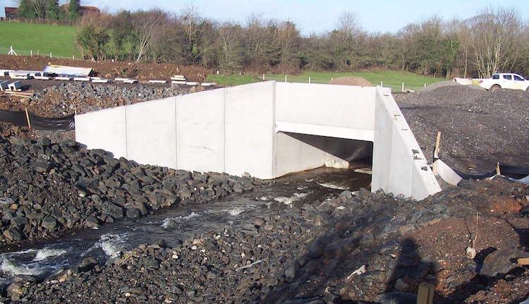
Pic 6: Near Killyfaddy Road a local river ran
along the line of the Bypass for a couple of
hundred metres and had to be shifted wholesale
to the south. This is the new watercourse
complete and in use on 2 Feb 2016. Great care
has gone into making it as natural as possible -
with boulders along the banks, as well as a
small, deep channel for normal flow (as shown
here) but with a wide, shallow channel for
dealing with floods in a way that mimics natural
watercourses. The banks here will be seeded but
otherwise nature will be left to take its
course. The new Bypass will run on the right
parallel to the river shown, with the river
crossing beneath it twice via bridges. [Wesley
Johnston]
Pic 7: Taken from the same location as the
previous shot, but turning 90° to the right,
this is the river flowing under the bridge that
will carry it under the future Bypass on 2 Feb
2016. [Wesley Johnston]
Pic 8: Taken from the same location as the
previous shot, but turning a further 90° to the
right, this is an accommodation underpass that
sits close to the river bridge. It will give
local landowners access to land on either side
of the new road, which will pass over it on an
embankment. Seen on 2 Feb 2016. [Wesley
Johnston]
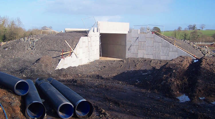
Pic 9: The view south along Killyfaddy Road on 2
Feb 2016 towards the large underpass that is
currently being constructed to take the road
beneath the future Bypass. This is about 300m
west of the river shown previously This
underpass is being built as a larger version of
the accommodation underpasses already shown,
namely with vertical sections on the left and
right and then a pre-cast U-shaped concrete
roof. Killyfaddy Road is obviously closed to
traffic while this is built. The Bypass will run
on a long (1km) embankment across this part of
the landscape. [Wesley Johnston]
Pic 10: A “mammal underpass” beneath the future
Bypass, seen on 2 Feb 2016. These are being
built at various points along embankments,
presumably in an effort to reduce the roadkill
toll of badgers, foxes etc. The person on the
left gives the scale - the truck above is (to
quote Father Ted) “far away” rather than
“small”! [Wesley Johnston]
Pic 11: This shot is taken about 800m from the
end of the scheme at the Moneymore Road end, 2
Feb 2016. This is the view east, away from
Moneymore Road, along the line of the future
Bypass as it runs on the long, 1km embankment
that is being formed here. Beneath the
photographer is a small watercourse passing
beneath another bridge. The number of structures
on the new road is quite striking, especially
since many of them will be invisible to road
users and yet still require a lot of work.
[Wesley Johnston]
Pic 12: Taken from about 300m from the end of
the scheme at the Moneymore Road end, this is
the view west on 2 Feb 2016 where the scheme has
a ‘last hurrah’ in the form of one more large
cutting, seen here in a very advanced stage with
the hardcore foundations of the road itself now
laid. At this location, the next material that
will go down will the tarmac itself. The white
plastic on the left and right marks drainage
channels that run down either side of the road.
The cutting squeezes neatly between existing
developments, including the house visible at the
upper left. [Wesley Johnston]
Pic 13: Finally, this is the view looking east
across Moneymore Road on 2 Feb 2016 towards the
line of the future Bypass. The cutting visible
on the right is the same one seen in picture 12,
but viewed from the other side. Workers have
just begun work on the new roundabout which will
eventually mark the terminus of the scheme here.
The road in the foreground is Coolshinney Road,
currently closed for the works. [Wesley
Johnston]
20 Dec 2015: We are eight months into
the project and there is now less than a year
left to estimated completion - the new DRD
Minister has paid
a visit to the scheme. The associated
press release gives the following useful summary
of work so far: "To date, around 75% of the
earth works have been completed which required
almost 500,000 tonnes of material to be moved.
The installation of the drainage culverts are
also almost completed and half of the
permanent fencing has been erected. The
construction of the farm underpasses and
overbridges along the route are also
progressing well." The comment about
overbridges "progressing well" is certainly
true, as demonstrated by the associated picture
showing the Minister beneath what looks like an
unidentified but impressively advanced
overbridge with beams in place (see below).
Finally, although I have been working on the
assumption that the scheme would be completed by
December 2016 (based on the 20 month estimate
given at project commencement in April), the
press release says that completion is now
expected in October 2016 - so no
pressure, BAM/McCann!
DRD Minister Michelle McIlveen
(left) with William Diver from the contractor
BAM/McCann, at an unidentified overbridge on the
A31 Magherafelt Bypass, 15 Dec 2015 [DRD image].
15 Nov 2015: This update is to bring you
the latest aerial video of the scheme taken on
29 October by Kilkeel firm Aquila.
It is embedded below (with thanks to Aquila for
the code) but in case that doesn't work the link
is given below the video.
We can see that a lot of
progress has been made during October. Starting
at the south end at Moneymore Road,
earthworks at 00:17 are not only completed but
road construction is underway with stone
foundations now in place on the first 600
metres. Aquila's notes explain that this is both
"site won" stone (meaning that it's come from
excavations elsewhere on the scheme) and
"imported" stone (which comes from further
afield, normally a quarry). The culvert that was
being built at 00:37 now appears to be
completed. Completed excavations continue to Killyfaddy
Road at 00:45 which will eventually cross
the bypass on a bridge. Work on the major works
required to divert a river are still well
underway at 00:50, including two culverts either
completed or nearly so, and a new river bed.
From here to Ballyronan Road at 01:08
earthworks are clearly underway at various
stages, and at least one more culvert. It's hard
to tell, but it looks as if some of the
foundations for the Ballyronan Road roundabout
may be in place. The next stretch is still at
the earthworks stage, and we come to Loves
Road at 01:34. Here the approach
embankments for the flyover that will carry the
bypass over Loves Road are very evident and it
looks as if preparatory works for the bridge
abutments are now underway. From here to Aughrim
Road, 01:57, not much has changed in the
past month, though the earthworks along here
seem completed. Foundations for Aughrim Road
roundabout now seem to be underway. After this,
the earthworks again appear very advanced with
foundations possibly going down. Work on the one
remaining major culvert at 02:13 has still not
commenced - it's not clear why this one has not
commenced yet. Perhaps there is some special
consideration here, for example ecological, that
limits when work can take place. The video
reaches Killyneese Road at 02:19, which
will pass under the new road via a
limited-headroom underpass. The approach
embankments here aren't yet completed, though
the presence of several earth-moving trucks here
suggets this is actively underway. Along the
final stretch earthworks appear very advanced,
and at 02:34 we can see that there will be an
accommodation overbridge (used to provide access
to private land severed by the road) over the
substantial cutting here. On the last 200 metres
before Castledawson Roundabout the
stone foundations of the road are in place, with
drainage structures evident on both sides. At
the end of the scheme, at 02:42, we can see that
work on the tie-in to the existing Castledawson
Roundabout is now underway, so people passing on
the A6 can now see the works at close hand. It's
possible that the contractor intends to open up
an access onto the roundabout to provide a route
in and out for works vehicles in the coming
months. At 03:00 we can see the huge field that
has been used to store spoil, which now looks to
be being taken away again. The remainder of the
video is a return flythrough along the scheme in
the opposite direction, but with less
annotation.
29 Oct 2015: Work has now been underway
on this scheme for 6 months, and with 14 months
still to go we are almost a third of the way
through the project. Another
aerial video has been released by Kilkeel
firm Aquila,
this one taken about a month ago on 29
September. So, bearing in mind that a month has
passed since this video was made, we can see
good progress on all parts of the scheme. The
video starts at the south end (Moneymore Road)
showing topsoil stripping now complete and
earthworks underway. You can see a culvert
taking shape at 00:32 before the video reaches Killyfaddy
Road at 00:44. The bypass will cross this
road on a bridge with no local access, though
work doesn't appear to have started yet on the
bridge itself. After this you can see two
substantial culverts taking shape at 00:45 and
00:58, which are both for a local stream that
has to be diverted as it currently runs along
the route of the road. From here to Ballyronan
Road the work seems limited to topsoil
stripping, and not much more has happened at the
site of the future roundabout at Ballyronan Road
at 01:13. From there to Loves Road, at
01:37, some earthworks have taken place and some
culverts are under construction. The new road
will cross Loves Road on a bridge, though again
this does not appear to have commenced as yet.
From here to Aughrim Road roundabout, at
01:47, we can see a completed embankment and
cutting in quick succession. After this is
another embankment, leading to the missing
bridge/culvert at 02:04, on which no work has
begun for an unknown reason, and continuing to Killyneese
Road at 02:16, which will pass under the
new road via a limited-headroom underpass.
Continuing north, the earthworks along here are
very advanced, including what looks like a major
embankment being built over a culvert at 02:34.
At 02:51 the video focuses on the field that
seems to have been used to store spoil for the
past few months - it looks as if material is now
being removed from here again, probably to
construct earthworks at various locations on the
scheme. At 03:00 we see a major cutting that
looks to be fully or nearly fully excavated,
before the scheme finally terminates at
Castledawson roundabout. Thus far the focus has
been on earthworks (embankments and cuttings)
and on culverting watercourses. In the coming
months I would expect to see the scheme
advancing with work commencing on bridge
structures and on drainage infrastructure along
the road itself. The coming winter will see
inclement weather and shorter periods of
daylight, so the contractor will be keen to get
as much as possible done before the worst of the
winter hits.
4 Sep 2015: Another
aerial video has been released, this one
taken on 27 August by Kilkeel firm Aquila.
It is computer-generated but composed of actual
aerial photography taken from a drone. The
comments below the video say that so far 150,000
tonnes of material have been excavated since
work began in April. The video starts about
1.5km from the southern end of the scheme and
goes all the way north to Castledawson
roundabout. It shows that at the south end of
the scheme works are at the stage of stripping
topsoil. The video reaches Ballyronan Road
at 0:30, and shows that gravel has been added
here to form the foundations of the future
roundabout here. North of Ballyronan Road a long
cutting seems to be complete, and the gravel
road base is being laid. At 0:51 you can see a
culvert under construction, and you can just
about make out the thin blue pipes that are
presumably carrying the water from the
watercouse that it will eventually carry. At
1:09 the video passes Loves Road, which
the bypass will cross via a bridge. More gravel
is evident here, and just to the north another
culvert is seen under construction at 01:12. In
this vicinity the works seem to be largely at
the topsoil removal stage. Further north,
beginning at 1:20 we come to the most advanced
part of the scheme, where there is a long series
of cuttings and embankments with gravel
foundations apparently in place for almost 1km.
At 01:32 we cross the site of the future Aughrim
Road roundabout, which also has some of
its gravel foundations in place. At 02:00 we see
a temporary bridge over a river, presumably to
allow construction vehicles to cross over. At
02:10 the video reaches Killyneese Road
which the new road will cross via a
limited-headroom bridge. This also seems to be
the location where many of the site vehicles are
being stored. From here to the Castledawson
Roundabout is another series of completed
cuttings and embankments, and more evidence of
gravel foundations. At 02:33 we see an enormous
area of bare soil which looks to be part of the
cutting. It's hard to tell from the video, but
it may also be functioning as a temporary
storage area for material excavated from
elsewhere. We reach Castledawson roundabout
at 02:42 where topsoil stripping has taken
place, but to date no attempt has been made to
modify the roundabout itself. With thanks to
Seamus Graffin for letting me know about this
video.
13 Aug 2015: Work has now been underway
on this project for four months, so in time
terms it's about 20% completed. So far I have
not been able to get any pictures of the works
underway. However, we are more than compensated
by the appearance last week of a YouTube video
taken by a drone showing the bulk of the site
from the air! The video is embedded below, but
in case this doesn't work here
is the link. The video tells us that
initital topsoil stripping has taken place along
at least half of the route, but that serious
earthworks seem to be focused at the north end
of the scheme between the Castledawsn Roundabout
and the future Aughrim Road roundabout. Along
this stretch, shown in the first part of the
video, a series of cuttings appear to have been
excavated, one of which is very substantial,
along with what looks like some embankments
(possibly using some of the same material). The
land around Magherafelt undulates with many
small hills, so the bypass is essentially a
continuous series of embankments and cuttings.
Although the site crosses several roads, these
are currently unaffected so the scale of the
work carried out during the summer is not much
is evident. For those interested, this is a
link to another computer-generated video
taken in June 2015 and which shows the works as
they were then, overlaid with the line of the
new road in white. I also saw this
tweet about a temporary bridge. I do not
know where this might be, but it could be the
bridge over a small watercourse evident at 2:17
in the video. If so, the bridge would be to
allow construction vehicles to access parts of
the site bounded by watercourses ahead of bridge
construction. Congratulations to the contractor,
as well as the folks who stuck these videos up!
3 May 2015: According to the DRD, work
began on the scheme properly on 18 April,
although the official ceremony occurred three
weeks beforehand (see previous update). With the
scheme due to last 20 months, a starting date of
18 April would see the scheme completed in late
December 2016. As I said before, I will bring
you what news I can over the next two years - if
anyone takes photos of the scheme as it
progresses, I'd love to hear from you.
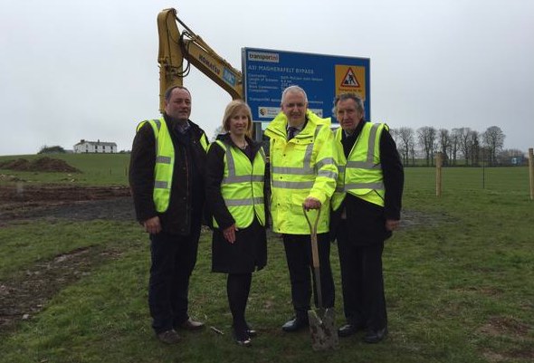
25 Mar 2015: All systems are go for
construction of the Magherafelt Bypass! Although
some preliminary site works have been underway
for a few weeks, yesterday saw the official
"cutting of the first sod" ceremony by the DRD
Minister Danny Kennedy. The DRD
press release confirms that the scheme
will last 20 months, so we could expect
completion around November 2016. The scheme is
estimated to trigger a reduction of traffic in
the town centre in the order of 30%, and that
the bypass will attract 14,000 vehicles per day.
The press release also says that once the bypass
has been opened and after things have been
allowed to settle they will then look at traffic
arrangements in the town to see if any
opportunities exist to improve the use of road
space. The cost of the scheme is given as £35m,
but this may be only the construction cost,
rather than the total project cost which would
include things like design costs and land
acquisition. As the road is entirely off-line
(except for the locations where it crosses other
roads and at its two termini) there should be
little disruption to road users - indeed, it
will be quite hard to view progress on this
scheme as so much of it passes through open
countryside away from public vantage points.
However I will bring you what news I can over
the next two years - if anyone takes photos of
the scheme as it progresses, I'd love to hear
from you. The people of Mid Ulster will be
delighted that this scheme is now underway after
38 years in planning.
28 Feb 2015: The contract for
construction of the Magherafelt Bypass was
awarded to the BAM/McCann consortium on 18
February 2015. Congratulations to them. This is
the same contractor who is also about to begin
work on the dualling
of the A26 from Glarryford to Drones Road,
so these two schemes will be proceeding
simultaneously and by the same contractor. they
are not hugely far apart, so they may even be
able to share some resources between the two
sites. According to the DRD
press release work is due to begin "before
the end of the financial year", ie 1 April, so
we could expect work to get underway within the
next four weeks. Disruption to road users should
be minimal as the scheme is entirely off-line
except for the locations where it crosses other
roads and at its two termini. The cost given in
the press release is £35m; however this may be
just the construction cost rather than the
overall project cost which would also include
things like design work and land acquisition.
The scheme is due to last 20 months, so assuming
a start on or around 1 April, this would see the
road completed shortly before Christmas 2016. As
work is going to start very soon I have moved
this scheme to "under construction".
28 Jan 2015: With the contractor due to
be appointed within the next couple of weeks,
what appears to be an advanced site-clearance
contract has commenced on site. According to the
image in this
news report in the Mid Ulster Mail, it
involves topsoil clearance and probably also
archaeological investigations. The report cites
a DRD source as confirming that the contractor
is due to be appointed in "early February". The
winning contractor will likely want to begin
work as soon as possible after this.
18 Dec 2014: According to a question
answered in the Assembly by the DRD Minister last
week, things seem to be progressing
smoothly towards commencement of this scheme. He
confirmed that tenders closed on 24 November (as
per the previous update below) and that the
contractor should be appointed soon. Assuming no
disputes, work should get underway in February
with completion due in October 2016, ie a total
construction period of 20 months. He also said
that service diversions are underway (ie moving
water pipes, electrical & telephone cables
etc) and that "the archaeological investigation
and vegetation clearance will begin shortly". We
know that some archaeological trial pits were
dug around the summertime, so this is presumably
further work. Vegetation clearance work is a
necessary first step, and the winter is a good
time to do it as it avoids the complications of
the bird nesting season.
31 Oct 2014: The tender process has been
underway now since April, and the deadline for
submission for tenders is 24 November 2014. The
DRD Minister answered
a question about progress on this scheme
in the Assembly on 31 October. He noted that
archaeological surveys including some trial pits
have been carried out, temporary fencing around
the vested land (land bought by the DRD to build
the scheme) has been erected. He anticipates
that work will begin "early next year", which is
no different than was the case a few months ago,
so that is reassuring.
4 Apr 2014: The "tender" for this
project has now appeared on the DRD's
web site. Since the last update it has
been clarified that this first phase of the
process is to create a shortlist of construction
firms that will be invited to submit tenders in
the second phase. The two phases will happen
'behind the scenes' so the next thing we're
likely to hear is the tender being awarded,
around December 2014 or January 2015. The
two-phase approach is a way of weeding out
companies that have little or no chance of
winning the tender before they put in proper
tenders and thus saves both the DRD and
contractors time. The value of the construction
tender is given as £25m (as opposed to the
overall project cost, which also includes things
like planning and land purchase, and is
currently estimated to be about £35m-45m). The minutes
of a Transport NI [the body that oversees Roads
Service] board meeting on 26 February suggest
that a review was recently carried out to make
sure that this scheme's "appropriate assessment
screening" was adequate. This is a long-winded
way of saying that they re-checked planning work
that was done on this project's environmental
impact to make sure that this project cannot be
challenged in court in the same way as the A5
project was last year. This may account for the
longer-than-expected delay between funding being
announced for this project in July 2013 and the
tender being released last week.
25 Mar 2014: According to a DRD
press release, the tender for construction
of the A31 Magherafelt Bypass has been released,
although at the time of writing this update this
was not reflected on the DRD's own
web site. The Vesting Order has also come
into effect - this is the legal document that
allows DRD to purchase the required land. The
tender process is expected to take 8 or 9
months, so we should expect to see construction
get underway in either December 2014 or January
2015. The press release estimates that work will
last about 20 months, so the road should be
completed around August or September 2016.
1 Mar 2014: I have had a useful chat
with a DRD representative about this scheme and
they have confirmed that the
construction tender is very likely to be
released this month, as planned, which would see
the contract awarded in either December 2014 or
January 2015, with construction likely to begin
almost immediately. There should be relatively
little disruption during the works as most of
the engineering works are taking place offline.
The only impacts on the existing road network
will be places where the new bypass joins or
crosses over an existing road.
30 Jan 2014: More bad news for
supporters of this scheme. The release
of the tender for construction has been
delayed again - this time, until March 2014. It
originally had an estimated release date of
October 2013 which got pushed back to January
(see previous update) and now March. That means
that it will have taken at least 8 months to go
from funding allocation to tender release, which
is unusually long. It suggests that there may be
some kind of issue behind the scenes that is
holding everything up.
11 Dec 2013: There seems to have been a
bit of a delay getting this scheme out to
tender. Although in August the estimated tender
release date was October 2013, this was pushed
back to November, then December and is now estimated
to be released in January 2014. It's not
clear why this is. However, since the whole
tendering process ("procurement") normally takes
about 9 months, it shouldn't too badly affect
the estimated start date of September 2014 which
was announced in July, as this is still 8 months
after January.
21 Aug 2013: With this scheme now having
been approved, it has now appeared as
an advance notice on Roads Service's
"future contracts" list, with an estimated
release date of October 2013. This is bang on
schedule if construction is to get underway
around September 2014 as announced in July.
These are exciting times for Magherafelt.
1 July 2013: Today the Finance Minister
announced in
Stormont the allocations of funding for
the 2014/15 financial year, ie the period
starting in April next year. He said "[Regional
Development Minister Danny Kennedy] set
out a number of road schemes that, he
suggested, could be advanced in the next
financial year to make use of any additional
capital funding [freed up by the delay in the
A5 scheme due to legal action]. Given that all
significant capital projects have a
considerable lead-in time, the Executive
agreed that it would be helpful to consider,
as early as possible and in a strategic
manner, projects that may be advanced in
2014-15. Pending further consideration
of all options and to ensure that valuable
time is not lost, the Executive have agreed
that the Regional Development Minister can
proceed with the Magherafelt bypass
project". While it's slightly surprising
that the Magherafelt Bypass managed to squeeze
in ahead of the A6 dualling scheme (Randalstown
to Castledawson), the Magherafelt Bypass is
badly needed and this will be very welcome. In
his own
press release, the DRD Minister suggests
that work could begin in 14 months' time, in
September 2014, which is in keeping with the
length of time that the procurement process
would take. (Note that this press release
erroneously states that the Bypass is 3km long,
when it is in fact almost 6km in length.) There
are still some minor processes to complete,
namely "the business case and some environmental
work", but we could expect a procurement process
to be underway before the end of 2013 which will
hopefully see a contractor appointed ready for
work to begin next autumn. Great news for Mid
Ulster and anyone who tries to negotiate the A31
through Magherafelt.
27 May 2013: It's been two-and-a-half
years since the last update on this scheme, but
it was the subject
of an oral question to the "Roads"
Minister in Stormont last week. As I predicted over
on my blog back in April, this scheme does
indeed seem to be one of those that *may*
benefit from the delay in the A5 scheme. The
minister said "The situation is such that we
now have to look at other potential schemes
that can be brought forward. I have indicated
that I am doing that in conjunction with
Executive colleagues, principally the Finance
Minister, and we will continue to do that. The
schemes that are most procurement-ready
include the A26 Glarryford scheme,... the A6
[Randalstown to Castledawson] scheme, the
Magherafelt bypass and the A55 [Outer
Ring widening at Knock] scheme in Belfast."
What he is saying is that all of these schemes
have the possibility of going ahead sooner
rather than later, depending on what the
Executive agrees. Specifically on the
Magherafelt Bypass, he gave a best-case
timescale: "The notice of intention to
proceed and the direction order for the A31
Magherafelt bypass were published in September
2010. It is estimated that it may be
possible to commence construction in the last
quarter of 2014-15 [ie Spring 2015] if
an early decision of funding is made."
There is, of course, no guarantee that this
scheme will actually get the go-ahead, but at
least it's in with a fighting chance.
19 Sep 2010: Roads Service
have finally published the Report of the
Inspector of the Public Inquiry, which was held
almost a year and a half ago. You can download
and read the entire Report here.
The Inspector heard a large number of comments,
but only recommended one change. He recommended
that instead of stopping up Killyneese Road,
there should be a limited-headroom underpass to
permit movements of pedestrians, livestock and
cars. Roads Service have accepted this
recommendation and announced
on 13 September that they are proceeding to the
next stage, which is to draw up all the
"statutory orders". This just means that they
will produce the necessary legal documents such
as the Direction Order (giving permission to
build a new trunk road) and the Vesting Order
(giving Roads Service the right to buy the land
needed). There is still no firm timetable for
construction, which is currently given as "2013
to 2018". The cost is still being quoted as
"£36m".
14 Dec 2009: The public
inquiry was held in April and early May 2009.
The Inspector's report is now in the hands of
Roads Service, who (according to this
press release from last week) are not
planning to publish the report until April/May
2010 when they release their reponse and
Departmental Decision (ie what they plan to do
next). Construction is still on the long finger,
currently estimated to be between 2013 and 2018.
1 Mar 2009: The scheme
proposals have now gone to a Public
Inquiry. The inquiry will be held in the
offices of Magherafelt Borough Council and will
begin on 29 April 2009. The Departmental
Statement into the scheme has
been published, detailing the proposal for
the inquiry. These show that the cost estimate
is now £36, up from the £33m quoted last May.
Also, Roads Service issued
a leaflet on the scheme in November 2008.
It doesn't say anything new, but provides a
useful summary of the scheme.
16 May 2008: Roads Service
has published two statutory notices: the Notice
of Intention to Make a Direction Order (needed
to legally create a new trunk road) and Notice
of Intention to Make a Vesting Order (needed to
acquire the required land). This
press release from May 2008 suggests that
the cost has jumped almost 300% from £13m to
£33m. This is a huge jump, but is likely due to
the fact that the chosen route is much longer
and over much more challenging terrain than
previously estimated. In addition, the "Investment
Delivery Plan For Roads" published in
April 2008 has made it clear that the scheme
will not begin until at least 2013, due to money
shortages, and could be even later than this.
3 Mar 2008: A leaflet was
released by Roads Service in February which gave
further details of what is proposed. The project
will consist of a high-quality
single-carriageway road with 1m wide hard
strips. Other than the four roundabouts (see map
above) there will be no other accesses, with
minor roads either closed, diverted or bridged.
The proposed route now differs from that first
proposed in 2005 since it now follows an offline
route all the way to the Castledawson
roundabout, instead of simply joining the A31 at
the northern edge of the town. There is also an
indication that some sections of the road will
feature a 2+1 overtaking lane arrangement.
Subject to a smooth run through statutory
processes, work may begin in 2011 with
completion two years later
17 Nov 2007: According to a
news article in the Mid Ulster Mail on 18 Oct
2007, the consultants who were appointed in 2006
have now added two further route options in
addition to the one included in the original
consultation document "within a large study area
to the East and the North of the town". The
final route may be one of these, or a
combination of them. A further consulation will
apparently take place once the Preferred Route
has been decided.