Status |
Construction scheme (completed) |
Where |
To grade separate the A26/M2 junction (j10) at the south side of Ballymena by utilising the redundant bridges at this location. |
Total Length |
2.1km (1.3 miles) dual carriageway and 0.9km (0.5 miles) of other roads |
Dates |
M2 junctions 10 to 12 opened 26 Apr 1969
Scheme proposed 28 Feb 2005
Preferred route announced 27 Oct 2005
Public inquiry held March 2007
Notice of "intention to proceed" published March 2008
Advanced site clearance began mid Feb 2009
Construction began around 4 June 2009
Southbound carriageway opened 15 Aug 2010
Northbound carriageway opened 24 Aug 2010
(around 4 months later than original completion date of "Apr 2010" as of June 2009, later changed to "July 2010" as of Apr 2010)
Scheme officially opened 28 Oct 2010 |
Cost |
£12.1m as of Mar 2009
(revised from £7m as of 2006) |
Photos |
See below |
See Also |
Detailed design of scheme [PDF format, 1.4MB]
Roads Service Brochure (Mar 2005, 500kB PDF)
Official web site on scheme including photo updates
General area map |
This most interesting scheme is required because of changing road building policy, and is difficult to understand without looking at the general area map linked to above. When the M2 motorway was being built in the 1960s and early 1970s the sections bypassing Antrim (j5-7) and the section bypassing Ballymena (j10-12) were built early on. The plan was then to fill in the gap with the remaining section of motorway.
In the mean time, the Ballee Road East was built to temporarily connect the current A26 to the M2 at junction 10. Junction 10 was constructed as a roundabout with two overbridges ready to take the completed M2. However, the motorway plan was axed in 1975, meaning that the route under the bridges have never been used, and the Ballee Road East the main road for the past 30 years. It is currently a dual-carriageway which was built in 1969 at the same time as the Ballymena Bypass.
Now that the M2 plans have been shelved once and for all, Roads Service has decided to re-route the Ballee Road East down under these redundant bridges so that it flows directly onto the M2. This change will substantially reduce congestion and is so obvious that it is amazing that it wasn't done long before now! The M2 at Ballymena today carried 25,500 vehicles per day in 2005, and the Ballee Road East 22,500. 15,000 of these vehicles would pass straight through if the underpass was built, substantially easing flow at the junction.
According to Roads Service, the scheme will involve the construction of just under a mile of dual-carriageway and the provision of two 300 metre sliproads. The existing Ballee Road East will be cut in two, with the eastern portion still joining the roundabout at junction 10 and serving the industrial estate. The Liminary Road will be diverted to join the new roundabout on the eastern side. At least two properties will require demolition. On the new section of dual-carriageway there will be one central-reservation crossing to allow vehicles to do a U-turn to access the existing properties at the south western edge of the road. This can be seen on the map linked above. Note from the computer generated images below that the new road appears to have a "wide central median", something previously only seen in the Irish Republic and which makes future upgrades much easier.
The cost of £6.1m publicised in 2005 had risen to £7m by the time this public consultation was released in July 2006, and had risen again to £12m by March 2009.
Progress
28 Oct 2010: The scheme was officially opened today by the Mayor of Ballymena, Maurice Mills. The "Roads" Minister Conor Murphy confirmed the nature of the benefits of the scheme and provided updated traffic figures: "This stretch of road is an essential element of the development in the area providing a direct connection between the M2 and the A26 dual carriageway, taking traffic off the Larne Road Roundabout and thus giving the traffic a continuous straight through route. The M2 Ballymena Bypass currently carries over 23,000 vehicles per day and the A26 Ballee Road East over 22,000 vehicles per day." Work over the past two months has been on ancillary works associated with the main scheme which opened to traffic in late August. Due to the sizeable nature of these works I am therefore marking this scheme as being completed today, rather than back in August when the new dual-carriageway was opened.
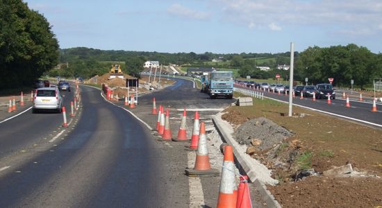
19 Sep 2010: The main part of the new A26/M2 link is now largely completed. Outstanding works here are limited to tidying up and landscaping, and some signage (the odd sign placed in the hard shoulder has vanished!). Work on the "old" truncated section of A26 is less advanced. The location where the original road diverged from the line of the new road is now completely tied in (pic 1) but the works to reduce the capacity of this old section of road are less advanced. At the south end, work seems to be underway to place a metre or so of soil on top of the old road. This appears to involve actually burying the old road under the soil without removing it (pic 2), which is unusual as the usual practice when landscaping is to remove the old road surface first. We shall have to wait and see whether this is what is happening here. Hopefully these works will be completed soon so that we can add this scheme to the list of completed projects.
The route of the old road to the left is now visible only as the line of the footpath. Compare this to the picture in the previous update. 16 Sep 2010. [Noel O'Rawe]
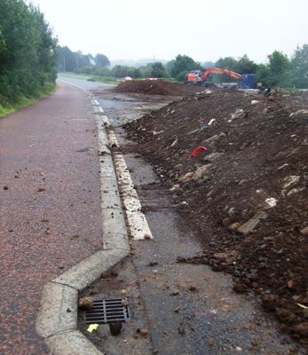
The works on the old section of the A26 appear - at first glance - to involve simply burying the old road under a metre of soil. 16 Sep 2010. [Noel O'Rawe]
11 Sep 2010: The two photos below were taken about two weeks ago and show two of the most recent changes on the road.
The realigned Ballee Road East (old on the left) on 22 Aug 2010. [Noel O'Rawe]
The southbound offslip to the Ballee Road roundabout has now been realigned to join the roundabout at a more acute angle, as seen here on 22 Aug 2010. [Noel O'Rawe]
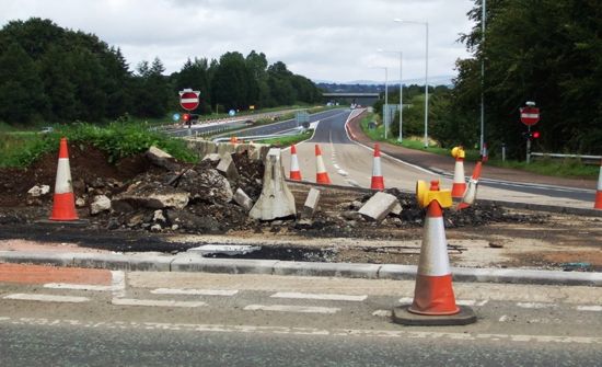
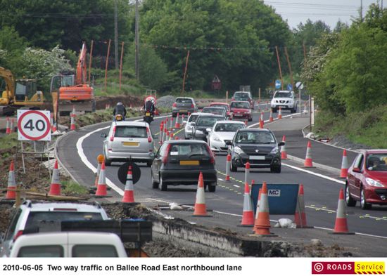
25 Aug 2010: The northbound carriageway of the new road was opened to traffic (with lane restrictions) shortly after 9pm last night. Traffic is now using the new underpass in both directions, taking approximately 70% of traffic off the Larne Road roundabout. This has already made the roundabout much quieter. The eastern end of Ballee Road East is now permanently severed from the main A26. Some work still remains to tidy up the point where the road has been realigned. One thing that has raised eyebrows is the appearance of a new sign at the southbound offslip to the Larne Road roundabout (see below) which has been placed in the hard shoulder. This is probably due to lack of space for such a large sign on the grass between the motorway and the sliproad. While not "wrong" as such, it is very unusual because the unprotected metal pillars present a collision risk to vehicles pulling onto the hard shoulder. See this early example of the same issue arising on the English M1 motorway. In addition, the decision to sign this as "A26" rather than "A26/A36" or just "A36" is surprising. It is true that motorists going into Ballymena here will take the A26 to go into the town. However, the principal part of the A26 lies straight ahead, not up this sliproad, which is a possible source of confusion. The other main inter-urban A-class road that meets this roundabout is actually the A36 to Larne (although this is signed on the direction sign further back on the M2).
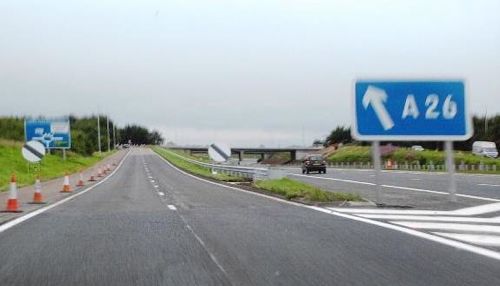
The new "gore" sign at the M2 offslip to Larne Road roundabout which has been placed very unusually in the hard shoulder. Seen on 19 Aug 2010. [A42_Sparks]
18 Aug 2010: Some pictures in this update thanks to Noel O'Rawe who photographed the road on the day of opening. Roads Service have said that when the scheme is completed the truncated part of Ballee Road East, which will then only serve the Pennybridge Industrial Estate, will be de-dualled, ie reduced to a normal two-lane road by removing one side of the dual-carriageway. The scheme has had the side effect of increasing the length of the M2 motorway by 800 metres. Roads Service have also put some new images on their web site (scroll down to "August") including some fantastic action shots of plant machinery, if that's your thing! In other news, the new signage at the Larne Road roundabout has revealed that the A36 Larne Road Link (into Ballymena) has now been renumbered to A26.
View east along Ballee Road East with the new road straight ahead and the old road to the left. Northbound traffic is still on the old road, while southbound traffic has shifted onto the new. Seen on 15 Aug 2010. [Noel O'Rawe]
View south from the south bridge with the southbound lanes open on 15 Aug 2010. [Noel O'Rawe]
View north from the south bridge on 15 Aug 2010, showing traffic passing beneath the Larne Road roundabout for the first time in 32 years. [Noel O'Rawe]
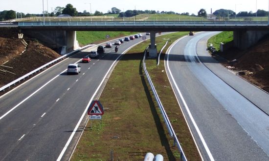
View south from the north bridge on 15 Aug 2010. [Noel O'Rawe]
View north from the north bridge on 15 Aug 2010, showing the unfinished tie-in to the southbound M2 ahead. Tarmac is being laid on the northbound lanes. [Noel O'Rawe]
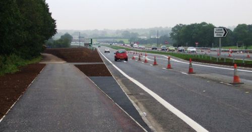
15 Aug 2010: The southbound carriageway of the new road and the two sliproads on this side were opened today. Work is still underway to tie the northbound carriageway into the Ballee Road East at the south end of the scheme, which is presumably why the southbound carriageway has opened first. Roads Service is now indicating that the whole scheme should be open by the end of August. The picture below was taken yesterday, about 24 hours before the southbound carriageway opened.
View north east along the new road with the Larne Road roundabout bridges ahead. The southbound carriageway (the nearer of the two) and the southbound onslip (closest strip of tarmac) both opened on 15 Aug 2010. Picture taken on 14 Aug 2010. [A42_Sparks]
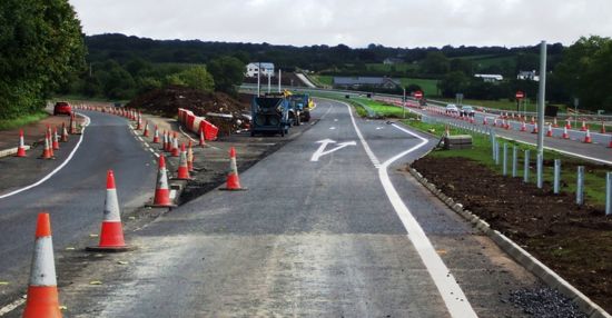
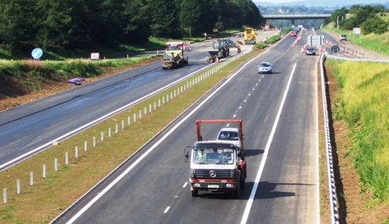
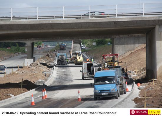
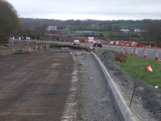
25 July 2010: Work has now advanced to the point where laying the final road surface, signage and lining is the main outstanding job. Work to tie the existing Ballee Road East to the new dual-carriageway is well advanced, as is work to tie the other end into the M2 Ballymena Bypass. Work in the middle section beneath the bridge is the most advanced. It's starting to look unlikely that it will be completed by the end of July as hoped, but certainly work is neverless near completion. Roads Service have put several new images on their web site.
View north from under the Larne Road roundabout on 10 July 2010. [Noel O'Rawe]
View south from the roundabout, along the future southbound onslip on 10 July 2010. [Noel O'Rawe]
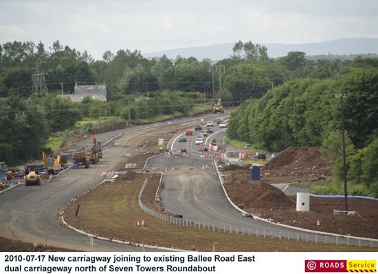
Work underway to tie the existing Ballee Road East (in distance, where cars are) to the new road (foreground) well advanced on 17 July 2010. [Roads Service]
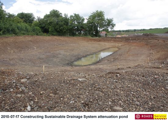
One of the attenuation ponds, which will collect water from the drains in the road during heavy rain to prevent it overwhelming local streams and let contaminants settle out. [Roads Service]
11 Jul 2010: The project is progressing very well, with work to tie in the new road to the existing Ballee Road East well underway. The scheme is still scheduled to open at the end of July, but the exact date is not yet known. The images below were taken about a month ago, but show how far advanced work was even then.
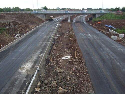
The view south from the north bridge on 13 Jun 2010 [Noel O'Rawe].
Looking north towards the junction from near Liminary Road on 13 Jun 2010. [Noel O'Rawe]
21 Jun 2010: As the scheme nears completion (due within 6 weeks by current estimates) the kerbing and sub-surface is being installed on the new dual-carriageway beneath the Larne Road Roundabout. The superelevation (the angle of the road surface) of the new road as it turns sharply west is now very obvious - this is necessary to safely permit traffic to travel at high speed on the finished road. On the Ballee Road East the existing dual-carriageway is being realigned onto its new route under the bridges. Roads Service have put up some new pictures on their site, two of which I include below.
Ballee Road East undergoing realignment on 5 Jun 2010. [Roads Service]
The sub-surface of the new road in place on 12 Jun 2010. [Roads Service]
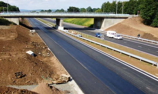
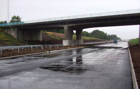
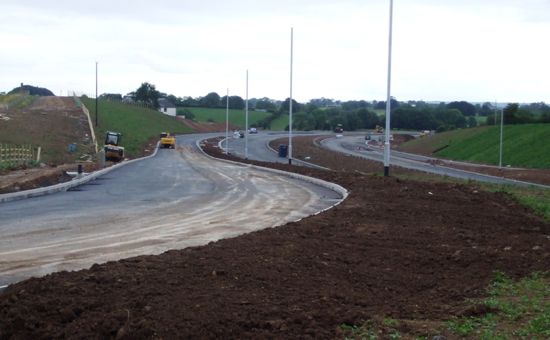
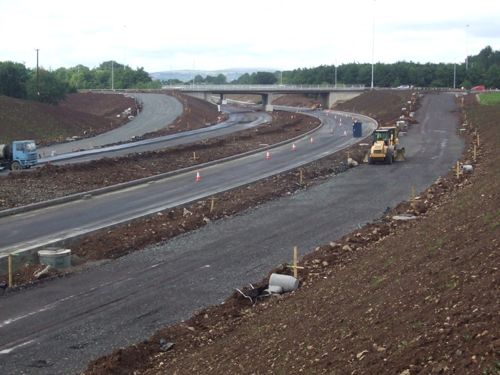
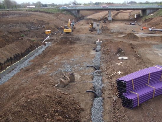
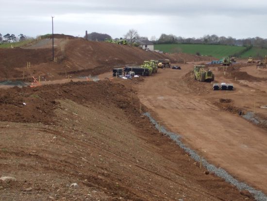
6 May 2010: Work has progressed very well in the past month. The earthworks for the new road, including beneath the bridges, are now complete, with drainage channels in place and the line of the central reservation visible (pics 1-3). Work has now begun on the eastbound A26 Ballee Road East which is now being realigned towards its future route beneath the bridges (pic 4). Work on updating the bridges themselves is almost done (pic 5). Completion is currently estimated as "Summer 2010". Roads Service have also put up some good photos from April on their web site.
Pic 1: View north towards the M2 from the north bridge on 25 Apr 2010
with drainage channels being installed. [Noel O'Rawe]
Pic 2: View south from the same bridge, showing work progressing on 25 Apr 2010. [Noel O'Rawe]
Pic 3: The view south from the south bridge on 25 Apr 2010.
On the left is the future southbound onslip. [Noel O'Rawe]
Pic 4: View east along the eastbound carriageway of the A26 Ballee Road East. The kerbs show that the road is being realigned to the right to go across the field ahead. 25 Apr 2010. [Noel O'Rawe]
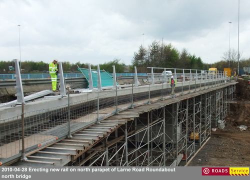
Pic 5: Work progressing on the parapet of the north bridge. [Roads Service image]
For updates before April 2010 please see the archive.
Photos

Computer generated impression of the approach to the new junction seen from the south. [Roads Service]

Computer generated impression of driving east on the new link road. [Roads Service]
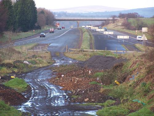
Looking north towards the M2 from the north of the two junction 10 bridges. The link road will go under the camera to directly join the M2 ahead. [Photo by Wesley Johnston]
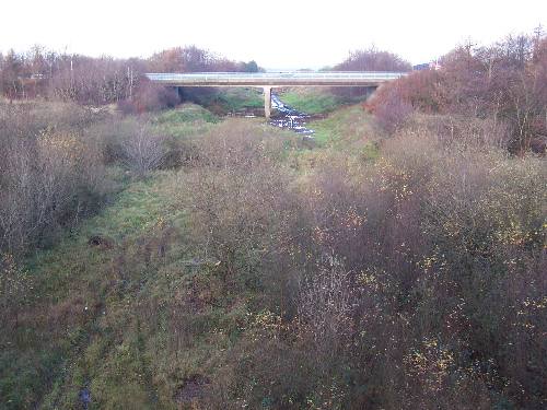
Looking north towards the M2 from the south of the two junction 10 bridges. The bridge ahead carries the other side of the roundabout. The new link road will run straight through here. [Photo by Wesley Johnston]
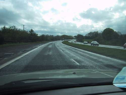
Travelling along the Ballee Road Link away from the M2. This road will ultimately flow directly onto the M2 rather than the roundabout. [Photo by Wesley Johnston] |
