| Route |
Forms a north-south bypass of Ballymena, taking what is otherwise the A26 round the east of the town |
| Joins |
This motorway joins to no other motorways or HQDCs
|
| Length |
7.7 km / 4.8 miles
|
| Width |
2+2 lanes |
| Opened |
26 April 1969 |
| Cost |
£5.0m (£55.1m in 2005 prices) |
| See Also |
M2 and M22 motorway on this site
M2 on CBRD
Network map on this site
History of motorways on this site |
The Ballymena Bypass is essentially part of the A26 route that connects Coleraine south towards Belfast, bypassing Ballymoney and Ballymena on the way. It is the only part of the route that has motorway restrictions, and is hence the highest standard of road on the whole A26 route. The reason it carries the number "M2" is that it was originally supposed to be part of the M2 motorway. The original plan to use the M2 number for a motorway extending from Belfast to Coleraine has now been abandoned, but the number remains as an historical anomaly. The Ballymena Bypass is also the only motorway in Northern Ireland that has no connections of any kind to any other motorway.
Junction Map | Construction Timeline | Route Description | History
Traffic Data | Heritage Motorway? | The M2 Number | Photographs
Junction Strip Map
|
NORTH
Begins as A26 Crankill Road towards Coleraine
|
M2 j12.
TEESHAN, BALLYMENA |
.
A26 Crankill Road
(to Ballymena)
|
|
|
|
4.5 km / 2.8 miles - 2+2 lanes |
M2 j11.
BROUGHSANE ROAD, BALLYMENA |
A42 Broughshane Road
(to Ballymena)
|
|
A42 Raceview Road
(to Carnlough) |
|
3.2 km / 2.0 miles - 2+2 lanes |
M2 j10.
LARNE ROAD, BALLYMENA |
A26 Larne Road Link
(to Ballymena)
former Ballee Road East
|
|
Private access
A36 Moorfields Road
(to Larne)
Liminary Road |
|
Terminates as A26 Ballee Road East towards Antrim
SOUTH
|
Construction Timeline
| J10 - J12 (Larne Road to Teeshan) |
26 Apr 1969 |
| Grade separation of Larne Road roundabout (J10) |
Aug 2010 |
Route Description
The Ballymena Bypass begins as the A26 Ballee Road East dual-carriageway just south of the Larne Road roundabout to the south-east of Ballymena. The Larne Road roundabout itself was built with bridges in place to take a future extension of the M2 from Antrim. This plan was abandoned in the mid 1970s, but the bridges were eventually used in 2010 to connect the M2 directly to Ballee Road East. The M2 then goes almost due north and runs gently downhill and across the marshy Braid River Valley. Here it meets the A42 Broughshane Road, east of the town, which is a modified diamond, featuring two southbound onslips to prevent traffic on the A42 having to turn right across the carriageway. The eastbound->southbound onslip does a 180 degree turn around the remains of a Norman Motte! The motorway then curves north west and runs for about 3 miles through shallow cuttings and embankments towards the Teeshan Interchange about a mile north of the town. This is a a freeflow interchange with the A26, similar in design to the one on the M2 at Greencastle (j2).
History
The history of the original M2 project is on the M2/M22 page. The scheme was designed to connect Belfast and Coleraine via Glengormley, Antrim, Ballymena and Ballymoney. The split in the carriageways near what is now junction 7 at Antrim was to have allowed the M2 to sweep north and round Ballymena. Due to a slower pace of construction than on the earlier M1 project, it was decided to build the most-needed sections of the M2 first, and then fill in the gaps. So the M2 hill section from j2 to j4 (Greencastle to Glengormley) opened first in 1966, followed by the Ballymena Bypass (from j10 to j12) in 1969 and the Antrim Bypass (from j5 to Randalstown) opening in early 1973. The gap sections were then opening, with the Foreshore (j1A to j2) opening in mid 1973 and the Glengormley to Antrim section (j4 to j5) in 1975. At this point, the direct rule ministers who had taken over after the dissolution of Stormont cancelled the M2 project leaving the M2 Ballymena Bypass unconnected to the rest of the M2. Over time, the A26 has been dualled on both sides of the Ballymena Bypass and the Roads Service has now effectively abandoned any plans to complete it. It therefore stands alone. It is generally believed amongst interested parties that junction 8 was to have been a junction for Kells and Connor, and junction 9 was reserved for a possible southern bypass of Ballymena. The empty bridges at Larne Road roundabout (j10) were eventually used in 2010 when the Ballymena Bypass was connected directly to the A26 Ballee Road East.
Traffic Data
| Location |
Vehicles / Day |
Year and Source of Data |
| J10-J12 |
25500 |
2006. Roads Service - see here |
Heritage Motorway?
The M2 Ballymena Bypass is a strong contentor to be called a "heritage motorway". As of 2010 it still features many of the original features of 1960s motorway construction, including the original peat central reservation, and kerbstones between the carriageway and the hard shoulder. Driving this road gives the motorist a rare glimpse into what it was like to drive the early motorways in the 1960s.
The M2 Number
The M2 number is something of an anomaly for three reasons:
1. Most drivers in Northern Ireland associate "M2" with the main motorway, not this short stretch.
2. It makes little sense to have two distinct motorways with the same number.
3. The rest of the route on either side is known as the A26. Drivers following the A26 to Coleraine may get confused when the A26 is signed off into the town centre leaving them to follow a completely different road number for 5 miles before rejoining the A26.
With the plan to connect the Ballymena Bypass to the Ballee Road East at junction 10, the plans to connect the Ballymena Bypass to the M2 are well and truly buried. With no prospect of this happening in the foreseeable future, it would make sense to remove the embarassment that this number constantly causes by dropping the number. General English, Welsh and Northern Irish policy is that a long stretch of motorway should have its own M-number, eg M2, whereas short stretches of motorway on what is otherwise an A-road should have an M added in brackets. That would give the Ballymena Bypass the designation A26(M). Policy in Scotland and the Republic of Ireland is to allocate an M-number based on the A-number of the road. That would make this the M26.
Either A26(M) or M26 would be better than the current situation which only serves to reinforce the impression in the eyes of foreign investors that Northern Ireland has a half-baked and incomplete motorway system.
Photos
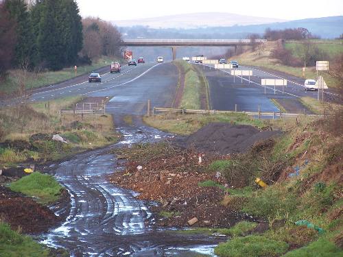
Looking north from M2 junction 10 at Ballymena showing the original terminus prior to 2010. [Photo by Wesley Johnston]
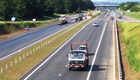
Looking north from M2 junction 10 at Ballymena in August 2010 showing the works to grade separate this junction in their final stages. [Photo by Noel O'Rawe]
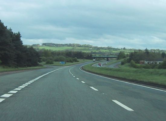
Travelling south on the M2 Ballymena Bypass approaching junction 11 (Broughshane Road) in 2005. [Photo by Wesley Johnston] |


