| Route |
South
from M1 motorway at junction 11 to A3
Northway, Portadown |
| Joins |
M1
motorway
|
| Length |
2.7 km / 1.7 miles
(but see note below under "route
description") |
| Width |
2+2 lanes |
| Opened |
In two phases in 1967
and 1970
(West facing
sliproads opened 1991)
|
| Cost |
£2m (£24.3m in 2005
prices) for original scheme |
| See Also |
M12
on CBRD
Network map
on this site
History of
motorways on this site
|
Built to speed
traffic from the M1 to the new city of
Craigavon, the M12 is instead today a short spur
leading to the A3 Northway in Portadown. This
page has a number of elements:
History |
Junction Map | Construction Timeline | Route Description
Ghost Junction | Traffic Data | Photographs
History
In the 1960s the
Northern Ireland government decided to build a
new city to offset the growing regional
dominance of Belfast and to accommodate the
growing population. The city had to be far
enough from Belfast to be an independent
economical unit, but close enough to encourage
Belfast people to move there. The site
designated in 1965 was the area of land on the
8km / 5 mile stretch between the towns of
Portadown and Lurgan. It was to accommodate two
new centres (called Brownlow and Mandeville) as
well as a new retail core which, combined with
the existing towns, would constitute a new city
with four suburbs. The plan was to run a large
dual-carriageway (known as the Portadown Urban
Motorway, although it was unlikely that it was
planned as a true motorway) from Portadown to
Lurgan along the route of the railway. After the
city was well developed, a second mirror road
would be built on the south side. The M1 was
being built to the north of this whole area and
it was decided to link the two. A road link was
planned to cover the 2.5km distance between the
M1 and the Portadown Urban Motorway. The link
would then extend south between Portadown and
Mandeville and untimately terminate on the B3
Lurgan to Gilford road. Since the north of this
road would lead to the M1, this last section had
to be a motorway, and became the M12. Contrary
to speculation, I don't think there was ever a
plan to extend the motorway restrictions beyond
the Carn junction (j2) as a map from the period
shows several junctions that would be far too
close together for a motorway. I believe the
motorway restrictions were only going to be
applied for legal reasons on the stretch that
led inevitably onto the M1:
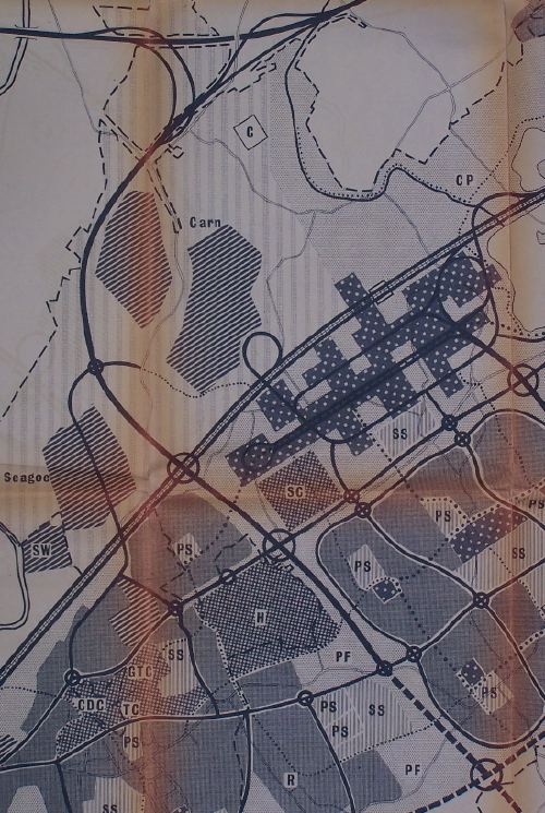
Contemporary
concept plan of the M12 from the M1 (top) to the
Portadown Urban Motorway (double line) and the
extension of the route to the south east.
Portadown is on the bottom left, with Mandeville
to the right. Most of what is shown here was
never built. [From Craigavon New City: Second
Report on the Plan, March 1967].
In the end, the city was a
failure, mostly due to wildly overestimated
population growth figures, and of the two new
suburbs planned, only Brownlow was begun. The
Portadown Urban Motorway was only built from
Portadown to Brownlow and was constructed as an
at-grade single-carriageway road, now the A3
Northway. The M12 was built along with the
east-facing sliproads connecting it to the M1 to
Carn Road and opened in November 1967. The Carn
junction was built as a fully grade separated
roundabout with space for the M12 to pass
beneath. Two and a half years later, the
Northway was extended and a single-carriageway
link road was built from the M12 at Carn to the
Northway via what is now known as Kernan Loop.
This road was never upgraded, and the route has
never been extended any further south. In 1991,
the west-facing sliproads were added. The
necessary bridge had been built in 1967, but had
laid derelict since then. Instead of the
freeflow links planned (see map above), the new
and old sliproads were joined by a roundabout.
This roundabout was inexplicably numbered
junction 1, even though it's really part of M1
junction 11, and the Carn junction renumbered
junction 2.
Junction Map
|
NORTH
Begins at
M1 junction 11
|
|
1.
BALLYNACOR
|
M1 motorway west
|
|
M1 motorway east
|
| |
1.7 km
/ 1.1 miles - 2+2 lanes
|
|
2.
CARN
(originally j1 when built)
|
B2 Seagoe Road
|
|
B2 Carn Road |
| |
Terminates as M12-A3
single-carriageway link road
SOUTH
|
Construction
Timeline
| M1 eastbound to
Charlestown Road |
27 Nov 1967 |
| Charlestown Road to
Carn and on to Northway |
9 Jun 1970 |
| M1 westbound slips
added |
1991 |
Route Description
The length of the M12 is given above as 2.7km.
However, the length depends on how you count it.
The length of 2+2 motorway between the
roundabout at junction 1 and junction 2 is 1.7km
long. The two sliproads from here to the M1
eastbound are part of the M12, even since the
west-facing slips and roundabout were added.
Counted as one road, they are 1km long. And
since we are counting this way, the new
west-facing slip roads, counted as one road, are
0.8km long. So the total length of the road is
3.5km. However, the maximum length that it is
possible to travel in one sequential journey on
the M12 is 2.7km, so that is what is included
above.
Starting on the M1 at Ballynacor, the M12
begins as two sliproads about a mile apart on
some very low, flat land on the River Bann flood
plain. The sliproads all swing south to the 1991
roundabout, junction 1. This is the only
roundabout under motorway restrictions in
Northern Ireland and, while not illegal, is
certainly an anomaly since motorways are
intended to be free-flow routes. There are
currently no plans to grade-separate junction 1.
Coming off the M1 westbound onto the M12, look
out for an area of tarmac on the left that
suggests that there may have been a plan to run
a sliproad off here onto the local road network,
an idea that has been floated periodically since
without much action. There then follows a gentle
curve 1.7km long before we come to junction 2,
Carn, which may have briefly been a terminus in
1970 - I need more information to say for sure.
The road then reverts to a single-carriageway
and squeezes under the west side of the Carn
roundabout bridges. Oddly, the "Start of
motorway restrictions" sign occurs under the
roundabout. Technically, they should begin at
the previous offslip since motorway restrictions
cannot begin at a point where non-motorway
traffic cannot leave the road. The road travels
on for another 800 metres to go round a 180
degree curve and join the A3 at a set of traffic
lights.
Ghost
Junction
There is evidence of an unbuilt "ghost"
junction on the M12 on the sliproads between the
junction 1 roundabout and the M1 to the east. On
the northern sliproad (M12 > M1 eastbound)
there there is a stub on the right for a
sliproad joining from the right. And on the
southern sliproad (M1 westbound > M12) there
is a stub on the left for an onslip. Given that
even today there are people calling for a link
to the local road network from here (presumably
to give direct access to the Rushmere area of
Brownlow) it seems likely that there was once a
plan to build such a junction here. However, the
plan never made it off the drawing board. You
can tell that the plan was very early because it
involved a right-hand merge, a feature that was
included in several early 1960s plans for NI
motorways*, but abandoned shortly afterwards.
Today both stubs are favourite haunts for police
camera traps, but they can't have been designed
for that purpose as mobile speed camera were not
invented then. It is still possible that such a
road link will be built, but at this stage it is
more likely to join the junction 1 roundabout.
*Featured extensively in the Belfast Urban
Motorway plans, and also for the unfinished
M22/M2 junction.
Traffic Data
According to the "Craigavon Council Updating
and Screening Assessment 2006", traffic levels
on the M12 at junction 1 were 20,951 vehicles
per day.
Photographs
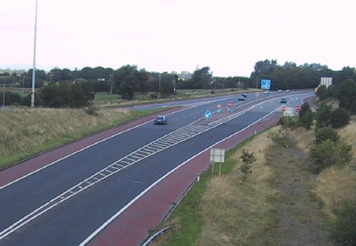
The start of the M12
motorway seen from the junction 2 bridge in
2006. The bridge is wide enough for a full
motorway to pass beneath, so there was clearly a
plan to extend the M12 that never happened.
[Photo by Wesley Johnston]
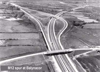
The
M12 junction with the M1 looking west soon after
completion in 1967. Note that Ballynacor is
incorrectly spelt on the image. At this point
the M12 ended abruptly at the B2 Charlestown
Road, and was not extended until 1970. [Image
from the UK Motorway Archive Trust].
|


