|
|
Status
|
Construction scheme
(proposed) |
|
Where
|
To
construct a link road connecting the
Bowtown Road to the Movilla Road round
the east of Newtownards. |
|
Total
Length
|
1.4 km / 0.9 miles
|
|
Dates
|
2007 - Included in
Sub-Regional Transport Plan
March 2009 - Included in adopted Ards
and Down Area Plan
2021 – Developer releases up-to-date
plan for site.
No date for
construction - to be developer led
|
|
Cost
|
Unknown - to be
funded by private developers
|
|
Photos
|
None as yet -
please contact me if you have any to
contribute. |
|
See
Also
|
General
area map - Google Maps
Ards
and Down Area Plan 2015 -
Planning Service
|
Click here to jump
straight down to updates.
The Ards and Down Area Plan 2015, which was
adopted in 2009, foresees significant growth in
housing in Newtownards. The land is divided into
two "Phases". Phase 1 lands must be fully
developed before Phase 2 lands are released. The
bulk of the proposed housing land lies to the
east of the town (Phase 1) and the north-east of
the town (Phase 2). The largest area of land has
the designation NS 19 and is shown on the map
below. A condition of planning is that a
distributor road must be built traversing the
site, connecting Bowtown Road to Movilla Road.
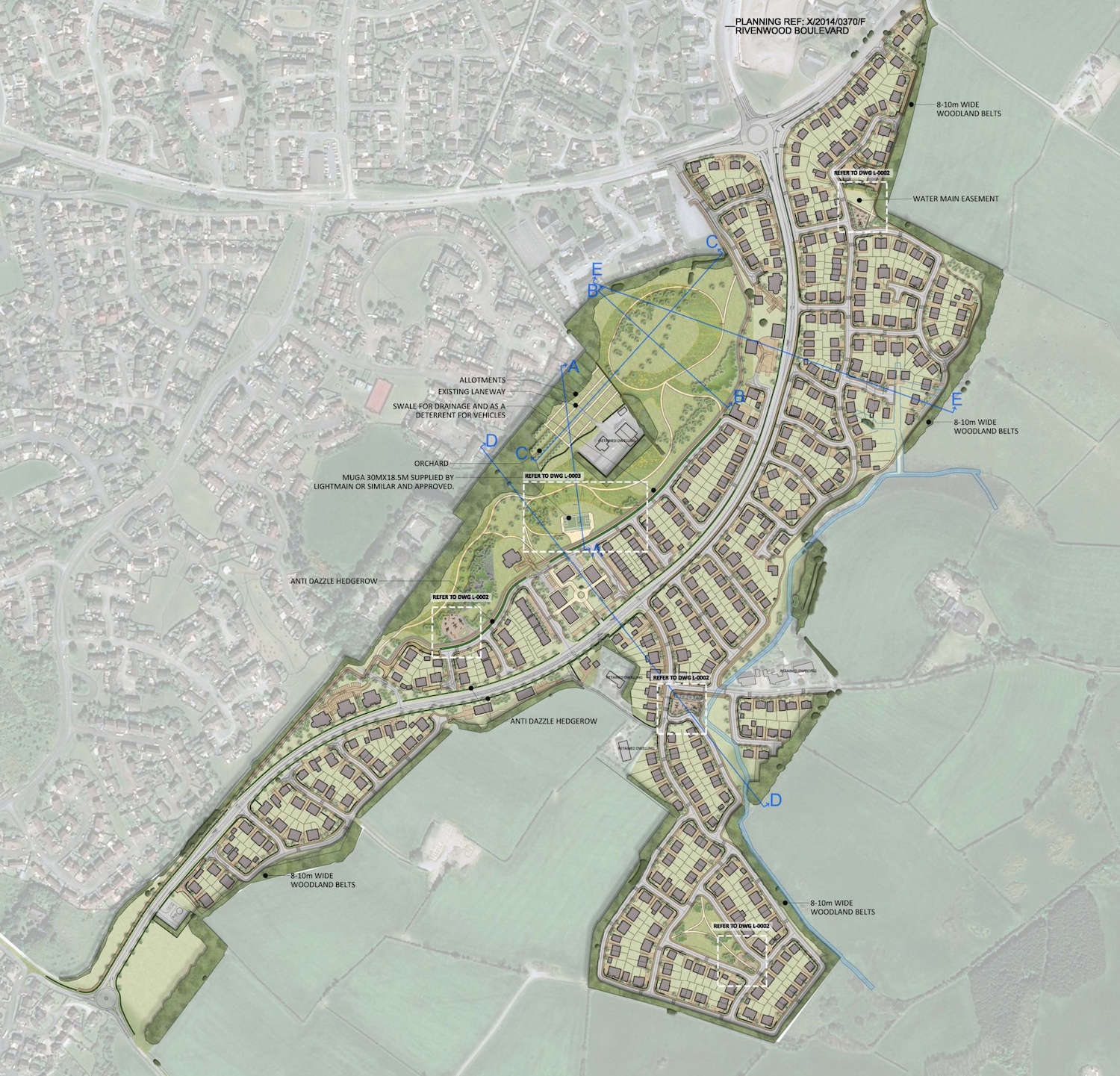
The map below was released in 2021 and shows the
proposed route of the road at that time. The
land to be developed incorporates what was named
"NS 19" in the A&ND Area Plan 2015.
Map, dating from 2021, of the
proposed route of the link road running from
Bowtown Road (bottom left) to Movilla Road (top
right). Image is from Pragma Planning, here.
This scheme ties in to two other schemes that
will, ultimately, lead to the creation of a
partial "ring" road round the east of
Newtownards from the A20 Portaferry Road in the
south to the A21 Bangor Road dual-carriageway in
the north. The two further components that would
be needed to make this a reality are:
Updates
24 May 2024: With grateful thanks to K
Nash for letting me know that Pragma Planning
had published a map of the proposed route of
this link road back in 2021, which I missed at
the time. I have included the map further up
this page. The road largely follows the expected
route, but the most noticeable thing from a
roads perspective is the roundabout at the north
end. The continuation of the road to the north
of Movilla Road is already
under construction, but it meets Movilla
Road at a priority T-junction. This map suggests
that once the fourth arm is added to the
junction it will become a roundabout. Another
roundabout is planned at the terminus on Bowtown
Road.
|