|
|
Status
|
Construction scheme
(future) |
|
Where
|
Construction
of a new single-carriageway bypass of
Armagh connecting the A3 Portadown Road
round the north and west of the town to
the A3 Monaghan Road. |
|
Total
Length
|
6.9km / 4.3 miles |
|
Dates
|
2005 - Included in
Regional Strategic Transport Plan
2006 - More details
in Sub-Regional Transport Plan
Jun 2008 - Preferred
route announced.
Construction after
2015 (as of Jan 2011)
(changed from "by
2013" as of April 2008)
|
|
Cost
|
£55m - £75m as of
April 2010
(changed from £57m as
of June 2008 itself changed from £28m)
Perhaps partly funded
by private developers.
|
|
See
Also
|
General
area map
A28
Armagh East Link on this site
Map
of route - PDF file - the outer,
light blue, route.
|
Click
here to jump straight down to updates
for this scheme.
This plan was introduced in the Regional
Strategic Transport Plan of 2005, but little was
clear as to exactly what it involved until the
Sub-Regional Transport Plan of March 2006 was
published. The road will form a roughly
semi-circular route from the A3 Portadown Road
east of the town round the north and west to the
A3 Monaghan Road in the south west. It will not
only act as a partial "ring road" for local
traffic, but also greatly improve the connection
between Monaghan and the Craigavon and Belfast
areas.
The route originally proposed in the SRTP of
2006 followed the line of the railway line as
far as the A28 Killylea Road. This route would
have had a few issues, including the fact that
it ran through the urban area of the city,
rather than round it, and would have come very
close indeed to St Patrick's Catholic Cathedral.
Roads Service then looked at further options,
including an "out of town" option that was much
longer but lay entirely outside the urban area.
In June
2008 Roads Service announced that they had
decided on this "out of town" option. The
approximate route is shown in this Google Earth
screenshot. See the "see also" links at the top
of the page for a Roads Service map:
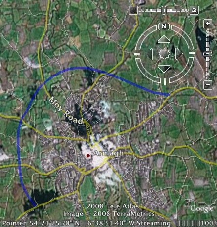
Approximate
route of the proposed Armagh North and West Link
as of June 2008.
The route as
currently proposed will be single-carriageway,
although it's not clear if it will include any
2+1 sections to allow safe overtaking. If it
follows recent design trends, it will likely
feature lots of roundabouts at the points where
it meets other roads. The route is as follows:
- Starting on the A3 Portadown Road close to
the old railway crossing and heads west;
- Crosses the B77 Loughgall Road;
- Crosses the A29 Moy Road, then turns south;
- Crosses the B115 Cathedral Road;
- Crosses the A28 Killylea Road;
- Terminates on the A3 Monaghan Road.
There is a further plan in the pipeline to
build an Armagh
East Link.
Following recent government policy that private
developers should contribute to road schemes
that are required due to their developments, it
is possible that private developers will be made
to foot at least part of the bill for this
scheme. (This is achieved by making it a
condition for planning permission).
Updates
27 Dec 2018: It is just over two years
since my last update, and DFI's position as of
2016 was that "It would not be appropriate to
make a decision on the preferred route at this
time, pending confirmation of proposals for
the Mullinure shared education campus
highlighted in the draft Armagh City Centre
Masterplan 2030". However, since then the
council has selected the site of its new leisure
development (beside the existing leisure
centre), work on the Mullinure housing area is
now underway
and the shared education campus is unlikely to
take place. Therefore there doesn't seem to be a
developmental reason why work on the North and
West Link could not now proceed. The bigger
issue is that the scheme has no funding, and is
unlikely to get any in the near future since the
last Executive established the A5 and A6 as
their key priorities and DFI continues to adhere
to this policy in the absence of a Minister.
9 Oct 2016: This scheme continues to be
frustratingly vague, as it has done since 2011.
In their report
to Armagh, Banbridge and Craigavon Council
in May 2016, TransportNI said "Consideration of
options for a preferred line and junction
strategy based on the ‘out of town’ corridor
linking the A3 Portadown Road to the A3 Monaghan
Road is continuing". Even if this is true, I
think it would be very wrong to think that there
is a team of people somewhere working on this
scheme. More likely it is on hold pending
decisions elsewhere, as the next line implies: "It
would not be appropriate to make a decision on
the preferred route at this time, pending
confirmation of proposals for the Mullinure
shared education campus highlighted in the
draft Armagh City Centre Masterplan 2030".
The Mullinure area is the site of a large
housing development but potentially also a
leisure centre and school site. Such a large
development would certainly need road
infrastructure, so it easy to see why such a
proposal might affect the design of the North
and West Link. However, according to the
notes of a meeting in February, "The
Masterplan process has stalled temporarily due
to issues among the external partners". So
it's not clear when even plans for the Mullinure
area will be put in any final form, leaving any
further development of the Armagh North and West
Link very vague indeed. I would not expect to
hear much more on this for at least a couple of
years.
18 Sep 2014: It's been nearly four
years since the last update to this scheme, and
it's now looking as if it has been put on hold.
In
the Assembly on 8 September, the DRD
Minister said that continued consideration of
the design of the Armagh North and West Link now
involves "discussions with Deloitte, which
has been appointed by Armagh City and District
Council to develop a master plan for the
Mullinure area" and goes on to comment
that "it would not be appropriate to make a
decision on the preferred route pending
development of the master plan". The new
super-councils come into existence on 1 April
2015 and these councils will take over
responsibility for planning. This means that
from April 2015, councils will have a much
greater input into area plans than hitherto.
While the DRD will still be responsible for
roads, they do appear to be responding to this
new reality by accepting an increased role for
the councils when developing road proposals
within urban areas, in this case Armagh. So I
would speculate that we will not see many
further announcements on this scheme until the
aforementioned master plan has been published.
14 Jan 2011: The timetable for
this scheme was always rather vague (in 2008 it
was to be built by 2013). But the draft
Roads Service budget revealed yesterday
makes it clear that it cannot be built before
2015.
2 May 2010: Roads Service's
web site is saying that Amey Consulting are
currently working on a specimen (initial) design
for the road. The cost has also been revised
from £57m as of 2008 to the range £55m-£75m.
24 Nov 2008: Roads Service have
released a leaflet about this scheme. The
leaflet does not really tell us anything new,
but it is a good summary of the scheme and
confirms that it is still being considered for
construction "within five years".
27 Jun 2008: In this
press release on 24 June Roads Service
announced their preferred route. The route is
the "out of town" route, completely different
from the route initially proposed in 2005. The
original route ran along the route of the
railway line and was 3.8km long. This new route
runs some distance further out from the city on
an entirely new route and is almost double the
length at 6.9km. This has resulted in the cost
more than doubling to £57m. It's not yet known
where the junctions along the route will be
located. Roads Service are giving the start of
construction as "within five years".
28 Apr 2008: The strategy
document "Investment Delivery Strategy for
Roads" of April 2008 gives the timescale of this
project as 2008-2013, but is not any more
specific than this, implying that the date may
be towards the 2013 end of the time period.
Nov 2006: In the Roads Service
report to Armagh Council on 13 November 2006,
Roads Service said that "as a result of public
consulation" the area of study has been expanded
to consider other route options. This implies
public disattisfaction with the route as
proposed above.
|
