|
|
Status
|
Construction scheme
(future) |
|
Where
|
To
connect the A28 Markethill Road, Armagh
to the A3 Portadown Road via the A51
Hamiltonsbawn Road. |
|
Total
Length
|
2.2 km / 1.4 miles
|
|
Dates
|
Proposed in Armagh
Area Plan - 2004
Public information day held - March 2006
Stage 1 Assessment completed - August
2006
Preferred Route
Announced - 20 March 2007
Scheme approved in principle - 14 Nov
2011
Stage 2 Approval given - Mar 2012
Public consultation event and review
announced - 11 June 2014
Repeat Stage 1 Assessment completed and
repeat Stage 2 assessment begun - by May
2016
Repeat Stage 2 Scheme Assessment
completed - Aug 2019
|
|
Cost
|
£18.5m as of Aug
2019
(changed from £24.6m as of Nov 2011
and £6.0m as of Nov 2006) |
|
Photos
|
None as yet -
please contact me if you have any to
contribute. |
|
See
Also
|
General
area map - Google Earth
Official
web site on scheme - Roads Service
Armagh
North and West Link on this site
|
Click
here to jump straight down to updates
for this scheme.
The Armagh East Link is proposed to connect the
main A28 route (from Armagh to Newry and Dublin)
to the main A3 route (from Armagh to Portadown
and Belfast) without having to go into the city
centre. It complements the Armagh North and West
Link which is in a more advanced stage of
planning - see link above. Construction of the
scheme is not anticipated in the short term at
the time of writing (April 2012) but work is
progressing well.
Route
The route as adopted in 2007, and confirmed in
2019, uses existing roads in two places - the
Ardmore Road in the south and part of
Hamiltonsbawn Road Industrial Estate in the
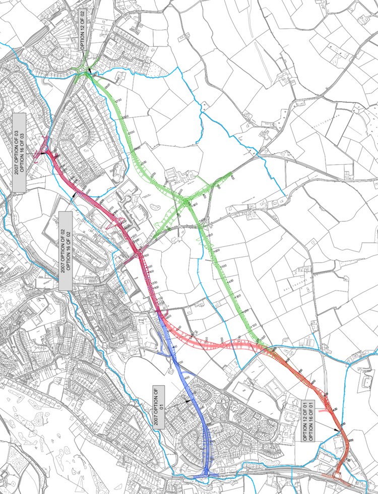
north. The map below also shows the
three routes considered in 2019 - the chosen
route is shown in blue. The red and green routes
were considered but rejected as too expensive
for the benefits gained.
The official DFI Roads description of the route
is as follows:
"This option commences at the junction of
A28 Markethill Road and Ardmore Road to the
south, extending northwards to the proposed
junction with A3 Portadown Road west of
Linsey’s Hill. This option utilises the
existing Ardmore Road, the road through
Hamiltonsbawn Road Industrial Estate and part
of Linsey’s Heights Road. This option provides
a junction with A51 Hamiltonsbawn Road and is
likely to incorporate a staggered junction to
facilitate access to Ballynahonemore Road."
Updates
6 Oct 2022: This scheme continues to
languish far down the pile. One reason for the
languishing is that DFI have been working on new
transport plans for the past couple of years,
and this is one of the schemes in review.
However in their latest
report to Armagh, Banbridge and Craigavon
Council DFI did comment that the scheme is being
"considered" for inclusion in the Mid South West
Growth Deal which is still at the planning
stage. This means that there is a chance the
project could happen within the next ten years.
21 Sep 2019: DFI published
their Stage 2 assessment of the scheme on 20
August 2019. As a reminder, this is the *second
time* the Stage 2 assessment has been carried
out. The last time was in 2012, but the work has
been re-done due to the time that has elapsed,
and also as a result of public feedback which
wanted DFI Roads to consider a route termining
further to the east at the south end, near
Edenaveys Industrial Estate, rather than in the
more residential area around Ardmore Road. DFI
have now looked at three options - shown on the
map above. The first of these, the "blue" route,
is the same 2.2 km route considered and approved
in 2012. The second one, the "red" route, starts
in the same place at the north, but then curves
more the east to end at Edenaveys. It's thus
longer at 3 km. The third one, the "green"
route, shifts the entire route further to the
east at both the north and the south. It also
includes, for unclear reasons, a local
realignment of the A51 Hamiltonsbawn Road part
way along. This route is 2.9 km long. The report
then carries out a benefit/cost calculation for
each route. The costs are the design costs +
land costs + planning costs + construction
costs. The benefits are the economic benefits
over 15 years to members of the public +
benefits to business + savings from fewer
crashes. The idea is that the benefits should
outweigh the costs. It's presented as a ratio of
benefits/costs (the BCR), so any figure above 1
indicates a scheme that brings more benefits
than it costs. The results were: Blue route
1.359; Red route 0.958; Green route 0.388. That
means that only the blue route is "worth
building" from an economic point of view, though
a ratio of 1.359 is itself not huge (it means
there will be £1.36 of benefits over 15 years
for every £1 spent on it). At the same time, the
total cost of the blue route is now estimated at
£18.5m, which is actually less than the figure
of £24.6m quoted in 2011. DFI have, therefore,
decided that the original route is still the
correct one. Finally, it should be pointed out
that there is currently no funding for this
scheme, and no indication that it is even on the
radar for funding, so I would not expect to see
any movement toward construction in the near
future.
14 Oct 2017: The DFI's most recent
report to Armagh,
Banbridge and Craigavon Council in
September 2017 appears to be largely a
copy-and-paste job from the May 2016 report that
I quoted in the previous update. It says pretty
much the exact same thing, except that the
"Stage 2" report is now due to be completed in
"summer 2017" rather than "autumn 2016" as they
said last year. The only thing that has been
added is a somewhat vague promise that "a
public event will be scheduled over the coming
months". All of this gives me the
impression that very little is actually
happening with this scheme, which does not
appear to be a priority within DFI, expecially
given the Executive's stated focus on the A5 and
A6.
9 Oct 2016: In their report
to Armagh, Banbridge and Craigavon Council
in May 2016 TransportNI gave us an update on
this scheme. To recap, a preferred route was
finalised 2007 but it was not built. In June
2014 there was a public consultation event which
was probably intended to get public endorsment
for revisiting the design, since the standards
we have for bypasses today are much higher than
they were even ten years ago, and tend to
involve fewer junctions and greater distances
from the built up area. The evolution of the A31
Magherafelt and A29 Cookstown Bypasses are good
examples. The review has been ongoing, probably
at a fairly relaxed pace, since then.
TransportNI have now said that the review is
complete and that it "included consideration
of the preferred corridor emerging further out
the A28 Markethill Road at the Edenaveys
Industrial Estate and has identified viable
alternative options". They then say that "are
now subject to a stage 2 assessment before a
preferred option can be confirmed. It is
anticipated that this assessment will be
completed in Autumn 2016". Note that it
does not say that anything will actually be
revealed to the public once the stage 2
assessment is completed. Given that the
Infrastructure Minister seems keen on
progressing the A5 and A6 schemes as his highest
priority, and that he has explicitly mentioned
two other bypasses (Enniskillen and
Ballynahinch) that he wants to build, my feeling
is that provision of this road is still some
years in the future.
8 Jun 2015: The DRD Minister was asked
about this scheme via a Written
Answer in the Assembly in April 2015. As
noted in the previous update, TransportNI held a
consultation event in June 2014, the tone of
which made it obvious that they wanted to
revisit the design of the scheme. They do indeed
seem to have been carrying out review work: in
his answer, the DRD Minister said "my
officials have been carrying out a review of
the Preferred Corridor for the proposal. This
review, which has included updating the
traffic and environmental surveys, is expected
to be completed in the coming months".
Past experience shows that when the DRD Minister
says "the coming months", it can actually mean a
year or more, so I wouldn't expect anything
imminently. He also says that the cost is now
estimated at £12-20m, which is actually less
than the figure of £24.6m that was being quoted
in 2011 which is strange given that road scheme
costs tend to rise with time, not fall. But we
shall have to wait and see what emerges from the
review process.
5 Sep 2014: In my update in June
(below) I commented that the public exhibition
didn't say much new and seemed geared towards
creating public awareness of a scheme that has
been parked for several years. However it seems
that the exhibition resulted in negative
feedback for the designers from local residents.
This is based on a press
release issued today where the DRD
Minister has said that the preferred route will
be "reviewed" in light of this feedback, and in
particular that it "will include
consideration of the preferred corridor
emerging further out the Markethill Road at
the Edenaveys Industrial Estate area". It
also notes that it will "include updating
key project information such as traffic
volumes and environmental surveys".
Reading between the lines here, it looks to me
as if this scheme has sat at the design stage
for so many years (the preferred route was
announced in 2007) that the scheme design is no
longer appropriate to current policy, especially
in terms of the proximity to housing and the
design standard now favoured for roads of this
type. In the past ten years Roads Service (oops,
I mean TransportNI) has tended to move away from
building distributor roads that run close to an
urban area and have lots of junctions, and
towards roads that are of a higher standard, run
further from the urban area and have fewer
junctions. We have seen this happen as the plans
for the Magherafelt Bypass and the Cookstown
Bypass have evolved, and the same thing may be
happening here. Running the link along Ardmore
Road, even though it was designed to eventually
form part of the East Link, may no longer be
considered appropriate due to there being
several T-junctions along this stretch leading
into housing estates. It's possible that a
review of the design of the scheme was actually
TransportNI's preference, and that the purpose
of the public exhibition may therefore have been
to seek support or confirmation for this line of
reasoning.
16 Jul 2014: In my previous update I
suggested that "Roads Service are keen to
progress the scheme", and there has now been
further evidence to support this. The DRD seems
to have moved this scheme from the "forward
planning schedule" to the "preparation
pool" (although it now appears in both
lists!). The former are schemes that are planned
for the longer term, but aren't expected to be
built soon, where as the latter are expected to
proceed to construction within a few years. In
practice, schemes can sit in the preparation
pool for years and years, and even then require
a funding allocation before they can be built,
so it probably doesn't really tell us anything
about timescales for this particular scheme.
Coupled with the public consultation in June,
which in practice seems to have been nothing
more than a "raising awarenes" exercise, this
makes me think that this scheme is now rolling
once again and that we will see further planning
milestones met over the next couple of years.
19 Jun 2014: The public
information event on 11th June was a
presentation of the preferred route. Although
this preferred route was identified over two
years ago, and is available
on the DRD web site, the leaflet given out at
the event said that a key objective of the
exhibition was to "increase public awareness
of the project". Although it is still on the
Forward Planning Schedule (which normally
means that construction is at least 5 years
away), this suggests that Roads Service are
keen to progress the scheme. However the
leaflet, which is not yet available online,
doesn't indicate any timescale. It does
indicate that the draft legal orders are the
next stage, as they are with any scheme. These
are the Environmental Statement (which
outlines the reasons for the scheme, its pros
and cons and is usually the subject of a
public inquiry), the Direction Order (giving
DRD permission to create a new "trunk road")
the Vesting Order (allowing DRD to compel land
owners to sell the necessary land) and the
Stopping Up Order (needed to give DRD the
power to close current private accesses onto
the new road, which is often done for safety
reasons or if roads are being diverted). The
only new information in the leaflet that I
have not seen before is the design of the
three junctions. So the junction with the A3
Portadown Road will be a roundabout, while th
ejunctions with the A51 Hamilstonsbawn Road
and the A28 Markethill Road will both be
controlled by traffic lights. Also, it says
that a short 300 metres stretch of
Hamiltonsbawn Road will be realigned to remove
a sharp bend on the approach to the new
junction, presumably to provide better forward
visability.
7 Jun 2014: According
to Roads Service, a public consultation event
into this scheme is going to be held on
Wednesday 11 June 2014. It will take place in
the Armagh City Hotel from 11.30am to 8.30pm.
This scheme is still in the forward planning
schedule, which usually means that it's not
expected to proceed to construction in the near
future. However, we do know that the "State 2
Assessment Report" for the scheme was aproved
two years ago (see previous update). This it's
Roads Service speak for "we've picked the
preferred route", which you can see by clicking
here. So it's not clear to me why there's
a public consultation event now, two years after
this, unless some further progress has been
made. I commented in the previous update two
years ago that this scheme appeared to be being
pushed up the schedule for an unknown reason,
and this still seems to be the case. It will be
interesting to see what, if anything, new is
presented at the event and whether it sheds any
light on the scheme. The Roads Service web
page on the scheme is still quoting the
cost as £12-20m even though the Roads Service
Board estimated the cost to be closer to £24m
back in 2011 (see update for 6 Apr 2012 below).
22 April 2012: The DRD
web site is now also saying that the Stage
2 Assessment Report was approved by the Roads
Service board on 5 March 2012, although neither
the minutes nor the report itself have been
published online yet. This comes just four
months after the Stage 1 Report was approved,
even though nothing much had happened on this
scheme for the prior six years. All the signs
are that this scheme is being pushed up the
schedule for an unknown reason - perhaps with
Roads Service under pressure to spend the money
reallocated from the A5 scheme, they are casting
about for schemes that could go ahead at
relatively short notice to spend the money.
Perhaps they are anticipating that this scheme
will not require a Public Inquiry.
6 April 2012:
According to the Minutes
of a Roads Service board meeting held in
November 2011 (but just published), this scheme
was given "Gateway 0 Approval" in mid November
last year. The text is worth quoting in full: "noted, on 14
November 2011, the approval of the Stage 1
report for Armagh East Link and granted
Gateway 0 approval noting the estimated cost
of £24.6 million and that potentially the
scheme could be delivered within the current
Budget period". The Stage 1 report that
is referred to is now available on the Roads
Service web site here.
However this document was written in August
2006, ie six
years ago. This
implies that the scheme has been sitting on hold
for all of this time but has now finally been
approved. "Gateway 0" approval means that the
scheme has passed its "Strategic Assessment", ie
it has been approved in principle, but that the
detailed design work has yet to take place. The
cost of £24.6m is over four times more than the
figure of £6m given in the document "Expanding
the Strategic Road Improvement Programme"
published in November 2006, and three times the
cost of £7.6m given in the Stage 1 Assessment
Report. The reason for this huge cost escalation
is not clear. In terms of timescale, Roads
Service are officially saying that it is timed
for construction within "5 to 10 years". In
practice this is what they say about almost
every scheme in the forward planning schedule.
However the comment in the minutes that it "could be delivered
within the current Budget period" is
interesting, since the "current budget period"
only takes us up to around 2015. We shall have
to watch this space to see what this might mean.
|