|
As one of Northern Ireland's two major ports (the other being Belfast) Larne has a disproportionately impressive roads infrastructure. Every time a ferry arrives at the port from Scotland, dozens of lorries depart to various locations across Ireland along the A8. Since the port is close to the town centre, the Roads Service built the A8 dual-carriageway which carries traffic from the rural A8 down the hill bypassing the town centre and leading directly to the port on a series of flyovers. The road is built to dual 2-lane standard without hard shoulders on much of the length. There are a variety of roundabouts, priority junctions and traffic lights on the route.
In January 2004 two new roundabouts were opened at Antville and Millbrook on the A8 to allow local traffic to turn onto the dual-carriageway more safely. The Antville roundabout, which is on the steep
climb north out of the town, features a filter lane so that lorries that have managed to build up speed as they head up hill do not have to stop. The photo below shows an aerial view of this roundabout.
Given that dualling of the south end of the A8 is ongoing, and that the A8 is designated European route E001 there is currently political pressure to dual the whole route. This probably will happen before too much time has passed, but probably not before 2015. Having said that, I travel on the A8 regularly and do not find it particularly slow. Dualling the A4 and A6 should probably take priority.
There is another dual section of the A8 at the southern end of the route. See links above.
Photos
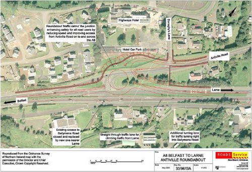
This aerial photo of the A8 at Antville near Larne is superimposed with the Roads Service plans for the roundabout that was completed in 2004. [Photo from DRD Roads Service web site]
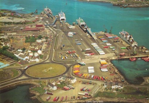
The A8 dual carriageway is visible in the bottom left here where it meets Larne harbour [picture taken from Larne Ferry Web http://www.larneferryweb.com/Larne_Harbour_pics.htm, ultimately from Larne Harbour handbook] Picture taken in late 1980s.
|
