|
This page is supplementary to the main page
about this scheme and holds older site
updates.
Progress
(21 December 2019 and earlier)
21 Dec 2019: The contractor has not been
putting up videos on YouTube much recently,
perhaps because the videos were more for keeping
track of excavations than for public interest,
but it does mean I have had a bit more of a
struggle to keep track of what's going on. This
update is pieced together from various Tweets as
well as this
update posted on the contractor's web site
earlier in December. Firstly, although the
Randalstown to Toome section is essentially
complete, the footprint of the former road at
the Randalstown West junction has now become a
borrow pit - so it's being excavated down to
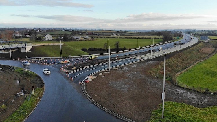
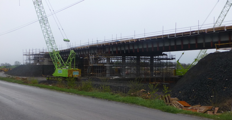
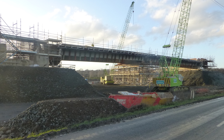
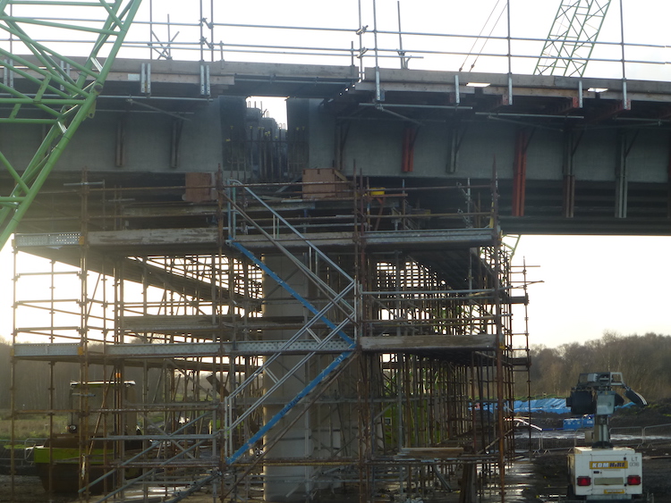
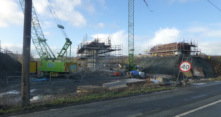
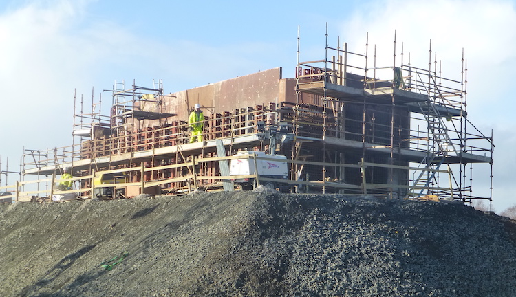
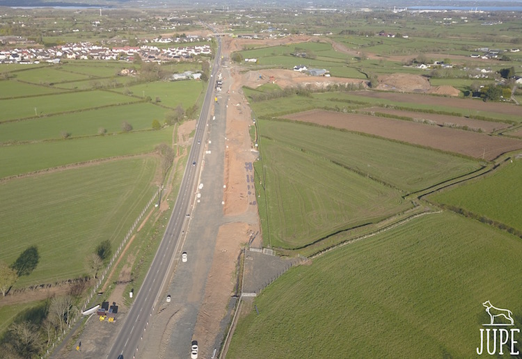
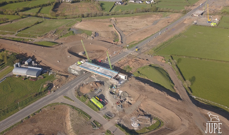
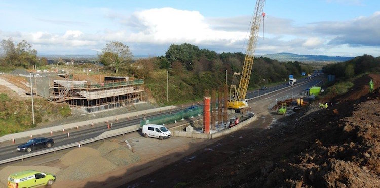
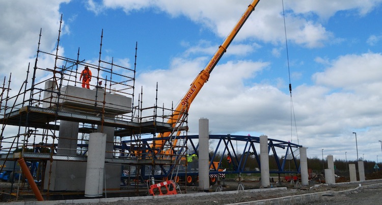
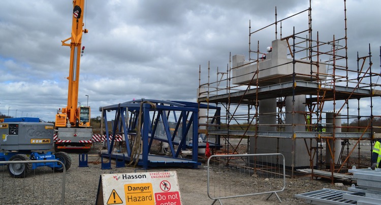
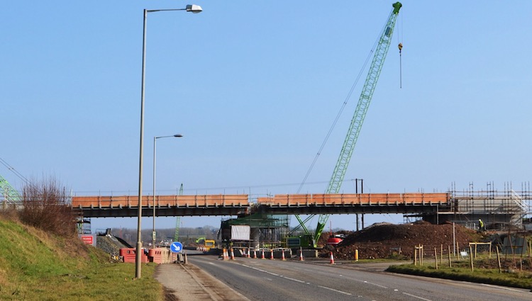
quite a depth - see pic 1 below. Secondly, work
continues to progress at the three new
grade-separated junctions on the offline stretch
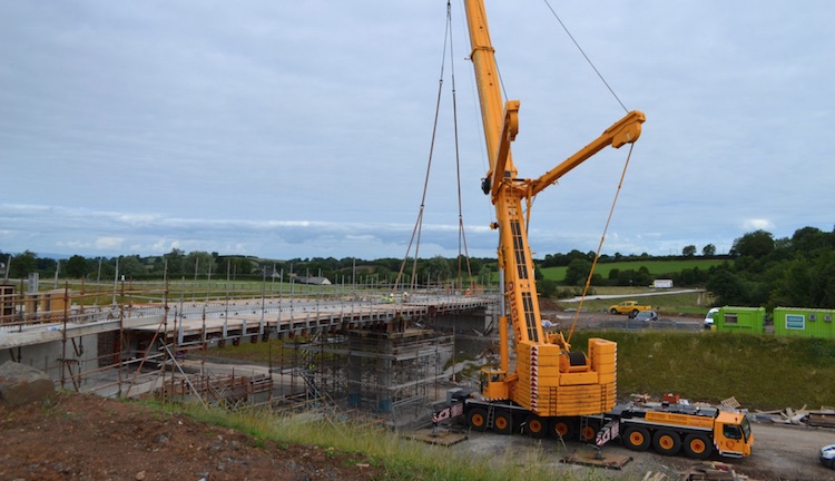
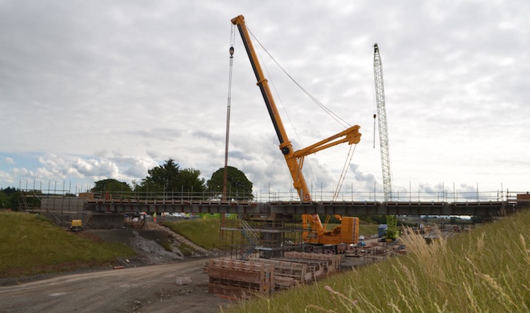
between Toome and Castledawson. The bridge at The
Creagh is well advanced, with the bridge
deck under construction. This bridge is not on
any existing road, so will probably not open
until the new dual-carriageway opens. The nearby
Deerpark Road flyover, however, replaces
the existing Deerpark Road which currently runs
beside it. Deerpark Road will therefore need to
be closed for 8 weeks during the spring of 2020
to allow the road to be realigned over the new
bridge. Something similar will happen at the Hillhead
Road junction (eastern access to
Castledawson) which will be closed from 21
January until late March to allow the road to be
realigned over the new flyover there. No major
work is currently taking place on the stretch of
new road between The Creagh and Deerpark Road,
due to environmental restrictions close to Lough
Beg, but work continues between Deerpark Road
and Hillhead Road (see pic 2 below) where the
formation of the new road is becoming much
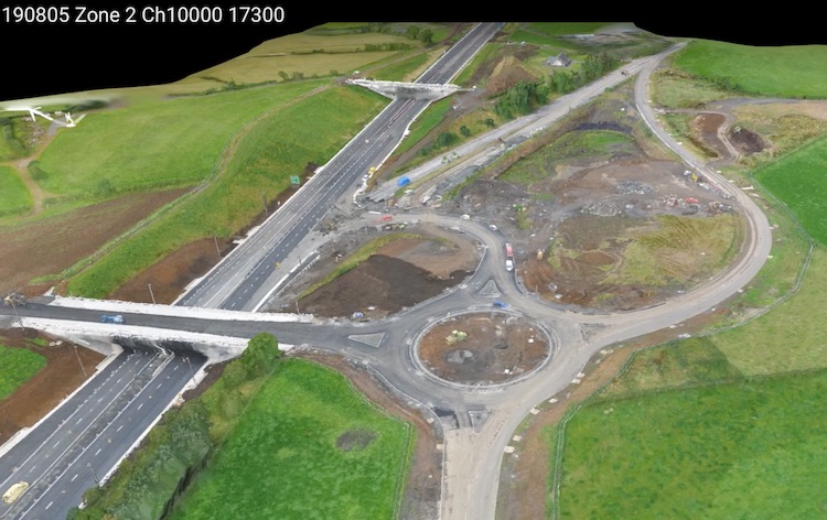
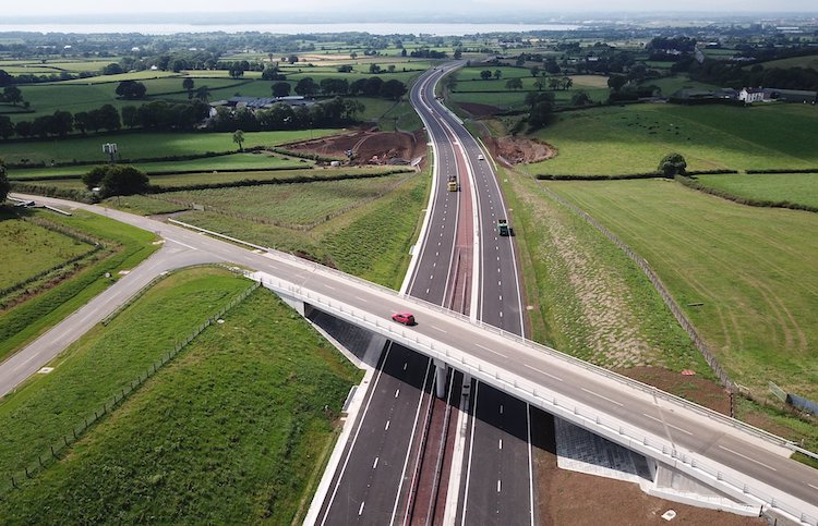
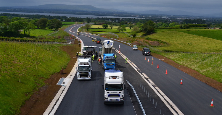
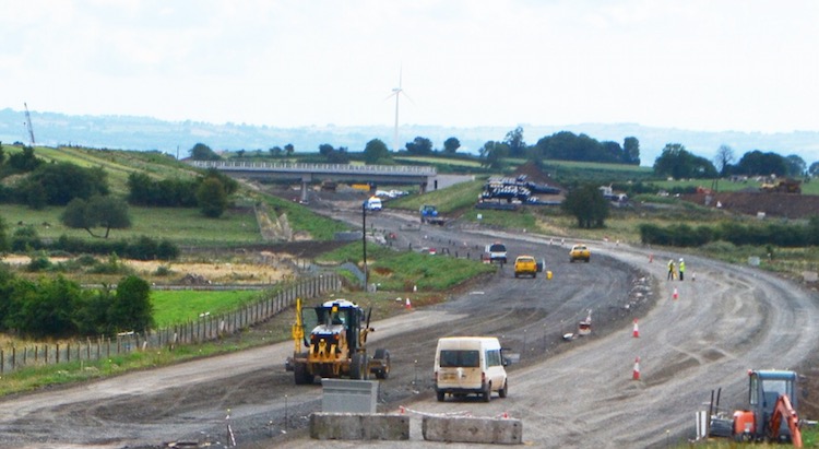
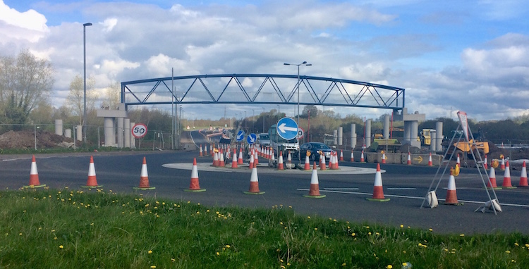
clearer. On the Castledawson Bypass, all
traffic switched to the future eastbound
carriageway at the beginning of December (a week
later than planned; see pic 3 below) to allow
further work on the westbound carriageway. At
the same time, the new Bellshill Road/Annaghmore
Road grade-separated junction opened to traffic,
albeit with Give Way arrangements rather than
onslips "for ten months" (pic 4 below). This
mention of "ten months" by the contractor
implies that it will be at least the autumn of
2020 before all four lanes of the Castledawson
Bypass open to traffic. In other news, the A6
scheme won
a Green Apple Environmental Award from The
Green Organisation - the scheme got Bronze award
in the Building and Construction category.
Contratulations! Finally, the NI Audit Office
has included this scheme in a recent
report into major capital projects and
gives the estimated total cost of the scheme as
£189m, well up on the £160m being quoted in
2016. The NIAO estimates that the unsuccessful
legal challenge to the scheme added
approximately £11m to the cost of the scheme and
a year to the construction timescale. Anyway,
Happy Christmas, and here are the pictures:
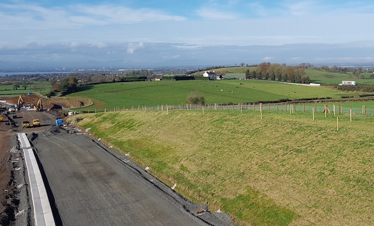
Pic 1: Aerial view of the completed Randalstown
West junction in mid December 2019, showing the
line of the former road on the right now being
used as a borrow pit. The jew junction is
already maturing with vegetation covering the
new banks. [Still from this
YouTube movie]
Pic 2: Computer-generated aerial view of the new
dual-carriageway under construction between
Castledawson and Toome in mid December 2019.
This is the view east from close to the Hillhead
Road junction, with the Deerpark Road junction
off frame ahead. The large area of exposed earth
on the left is another borrow pit, which appears
to now be being filled in again. [Still from this YouTube
movie]
Pic 3: View of the terminus of the scheme at the
Castledawson Roundabout during the switchover
from the westbound to the eastbound carriageway
(the more distant of the two here) at the start
of December. [Graham Farrans image from here]
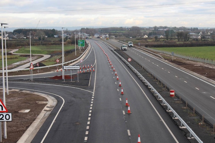
Pic 4: View east along the new A6 Castledawson
Bypass from the new Bellshill Road flyover,
showing the eastbound offslip now fully open,
and the onslip partly open. All traffic is
currently using the future eastbound
carriageway. Note the nice V-shaped gully on the
left edge of the road. Note also the concrete
accommodation lane visible in the top left.
[Graham Farrans image from here]
9 Nov 2019: With work on the Randalstown
to Toome section now essentially complete,
attention is focused on the more complex stretch
from Toome to Castledawson. From 28 October
traffic on the Castledawson Bypass was switched
from the future westbound carriageway onto the
future eastbound carriageway once again to
facilitate final surfacing works. Work has also
been ongoing throughout October to complete the
Annaghmore Road/Bellshill Road junction and from
the same date (28 Oct) local traffic was able to
use the new flyover but without access onto the
A6. Annaghmore Road South was permanently
stopped up at the same time, while the Bellshill
Road North will be closed permanently from next
month. At some point soon Annaghmore Road North
will presumably also be closed, with access via
the new junction. The contractor has said that
the plan is to open the stretch from Hillhead
Road junction (near the new footbridge at Brough
Road) to Castledawson Roundabout fully prior to
the rest of the road, but that this won't be for
"some time" yet.
Major works are now suspended for the winter on
the stretch of the site passing close to Lough
Beg due to the presence of overwintering swans,
but work can continue on the rest of the scheme,
especially the offline stretch from Hillhead
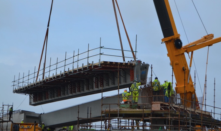
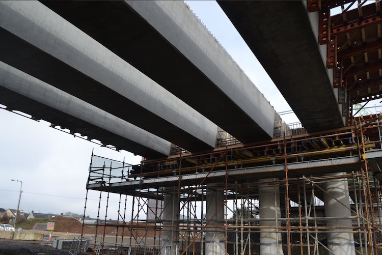
Road in Toome to Deerpark Road. The bridge beams
for the Hillhead Road bridge, the last bridge to
get its beams, were lifted into place during the
week of 7 October - see photo below. The
contractor has not posted any aerial footage on
YouTube for a month now, which is disappointing.
However, Google Earth have updated their imagery
of the area, though it's only visible in
"historical mode" on Google Earth. You can now
see the site as it was on 26 August this year.
I'm not posting any screenshots, as that's over
two month ago and hence out of date, but do
check it out if you're interested. In other
random bits of news - (1) The scheme has
apparently won an "environmental award", with
DFI to receive it at a ceremony later in
November. (2) The scheme will appear in the next
season of the engineering series Ulster
Giants. Filming took place in October.
The whole scheme is due to be completed by
early 2021, so a little under a year and a half
to go.
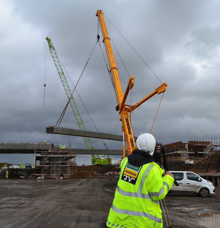
A member of camera crew filming a beam lift
(possibly Hillhead Road, Castledawson) in
October 2019 for the next season of Ulster
Giants [DFI image].
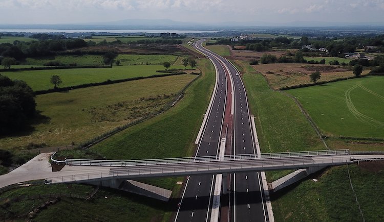
21 Sep 2019: The "official" opening of
the new section of dual-carriageway from Randalstown
to Toome, which opened to traffic on 4
August, took place on 12 September. Unusually,
because there is currently no Executive, it was
opened not by the DFI Minister but by Katrina
Godfrey, Permanent Secretary of DFI, plus two
local schoolchildren (see pic below). Two
children (Juliet Murray and Grace O'Botle) wrote
poems about the road - the first poems I have
seen specifically written about a new road -
which you can read at the bottom of this
page (along with pictures and quotes from
various people involved in the scheme). Thank
you to them! The opening coincided with the
re-opening of the new Randalstown West
grade-separated junction at the western end of
the M22 where the new A6 begins.
Disappointingly, the junction seems to have lost
its junction number - it was M22 junction "3"
when it was a T-junction, but seems to have no
number now that it has a flyover and sliproads!
There was a bit of negative
publicity after the opening due to the
appearance of long traffic jams westbound at
Drumderg roundabout in Toome. Some concluded on
the basis of this that the road should not have
been built. Two points on this. Firstly, the
decision to leave Drumderg roundabout and
Roguery Road roundabout in-situ on the Toome
Bypass was a poor one, and one which I suspect
DFI already know was a mistake. The decision was
taken ten years ago when policy was different,
but with all the legal controversy around the
road during the planning stages, DFI will not
have wanted to revisit the design. The decision
will continue to haunt us, I suspect, for the
next ten to twenty years as this has created a
new "Hillsborough Roundabout" situation.
Nevertheless, I am also told that much of the
congestion we saw at Toome was caused by the
ongoing roadworks on the Castledawson end of the
scheme. With local road closures, many people
are going though Toome village and using the
back roads to Magherafelt. This traffic can't
all squeeze through Toome, so is backing up onto
the Drumderg roundabout, interfering with
Derry-bound traffic. This problem should
mitigate once the remainder of the scheme is
open. All of this, of course, ignores the fact
that the new road is substantially safer than
the old Moneynick Road - the fatality rate on
A-class dual-carriageways is approximately half
that of A-class single-carriageways.
All attention now focuses on the Castledawson
to Toome stretch which is due to open in
about 18 months' time. As always, the best way
to get an overall view of the scheme is to watch
the latest
aerial movie. I've provided a brief commentary
below, where numbers refer to the minutes and
seconds in the video.
0:00 Starting at Castledawson roundabout, where
the footpath connecting the two footbridges is
well developed.
0:02 Start of Castledawson Bypass. All traffic
is using the future westbound carriageway, which
is already completed. Work on the future
eastbound carriageway is well advanced.
0:12 New agricultural accommodation lane visible
on right. These generally have concrete
surfaces.
0:20 Future westbound layby.
0:24 Annaghmore Road, which is to be permanently
closed after completion.
0:39 Future Annaghmore/Bellshill Road
grade-separated junction looking close to
completion with road surfacing being laid.
0:52 Moyola River bridges - original 1992 bridge
on the left, new bridge on the right.
1:03 Point where the new road diverges from the
current A6. New footbridge visible.
1:16 Future Hillhead Road grade-separated
junction with bridge abutments and central pier
under construction, but with the bridge beams
yet to be placed.
1:33 Foundation of new road now in place on this
cross-country stretch.
1:51 Deerpark Road junction with the approach
embankments in place, plus the curved embankment
(lower left) for the east-facing sliproads. The
existing Deerpark Road runs beyond the bridge.
It needs to be diverted up onto the bridge
before the west-facing sliproads can be built
(on the site at upper right).
2:00 This stretch runs close to Lough Beg and
will be off-limits to the contractor from
October due to overwintering swans. The
foundation of the new road are well-advanced
here.
2:11 New farm accommodation bridge in place, but
as yet without approach embankments. The huge
borrow pit that was dug in Aughrim Hill (on the
right) has now been largely filled in again. It
will be restored to its former appearance once
work is completed.
2:20 Farm accommodation underpass.
2:25 Farm accommodation overbridge with approach
embankments underway.
2:34 The Creagh grade-separated junction. The
bridge beams were lifted into place a couple of
weeks ago. A short length of new road will
connect it to the existing Creagh roundabout,
off frame to the right.
2:45 Road re-joins existing Toome Bypass. The
existing Toome Bypass from here to Creagh
Roundabout will be reduced from a
dual-carriageway to a single-carriageway.
2:53 New SuDS detention pond visible at lower
left - this stores water during a heavy rain
event and releases it slowly, preventing flash
flooding of local watercourses.
2:55 Hillhead Road T-junction, at Toome. Access
to Toome here will be closed off, and instead
Toome will be connected directly to The Creagh
roundabout via a new single-carriageway, which
all traffic is currently using, visible on the
right here.
Finally, there is always space for photos,
so here are some!
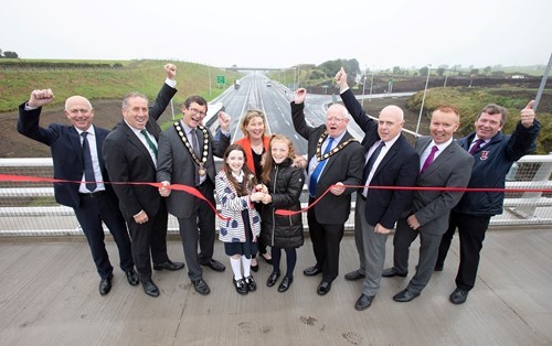
Official opening of the A6 between Randalstown
and Toome on 12 Sep 2019, taken from Randalstown
West bridge. [DFI Roads image]
Beam lift at The Creagh grade-separated junction
on 6 Sep 2019 (with current A6 and Creagh
roundabout visible beyond). [DFI]
Aerial view of the first beam being lifted into
place at The Creagh on 6 Sep 2019. Note the
falsework (in red) already attached to the site
of the beam - this is a walkway for workers to
use once the beams are in place. [DFI]
Another view of the first beam being placed at
The Creagh on 6 Sep 2019. The route of the
future dual-carriageway towards Deerpark Road is
visible going into the distance, with the
wetlands around Lough Beg beyond the fields on
the right. [DFI]
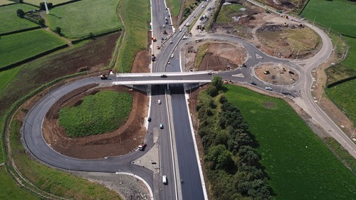
View of the new Deerpark Road flyover, from the
existing Deerpark Road, on 13 Aug 2019. The
photographer is standing where there will
eventually be a curved embankment to carry the
west-facing sliproads. However, this cannot be
started until Deerpark Road has been diverted up
and over this new bridge. [Arthur Ming]
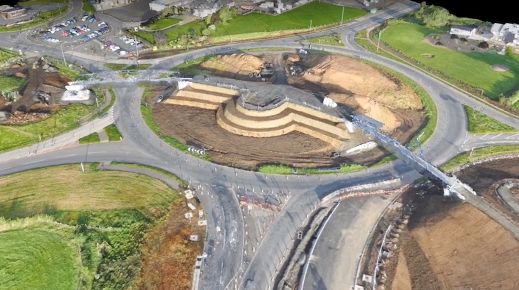
Computer-generated 3D aerial view of
Castledawson roundabout as it was c19 Sep 2019,
showing the two new bridges in place and the
earthworks for the central sculpture and walkway
in place. The new A6 is to the bottom, with the
existing A6 towards Derry to the top right, and
the new A31 Magherafelt Bypass to the left.
[still from Graham/Farrans aerial movie]
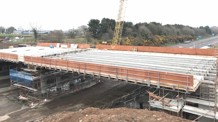
16 Aug 2019: The first half of this
scheme – the new section of dual-carriageway
from Randalstown to Toome – opened
to traffic slightly ahead of schedule, at
9.30pm on 4 August 2019. I missed it due to
being on holiday, but here is a belated update
focusing exclusively on this stretch though, of
course, work will be ongoing between Toome and
Castledawson until early 2021. The opening
brings to a close a 47-year hiatus that had
lasted since the M22 motorway scheme was
cancelled in 1972 and will be a great relief to
residents of the Moneynick Road and
long-distance travellers alike. Well done to
everyone at Graham/Farrans JV for a great piece
of work. The road opened with both lanes and the
maximum national speed limit (70 mph for most
cars) along most of its length, only dropping to
one lane and 50 mph at the eastern end where
work is still taking place on the "Randalstown
West" junction. This work means that eastbound
traffic is currently unable to leave the A6
here, so for now non-motorway traffic is allowed
to travel along the M22 as far as junction 2.
Work at the Randalstown West junction is due to
be completed by early September. Signage has
also confirmed that the existing Moneynick Road,
the former A6, has now become the B183. The best
way to see the whole stretch, if you can't drive
it of course, is via this
computer-generated aerial movie created by
the contractor on or after opening day which
begins at Toome and ends at Randalstown West.
A number of observations can be made about the
new Randalstown West junction, the point where
the existing M22 joins the new A6
dual-carriageway. This location is shown in the
first two photos below, before and after the new
stretch opened. Firstly, the junction
has been officially (i.e. on signs) named
"Randalstown West". This is a change since at
the time the M22 was opened in 1973, and for
years after, Roads Service referred to the
junction in literature by the name
"Artresnahan", the name of the townland it is
in. Secondly, the junction was identfied
on signs as "junction 3" of the M22 right up
until this scheme started, but the new signs
that have appeared omit the junction number
entirely. This is either a mistake, or suggests
that the junction is no longer regarded as part
of the M22, which brings me to the next point. Thirdly,
the M22 "start of motorway" sign eastbound has
been placed after the end of the onslip.
This is a very odd place for a "start of
motorway" sign, since it's more
normal to place it at the last opportuntiy
for non-motorway traffic to take an alternative
route, since it is legal for non-motorway
traffic to travel as far as this sign. It allows
a scenario where (say) a horse-drawn vehicle
could come onto the dual-carriageway eastbound
and travel along it until coming to this sign,
at which point they would be forced to come to a
halt with no way to move forward or back unless
a police officer came to direct them to pass the
sign. It has been suggested that this may be due
to DFI being unable to get a new motorway
regulation approved without a Minister, but even
that doesn't quite make sense since the new sign
is much further east than the old one was. We
shall have to wait and see how that one resolves
itself. Fourthly, signage purists will
note that the "start of motorway" sign is also
in the wrong font – "Transport" when it should
be "Motorway Permanent" (thank you to the
eagle-eyed A42_Sparks for spotting that one). Fifthly,
the "end of motorway" sign westbound has been
placed at the 100 yard countdown marker before
the Randalstown West offslip. Again this is very
odd, since it would be more usual to place that
sign at the top
of the sliproad where it joins the
all-purpose roundabout. Again, it might be to do
with legal specifics so we shall have to wait
and see if it stays in this unusual location.
Anyway, time for some photos. The first two are
aerial shots of Randalstown West. The last three
are taken from a DFI tweet, so if you want to
see higher-resolution versions, click
here. Also, the contractor has updated
their web site with more specific traffic
info and some more photos. Check it out! All
eyes are now on Toome to Castledawson – lots
still to be done.
View of the future "Randalstown West" junction
where the M22 (to the bottom) meets the new
dual-carriageway (top) a few days before the
switchover, when all traffic was still being
directed along Moneynick Road (upper right).
[Graham Farrans image from here]
The same location seen on opening day, with the
tie-in works completed and all traffic allowed
to continue straight onto the new A6 (top) from
the M22 (bottom left). Moneynick Road is now be
accessed via the big loop to the right.
Eastbound access is currently closed as the two
sliproads are completed. [Graham Farrans; a
still from this
YouTube movie]
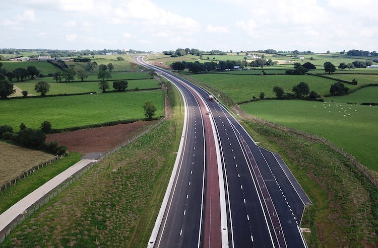
View east from Gallagh Road bridge of the
completed dual-carriageway, along with a swanky
new Type A layby on the right! One of the many
concrete accommodation lanes that have been
built is visible on the left. The embankments of
the new road are covered with literally
thousands of saplings – in ten years this scene
is going to look very different. [DFI image from
here]
View west from above Ballynafey Road overbridge,
plus the realigned Ranaghan Road on the left.
[DFI image from here]
View west of an extremely elegant accommodation
overbridge near Derryhollagh. The slender bridge
deck and interesting taper on the left give this
bridge a very gentle persona - well done to
whoever designed it. [DFI image from here]
23 Jul 2019: All eyes are now on the
Randalstown to Toome stretch of this scheme (the
other half being Toome to Castledawson) which is
due to open to traffic within the next few
weeks. Work on that stretch is currently focused
on the final touches of laying blacktop and
painting lines. Ahead of opening there are to be
two public events this Friday, 26 July, where
the public will be allowed to walk/run/cycle on
the new dual-carriageway! Alas I can't make it
due to work, but you can just turn up at the
Park-and-Ride at Drumderg Roundabout (eastern
end of the Toome Bypass). The 5 km Fun
Run/Walk will commence at 4pm, while the
10 km time trial cycling event will
start at 4.30pm. Proceeds will go to Moneynick
and Duneane Primary Schools, with a suggested
minimum donation of £5.
In other news, the digital aerial movies on the
contractor's YouTube are still the best way to
keep track of the project. This
one shows the Castledawson to Toome
stretch as it was last week. At the start of the
video, the future eastbound carriageway is
really taking shape (all traffic is using the
future westbound carriageway, which is already
complete). You can also see a nice, shiny new
concrete agricultural access road on the right.
At about 0:38 we cross Bellshill Road/Annaghmore
Road flyover junction where the sliproads are
taking shape, though more advanced on the south
(right hand) side. At 0:56 we pass over the new
footbridge at Brough Road, which is the point at
which the new road swings left onto an offline
route. We pass the Hillhead Road flyover
junction at 1:10, where foundations for the
bridge appear to be in place. After this, we can
see earthworks underway on the stretch
approaching the (entirely unnecessary -
opinion!) Deerpark Road flyover junction which
we pass at 1:40. The approach embankments to
this flyover look almost completed. The road
then goes onto a long, flat stretch close to
Lough Beg. Work here seems to be finally
underway in earnest, with what looks like
geotextile matting being laid 1:48 as a
foundation for the road. Two farm accommodation
bridges are also underway (1:57 and 2:10), and
the huge borrow pit that was dug here seems to
be being filled in again (1:57; being filled
with low-quality material from elsewhere on the
site). The embankments for The Creagh flyover
junction are completed with the bridge
foundations going in, at 2:18. Finally, work on
the new local road to carry Hillhead Road, Toome
parallel to the new dual-carriageway is evident
at 2:30 (the right-turn into Toome village will
be closed up). The most recent movie of the Toome
to Randalstown stretch is three weeks old,
but here
it is. See also the photos below.
Last month I got scolded by the contractor ;-)
for speculating that the road would open on 22
July. Not having learned my lesson, I am going
to do it again! The "tie-in" works referred to
at that time have been moved to the weekend of
Friday 2 August – Monday 5 August 2019, when the
A6 will be fully closed "to facilitate
tie-in works with the existing road network".
To me this, does sound like the work to divert
traffic onto the new dual-carriageway - perhaps
with just one lane each way initially. I may be
wrong, and neither DFI nor the contractor are
(probably wisely) not being drawn on the matter,
but that's my best forecast! EDIT
26 July – DFI today confirmed that they
intend to open the Randalstown to Toome
stretch on Monday 5 August.
Finally, the contractor Graham Farrans sent me
some lovely photos of the Toome to
Randalstown stretch four weeks ago which I never
got a chance to put up at the time, but I am
happy to share now. Thank you to them.
The eastern end of the scheme, this was the view
from the end of the M22 towards the new road on
18 June 2019, with the existing A6 Moneynick
Road heading off to the right. As you can see,
it won't take much more to et traffic onto this.
[Graham Farrans].
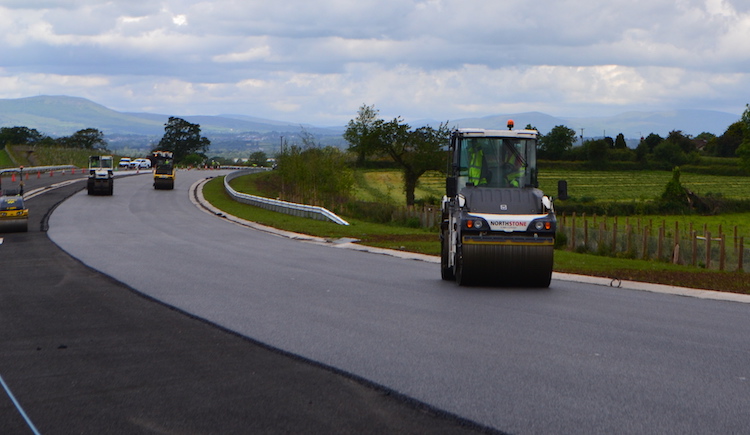
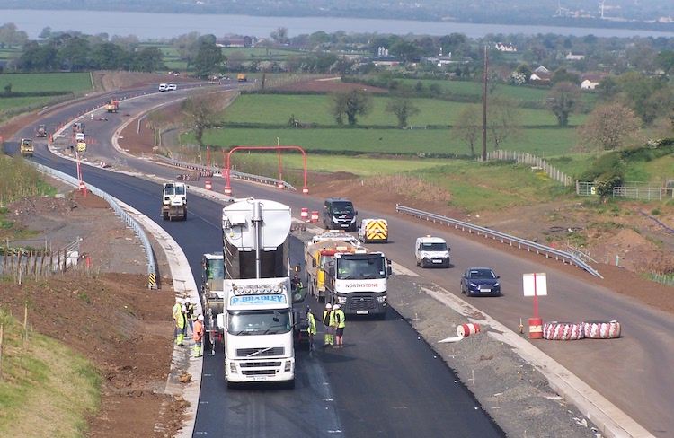
Blacktop being laid using a Northstone roller
near Ballynafey Road bridge on 18 Jun 2019. If
you are a civil engineering fan, this will be a
very satisfying image to look at! [Graham
Farrans].
Blacktop being laid on the new A6, as seen from
Ballynafey Road overbridge on 18 Jun 2019. There
are two drainage channels - one on the left, and
one in the central reservation, reflecting the
camber of the road on this gentle curve. Note
how the leftmost drain switches to the right
side as the curve changes direction ahead.
[Graham Farrans].
View of the largely-completed and enlarged
Drumderg Roundabout in Toome on 18 Jun 2019,
with the existing Toome Bypass behind the camera
to the right, and the new A6 dual-carriageway on
the left ahead. [Graham Farrans]. 26 Jun 2019: A quick update this time
for two reasons. Firstly, to share some
wonderful 360° drone photos taken of the scheme
by the amazing John Toner a couple of weeks ago.
He has put the images
here and created a map
here that shows their locations (note the
map link doesn't work on mobile devices).
Clicking on these will bring up a link to the
360° panoramas where you can hover over the new
road and have a grandstand view. Thank you to
John! Secondly, in my previous update below I
speculated that the new stretch of
dual-carriageway from Randalstown to Toome might
be going to open on 22 July. The contractor has
got in touch with me to say that, alas, that is
not the case! However, I do think that the
opening will probably take place sometime in
late July or early August. No date has yet been
announced so we shall have to wait and see.
13 Jun 2019: The scheme continues to
progress. This week there have been a series of
overnight closures on the west end of the Toome
Bypass to facilitate the relocation of water
pipes. The north end of Bellshill Road is also
due to (finally) reopen next week, coinciding
with the permanent closure of the north end of
Annaghmore Road and the opening of the new
Bellshill Northern Link Road which connects the
two together. The layout around here was one of
the biggest sticking points at the three (!)
public inquiries, so it's good to see it finally
built. Of more significance is the weekend
closure of the main A6 between Randalstown and
Toome from 10pm Friday 19 July - 6am Monday 22
July 2019. This is apparently to "facilitate
tie-in works with the existing road network".
To me this sounds suspiciously like the plan is
to open the new stretch of
dual-carriageway from Randalstown to Toome on 22
July. The timing fits with the progress on the
ground, the use of the term 'tie-in works' fits,
and the fact that during the following weeks the
temporary roundabouts are to be removed from the
Moneynick Road also makes sense. This is not
official information, so I could be wrong, but
it looks that way to me. Time will tell!
20 May 2019: The contractor is doing a
good job keeping their
site updated so rather than try to list
everything that has happened recently I am going
to highlight some key events and share some
photographs. Lots of people seem to be very
interested in this scheme, judging by the number
of emails and photos I get sent - I appreciate
them all, thank you, even if I can't share them
all here! Firstly, on the offline stretch
from Randalstown to Toome work is really now
counting down towards the opening scheduled for
the late summer (August?). Tarmac has already
been laid along much of the stretch and more is
going down every day. Work still to be done
includes the addition of the central safety
barrier and, where appropriate, side safety
barriers. See below for some photos taken at the
Ballynafey Road overbridge. The best way to get
an overall view is to look at this
computer-generated aerial movie from a
week ago. Thousands of trees have been planted
along the route, which will transform the road
over the next decade. Secondly the
offline stretch from Toome to Castledawson is
less advanced but still progressing well. This
movie begins near Hillhead Road, Castledawson
and goes east passing over the new Deerpark Road
bridge at 0:21. On the stretch near Lough Beg an
agricultural overbridge is taking shape at 0:40,
as well as a large borrow pit visible to the
right, which will probably be filled in again at
a later date. From here the video shows the
embankment for the new road that has been left
to settle for some months now, but work on a
second agricultural overbridge appears to be
underway at 0:54 before the video reaches the
Creagh junction at 1:03 where work on this
flyover is now clearly underway too. It is just
under two years until this stretch is due to
open, in early 2021. Finally, on the
online stretch along the Castledawson Bypass
work on the future westbound carriageway is
complete with work on the eastbound carriageway
now progressing well. The most
recent video of this stretch is now three
weeks old. A new footbridge at Brough Road is
now in place and last weekend two new
footbridges were craned into place over
Castledawson Roundabout. I include a number of
photographs below.
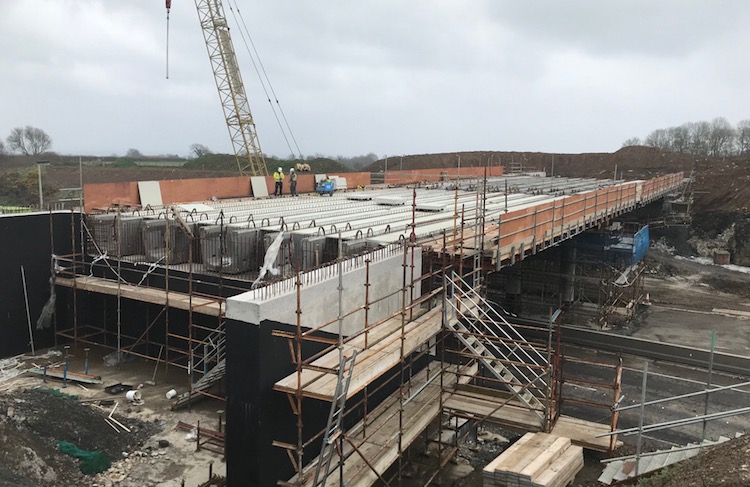
 Pic 1:
 The completed (and open)
Ballynafey Road bridge over the new A6 seen on
15 May 2019. [Wesley Johnston]
 Pic 2:
 Telephoto view west along the new
A6 from Ballynafey Road bridge on 15 May 2019,
showing tarmac being laid.The concrete channels
are for drainage, used instead of metal grilles
in the road surface. Some safety barrier is also
visible, in this case protecting drops into
culverts. [Wesley Johnston]
 Pic 3:
 View east from Ballynafey Road
bridge on 7 April 2019. Note the thousands of
new trees that have been planted on the
embankments. In ten years this will be like
driving through an avenue of trees. [Chris
Carter]
 Pic 4:
 Deerpark Road flyover continues to
make progress as seen on 4 April 2019. [Arthur
Ming]
 Pic 5:
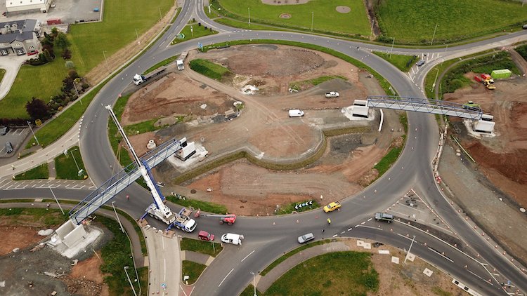
 Aerial view of Castledawson
Roundabout on 19 May 2019 after the two new
footbridges had been installed. The new A6 is to
the bottom right. [DFI image from Twitter]
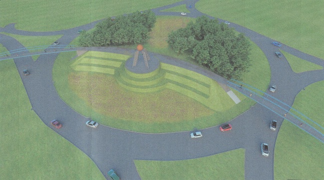 Pic 6:
 Artists' impression of how the
Castledawson roundabout will look after the new
footbridges have been completed and landscaped.
A piece of art will be installed as a
centrepiece.
24 Mar 2019: Another update, this time firstly
to draw attention to two aerial movies which
between them show the entire stretch between
Castledawson and Toome, including parts that
haven't been seen in aerial movies in a while.
This is the most challenging part of the scheme
as it runs through some very boggy ground with
several overbridges required. The first
movie begins at Castledawson Roundabout
where you can see progress on the two new
footbridges that are being built here. With all
traffic now using the future westbound
carriageway, the old A6 has been excavated and
the foundations of the future eastbound
carriageway are taking shape. You can see
interesting features including a layby and an
agricultural accommodation laneway at 0:21.
Bellshill Road flyover, well advanced but not
yet open, is seen at 0:45. Jumping then to the second movie at
the Moyola River Bridge we continue to the
rather convoluted temporary road network where
the future dual-carriageway diverges from the
existing A6 at 0:20. We reach the future
Hillhead Road junction at 0:45. The embankments
are completed, and are probably now being left
to settle for a few months before work begins on
the bridge. Between here and the Deerpark Road
junction at 1:30 is one of the least-developed
stretches, where progress is largely limited to
topsoil removal. This may well be one of the
last sections to be built. Deerpark Road
junction itself is progressing well with the
bridge in place, but no sight as yet of the
embankments on either side. The next stretch,
from 1:40 to is the environmentally-limited
section that runs close to Lough Beg. The
whooper swan overwintering period is finally
over so work has now resumed on this stretch,
which includes topsoil stripping, a culvert at
1:50 and an accommodation overbridge at 2:10.
The stretch from here to The Creagh junction
appears to have been built up with an
embankment. I'm not sure whether this is the
actual road embankment, or whether it's a
surcharge designed to compact and settle the
ground below. The video reaches The Creagh
junction at 2:40. This is similar to Hillhead
Road junction, in that the embankments are
completed, and are probably being left to
settle. The future road re-joins the A6 near
Toome at 3:00. The current right-turn into Toome
on the Belfast-bound carriageway is being closed
as part of the project, and the Hillhead Road is
being diverted onto a new local road that you
can see being built to the right of the main
road at 3:10. A very interesting video.
Secondly, the contractor has put up a
new update on
their web site here which contains more
details. I am not going to repet everything from
there on this site, but it contains pictures and
a movie of the Deerpark Road beam lift as well
as ground-level photos of the offline section
between Randalstown and Toome which is now due
to open in "mid/late summer 2019". If the borrow
pits are your thing – and let's face it, they're
fascinating wee blighters! – there's also
details of what's happening to those. There are
some excellent photos in this update, so please
pop over and have a look. We are now almost at
the half way point of this four-year with scheme
with almost two years under the belt and two
more to go until the whole road is open to
traffic.
6 Mar 2019: We are now on the countdown
to the opening of the first part of this scheme,
namely the offline stretch from the end of the
M22 at Randalstown to Toome which is currently
scheduled to open during the second half of
July, ie just over four months from now.
Exciting times! Work on the Randalstown West
junction – where the M22 will join the new
dual-carriageway – is progressing well, as can
be seen in this
aerial movie taken on Monday. Meanwhile,
Arthur Ming has shared more photos of the
Deerpark Road junction with its beams now in
place, two of which I reproduce below - thank
you Arthur. Work is now getting underway on the
approach embankments for this bridge, as can be
seen in this
aerial movie, also taken on Monday.
 Deerpark Road bridge sporting its ten
brand new beams on 23 Feb 2019. [Arthur Ming] Deerpark Road bridge sporting its ten
brand new beams on 23 Feb 2019. [Arthur Ming]
Closeup of the central pillars of the Deerpark
Road flyover, with five beams resting on it from
the left, and five from the right. The structure
bolted to the nearest beam is to faciliate
construction workers and will eventually be
removed. 23 Feb 2019. [Arthur Ming]
10 Feb 2019: A quick update to share two
photos that were taken on 7 February by Arthur
Ming, showing the work at Deerpark Road (on the
offline stretch between Castledawson and Toome).
Both views are looking west from the current
Deerpark Road towards the two bridge abutments
and one set of central pillars that will
eventually carry the realigned Deerpark Road
over the future dual-carriageway. The beams for
this bridge are due to be lifted into place on
16/17 February, after which the bridge deck will
be built. After that, presumably, work will take
place to divert Deerpark Road over it to allow
completion of the new road below. Thanks Arthur!
View west from Deerpark Road on 7 February 2019
showing work on the flyover that will eventually
carry Deerpark Road over the new
dual-carriageway. This
is the same view before work began. [Arthur
Ming]
Closeup of the northern bridge abutment at
Deerpark Road taking shape. The beams are due to
be lifted into place here on 16/17 February.
[Arthur Ming]
6 Feb 2019: The contractor has put up a
new video, dated yesterday, of the stretch from
Toome to Randalstown, visible
on YouTube. It shows this stretch very
advanced, with tarmac in place now on long
stretches, including much of the eastbound
carriageway and now sizeable stretches of the
westbound carriageway too. Most of the drainage
also seems to be in place too, and hundreds of
saplings appear to have been planted along
embankments on the stretch too. Parts of the
site are already starting to green over. Towards
the end of the video you can see that the borrow
pit at the Randalstown West junction is now
being filled in. The borrow pit was used to
extract high quality rock for construction, and
is now being replaced with low quality earth.
The aim is to achieve a cut/fill balance,
minimising the amount of material that has to be
disposed of off-site. We are anticipating the
opening of this section by the summer. The
contractor has also updated their own
web site. I won't repeat everything here,
but highlights include the beam lift at Deerpark
Road (between Toome and Randalstown), now
scheduled for the weeked of 16/17 February. You
can see the three sets of supports in place in this
video. Drumderg Roundabout is also to be
realigned (for the umpteenth time) this coming
weekend. Bellshill Road south of the new
dual-carriageway is currently closed, and will
remain so until late March. This will be
followed by a full closure of Bellshill Road
north of the new road from 25 February until
early May. This is to allow the contractor to
reconnect the local roads to the new
grade-separated junction that's being built
here.
16 Jan 2019: Work is now underway once
again after the Christmas break, and there have
been more developments. As per usual, this
information is partly sourced from the
contractor's own
web site and partly from YouTube videos
which I shall link to. Starting at the western
end, Castledawson roundabout is currently down to
one lane to faciliate the construction of two
footbridges that will allow easier pedestrian
access over this busy junction. On the
Castledawson Bypass, all traffic has been using
the future westbound carriageway for about six
weeks and stretches of the old A6 have now been
excavated for reconstruction, as seen in this
YouTube video posted last week. The video
shows lots of earthworks especially around
Hillhead Road (visible at 1:10). Just prior to
Hillhead Road (visible at 1:02) you can see how
the existing A6 has been moved onto the route of
the future dual-carriageway which curves off to
the north (left) at this location. In Castledawson
itself, the new link road that connects Annaghmore
and Bellshill Roads is well advanced and traffic
is due to be diverted onto it in late February.
The video ends at the site of the future Deerpark
Road junction (1:40) where the bridge beams are
due to be lifted into place on 9/10 February. At
Toome, the contractor intends to carry out
"realignment" at Drumderg Roundabout on the
weekend of 25-28 January. This *might* mean
switching A6 traffic onto the new S-shaped section
of road that will link the current A6 to the
roundabout after the dual-carriageway opens. You
can see the section of road I mean in this
YouTube video (on the left at 00:02). It
might also mean altering the layout of Drumderg
roundabout. This video extends along the full
length of the offline stretch to Randalstown. You
can see that tarmac has now been laid on the
future eastbound carriageway on about 75% of the
route. The Toome-Randalstown stretch is due to
open to traffic in "mid 2019" so not long to wait
now. It will probably open with one lane each way
initially, and then open fully in due course. The
video ends at the new junction at Randalstown (at
2:57) where you can see the road that loops over
the bridge to connect to the westbound carriageway
taking shape.
3 Dec 2018: A major milestone was
reached today with traffic using part of the new
A6 for the first time this morning. Traffic
travelling on the Castledawson Bypass
for the 2.2km between the Moyola river bridge
and Castledawson roundabout were switched onto
the future westbound carriageway - as tweeted
by DFI's permanent secretary earlier - and
Bellshill Road was also reopened. Work will now
begin on building the eastbound carriageway on
the site of the old road (I say "old", but it
was actually itself only opened in 1992!).
Well done to the contractor for reaching this
point. The contractor has put up an update with
photos on
their web site here - what follows is a
few key points pulled out of that. Closer to
Toome, work on the Deerpark Road grade-separated
junction continues to progress with piling,
bases and column works now complete. Work is
currently focused on the bridge abutments are
the beams are due to be lifted into place during
January. Work is now also underway for the new
pair of footbridges that are being added to
Castledawson Roundabout. All of the above can be
seen in this
aerial movie, posted last week before the
carriageway switchover, starting at Castledawson
Roundabout and moving east along the
Castledawson Bypass. Meanwhile, on the offline
stretch between Toome and Randalstown
work progresses steadily. The deck is due to be
poured on what the contractor is calling
"Pearsons Accommodation Bridge", though I'm not
aware of any maps in the public domain that
would allow us to identify where that bridge
actually is, since Pearson is probably the name
of the landowner. Two aerial movies of this
stretch of the scheme were put online a week
ago. This
one shows the western 2km, starting at
Toome and working east with the road foundation
largely in place and drainage works evident.
Towards the end you can see a future layby on
the westbound carriagewway. This
movie shows the easternmost 1.3 km of the
same stretch, ending at the M22 at Randalstown.
At the end of the movie you can see the "loop"
that will allow westbound access to and from the
new road taking shape.
11 Nov 2018: The dark evenings have
really set in now, but work continues on this
scheme which has now been underway for 18 months
with just over two years to go until completion.
Taking the scheme in three sections: At the
western end of the scheme, work on the upgraded
Castledawson Bypass (from the
Castledawson roundabout to Hillhead Road) is
very advanced, with the future westbound
carriageway close to completion. All traffic
will be switched from the current A6 to this new
carriageway on the weekend of 30 November, so
that the current road can be reconstructed to
become the future eastbound carriageway.
Progress is best seen via this
computer-generated flythrough dating from
four days ago which begins at Castledawson
roundabout and works its way east. There is only
one grade-separated junction on the Castledawson
Bypass - at Bellshill Road/Annaghmore Road (at
0:38 in the video) and Bellshill Road is
currently closed to facilitate its realignment
to the the new link road that is being built as
part of the junction. On the offline stretch
between Hillhead Road and Toome progress
varies. The first stretch, from Hillhead Road to
to Deerpark Road, starts at 0:56 in the video
and you can see that earthworks are underway on
both grade-separated junctions, but not much
work evident on the stretch between them. The
next stretch, past Lough Beg and on to The
Creagh (not shown in the video) has seen
relatively little progress and in any case work
here has been paused until the spring due to
environmental restrictions. The final stretch,
the long offline section from Toome to
Randalstown, is looking very advanced
indeed with both carriageways constructed and
tarmac being laid on a long stretch in the
middle of the section. This
computer-generated flythrough shows
progress at the Castledawson end two weeks ago,
while this
video shows progress at the Randalstown
end. The pictures below were taken from
Ballynafey Road bridge by Chris Carter about
three weeks ago (apologies to Chris that I have
only shared it today). It illustrates how well
advanced this section was in late October. We
are now only 8 or 9 months away from the opening
of the Toome to Randalstown stretch (next
summer) so that will be a very exciting time for
travellers!
View east (towards
Randalstown) along the future A6
dual-carriageway from the Ballynafey Road
overbridge on 18 October 2018. [Chris Carter]
Same location as previous photograph, but
looking west (towards Toome) showing work
underway. The HGV on the extreme right is on the
current road, the A6 Moneynick Road. 18 October
2018. [Chris Carter] 6 Oct 2018: The project continues to
advance, with the opening of the new
park-and-ride at Drumderg roundabout in
Toome, and the accompanying footbridge, on 24
September as anticipated. The contractor has
lost no time in ripping out the old
park-and-ride, the site of which is needed for
the enlarged roundabout. The enormous cutting at
the end of the M22 is now essentially complete,
so motorists can now see along the route that
the future dual-carriageway will take from
Randalstown (see photo 1 below). Progress on
this stretch, which is almost entirely offline,
can be seen in this
computer-generated flythrough of the 1500
metres at the eastern end of the project. On the
other side of Toome the offline stretch that
passes close to Lough Beg, via Deerpark Road, is
also advancing with substantial earthworks
completed and the approach embankments for the
Creagh junction and flyover now in place, as
seen in this
video. The same is the case further
west where the new road rejoins the
existing A6 near Castledawson, with the
embankments for the Hillhead Road junction -
though not the bridge structure - also in place.
The Castledawson Bypass itself is the only
stretch where the road is an online upgrade, and
here work on the future westbound carriageway
has advanced to the point that the final surface
is being laid on the western part (photo 2
below). An aerial video of the Castledawson
Bypass can be seen
here, showing the progress on the future
westbound carriageway. It will not be too long
before traffic is transferred onto the new
carriageway to allow the construction of the
future eastbound carriageway. We are now less
than a year away from the planned opening of the
Randalstown to Toome stretch, though the more
challenging Toome to Castledawson stretch is
still about two and a half years away.
 Photo 1: View west along the route of
the future dual-carriageway from the end of the
M22 at Randalstown on 27 Sep 2018. The current
Moneynick Road is seen curving to the right.
Until a few months ago there was a huge hill
just ahead which has now been cut away (same
view before work began) [Wesley Johnston].
Photo 2: Tarmac in place on the future
westbound carriageway of the A6 Castledawson
Bypass on 27 Sep 2018. All traffic is likely to
be soon switched onto it to allow work on the
eastbound carriageway. [Wesley Johnston]
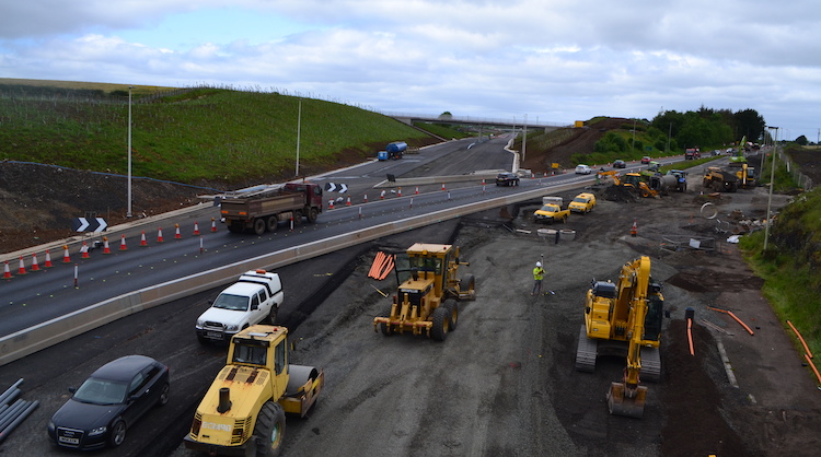
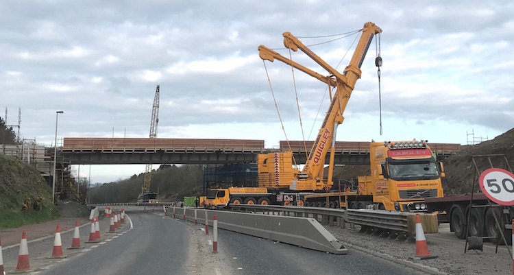
12 Aug 2018: The project progressed well
during July. You can read the contractor’s
latest update on their
web site here. As before, I’m not going to
repeat everything here so I encourage you to
click that link to get a feel for what’s been
happening and what will be happening in the
coming weeks. The two most notable dates are the
opening of the new link road at Randalstown West
(end of the M22) which connects the
dual-carriageway to the new flyover. It is due
to open on 3 September. The relocated
park-and-ride facility at Drumderg Roundabout in
Toome is then due to open in “mid” September.
One of the most obvious recent changes has been
that the bank at the end of the M22 at
Randalstown has finally been cut through, so
drivers can now see right along the route of the
future dual-carriageway as they join the
existing Moneynick Road.
The amazing John Toner took a series of 360°
panoramas at various sites along the new road on
25 July. (Although he sent them to me the
following day I was busy attending the birth of
NIRoads Junior #3 at the time and hence am only
updating the site today!) He then took more at
the end of the month. You can see them all by
clicking this
link. John has also created an interactive
map that shows the location of each 3D panorama,
available here.
Thank you John - these pictures are amazing and
give a real flavour for how things are
progressing.
21 Jul 2018: A number of things to
report. Firstly, construction on the scheme has
now passed its first anniversary, which means
that the eastern half (Randalstown to Toome is
now over 50% complete) and we are now only a
year from opening in "mid 2019". To celebrate,
the contractor has put up an excellent first
anniversary page that contains a summary of work
to date, videos and an audio clip. There is no
point in me trying to repeat it all here, so I
suggest you pop
over to the page and have a read! In terms
of visible works, the beams for another bridge
were craned into place last week - this was an
accommodation bridge (a bridge that preserves
access to private property) at "Dobbin's lane".
The bridge consists of two spans (one per
carriageway), each of which consists of two 66
tonne precast beams 29 metres long. Three of the
photos below are of this lift, taken from a DFI
tweet. In addition, the first overbridge
to be opened to the public came
into use on Monday 16 July - this was the
Ballynafey Road bridge, which carries a local
road over the new dual-carriageway between
Randalstown and Toome. The scheme continues to
make use of six huge "borrow pits", five of
which are in use and the sixth (near Deerpark
Road between Castledawson and Toome) is to come
into operation by the end of the month. The
contractor tries to keep a cut-fill balance, ie
material excavated from one part of the site is
used on other parts of the site so that very
little material has to be disposed of off site.
However the issue is that the material is not
all of the same quality, ie not all of it is
suitable for use in construction. Borrow pits
allow good quality material to be excavated for
the fills, and then poorer quality material from
cuttings is put back into the borrow pits. When
the scheme is completed the topsoil is restored
and it looks as if the pit was never there
(hence "borrow" pit). The last picture below was
sent by a site visitor who prefers to remain
anonymous - thank you - and shows the borrow pit
near Bellshill Road. It's hard to get a sense of
scale, but the pit looks to be around 30 metres
deep, and that is a mature tree above. The
contractor will certainly have benefitted from
the fanstastic weather over the past two months.
Major earthworks on part of the stretch between
Toome and Deerpark Road will have to pause come
October due to the presence of overwintering
swans, but the contractor appears to have made
good progress on this stretch. A reminder that
the contractor puts up regular aerial videos here.
If they seem obsessed with borrow pits it's
because the videos (sadly!) aren't there for the
benefit of infrastructure enthusiasts, but to
allow the engineers to monitor the movement of
material around the site.
Crane lifts one of four beams into place for the
"Dobbin's lane" accommodation overbridge c20
July 2018. [DFI image from here]
Crane lifts one of four beams into place for the
"Dobbin's lane" accommodation overbridge c20
July 2018. [DFI image from here]
View along the new A6 between Randalstown and
Toome showing the carriageway foundation in
place. The metal poles with yellow dots on top
that run along the central reservation are used
by computerised systems in the vehicles to check
the level of the layers of material that are
being laid to form the road surface. [DFI image
from here]
The huge borrow pit at Bellshill Road seen in
early July 2018. [Anonymous site contributor]
24 Jun 2018: The contractor (Graham
& Farrans) and the Institution of Civil
Engineers jointly held an open day on the site
yesterday. Visitors were treated to a
presentation about the scheme, a demo of a 3D VR
headset that civil engineers use, and then a
hard-hat visit to the Bellshill Road flyover
construction site on the Castledawson Bypass. So
thank you very much to them. I've included some
shots below. The scheme is progressing on
schedule. The eastern part of the scheme
(Randalstown to Toome) should open to traffic
just over a year from now, in "late summer
2019". On the Castledawson Bypass, which is
being widened, the westbound carriageway is
under construction and it's likely that all
traffic will be switched onto it later in the
summer to allow the current road to be
reconstructed to form the new eastbound
carriageway. Opening of the western part of the
scheme (Toome to Castledawson), which has more
challenges (softer land, more environmental
restrictions, being partly online) will come
either at the end of 2020 or the start of 2021.
You can see a computer-generated
aerial movie of the stretch as it was last
week. The contractor is putting these movies up
every couple of weeks, which is great, though
they are mainly done to allow them to track the
movement of fill material around the site.
Pic 1: Future westbound carriageway of the A6
approaching Bellshill Road on 24 June 2018. The
ground here was dug down to 2 metres below the
adjacent ground level and then filled up to
about 2 metres above that level. The gravel on
the right is the subsurface of the future road.
[Wesley Johnston].
Pic 2: Earth embankment that will carry the
east-facing sliproads from the Bellshill Road
flyover onto the A6 on 24 June 2018. The current
A6 Castledawson Bypass is just ahead. The
photographer is standing on what will be the
central reservation. [Wesley Johnston].
Pic 3: Members of the public at the ICE open day
walking towards Bellshill Road flyover on their
gudied tour on 24 June 2018, on what will be the
future westbound carriageway. [Wesley Johnston].
Pic 4: Underneath of the Bellshill Road flyover
on 24 June 2018. The bridge consists of two
abutments, four central columns (shown here) and
eight beams. Once the beams are put in place
plastic formwork sheets are inserted between
them (visible here) and the concrete deck poured
on top. The road is then constructed directly on
the deck. [Wesley Johnston].
Pic 5: Newly completed parapet on Bellshill Road
bridge on 24 June 2018. The red "formwork" that
can be seen on the left previously ran right
across the bridge and was used to case the
concrete. Now that the parapet has been
completed, the formwork can be removed. The
bridge is not yet open as the approach
embankments are still under construciton.
[Wesley Johnston].
Pic 6: View east towards te Moyola Road bridge
on 24 June 2018. The section ahead will carry
the future westbound carriagway. Due to
increased environmental standards, this bridge
gives over a metre greater clearance over the
river than the 1990 bridge to the left of it.
[Wesley Johnston].
13 May 2018: Construction of this scheme
has just passed its first anniversary, and there
is now just a year or so to go until the stretch
from Randalstown to Toome opens
to traffic (officially due to open "during
2019"). There will be few travellers who will
miss the Moneynick Road that it will replace!
Work on this stretch continues to advance well,
and this is best seen via this
computer-generated aerial movie of the
stretch as it was last week. The movie begins at
the Drumderg roundabout at Toome, and you can
see the new footbridge now in place at 00:06, as
well as the new park-and-ride facility underway.
The existing park-and-ride car park, on the
opposite side of the roundabout, will be removed
to make way for the enlarged roundabout and
connection to the new dual-carriageway. (I will
resist the temptation to discuss yet again what
a shame it is that this roundabout is to
remain!) The flight then goes along the offline
route of the new dual-carriageway showing (for
example) the new Ballynafey Road overbridge with
beams in place at 1:27, box culverts at 1:39 and
1:46, a significant cutting at 1:52, foundations
for an agrticultural accommodation overbridge
going in at 2:10, gravel foundations being put
in place between 2:20 and 2:35, the new
Derrygowan Road overbridge in place (minus its
approach ramps) at 2:35, the cutting to approach
the existing M22 (which has still not been cut
through the final stretch) at 3:07, and finally
the Randalstown West bridge in place at 3:12.
Work is also underway on the Castledawson to
Toome stretch. This is best seen in the
first two photographs below (kindly sent by
Damien Devlin of Jupe a
couple of weeks ago but which I have only just
got a chance to put up) and also in this
computer-generated aerial movie of the
stretch as it was on Friday. The notes on the
video advise that due to windy conditions some
sections are missing. The video begins at
Castledawson Roundabout, which has had trees
felled to make way for a planned new footbridge
structure. Continuing along the existing
Castledawson Bypass you can see that the
embankment for the widened road is almost
complete with gravel foundations in place on a
long stretch. The new Bellshill Road/Annaghmore
Road flyover is visible at 0:37. This bridge
also requires construction of a new local road
which, if you are interested, is covered
separately in this
movie. Bellshill Road flyover has now had
its deck completed and the temporary formwork
was removed yesterday. The widened bridge over
the Moyola river is visible at 0:48, with its
deck under construction. The visuals reappear at
01:00, which is the point at which the stretch
where work was paused during a legal challenge
begins. Significant process can be seen since
work began in March, including a new temporary
road to carry Hillhead Road traffic around the
construction site of a future overbridge at
1:19. No earthworks appear to have yet begun
between here and Deerpark Road, visible at 1:56,
but after this major earthworks now appear to be
underway along the stretch that runs parallel to
Lough Beg. At 2:35 the view reaches the site of
the future Creagh grade-separated junction, with
the loop for the eastbound sliproads visible on
the left but no sign yet of the future flyover.
This junction will be linked by a short stretch
of new road to the existing Creagh roundabout.
Finally, at 2:46, the view reaches the existing
Toome Bypass where the stretch terminates. The
photographs below show some of the same things
but higher-resolution. My thanks to Shay
Sweetnam and Damien Devlin of Jupe for
sending me these images to share. Excellent work
by all involved in the scheme. A reminder once
again that the contractor is maintaining
a very useful web site that gives advance
notice of the dates of planned closures as well
as progress notes and photographs of their
own.
View east along the A6 Castledawson Bypass on 29
April 2018 showing the foundation for the future
westbound carriageway now in place, with all
traffic using the existing road which will be
reconstructed later to become the eastbound
carriageway [Damien Devlin].
View, looking north-east, of the new Bellshill
Road grade-separated junction with bridge deck
and approach embankments both in place. The
route of the future eastbound sliproads is
easily discerned in the shape of the curved
embankment above the bridge. [Damien Devlin]
View of Drumderg roundabout, Toome, on 29 April
2018 looking south-east, showing the footbridge
now in place over the start of the existing
Toome Bypass (though minus its ramps and steps),
the new park-and-ride on the left, the route of
the future dual-carriageway to Randalstown at
the top of the shot, and the route of the
realigned Moneynick Road (which will revert to
being a local road) taking shape above the new
car park. The existing Drumderg roundabout has
shrunk to the size of a postage stamp, but it
will return in more glory than ever, expanding
beyond its original size to cover most of the
existing park-and-ride facility seen just above
the current roundabout. [Damien Devlin]
Ground-level shot of the new Drumderg footbridge
in place on 28 April 2018, taken from the
existing park-and-ride facility. [Shay Sweetnam]
21 Apr 2018: From the point of view of
the travelling public, considerable change has
been evident in the past two weeks. Firstly, the
bridge beams for the Randalstown West
grade-separated junction (Artresnahan, at the
end of the M22 motorway) were lifted into place
during a weekend closure on 13-15 April. The
bridge consists of two spans, the central
pillars of which occupy what was the westbound
carriageway of the M22, hence why the M22
reduces to one lane each way further back. Each
span consists of five 30 metre beams, each
weighing 60 tonnes, meaning a total of ten beams
were lifted over the weekend. The pictures below
were taken from a DFI tweet
and show the beams in place. Great work by the
contractor. A further 15 bridge beams for the
widened bridge over the Moyola River near
Castledawson were also lifted into place over
the past week. Tomorrow (Sunday) will see the
installation of the deck of the new footbridge
over the Toome Bypass at Drumderg roundabout,
which is to provide pedestrian access to the
relocated park-and-ride site. The concrete
bridge pillars are already in situ, but the deck
itself is a steel arch structure which is
already on site, ready to be placed atop the
pillars. The pictures below of this bridge are
taken from another DFI tweet.
The other obvious change for the public is the
creation of a new roundabout at Derryhollagh
Road between Toome and Randalstown. This may be
a nuisance, but is required to facilitate the
safe access to the side road for construction
vehicles on this very busy, bendy road. The
roundabout will be removed at a later date.
Finally, a reminder that you can get up-to-date
information on the works at the contractor's own
web site.
Pic 1: View of the Randalstown West overbridge a
few weeks ago showing the pillars under
construction in what was the westbound
carriageway of the M22. View is looking east.
[DFI from here]
Pic 2: Similar view to picture 1 on 16 April
2018, showing the ten bridge beams in place at
Randalstown West, along with associated
falsework on either side to facilitate
construction workers. [DFI from here]
Pic 3: A heavy-duty crane finishing up at
Randaltown West on 16 April 2018. In total the
ten bridge beams that have been installed weigh
600 tonnes and will have taken the same number
of specialist lorries to bring them to the site.
[DFI from here]
Pic 4: View looking south across the Randalstown
West overbridge with the bridge beams in place.
The concrete walls closest to the camera are the
wing walls of the bridge abutment, with the
black material being a waterproofing layer on
the section that will be below ground level when
the bridge is completed. The people give the
scale of this impressive structure. [DFI from here]
Pic 5: One of the spans of the Drumderg
footbridge sitting beside the A6 last week ready
to be craned into position on 22 April. The man
on the left is standing on the pillar for the
main span, with the smaller cylindrical pillars
being for the approach ramp. [DFI from here]
Pic 6: A smaller prefabricated bridge section
waiting beside the pillar that will support it
once it carries pedestrians over the A6 Toome
Bypass, visible beyond. [DFI from here]
3 Apr 2018: The past fortnight has seen
another milestone on the construction of this
new road, and that is the commencement of work
on the stretch from The Creagh to Hillhead Road.
Work on this stretch had been delayed initially
by an unsuccessful legal challenge, and then by
the environmental requirement not to carry out
major works in this area during the swan
overwintering season. However this restriction
ended in mid March and work has now commenced on
the stretch - a milestone as it means that work
is finally underway on all parts of the scheme.
Matthew Cole took some photos of these
earthworks advancing away from The Creagh four
days ago and posted
them here on Twitter. An aerial YouTube
video of the same area uploaded on 29 March can
be viewed here.
Work has now been underway for ten months and
progress continues to be excellent. About a
fortnight ago the beams for the Ballynafey Road
overbridge were craned into position. This is
reported on the contractor's own
web site, which is being regularly updated
with lots of interesting information and photos
and is well worth bookmarking. According to that
web site, the bridge beams for the Randalstown
West overbridge (at the end of the M22) are
scheduled to be lifted into place between 13 and
16 April, requiring a weekend closure of the A6
here. Two other lifts planned in the near future
are the beams for the widened bridge over the
River Moyola (11-13 April) and the installation
of the footbridge that is currently under
construction at the start of the Toome Bypass at
Drumderg roundabout.
13 Mar 2018: Last weekend saw a great
deal of excitement on the scheme with a major
beam lift taking place at Bellshill Road on the
Castedawson Bypass. The flyover requires 8
reinforced concrete beams, 4 each on two spans,
that will carry Bellshill Road over the new
dual-carriageway. The beams are so large that
they require a lorry each and they were seen
parked up at the end of the M22 near Randalstown
the week prior to the lift. The A6 at
Castledawson was closed over the weekend and the
beams were carried along the Moneynick Road via
Toome (spotted
by one eagle-eyed infrastructure fan) on Friday
night. The lift itself seems to have had perfect
weather and all eight beams were firmly in place
by the time the road reopened. Several more
infrastructure fans photographed the
lift and the outcome.
The pictures below are DFI photos and show the
result. For safety and efficiency the four
outermost beams had their falsework (temporary
construction platforms) already bolted on prior
to the lift. Thank you to all the people who
tweeted updates and sent me photos - it is great
to see how many people out there are interested
in this project. Well done to the contractor.
Crane lifting one of the beams
for Bellshill Road into place c10 Mar 2018. This
beam has the temporary falsework already bolted
on ready for construction of the deck above.
[DFI photograph taken from this
tweet]
View of the four beams making up one of the two
spans of the Bellshill Road flyover following
the beam lift, c10 Mar 2018. Work will now focus
on completing the deck above. [DFI photograph
taken from this
tweet]
The job completed - eight beams successfully in
place at Bellshill Road, c10 Mar 2018. The
current A6 Castledawson Bypass is in the
foreground, which is to be upgraded to full
dual-carriageway with one carriageway passing
under each span. [DFI photograph taken from this
tweet] 20 Feb 2018: Work continues well on both
halves of the scheme. On the entirely offline Randalstown
to Toome stretch work has been focused on
building culverts for the numerous watercourses
on the stretch, and creating large cuttings and
embankments to allow the road to traverse the
hilly terrain. This
computer-generated aerial video, put up by
the contractor on 19 Feb, shows a typical 1.5 km
stretch of the new road showing all these
features. The road is designed to have a
cut/fill balance, ie material cut from one place
is used as fill elsewhere. However it often
happens that the fill is needed before the cuts
are done, or that the fill needs to be of a
different type than the material sourced from
the cuts. This problem is resolved by taking
rock out of a "borrow pit", which is later
filled in again with fill. Borrow pit "K",
located close to Moneynick Primary School, has
seen explosives used to blast out the rock. You
can see a video of a blast (from last December)
here
with the blast happening at 00:17, and an aerial
video of how borrow pit K looked this week here.
Blasting in another borrow pit is close to the
current A6 meaning the road has to be shut for
30 minutes during blasting. At the tie-in to the
end of the M22 at Randalstown, construction of
the future flyover is underway, with all traffic
shifted over to one side to make space for the
work. At the Toome end, work to enlarge the 14
year old Drumderg roundabout is also well
underway. This
aerial movie shows the current state of
works with the curved road at the top left of
the video (at the very start) being the new bit
of road that will allow the existing Moneynick
Road to be accessed once the dual-carriageway
opens. A footbridge is also being built over the
start of the existing Toome Bypass in order to
provide access to the new park-and-ride facility
which will be sited on the far side of the
roundabout. On the partly online Toome to
Castledawson stretch, intense work is
taking place to widen the existing Castledawon
Bypass (itself
opened in 1992). This involves two major
bridges - a flyover at Bellshill Road, and
widening the bridge over the Moyola River.
Because the route on this stretch is literally
on top of the existing road, we are currently
experiencing a series of unavoidable weekend
closures that began on 26 January and will
disrupt Belfast-Derry traffic until at least mid
March. This
aerial video begins at the Moyola Bridge
and then heads east, and shows progress as of
last week. You can see the proximity of the
works to the existing road. At 00:15 in the
video you can see the route of the new
dual-carriageway heading offline to the left.
This is the start of the offline stretch that
passes near Lough Beg. Work on this stretch is
currently paused due to overwintering swans, but
is due to commence within the next couple of
months. Work has now been underway on the
project for 9 months. With thanks to David
Chambers for a correction to the borrow pit
identifications.
7 Jan 2018: December saw low
temperatures and a lot of snow, but it didn't
stop the contractors (Graham Farrans Joint
Venture) who installed the first bridge beams on
the scheme in the middle of the month. The beams
were for an overbridge that will carry
Derrygowan Road over the new dual-carriageway
between Toome and Randalstown. The photos below
were taken from the Department for
Infrastructure's Twitter
feed. They show how the bridge consists of
two abutments, plus a set of central columns in
what will be the central reservation, creating
two spans. The precast concrete beams were put
in place over the course of two days, five for
each span. The scale of these beams is enormous
- the first photo shows that they are so large
and heavy that they require a lorry each! The
contractor has put up an article on the lift on
their new dedicated web site here.
The new web site for the scheme can be accessed
at www.a6rcdualling.co.uk
which contains updates and photos and well worth
checking out. It is also worth watching two
movies on YouTube which are computer-enhanced
flythroughs of the scheme as it looked in mid
December. The first movie, here,
starts at Castledawson Roundabout and travels
4km east to near Toome. Beyond this, in the
vicinity of Toome, there is currently a
moratorium on major earthworks taking place due
to overwintering swans, but this will cease to
be a restriction in March at which point
earthworks can commence here too. The second
movie begins at Drumderg roundabout east of
Toome (note the new footbridge over the Toome
Bypass being built at 00:04) and goes 7km east,
all the way to Randalstown. Derrygowan Road
bridge appears at 02:12, though the video was
made before the beams were in place. At the end
of the scheme, you can see the foundations of
the bridge at the future grade separated
junction at the end of the M22 at 02:48. Work
has now been underway for seven months, with
three years to go until completion of the whole
project.
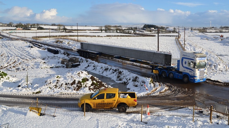
A single precast reinforced
concrete beam arrives by lorry at Derrygowan
Road in mid December 2017. [DFI from here]
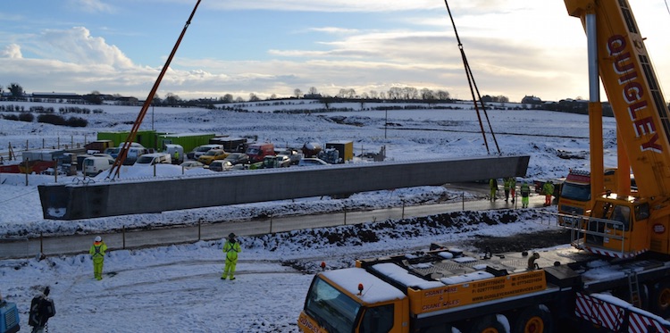
After being unloaded, a 500 tonne crane lifts
the beam ready to swing it over to its new home
over the future dual-carriageway near Derrygowan
Road in mid December 2017. [DFI from here]
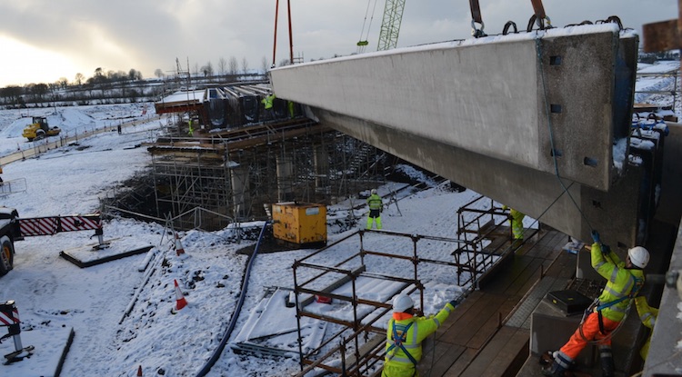
Graham Farrans Joint Venture engineers place the
beam in its place, in this case forming part of
the northern bridge span. Derrygowan Road
currently runs on the left, but will be rerouted
over this bridge once it's finished, and the new
A6 will run underneath. Taken in mid December
2017. [DFI from here]
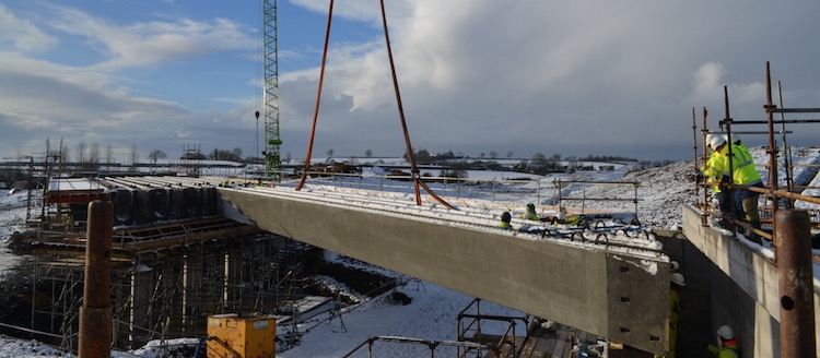
The beam in place, forming the second of five
beams that will make up the northern span of the
Derrygowan Road overbridge. The five beams for
the southern span are already in place ahead.
Taken in mid December 2017. Note the cutting
heading off into the right distance, which will
be the route of the new dual-carriageway. [DFI
from here]
30 Nov 2017: A very quick update to
share another aerial movie which has been posted
on YouTube by JUPE,
showing progress on the Castledawson Bypass
around a month ago (apologies for the delay in
posting this). At time index 0:55 you an see a
good top view of the new Bellshill
Road/Annaghmore Road grade separated junction
with the foundations of the bridge piers now in
place. On the rest of the scheme work seems to
be progressing well, though delays on the
westbound M22 at Randalstown due to the
roadworks continue to cause considerable delays
and consternation on social media.
14 Oct 2017: The scheme has now been
underway for about 5 months, and there has been
a lot of progress at some points. I have 6
photos to share this time, the first 3 of which
are with thanks to the contractor Graham/Farrans
and the second 3 of which are with thanks to
John Toner, who took aerial photos from a drone.
The first three pictures below were taken on the
Randalstown-Toome stretch where work to date
seems to be focused on major earthworks, in
particular a very large excavation. I am not
100% sure whether this is a cutting or the road
itself, or whether it is some kidn of 'borrow
pit', but either way it looks to be at least 20
metres deep. The second set of images show works
on the Castledawson Bypass at the western end of
the scheme. This road only dates back to the mid
1990s but is being upgraded to dual-carriageway
standard as part of the scheme. This includes a
major junction with Bellshill Road which looks
very advanced with most of the approach
embankments now in place. Work appears to have
begun on the foundations for the flyover at its
centre. Work on the second bridge over the
Moyola River (adjacent to the existing
structure) is more advanced with work on the two
abutments well underway. Working close to the
River involves a lot of environmental
constraints - for example, it appears that the
contractor cannot operate machinery in the river
itself, as would have happened in years gone by.
Finally, a video
has appeared on YouTube showing aerial views of
a range of locations but showing the
Castledawson Bypass around 3:00.
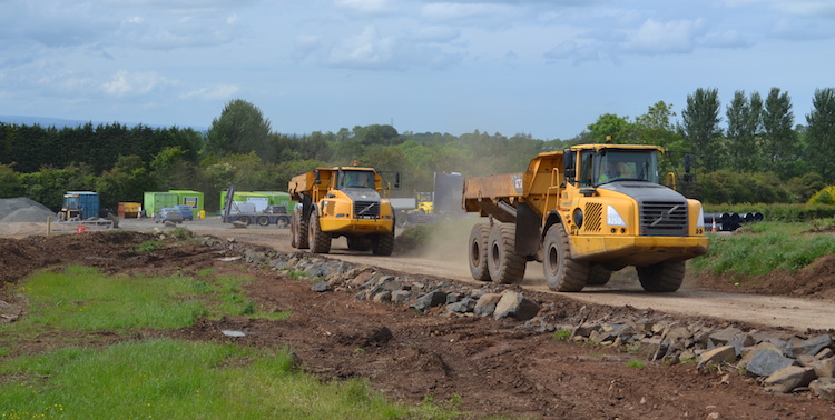
Heavy plant using a temporary access road on the
A6 scheme between Randalstown and Castledawson
c21 Sep 2017. This road has been made from rock
covered with earth to allow machinery to access
the various parts of the site. [Graham Farrans]
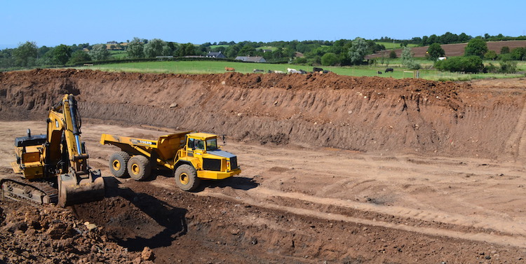
Excavation work underway between Randalstown and
Castledawson in late September 2017. [Graham
Farrans]
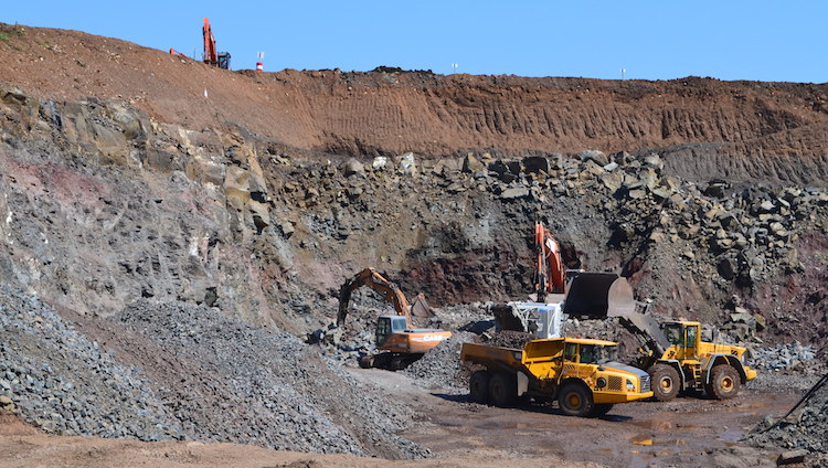
Very deep excavation underway about half way
between Randalstown and Castledawson. This is
either a deep cutting for the road, or a borrow
pit (to get material to construct embankments
elsewhere). c21 Sep 2017. [Graham Farrans]
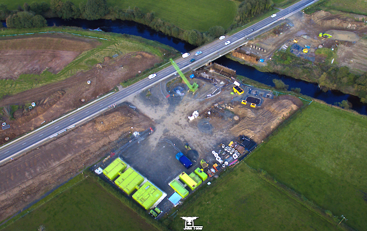
Work underway on 1 Oct 2017 to build a second
crossing of the River Moyola on the Castledawson
Bypass near the western end of the scheme. As
far as I am aware, the existing bridge will be
re-used for the future eastbound carriageway.
[John Toner]
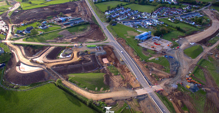
Bellshill Road grade-separated junction on the
Castledawson bypass taking shape on 1 Oct 2017,
looking west. Both current T-junctions will be
closed and replaced by a flyoer around the
middle of this shot. On the left is a new
embankment that will support a roundabout. The
earth road at the bottom of the shot is a
temporary access road. [John Toner]
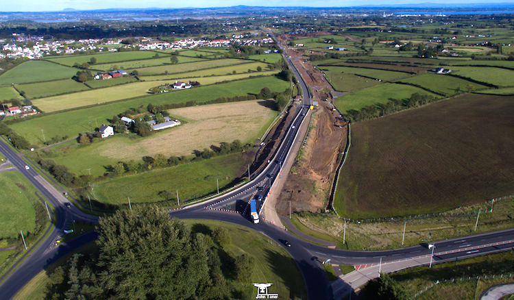
The western terminus of the scheme at the
Castledawson Roundabout, looking east on 1 Oct
2017. Two interesting things to see here -
firstly the recently-completed A31 Magherafelt
Bypass is heading off to the right. Secondly,
note the very wide area of earth to the right of
the A6 approaching the roundabout in the centre
of this shot. This embankment is only a couple
of hundred feet long, but dates back to the
construction of Castledawson Roundabout in the
early 1970s and was this wide because it was
intended to be the terminus of the M22 motorway,
which was never completed to its intended
terminus here. Part of it was re-used for the A6
Castledawson Bypass in 1992, but the new
dual-carriageway will cover the remainder. [John
Toner]
19 Sep 2017: Today saw the ruling on the
appeal by environmentalist Chris Murphy to the
judicial review that he lost in March. He was
challenging the legality of the DFI's
environmental assessments on the section of the
road between Toome and Castledawson (the legally
contested stretch being specifically the stretch
from the western end of the Toome Bypass to
Deerpark Road). In the event the judges
dismissed all of Mr Murphy's points and ruled
that the DFI had correctly complied with
relevant environmental legislation. The summary
judgement is available on the Courts Service web
site here.
Notably the judges expressed the view that a
delay of several years between a project being
approved and work commencing (as was the case
here and which Mr Murphy felt necessitated a
further assessment) is not unreasonable: "The
Habitats Directive imposes no time constraint
on the duration of an appropriate assessment
and in the case of major infrastructural
projects there is often a likelihood of some
time lag between authorization and
implementation of the project”. DFI, for
their part, immediately welcomed the ruling in
their favour with a press
release. Mr Murphy has the option of
attempting to appeal to the Supreme Court and
has indicated that this is an option he will
consider.
In their press release DFI says "As a result
of the judgement the Department will commence
construction of the Toome to Moyola River
section of the scheme which had been delayed
due to the legal challenge". By way of
background, DFI had previously agreed not to
begin major works on the stretch from Toome to
the Moyola River in Castledawson, so works
undertaken to date have been restricted to the
Randalstown to Toome stretch, and the bit west
of the Moyola River. The map below illustrates
the situation with the works already underway
shown in dark blue. The ruling means that DFI
are now free to begin work on the Toome to
Moyola stretch. However, a complication is that
the Environmental Statement imposes a
restriction that major earthworks (note, not
"all" works) cannot take place between Deerpark
Road and Toome between late September and mid
March. This is for environmental reasons and is
not directly related to the legal challenge. I
would define "major earthworks" to be anything
that involves constructing the bed of the road
itself, so I would consider embankments,
cuttings or bridges to be "major earthworks".
DFI have not said when they intend to start
work, but having now successfully defended two
legal challenges I would say they will be in no
mood for further delay and so I would expect to
see work begin on the Moyola River to Deerpark
Road stretch within days. We are likely also to
see minor works commencing on the contested
Deerpark Road to Toome stretch in the coming
weeks (eg vegetation clearance, fencing etc),
but we will not see major earthworks until mid
March due to the restrictions of the
Environmental Statement. Again, the map below
attemps to summarise this and help make sense of
all these different stretches.
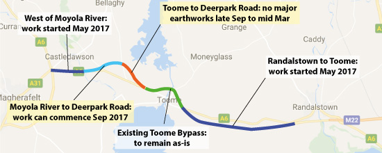
Status of the A6 dualling scheme as of 19 Sep
2017.
10 Jul 2017: Another wonderful aerial
movie of the scheme has been uploaded to
YouTube by John Toner, taken around the 1st of
July. It was taken on the Randalstown to Toome
stretch, beginning at the terminus of the M22
near Randalstown and moving west towards Toome.
The video description gives more details of what
you are looking at, but it shows earthworks now
underway at most locations and a site access
road now built. Most of the work seems to be at
the topsoil level, but there are signs of more
substantial earthworks in a few places.
29 Jun 2017: Work has now been underway
on this scheme for over a month, and already
there is a lot of progress. Site yards have
appeared and portable buildings painted in
Graham (the contractor) colours can be seen both
between Randalstown and Toome and on the
Castledawson Bypass. I have two sets of photos
which I haven't asked for premission to
reproduce here and hence am going to link to
them instead. The first two photos are
on Facebook here and were taken by Aerial
Vision NI. They show two views of the
Randalstown to Toome stretch, taken from a spot
about two miles west of the end of the M22. The
top photo is the view east towards Randalstown,
and the one below it is looking west towards
Toome. In the top photo you can see the existing
A6 on the left with site clearance and
earthworks very evident. Much of the earthworks
appear to be fairly close to existing ground
level, but in the second picture you can see
several excavators on an area of dark earth.
They appear to be in a field that's not part of
the scheme, so it may be a temporary area used
to store fill from elsewhere. The second three
photos were shared on
Twitter here by Kevin Bateson a few days
ago. They show work on the Castledawson Bypass,
specifically the area on the western bank of the
Moyola River, and taken from the existing A6.
The bridge here is due to be widened (or
replaced?) to accommodate the dual-carriageway,
which will be a major job. The first picture
appears to show a large excavation on the south
west side the bridge, which would be in keeping
with the construction of new bridge foundations.
So progress appears to be good. Less progress
can be reported on the legal challenge, which is
why no construction is taking place between
Toome and the Moyola River. Environmentalist
Chris Murphy is appealing his lost legal case
against TransportNI. This was due to be heard
two days ago for but reasons reported by the BBC
here,
it has been adjourned for another six weeks
until mid August. Hopefully this can be settled
one way or the other on that date, which seems
likely as the Appeal Court has indicated they
will give judgement on the same day. This
implies that the judge regards it as a fairly
straightforward question. I recently wrote an opinion
piece on the subject.
16 May 2017: Just a quick update to
share an aerial
movie of work underway on this scheme,
taken from a drone by John Toner on 10 May. The
footage is taken on the Randalstown to Toome
stretch, and begins by looking east from approximately
here. After about a minute moving east the
video halts and goes west again. What is evident
is how much has happened in the past fortnight
since proper construction began - access roads
have appeared along the whole stretch,
excavation of cuttings is underway and a whole
series of culverts (to carry watercourses)
appear to be under construction. It is great to
see so much work evident after such a short
time, and I am sure the glorious weather of
early May will have helped too. With thanks to
John Toner for sharing this with us all.
2 May 2017: The Department for
Infrastructure today announced
that they have at last signed the main
construction contract for the scheme and that
proper construction work will begin within the
next few weeks. Until now the only work that has
taken place has been site clearance and
archaeology which gets the site ready for work,
but doesn't involve building anything permanent.
However, DFI have also said that they will only
be commencing work now on part of the
scheme, namely the full Randalstown to Toome
stretch, plus the western end of the Toome to
Castledawson stretch, namely the bit west of the
Moyola river as far as Castledawson roundabout.
As this talk of parts of parts of the scheme is
getting utterly confusing I've produced the map
below to try to clarify what's going on:
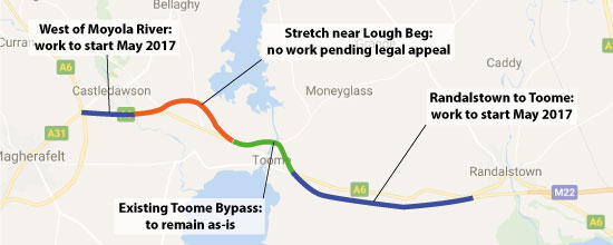 The reason they are not starting work on the
bit between the Moyola river and Toome is that
it is highly likely that environmentalist Chris
Murphy is about to launch another legal
challenge (an appeal to March's ruling in favour
of the DFI). He had been given four weeks, ie up
until 25 April, to do this but I understand the
judge later extended this to six weeks, which if
correct would be Tuesday 9 May (I haven't
confirmed this date). Currently there is nothing
legally preventing DFI starting work on the
entire scheme, since they won the legal case,
but it seems that they have decided not to
create unnecessary difficulties by proceeding on
this bit ahead of the appeal.
The key point is that the eastern half
of the scheme, Randalstown to Toome, will be
starting imminently and is unaffected by the
legal challenge. I see nothing to make me think
that this element is in any danger, and it will
likely be completed and be in use by the end of
2019, which will be very welcome for road users,
especially since the legal challenge has already
created a seven month delay. This eastern
stretch is also the more badly needed of the
two, being the lower standard of the two
stretches. The western half of the
scheme, Toome to Castledawson is looking more
uncertain. If DFI win the presumed appeal then
they can proceed with that stretch too, though
the timescale is longer, with completion
expected around 2021. Some have said that
today's announcement means that there will now
be no road close to Mossbawn or Lough Beg, but
that conclusion is not justified as it will go
ahead if Chris Murphy loses the appeal. But if
Chris Murphy wins then this stretch would be
back to the drawing board. Given the length of
time for planning a major new road (usually a
minimum of 3 years), tendering (if required,
perhaps 9 months) and construction (another 4
years) Mr Murphy winning the legal challenge
could mean that it could be 2025 before an
ugprade to this part of the A6 is completed.
However it is also worth noting that DFI have
successfully defended their planning process up
until now, and there is no particular reason to
think they'd lose an appeal. Today they said "The
Department will work to bring any future legal
proceedings regarding this section of the
route to a conclusion as soon as possible".
Having said all of that, there would be certain
things about the decade-old design that could
cetainly be improved should DFI be forced to go
back to the drawing board for the western
stretch. Apart from possibly changing the
proposed route of the road, they could also
delete the unnecessary Deerpark Road junction,
and grade-separate the junctions on the existing
Toome Bypass as should have been planned from
the start. After all, if a connection to
Deerpark Road, a minor rural road, can be
financially justified as a full grade-separated
junction, how on earth can not providing one at
Drumderg or Roguery Road roundabouts in Toome be
justified? Going back to the drawing board could
allow such anomalies to be removed.
13 Apr 2017: Environmentalist Chris
Murphy, who lost his legal challenge to the
scheme last month, confirmed in a new court
appeatrance on 5 April that he DOES intend to
launch an appeal (see Mid
Ulster Mail article). In a new court
hearing he sought an immediate injunction to
stop any work on the relevant portion of the
scheme (apparently, the Creagh to Hillhead Road
stretch), which the judge refused to grant,
saying it should instead form part of any
appeal. He has until 25 April to lodge an
appeal. Mr Murphy also confirmed in court that
although he had had his costs for the previous
challenge capped at £5000 (with the remainder
being funded by the taxpayer) he cannot afford
to pay this amount, leaving it unclear who will
pay for the shortfall. Even though TransportNI
are currently free to go ahead and commence
construction, it appears that they have only
carried out very limited work since they won the
legal challenge and the main construction
contract has not yet been signed. Regardless of
what happens with the planned appeal, I see no
reason why work could not at least begin on the
Randalstown to Toome stretch, though building it
in two stages is likely to cost the taxpayer
more money as the contractor will lose economies
of scale.
29 Mar 2017: On Tuesday 27 March the
judge gave
her verdict on environmentalist Chris
Murphy's legal challenge, exactly 6 months after
he launched it. She dismissed his challenge and
ruled that, contrary to his argued case, the
Department for Infrastructure had carried out
its environmental assessments appropriately,
that they were based on up-to-date information
and that they were accurate. She particularly
noted that both the NIEA and RSPB had withdrawn
their objections to the scheme. DFI welcomed
the announcement. The upshot of this ruling is
that work on the scheme can proceed immediately.
Chris Murphy has six weeks to appeal and in
subsequent media interviews he stated that he
intends to do so. For example, he disputes the
mitigation measures that NIEA and RSPB were
responding to, although on what legal
basis he would appeal is not clear from the
inverviews. He said that he would ask the judge
to give an injunction preventing DFI starting
work on the affected section (which, since he
destibed it as "2 miles" long presumably means
the Creagh to Hillhead Road stretch only, ie the
stretch that passes near Lough Beg). It is hard
to see why the DFI would agree to this unless
compelled to do so, since the scheme has passed
its public inquiry, has the political approval
of the last Executive (from both Sinn Fein and
the DUP), has a financial allocation, has now
been ruled lawful and has already been delayed
by six months by this challenge, whcih has
presumably cost the taxpayer hundreds of
thousands of pounds in the form of additional
costs incurred by the contractor putting staff
and machinery on hold. So, barring an inunction
from a judge, I would expect to see proper
earthworks getting underway on both halves of
the scheme in the very near future. Even if an
injunction were to be granted, work will at the
very least be able to continue on the
Randalstown to Toome stretch. In date terms, I
would expect to see Randalstown to Toome open by
the end of 2019 and the Toome to Castledawson
stretch by late 2020.
Ahead of the ruling DFI has done a lote of
preliminary site clearance work, mostly cutting
down trees and hedges and creation of site yards
but not any actual construction work. DFI also
took possession of the only home impacted by the
scheme about a month ago (the Vesting Order was
not part of the legal challenge). I drove along
this part of the A6 last week and it was clear
that the site clearance work was essentially
complete. But we are assisted by Scott Smith who
took a nice shot a few days ago on the stretch
between Randalstown and Toome showing how trees
and hedges have been removed, fencing to demark
the vested land erected and a site yard
established.
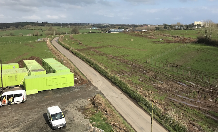
View north-east along Ballynafey Road (see here
for location) on 24 Mar 2017 showing fencing
around the vested land (on right), a site yard
(left foreground), tree felling (top right) and
hedge removal (along road). At this location the
new dual-carriageway will run from the top right
to bottom left, in a cutting, and pass
undernearth this local road which will be raised
onto a bridge. [Scott Smith]
26 Feb 2017: The judicial review was
finally heard in Belfast on 20th and 21st
February. To recap, construction of this road
was due to have begun in October 2016 but has
been on hold since then due to a legal challenge
brought by environmentalist Chris Murphy. Mr
Murphy presented his case on 20th as reported here.
Referring to the half of the scheme that lies
between Toome and Castledawson, Mr Murphy argued
that it has an unacceptable impact on a habitat
used by migrating swans close to Lough Beg.
Legally speaking, it is his contention that the
DFI has not carried out an adequate assessment
of the impact on this habitat because the
original survey work was done over ten years ago
and some factors have materially changed in that
time. He claimed that the DFI had tried to
"circumvent" the procedures around such matters.
Some have also objected to the route on the
grounds that it goes close to Seamus Heaney's
home and passes through a culturally-significant
landscape referred to repeatedly in his poetry.
However this point didn't seem to feature in the
court case. The DFI presented their defence on
21st as reported here.
They admit that the route passes close to the
overwintering swan habitat, but point out that
it doesn't pass through it and claim that swans
have been observed feeding right up to the edge
of the Toome Bypass (which opened just over ten
years ago, and also passes close by) and hence
the road is unlikely to impact the swans. They
argued that any impact on the habitat would be
"small". They further argued that the Vesting
Orders (which compel landowners to sell the land
required for the road to the DFI) were not being
challenged by Mr Murphy, which meant that if the
judge ruled against the DFI, they would be left
holding acres of vested land paid for by the
public purse but with no use for it. The judge
will now take some time, perhaps some weeks, to
consider the cases made by the two sides and
will then make a final ruling. This ruling will
make clear the next steps for this scheme.
8 Feb 2017: The long-awaited judicial
review that has caused the main construction
contract to be on hold since October is to be
heard later in February. In the interim, a
preliminary siteworks contract continues with a
lot of tree-felling work evident on both the
Randalstown to Toome and Toome to Castledawson
stretches in the past weeks. The outgoing DFI
Minister has released a short
video on Twitter which contains some
aerial shots of the works underway - the start
of the sceme at Randalstown is seen around
00:10, an area around Drumderg Roundabout in
Toome at 00:31 and finally the terminus at
Castledawson roundabout around 00:40. The legal
challenge is only to the western half of the
scheme (Toome to Castledawson) and the Minister
seems confident that the outcome of the judicial
review will, at the very least, allow the main
construction contract to begin on the
Randalstown to Toome stretch in March after the
judicial review outcome is known. This would be
very good news for supporters of the scheme. We
will have to wait for the judicial review itself
to know for sure since it will ultimately by up
to the judge to decide on this point, and there
is a worse-case possibility that a judgement
against the western half could impact the
eastern half too. The best-case scenario, for
the DFI, would be that they win the judicial
review in its entirely. In the video the
Minister also says that "the money for this
project is secured" and that is correct,
since the full amount has already been budgeted
and approved by the Executive (December 2015),
and a contractor is already in place, and hence
even the election and the possible delay in the
creation of a new Executive should not impact on
commencement of this scheme.
1 Jan 2017: This update has been added
merely to note what has not happened
since leave was granted in November for a
judicial review into the Toome to Castledawson
stretch of this scheme (the western half). There
was a question at the time as to whether this
would also delay the eastern part of the scheme,
Toome to Randalstown, even though the judicial
review did not affect it and the answer now
seems to be “yes”. Work on the main contract was
to have begun in October, and it is now the
start of 2017 and it has still not begun. To
date the only work that has taken place is a
separate advanced site works contract (thing
like vegetation clearance, archaeology). In a Written
Answer in the Assembly on 14 December (AQW
8404/16-21) the Minister noted that the legal
hearing doesn’t seem too far away: “A
Judicial Review hearing … relating to the
Habitats Directive will be heard early in the
new year”. He then went on to note that “if
the outcome of the hearing goes against my
Department, contingency measures are being
explored to advance this section to
construction in this financial year”. That
wording suggests that we will see NO work take
place on any of the main contract before we know
the outcome of the legal challenge. This
unfortunately means that the Toome-Randalstown
stretch will be delated by perhaps six months,
which will be frustrating given that (a) it is
the worst standard stretch of the entire A6 and
(b) is not being challenged by Chris Murphy. The
Minister’s wording also does not sound
definitive as to whether it will actually be possible
to advance part of the scheme if the hearing
goes against the Department. That presumably is
dependent on the outcome of the judicial review.
24 Nov 2016: Today the judge gave his
verdict to the application for a judicial review
into this scheme, and has decided to grant
leave. There is so much to say on this subject
that I have explored it more fully over
on my blog. But for the purposes of this
progress update, this means that there will be a
further legal hearing, probably in January with
a judgement expected some weeks after that. If
the challenge succeeds then the western half of
the scheme (Toome to Castledawson) may not be
going ahead for several years. If the challenge
fails, then work on the western half could get
underway early in 2017. What the implications
are for the eastern half (Randalstown to Toome)
is less clear. This portion was not subject to
the legal challenge, though it is part of the
same construction contract, and the Minister
has said the he is keen to explore options
for proceeding with it straight away. Whether
this is possible will depend on exactly what
environmental assessments are affected by the
challenge and whether these overlap with the
eastern part of the scheme. Certainly one of the
Minister's advisors seemed
confident tonight. Once again we are in
the position of waiting.
14 Nov 2016: As stated in the previous
update, the application for a judicial review
into this scheme, which has been brought by a
private individual (Chris Murphy) is currently
underway. The first date (28 Oct) was not
sufficient to hear all the evidence and the
hearing was adjourned. A second date has now
been set of 10am on 21 Nov 2016. Hopefully this
second date will provide sufficient time to hear
all the evidence and allow the judge to come to
a decision as to whether to allow the judicial
review. The evidence that has been presented so
far has gone into considerable depth, so we will
have to reserve comment on the matter until we
hear what the judge makes of it all. Meanwhile,
the advance site works contract is still
underway - this is separate from the main
construction work which is currently on hold.
28 Oct 2016: The legal challenge
(application for a judicial review into the A6
dualling scheme) was heard today in the High
Court in Belfast. According to Seamus
Leheny (FTA), who attended the hearing,
the substance of the challenge was "quite in
depth but focused on legality of environmental
habitat assessment". Unfortunately the
hearing ran out of time today and has been
adjourned and will have to wait until another
day is allocated at the High Court to hear more.
Part of the legal challenge is a request that
the court stop construction work. Although a
separate advance site works contract is
currently underway, the main contract has not
yet begun. Since the legal challenge only
affects the western half of the scheme (Toome To
Castledawson) the big question is whether or not
work on the the eastern half of the scheme
(Randalstown to Toome, aka the notorious
Moneynick Road) can begin in the interim since
it is unaffected by the legal challenge. Nobody
seems to be able to give me a straight answer
to this simple question. Two things are
clear: (1) the scheme is legally in two halves,
ie they went through all the statutory processes
independently (2) both are, however, being built
by the contractor as part of a single contract
which was awarded to Graham/Farrans joint
venture. I was recently contacted by a resident
impacted by the scheme who said the same thing:
that both TransportNI and the contractor had
assured them that the two halves were separate,
but yet a Sinn Fein special advisor to the
Deputy First Minister has said that the entire
contract has had to be stopped because of the
legal challenge. The Minister seemed to say the
same thing in a Written Answer in the Assembly (
AQW 4475/16-21) when he said "the Department
is completing preliminary advance works which
had commenced prior to the receipt of the
Application for Leave papers. The main
construction works are not being progressed."
I have asked this question directly several
times but have not had a clear reply, so perhaps
nobody actually knows the exact situation. One
other thing is clear - works were supposed to
get underway in October, and it is now the 28th
and it has not started, so this at least
suggests that no work is going to take place on
either bit of the new dual-carriageway until
this legal challenge is settled. This will be
immensely frustrating both to road users and the
contractor, and indeed for those whose
properties are affected since their plans to
move house are now also on hold pending a
possible overturning of the Vesting Order. Let's
hope that the Courts can conclude this hearing
to give some certainty to everyone affected
within a short timeframe.
2 Oct 2016: The "Vesting Order" for this
scheme became active on 27 September. This is
the legal procedure that transfers ownership of
the land required for the scheme to the
Department for Infrastructure, although the
exact amount of financial compensation has yet
to be worked out in all cases. On the same day a
"private individual" lodged
a legal objection to part of this scheme
at Belfast High Court. The scheme is legally
composed of two parts (Randalstown to Toome and
Toome to Castledawson) and as far as I can tell
the legal action only affects the second part.
Therefore work on the Randalstown to Toome
section can commence on the ground as planned
during October under the contractor,
Graham/Farrans Joint Venture. This stretch is
almost entirely offline so regular road users
will probably not notice much happening as the
work will largely take place out of sight of the
existing A6.
Whether work can start on the Toome to
Castledawson section will depend on what the
High Court makes of the legal challenge, and
it's not yet known what grounds the objection
are being made on. If the legal challenge fails
then work can begin on this stretch, too, within
the next few weeks. The main objection seems to
be that it passes close by Seamus Heaney's
former home and through a landscape that
inspired a number of poems. A concert
was held in the Lyric Theatre in Belfast last
week by opponents of the scheme. This week saw a
bit of a war
of words about the scheme with Seamus
Heaney's brother suggesting that local people,
including himself, supported the scheme whereas
Seamus Heaney's son questioned the route that
the road is to take. Certainly a web page set up
to crowdsource
funding for the legal challenge isn't
particularly compelling in terms of indicating
widespread support. But the challenge will be
decided on legality, not popular opinion, and so
it is Court's decision that we must wait for.
17 Sep 2016: A lengthy update today as
there is much to say. We are now very close to
this scheme finally getting underway - the final
detailed design has been ongoing for some
months, and construction work is due to get
underway within the next few weeks with the
contractor (Graham/Farrans) already gearing up
to begin. Only a few days ago we learned that
there was to be a legal challenge to the A5 scheme,
but yesterday we learned that opponents to this
scheme on the A6 (a different group from those
challenging the A5) intend
to launch a last-minute legal challenge to
this scheme. It seems that the concerns focus on
the impact on the landscape here, which was once
home to Seamus Heaney, and its impact on
wildlife. I outline these concerns in more
detail below. All these issues were, of course,
discussed at the Public Inquiry in 2007 and from
reading the Environmental Statement there is no
doubt that it is an environmentally sensitive
area. TransportNI’s proposals passed the 2007
Public Inquiry and from TransportNI’s point of
view that ought to be the end of the matter.
However, the issues that were discussed back
then remain concerns for those involved and it
seems that the imminent start of construction
has brought them back into public light. For
example tomorrow night a concert
is being held at the Lyric Theatre in
Belfast to raise awareness of the issues - a
most interesting event, as I believe it is the
first time a concert has ever been held to
oppose a road scheme in Northern Ireland!
I have been in touch, via Twitter, with one of
the leaders of the opposition group, James Orr
(who works for Friends of the Earth though note
that FoE is not the group launching the legal
action). Mr Orr clarified that the challenge is
being brought because of what he feels is “several
flawed assessments”, specifically the
absence of a Strategic Environmental Assessment
to look at alternatives, what he believes to be
a flawed Environmental Impact Assessment, and “out
of date info, eg this land now floods”.
Conor Macauley of the BBC has also put together
a video
exploring the objections and TransportNI's
response. The requirement on TransportNI to
carry out appropriate assessments is all set out
in law. A legal challenge can be brought if
someone has reason to believe that the
Department for Infrastructure not carrying out
its work in a way that complies with
legislation. It is important to stress that it
is every citizen’s right to launch such a
challenge as part of the process of government
accountability. If the legal challenge succeeds
then it would mean that the Department had not
complied with legislation, in which case the
challengers would be vindicated, the Department
would be at fault and the road could be delayed
by several years or possibly not be built at
all. If the legal challenge fails, then it would
mean that the Department had complied with
legislation, i.e. had done everything properly,
and construction of the road could proceed as
planned. We will have to see which outcome
results.
It has to be said that one weakness in the
Department’s position is that it is now nine
years since the scheme had its public inquiry,
and seven years since it was deemed to have
passed the Inquiry via the Departmental
Statement. At that time I don’t think anyone in
what was then Roads Service anticipated that it
would take this long for funding to be allocated
by the Executive, which is the fundamental cause
of the nine year delay. It is conceivable
(though I don’t know either way) that something
material might have changed in that time and the
legal challenge may zero in on this question.
(If that turns out to be a make-or-break issue,
it will impact other schemes that have had their
public inquiries but not proceeded to
construction, such as the A55 Outer Ring upgrade
at Knock in Belfast which had its public inquiry
in 2010 but has still not begun.) Additionally
elements of the Departmental
Statement released in 2009 contained
statements of intent to carry out work as part
of the scheme which have since been quietly
abandoned, e.g. the grade-separation of Drumderg
roundabout on the existing Toome Bypass. This,
too, may be a weakness in the Department’s
position, though again I do not know whether
that is actually the case. The courts will have
to judge.
Leaving aside the merits, or otherwise, of the
legal challenge this will be frustrating to
supporters of the scheme, mainly residents of
the North West, business interests in the North
West and the travelling public because this is
the lowest-standard stretch of road between the
province’s two cities and has a poor safety
record. An upgrade to the stretch has been
planned since 1964 and politicians in the North
West have been campaigning for a road upgrade
for some decades, and we are now closer than at
any point since the 1960s to it actually
happening. The organisation most likely to be
upset by a delay is Sinn Fein, and in particular
Martin McGuinness who has made upgrades to the
A5 and A6 critical policies for the Executive
and they will be particularly frustrated that
both schemes are being subjected to legal
challenges and potential delays simultaneously.
Whatever way the legal challenge goes it is
likely to create heated debate, as has certainly
been evident on Twitter over the past 24 hours.
I think it is fair to say that everyone involved
is sincere in only wanting what is best for
society - they simply disagree on what the
“best” actually is.
17 Aug 2016: The new DfI Minister held a
press conference this morning where he
announced that construction of this scheme
will begin in October. The scheme already has
both funding and a contractor, but time has been
occupied over the past few months by detailed
design work and completing the statutory
processes for the one outstanding junction (see
previous update below). He said that
archaeological work would begin within the next
week and the Vesting Order will be "made" in
September. The Vesting Order is the legal
document that transfers ownership of the land
from the landowners to TransportNI. It has
existed in draft form for some years now, but
the formal "making" of the Vesting Order is what
makes it actually happen. The contractor,
Graham/Farrans Joint Venture, will be getting to
work on the ground in October. This scheme has
one of the longest construction periods I have
seen for a road scheme in many years. The
Minister said that the eastern part (Randalstown
to Toome) would be opening in 2019, with the
western part, which has more environmental
constraints such as Whooper Swans, opening in
2020. I did raise my eyebrows at the estimated
cost of £160m, given that the Minister quoted a
figure of £150m only two months ago, and in late
2014 the cost was still being given as
£120-140m. So there have apparently been some
last minute cost escalations. The scheme is very
positive - first and foremost it will upgrade
the worst standard section of the entire
Belfast-Derry route, which has claimed many
lives over the years and really needs a safety
improvement. Secondly, it will make the journey
that little bit easier and also more reliable in
time terms, while reducing the congestion at
Toome in the rush hour. The only down side is
the decision to retain the existing roundabouts
on the Toome Bypass. I have said many times that
I think this is a mistake akin to creating
another Hillsborough roundabout situation. I am
quite sure in 20 years we will be talking about
why this was done and will be considering an
upgrade. But I do not want to be negative either
- the scheme is overwhelmingly a good thing, and
great news that it is finally going ahead. One
piece of trivia to end - the A31 Magherafelt
Bypass is currently under construction and is
due to be completed in October. Both it and this
A6 scheme terminate at the Castledawson
roundabout. So for a few weeks in October we
will have two separate road schemes underway at
the same time, both of which terminate at the
same place, a rare event indeed!
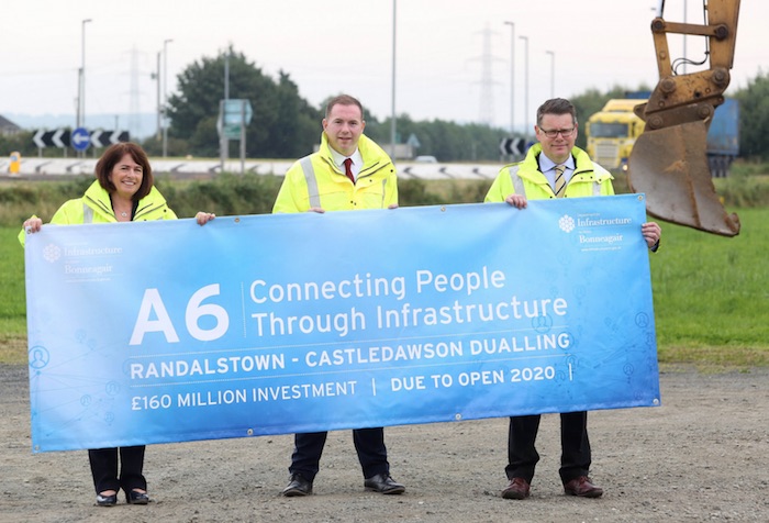
Deidre Mackle (TransportNI Divisional Roads
Manager), Infrastructure Minister Chris Hazzard
and Andrew Hitchenor (Strategic Road
Improvements Manager at TransportNI) at today's
press conference. Image
from here.
9 Aug 2016: It's been seven months since
the previous update. Not much has been visible
on the ground, but plenty has been going on
behind the scenes. Firstly, the controversial
Bellshill Road/Annaghmore Road grade separate
junction has finally been settled after
three public inquiries. On 18 May 2016 the DfI
(the department which has taken over from the
old DRD) issued their Departmental
Statement which confirms that following
the third public inquiry they are proceeding
with the revised design. This was the only major
outstanding design issue that could impact on
project start so it is great that that is now
resolved. Detailed design work has been ongoing
during the spring and summer and is almost
complete. Archaeological works are due to begin
later this month. The contractor could possibly
be on site, then, in late September ("subject to
final approval of the business case" within the
DFI of course). One place that will be a
restriction on the contractor is the stretch
between Toome and Deerpark Road junction which
crosses a feeding round for Whooper
Swans. This means that no work can take
place on this stretch between September and
March, so work there will have be focused on the
late spring and summer. Finally, in a Written
Answer in the Assembly in mid June (AQW
372/16-21), the DfI Minister quietly slipped in
that the total cost of the scheme has now risen
to £150m (up from £120-140m as of November
2014), representing a further rise. The cost is
now more than double the estimate of £70m in
2006. This sort of cost escalation is repeated
in almost every road scheme as it progresses
through planning and is a combination of
progressively more complex designs and early
optimism. If the scheme does begin in September
2016, then adding the (rather lengthy)
three-and-a-half year construction timescale to
this, completion can be expected in early 2020!
28 Jan 2016: A long update tonight as
there is much to say! In a Written Answer in the
Assembly last week (AQW 52171/11-16) the DRD
Minister gave more information about timescales
for the start of this scheme.
She explained that there is still "ongoing
detailed design work [which] will be complete
by spring / summer 2016". In other words,
the scheme was not quite "shovel ready" as I had
thought when the money was allocated. She goes
on to say that the project will "commence in
summer / autumn 2016". This is a bit later
than she said in the Assembly a few weeks ago
(see update below for 11 January) so it suggests
there is still a good bit of work to be done
before the bulldozers can roll in. The DRD have
now
placed PDFs of the current design of the
scheme on their web site. The current "detailed
design" work will not affect this design much -
it is more likely to be more technical design
such as the depths of excavations required,
extent of piling for bridge structures etc. This
scheme is extremely welcome, since the Moneynick
Road in particular (the bit from the end of the
motorway at Randalstown to Toome) is the most
sub-standard part of the entire Belfast-Derry
road.
Next, I want to comment on the duration of
the scheme. I was rather taken aback by
quotes from the DRD quoted in the media two
weeks ago that the scheme would take "three and
a half years" to complete. This is a good bit
longer than the "24 months" estimate given in
2010 and seems an astonishingly long time for 8
miles of road - the A1 Newry Bypas for example
is 8 miles long and took two and a half years
despite requiring explosives to blast away
thousands of tonnes of rock. I had hoped that
this was a misunderstanding, but I spoke to an
official at the DRD who confirmed this timescale
and said this was based on the A8 Larne dualling
scheme, recently
completed, that also took a similar length
of time. Now, this is true (that scheme lasted 3
years and 4 months) but it does give us some
hope, because in the case of the Larne scheme
the road was fully open after 2 years and 9
months, and the remaining 7 months were occupied
by landscaping works. So I would say, fear not -
it's likely that the road will be in use sooner
than three and a half years. The most
straightforward stretch is Randalstown to Toome,
since it is entirely offline away from the
current road and has no junctions on it, so I
would place money money on this stretch being
open and in use within two years or so of
project commencement (say, by autumn 2018), with
the Toome to Castledawson section following
after perhaps three years (so, late 2019).
Now
I cannot continue without mentioning the two
existing roundabouts on the Toome Bypass.
Although the Departmental Statement issued
back in 2009 explicitly stated that the
DRD would grade-separate at least one of them,
Drumderg roundabout, as part of the scheme,
this no longer seems to be happening. We know
that the Roads Service Board approved a plan
to upgrade the Toome Bypass in January 2009.
Minutes of a DRD Board meeting I saw back then
(but no longer online) say "The Board
discussed Mr White’s 22 January 2009 paper,
A6 Randalstown to Castledawson Dualling, and
approved the recommendations listed to amend
the design at the Annaghmore and Bellshill
Road junctions, grade–separate the Drunderg
roundabout, remove the Roguery Road
roundabout and the Castledawson roundabout
to remain ‘at grade’." In December 2009
the DRD even published a plan for how they
would upgrade the Toome Bypass on their web
site (see my update below for Dec 2009) but
this document now seems to have disappeared.
The fact that Roguery Road and Drumderg
Roundabouts will remain in situ after this
project is complete is a mistake that mars an
otherwise excellent project. The two
roundabouts sit right in the middle of the
dualling scheme. Two of the key objectives of
the scheme are to "reduce journey times"
and to "reduce congestion and delays".
These roundabouts clearly increase journey
times and will create delays - when compared
to a free-flowing road. The roundabouts will
also be anomalies in that they will be the
only at-grade junctions between York Street in
Belfast and Castledawson - every other
junction will be grade separated. I do not
accept the DRD's explanation that the
roundabouts are justified because they have
sufficient capacity. They are factually
correct that the roundabouts will have
sufficient capacity, but this argument does
not make sense in light of the stated
objectives of the dualling scheme as quoted
above. If this logic were carried though,
every junction on the upgaded road might as
well be built as an at-grade roundabout. Nor
does this explanantion explain the
enthusiastic plan to upgrade the Bypass that
was approved in 2009. The "Toome roundabouts"
will become the "Hillsborough roundabout" of
the A6. I have asked but nobody at TransportNI
seems to be able to offer any explanation for
why neither of these roundabouts is now to be
removed.
11 Jan 2016: In a press
release yesterday, and today
in the Assembly, the DRD Minister
announced what we widely expected, namely that
this scheme will be going ahead soon (see
my
blog). I had predicted that work would
begin in April, based on the fact that this is
when the funding allocation would begin and the
fact that the scheme was "shovel read". However,
the dates given today are slightly later than
this - the press release says "work on site
expected to start by the end of the summer",
although in the Assembly the Minister said "We
are hoping that it is going to happen at the
start of the summer". Why the later date
than I anticipated? The press release states
that the detailed design work I mentioned in the
November update below is still ongoing: saying "detailed
design work is progressing". So it seems
that the scheme is not quite shovel
ready. But we'll not be churlish on this point,
since it's certainly a lot closer to being
shovel ready than it would have been had the
previous DRD Minister not progressed the lengthy
procurement process over the past year. So what
happens next? The DRD have to actually buy
the land needed (known as "making" the Vesting
Order) so this will also have to happen once the
money is available (April). Once the land is
purchased it will need to be fenced off - this
is usually the first thing observers actually
see happening on the ground - followed by
vegetation clearance. The contractor will also
need time to gear up, constructing their site
yards and getting machinery and portacabins etc
onto the site. Only after all that will we see
actual earthworks starting, and it looks as if
we can expect that to be underway during the
summer. In terms of timescale, the last official
estimate in 2010 was that it would last 24
months, but I haven't seen an updated estimate.
The Minister seemed rather vague on the point,
saying only that "with a fair wind, it should
be completed around 2019" (in the Assembly
today). Even January 2019 would be about two and
a half years after a summer commencement, and I
would hope that it wouldn't take much longer
than that. I would be a bit more optimistic and
say it could be complete before the end of 2018
- but that's not "official"! Road users should
not experience too much disruption
during the works since the road is almost
entirely offline - except for a couple of
locations either side of Toome, and a short
stretch at the Castledawson end where the new
road subsumes the 1992 Castledawson
Bypass. Finally, once work gets
underway we will have a very rare scenario where
two independent road schemes under active
construction terminate at the same point - the A31
Magherafelt Bypass also terminates on the
Castledawson roundabout and is also under
construction. Let's hope the two sets of
contractors don't get in each other's way!
19 Dec 2015: Two days ago the Finance
Minister delivered her budget
for the next financial year. This budget
included funding of £21m in the 2016/17
financial year (April to March) for the A6 and
also committed £57m, £60m, £60m and £60m for the
following four years. This is more than enough
money to allow this scheme to be built. Given
that it is "shovel ready", ie all planning is
completed and a contractor is in place, I think
it is highly likely, therefore, that
construction on this scheme will commence in April
2016 and be the next major road scheme in
Northern Ireland, allaying the fears I expressed
in the previous update. This timescale is my own
speculation, and has not been confirmed by the
DRD, but I cannot think of any reason why this
should not be the case.
29 Nov 2015: This is currently the only
road scheme that is "shovel ready", but not yet
commenced, in Northern Ireland. Over the past
year I have taken the view that this scheme will
be the next major road scheme in Northern
Ireland to get funding to proceed to
construction. I still think this, but it has to
be noted that the degree of support that has
been given to the A5 project by the DUP and Sinn
Fein (in the document "A
Fresh Start: The Stormont Agreement and
Implementation Plan" published on 17
November) means that there is a possibility that
it will get pushed down the priority list.
However, it remains the case that this scheme is
the only one that is ready to go to construction
right now (even the A5 still needs
another public inquiry, while York Street
interchange has only just had its inquiry) so if
funding were to be come available within the
next few months, this scheme is the only real
contender. Beyond a few months these two other
schemes will approach a "shovel ready" state
themselves, which would muddy the waters a bit
in terms of what could go ahead first. Meanwhile,
design work is continuing on this scheme. This
has involved some site investigation works over
the past month or two, which are now completed.
These include locating and monitoring ground
water levels, and the work will have been
evident to road users passing by. To be clear,
this is not construction work on the road itself
- these works are intended to inform the
detailed design process. With thanks to Patrick
Duffy for some observations on this scheme.
29 Oct 2015: It seems that a minor
Public Inquiry was held on 29 September into the
Vesting Order for the Bellshill/Annaghmore
junction. This one sneaked past me, and I only
found out about it when the
documents were posted on the DRD web site
this week. The Inquiry was very limited in
scope: not examining the proposed bypass, or
even the proposals for this junction, but merely
the decision to vest extra land in order to
excavate an extra area of low ground to provide
capacity for floodwater during heavy rain. The transcript
of the public inquiry shows that it was not a
rubber-stamping exercise, but involved some
debating which got rather heated on occasion. It
does not say whether or not the Inspector has
produced his report (unlikely in just four
weeks), or what his recommendations might be,
but I would be surprised if the Inspector's
Report does not approve the plan. With the
Deputy First Minister recently
suggesting that progress on the A5 and A6
are "red line" issues for him, I am still of the
view that this scheme will be the next major
road scheme in Northern Ireland to get the
go-ahead, even against the other scheme that
seems to be a high priority, the York Street
Interchange in Belfast. If it does not,
then I think there would be something wrong with
the decision making progress.
13 May 2015: It was announced
yesterday that the contract for construction of
this road was awarded to Graham/Farrans joint
venture on 1 May. It is important to stress that
even though the scheme has gone through all its
statutory processes and a contractor appointed
the scheme is not going to be built just yet,
because as yet there is no money for it. What it
does mean, though, is that Graham/Farrans
will now progress the design of the road up to
the point that work could begin within weeks of
money being secured. This process by which a
contractor is involved in detailed design ahead
of actual construction is called "Early
Contractor Involvement" (ECI) and it has been
used very successfully on other recent schemes,
such as the A8 dualling to Larne. TransportNI
seem convinced that ECI brings benefits in terms
of foreseeing problems earlier on when they are
cheaper to resolve so expect to see it become
standard on large schemes in the years ahead. As
far as I know the Vesting Order (which compels
landowners to sell the land needed to
TransportNI) has not yet been "made" (ie, they
haven't actually pressed the button and bought
the land). So when money does get allocated to
this scheme you can expect to see the Vesting
Order being "made" as the first step, and then
construction getting underway as the second
step. TransportNI are saying nothing publicly
about when the scheme might begin, but some
folks I've spoken to seem privately hopeful that
money will be secured within two years. Having
said that, there is an Assembly election in that
period, so we may have a new DRD Minister by
then, so who knows? Nevertheless, I would be very
surprised indeed if this is not the next major
road scheme to get funding in Northern Ireland.
28 Jan 2015: The good news for this
scheme is that the last remaining obstacle - the
design of the grade separated junction at
Annaghmore Road/Bellshill Road has been
resolved. Planning permission was granted
on 3 December 2014, which means that the scheme
is now 'good to go'. A process to appoint a
contractor has been underway now since July. As
explained in the update on 14 Aug 2014 (below)
this is to get the scheme "shovel-ready" so that
it can begin if money becomes available. The
Northern Ireland budget for 2015-16 was published
earlier this month, and unfortunately
TransportNI have been given no funding for this
(or indeed, any further) new road schemes for
the period 2015/16. So that means that, while a
contractor will likely be appointed during the
first half of 2015, there is no prospect of
construction beginning before April 2016 at the
earliest.
7 Dec 2014: There have been a few
developments in this scheme. Firstly, the
process to appoint a contractor for the scheme
is ongoing. As noted in the previous update
(below) this is to get the scheme "shovel-ready"
so that it can begin if money becomes available.
Currently there is no funding allocation to the
scheme, so the appointment of a contractor does
not mean construction will get underway. However
in the minutes of a TransportNI board meeting
held on 1 October (but just published)
there is the comment that "DFP [Department
of Finance] has given approval to proceed with
the Phase 1 of the project". This is a
critical comment, since a funding allocation
from DFP is the one remaining obstacle to the
scheme getting underway once a contractor is
appointed. Note however the reference to "Phase
1", which appears to mean that the funding is
NOT for the whole of the scheme from Randalstown
to Castledawson, but only part of it. It does
not explain what "Phase 1" refers to; however I
would speculate that it refers to the
easternmost stretch from Randalstown to Toome
which has been through all statutory processes
and has no obstacles other than finance to
overcome. The westernmost stretch still has one
outstanding issue, which is the design of the
grade separated junction at Annaghmore
Road/Bellshill Road, which remains stuck in the
planning
process. Interestingly the Planning
Service web site says that a decision on this
issue was made on "3 December" but the site does
not yet say what the decision is. We will have
to wait and see. Finally, in
the Assembly on 18 November the Minister
confirmed that the cost estimate for the scheme
is now £120-140m. This is a bit more than the
previous estimate of £100-120m given in 2010. I
am still of the view that this scheme will be
the next new road scheme in Northern Ireland to
get funding (the previous two being the A31
Magherafelt Bypass and the A26 Frosses Road
dualling which are both due to begin in 2015).
14 Aug 2014: The tender
for construction of this scheme was
finally released on 28 July 2014, much later
than anticipated back in March (see below).
Strictly speaking what has been released is
merely the first round of the process, during
which a list of prospective tenderers is drawn
up. The "proper" tender process will then take
place afterwards out of the public eye. But to
the layperson it's all part of a single process
that results in a contractor being appointed.
The total cost of the construction work (ie, not
including land purchase and planning costs) is
given as £95m-£115m. As this is quite close to
the overall project cost of £100m-£120m
being given in April 2010, the final cost
including land could well come in higher than
this. Contractors have until 28 August to
express interest in tendering, with the tender
itself due to be released to selected
contractors on 17 November. We could therefore
expect to see a contractor appointed during the
Spring of 2015. It is important to stress that,
unlike other recent schemes, this scheme has no
funding to proceed to construction, so the
appointment of a contractor will NOT lead to
work beginning on the ground (unless money is
given to the scheme by the Department of Finance
in the interim). The plan seems to be that the
scheme can be got ready to a point that, should
money be made available at some point in the
future, construction can begin rapidly, perhaps
within a matter of weeks, since the contractor
will have been appointed. This is not an ideal
situation for the winning contractor, but the
best that can be achieved in the circumstances,
and is laid plan by observing that the time
limit for completion of the work is given as 28
February 2026, which is appropriately
vague!. Meanwhile, there has been no movement
over the past 6 months on the main outstanding
issue, which is the design of the grade
separated junction at Annaghmore Road/Bellshill
Road, which remains frustratingly mired in the planning
process.
1 Mar 2014: The DRD web site is now
giving notice of a construction
tender, to be released in April 2014.
Procurement normally takes about 9 months, so we
could expect to see a contractor appointed by
January or February 2015. However, this scheme
has not yet been given any funding, so what is
going on? It seems that this is a "no value
Framework contract" (explained here)
which splits the contract into two parts:
design, and then construction, but with no
guarantee that the construction phase will
actually occur. This is similar to the way the
contractors for the A5
scheme were appointed. The DRD explain
that "This form of contract allows the
appointment of a contractor and progresses the
scheme to a “shovel ready” position, allowing
construction to commence immediately funding
is confirmed." Presumably the hope is that
the scheme can be got ready to a point that,
should money be made available at some point in
the future, construction can begin rapidly,
perhaps within a matter of weeks. This would
seem to be a sensible approach. The only other
outstanding issue is the design of the grade
separated junction at Annaghmore Road/Bellshill
Road, which is still awaiting
planning approval.
5 Nov 2013: Although
this scheme has failed to get an allocation in
the latest
funding round to allow construction to
begin in the period April 2014-April 2015, it
was given a smaller allocation to allow design
and preparation work to continue which will at
least ensure that it is "shovel ready" when
money does become available. There is the
outstanding matter of the design of the grade
separated junction at Annaghmore Road/Bellshill
Road, which is still awaiting
planning approval. The NI Executive's
position on this scheme remains unclear. The
Finance Minister who made the announcement said
"Importantly, the A6 preparatory work does
not commit the Executive contractually to that
project. The Executive took the view that,
until there is clarity on the A5 project, we
cannot afford to commit contractually to the
A6 project, since delivering both in parallel
is unaffordable without there being a serious
detrimental impact on all other departmental
capital budgets." This seems to mean that
the A6 scheme is so expensive (almost twice the
price of the A26 dualling scheme north of
Glarryford that did get funding) that the DRD is
not prepared to go ahead with it while there is
still a chance that the A5 scheme could resume,
as there would not be enough funds to complete
both at the same time. This means that the A6
scheme is, effectively, still dependent on the
outcome of the A5 scheme. Since further
decisions on the A5 are unlikely in the next six
months or so, it looks like this scheme will
remain in limbo for some time yet.
5 Jul 2013:
As outlined in the discussion further up this
page, the one outstanding issue on this scheme
is the design of the Annaghmore Road/Bellshill
Road grade separated junction at Castledawson.
The initial design was rejected at the 2007
public inquiry. A revised design was then
rejected at the 2012 public inquiry. The issue
seems to be the proximity of proposed link roads
to houses in the area. As anticipated, the DRD
did indeed submit
their third proposed design for planning
approval on 27 June. The link I have given
is to the planning service web site, where you
can download detailed designs, but here is a shortcut
to the relevant map [4MB] showing the
design. It differs from the previous proposal in
that the link road joining Annaghmore Road and
Bellshill Road no longer passes between two
housing developments, but instead passes further
to the east of the built up area, as was
suggested by the public inquiry inspector. The
design has also gained a roundabout, and the
farm accommodation overbridge - which was in the
original design but was missing from the second
one - has returned. I have added a screenshot of
the map further up this page. The junction is
now in the planning process. If there are a
sufficient number of objections, a third public
inquiry may be needed. Already I have heard that
some local residents are still unhappy with this
revised design, so we shall have to wait and
see.
1 May 2013:
Further to my update of three days ago, the DRD
Minister said in the Assembly
yesterday that progression of this scheme
will NOT be delayed by the ongoing work to
finalise the design for the troublesome
Bellshill Road and Annaghmore Road junction,
near Castledawson. His actual words were "My
officials are examining a further junction
layout following the inspector’s rejection of
the alternative, which was examined at a
public inquiry in February 2012.
Officials intend to submit a planning
application within the next month. The
Castledawson junction would not delay
progression of the main scheme."
This is a very significant point, since without
the need to wait to get this junction finalised,
this scheme must surely jump to the top of the
list of possible road schemes to be progressed
with the money freed up by the 12-18 month delay
to the A5 project. I am not a betting man, but
if I were this would be the scheme I would put
my money on as the most likely to go ahead in
the very near future. Having said all that, it's
not clear to me exactly why the junction
design would not delay the project, since its
construction will, by default, involve sealing
off access to these two local roads and so some
kind of new junction will have to be built.
Perhaps the hope is that the scheme can begin on
the assumption that the junction design will be
finalised part way through the procurement or
construction phase and then be completed as a
latter part of the work.
28 April 2013:
The DRD has now confirmed that they will be
putting in a planning application for their
third attempt at the Bellshill Road and
Annaghmore Road junction, near Castledawson (see
previous update) during May. With the A5 project
now on hold for at least a year, and the DRD
minister actively looking for other projects to
spend his money on, it seems sensible to resolve
what is now the only outstanding issue with the
A6 scheme as quickly as possible in case there
is an opportunity to proceed with this scheme.
However, it is possible that the revised
planning application may lead to yet another
public inquiry, in which case we could still be
a year or more away from having the issue with
this junction resolved.
27 January 2013:
As it's been a year since the last update, a
quick recap seems in order. Firstly, the
proposed dual-carriageway went to Public Inquiry
in 2007. The Inspector recommended that the road
go ahead. However, he also recommended that the
design of the connections to Bellshill Road and
Annaghmore Road, near Castledawson, be revisited
as they were not acceptable in their designed
form. The issue was primarily the impact of both
the access arrangements and the physical impact
on houses and farms on these two roads. The DRD
then went back to the drawing board and came up
with 5 alternative options, which were published
in January 2011. One of these was selected and
brought forward as a replacement proposal.
However, 25 letters of objection were received
along with 5 petitions. A Public Inquiry was
held into the revised design in February 2012,
and the Inspector's Report was finally published
last week. The result was a setback for the
scheme, since the Inspector has rejected
the revised design! The DRD has accepted
this recommendation and agreed to go back and
have yet another look at the design. This means
a potential further delay to the project, since
DRD will now have to apply for planning
permission again, not to mention the possibility
of a further Public Inquiry if this third design
also receives significant objections. This third
design seems likely to be based on an option
recommended by the Inspector at the 2012 Public
Inquiry. I have included maps of all three
designs - from 2007 to present - above. Due to
this latest delay, it now seems unlikely that
this scheme could progress to construction in
the near future (ie, 2-3 year timeframe).
However, since this scheme is arguably one of
the most badly needed of all planned road
schemes in Northern Ireland we can only hope
that a satisfactory solution to this issue is
found soon.
14 February 2012:
Today saw a major
funding announcement with the money that
had previously been earmarked for the A5 scheme
being reallocated for the next four years. The
Minister had a limited pot of cash to allocate,
but the main surprise for me is that this scheme
has not been given the go-ahead for construction
in the next four years. As I said in November's
update, this was one of the few schemes that had
a good chance of going ahead as it is very well
advanced, is not particularly expensive, and
involves upgrading one of the worst stretches of
the A6 (Moneynick Road from Randalstown to
Toome). However, the Minister has chosen to
press ahead with the A5 in preference to the A6.
There are strong arguments either way, but I
would anticipate this leading to some debate in
the weeks ahead.
4 February 2012: The
supplementary public inquiry into the proposed
junction at Bellshill Road/Annaghmore Road,
which was postponed last September, will
now begin at 10.30am on 13 Feb 2012 at
Christ Church Parish Hall, 10 Station Road,
Castledawson. The inquiry was postponed because
it was deemed necessary to await the outcome of
the Magherafelt
Area Plan (MAP), which was finally adopted
on 14 December 2011, perhaps to avoid
pre-judging the outcome of the MAP. Now that the
MAP has been adopted, it seems the inquiry can
go ahead. The inspector is Mr JA Robb, who also
chaired the original 2007 inquiry into scheme as
a whole. Mr Robb is a self-employed Personal
Development Advisor. There is still no news on
timescale for this scheme - the official
position is still that it will not proceed until
after 2015.
12 November 2011:
According to
a report presented by Roads Service to Derry
City Council two weeks ago, the
supplementary public inquiry into the Bellshill
Road junction (see previous update) must now be
delayed until after the formal adoption of the
Magherafelt Area Plan, I believe for legal
reasons. This may happen next year, but we do
not know. The main public inquiry took place in
2007.
Last Wednesday's
announcement that the Irish government was
delaying its promised £400m towards the A5 means
that the A5 now cannot proceed on the timescale
envisaged, ie before 2016. This has created
confusion as to how Stormont's cash that has
suddenly been released should be spent. There
are lots of road schemes in planning, but due to
the length of time the legal processes take,
only four schemes could proceed in the near
future. These are the ones that have had their
public inquiries and are:
- A2 dualling Greenisland
- A6 dualling Randalstown to Castledawson (ie
this scheme)
- A8 dualling to Larne
- and of course, the big A5 scheme that is now
on the long finger.
It is therefore the first three of these that I
believe have the highest chance of proceeding
soon. This scheme on the A6 does have to wait for
the Magherafelt Area Plan, but this may not be a
significan delay, and thus I would not be
surprised if the coming months see movement on
this A6 scheme.
21 Sep 2011: The public inquiry due to be held
last Monday (into the proposed junction
at Bellshill Road and Annaghmore Road in
Castledawson) was cancelled
last week without explanation, or more
accurately was postponed to an unspecified
date in the future. No reason is given, but
it may be that some issue has come up that
is easier to sort out before the inquiry
than during it. The arrangement proposed at
this location has been locally very
controversial.
23 July 2011: Although the
public inquiry for this scheme happened in 2007,
Roads Service have now announced that a
supplementary public inquiry
will take place in September. The original
inquiry recommended changes to the junction at
Bellshill Road and Annaghmore Road in
Castledawson, which took a long time to finalise
(see previous update). Because this new design
requires more land and impacts on more
properties than the original scheme, a new
public inquiry is needed to look at these
specific proposals (not the whole scheme). The
Public Inquiry will be chaired by Mr JA Robb and
will begin at 10.30am on 19 Sep 2011 in Christ
Church Parish Hall, 10 Station Road,
Castledawson. Full
details here.
14 Jan 2011: It is a mixture
of good and bad news for those interested in
this scheme. On the plus side,
Roads Service seem to have finally decided on
the final layout of the junction at Bellshill
Road and Annaghmore Road in Castledawson. This
has been very controversial and has undergone a
series of public consultantions and amendments.
Roads Service have now revealed
their final design and, while admitting
that it will not please everyone, say that they
believe it satisfies the largest number of
people. The final design involves a new link
road between Bellshill Road and Annaghmore Road,
bridged over the upgraded A6, with sliproads
providing access to and from the A6. The bad
news is that Roads Service have revealed
their budget for 2011-2015 and, due to
lack of money, this scheme has now been put
on hold, seemingly until at least
2015. This is very sad news, especially since
this scheme had advanced to the point of being
one of the next schemes due to begin.
30 Dec 2010: In a press
release issued two weeks ago, the Minister
stated that "subject to finance" he expected
this scheme to get underway "in 2011" which is
unchanged from the position in the summer. With
the most recent Northern Ireland budget now
decided, it does look as if this scheme may well
go ahead within this timescale. Regarding the
objections to the proposed junctions on the
Toome to Castledawson part of the scheme, Roads
Service's own
page is saying "the planning of the
revised junction improvements to be complete
in late 2010". It's not clear whether
this is current information or not as Roads
Service's web site is frequently out of date.
18 Nov 2010:
I wrote letters to three public
representatives a month ago arguing that the
decision to leave the two roundabouts at Toome
in place was a mistake. Mark Durkan (MP for
Foyle) did not acknowledge the letter. Fred
Cobain (Chair of the Regional Development
Committee) replied after a month to say that he
had passed the letter on to Roads Service. Conor
Murphy also passed his letter on to Roads
Service who sent a reply setting out the logic
behind the decision. They said "the volume
of traffic joining/leaving the Drumderg
roundabout is
- well above the capacity of a compact
grade-separated junction
- well within the capacity of an enlarged
at grade roundabout and
- is miniscule when compared with the
capacity of full grade separation."
They also note that the
proposed roundabout would have "considerable
reserve capacity" and that "journey
time reliability may only become compromised
much later". This answer is perfectly
logical in the sense that an at-grade roundabout
will easily be able to cope with the traffic
levels anticipated and is the cheapest of the
three options. I don't have access to counts of
turning traffic at Drumderg so cannot say
anything concrete on the matter, but the first
point surprises me given that Banbridge (for
example) is a significantly larger town than
Toome yet is served by compact grade-separated
junctions without apparent difficulty. The logic
also seems to suggest that the capacity/cost
ratio is the deciding factor in these matters.
The fact that allowing traffic to flow freely
without stopping is a reason in itself
to grade separate a junction (quite
independently from traffic figures) does not
seem to be a factor in the decision, which is
very disappointing. I still believe this to be a
poor decision which will mar an otherwise
excellent scheme for many years to come.
11 Sep 2010: The report
presented to Derry City Council back in July
contains the following sentence: "Roads
Service is currently minded to set the
Inspector’s recommendation aside and terminate
the Randalstown to Toome dual carriageway in
an enlarged roundabout at Drumderg, i.e.
implement the proposal examined at the
November 2007 public inquiry". In other
words, they intend to enlarge Drumderg
roundabout but not grade
separate it. If true, this is an unbelievable
decision. At a time when Roads Service has just
completed a £12 million scheme to remove an
at-grade roundabout on the A26 at Ballymena,
Roads Service now seem intent on creating a
similar bottleneck at Toome. I do not often
express strong opinions on this site, but if the
scheme proceeds with an at-grade roundabout at
Toome then I would regard this as one
of the worst road-building decisions
of the past decade. At junctions such as this
where 90%+ of traffic on a major
dual-carriageway is continuing straight through,
it is madness to leave an at-grade roundabout in
place. Such situations exist or existed on the
A1 at Hillsborough, the Westlink at Broadway and
the A26 at Ballymena, and it has proven
time-consuming and expensive to remove them once
it has become obvious how many problems they
create. If the road is built in this manner,
then the Drumderg roundabout will cause a
pointless delay for hundreds of thousands of
motorists over the coming years before
eventually the planners will have to upgrade the
junction at a greater cost and disruption than
it would have been to do the work at the time. Please
Roads Service - do not leave Drumderg at-grade.
18 Aug 2010: In a briefing
to Derry City Council in July, Roads Service
said that work on the scheme is due to get
underway on site "for 2011". However, it follows
this with an important caveat that this "will
depend on government funding", which is far from
certain.
11 July 2010: The Minister was
asked in the Assembly three weeks ago for
an update on the timetable for this scheme and
he replied that Roads Service "plans to
make two direction orders later this year to
facilitate the construction phase. It is
anticipated that work will commence on site in
the 2011-12 financial year, subject to the
availability of finance at that time."
The final caveat, of money, really renders the
statement somewhat meaningless since nobody
currently knows what finances will be available
next year and beyond. Unfortuantely it is not
possible for the Minister to be more specific
than this, so we will just have to wait and see.
He also stated that the project duration would
be 24 months.
21 Apr 2010: The estimated
cost of the scheme has risen slightly from
"£100m" as of 2008, to a new figure of
"£100-120m" as of now. Roads Service are
reporting that comments and objections from last
December's public exhibition have now been
received, and that the finalised designs of the
junctions are due to be released in "late 2010".
There still seems to be uncertainty as to when
construction will begin. All Roads Service are
now saying is "Availability of finance at
that time [late 2010] will determine when the
scheme will be built."
7 December
2009: Last week the DRD published
their revised plans for the Toome Bypass. You
can view maps of the proposed changes on page
2 of this PDF file. The plans are quite
extensive and include:
- Replacement of the Drumderg
roundabout with a compact grade separated
junction and a bridge over the A6.
- Removal of the Roguery Road
roundabout. Roguery Road on the Toome side
will be stopped up. No mention is made of how
this will impact on Roads Service's recently
constructed weighbridge which is sited here.
- Access INTO Roguery Road
north will be possible only when travelling
east on the A6. It will not be possible to
join the A6 from Roguery Road north.
- Roguery Road connected to Drumderg junction
partly via a new access road
and partly via an upgrade of the existing
local road network.
- Old Bann Road, which
currently joins the Toome Bypass at a
T-junction will be reduced to eastbound access
only. Presumably the two farm accesses will
remain in a similar manner.
These proposals are
extremely good news for motorists on the A6, and
indeed should reduce rat-running through Toome
village as well. In addition, the new plans for
the Bellshill Road junction have been released.
I have updated the strip map above to reflect
all these changes. Service has outlined a
schedule where construction would begin in 2012
and be completed by 2015. However, they are at
pains to point out that this is dependant on
funding, something which is far from certain in
the current climate. If you wish to comment on
the proposals, you will find the contact details
and forms at the bottom
of this page.
22 November
2009: The DRD is holding a pair of
public exhibitions to explain the revised
junction proposals (outlined in the previous
update). They will be held as follows:
- Christchurch Parish Hall, 10 Station Road,
Castledawson on Mon, 30 Nov (5pm to 9pm) and
Tue, 1 Dec (1pm to 9pm).
- Toome House, 55 Main Street, Toome on Wed, 2
Dec (5pm to 9pm) and Thu, 3 Dec (1pm to 9pm).
18 November
2009: The DRD officially released
their response to the public inquiry on Monday.
Not surprisingly, given the general support the
scheme received in the inquiry, they have
decided to proceed with the scheme. However,
they have made a number of minor amendments in
response to specific criticism from landowners
and other affected parties. You can read about
these in the two offical response documents,
available here:
In terms of major
alterations, the Public Inquiry had suggested
that both the Drumderg roundabout, on the
existing Toome Bypass, and the Castledawson
roundabout, at the western end of the scheme,
should be grade-separated (ie, flyovers). Roads
Service have decided to make this change to the
Drumderg roundabout. Although the DRD document
makes no mention of the Roguery Road roundabout,
also on the Toome Bypass, the update on 26 April
2009 noted that it too may be removed, meaning
that the Toome Bypass may become fully
freeflow when this scheme is
completed. However, they have rejected the
recommendation to grade separate the
Castledawson roundabout on the grounds that the
roundabout acts as an important reminder to
motorists that they are leaving a high quality
dual-carriageway and joining an ordinary
two-lane road with T-junctions. Meanwhile, in
a Written Answer in the Assembly, the
Minister confirmed that the scheme is still
programmed to begin in 2011/12, but this is of
course subject to money being available at the
time.
26 April
2009: Last August the inspector's
report from the public inquiry was published.
This made a number of recommendations, outlined
below in the update for 26 August 2008. Roads
Service is scheduled to make its reponse to this
report in Autumn 2009. However, a clue is given
on the last page of the
minutes of a Roads Service board meeting
held in January 2009. These suggest that the
recommendations may be as follows:
- To accept modifications to Bellshill Road
junction and Annaghmore Road bridge. It's not
clear whether this will be in line with the
inspector's recommendations, but it seems
likely.
- To grade separate the Drumderg roundabout,
ie put in a flyover at the easternmost
roundabout on the Toome Bypass. This is a
major change to the design, and a very welcome
one.
- To remove the Roguery Road roundabout, ie
the other existing roundabout on the Toome
Bypass. It's not clear how alternative access
will be provided here. It may be through the
nearby Drumderg roundabout, it may be by a
pair of left-in, left-out junctions or it
could be via new bridge. This means the Toome
Bypass will very likely become fully
freeflow.
- That the Castledawson roundabout should
remain at-grade, ie with no flyover. This is
not surprising since the A6 on the other side
of the roundabout will remain
single-carriageway.
I asked Roads Service,
via the Freedom of Information Act, for more
details on the proposals but it emerged that,
since the material is due for publication in the
Autumn, it was exempt from the FoI Act. We shall
therefore have to wait until the Autumn for the
full details!
16 Dec 2008: According to a Stormont
Assembly written answer from last week,
the estimated cost of the scheme has risen
considerably from £70m to £100m. The information
also suggests that work may be able to commence
in 2011 with completion in 2014, subject to
passing the normal processes. In November 2008,
Roads Service issued
a 4 page leaflet that provides a useful
summary of the western part of the scheme, and a
corresponding
leaflet for the eastern portion. However
note that the timescales given on page 4 in each
case seems to be wrong by the most recent
information. There is also no word on the
progress of the revisions of the design of the
Castledawson and Drumderg roundabouts (see
update on 26 August below). The second leaflet
also refers to the terminus of the M22 as
"junction 3" which, as far as I am aware, is the
first time this point has been given a junction
number (until now the M22 has had a junction 1
and a junction 2 only). This may suggest that
the new grade separated junction here is going
to be signed as "junction 3".
26 Aug 2008: On 18 August, the
inspector's report from the public inquiry was
published. It recommended proceeding with both
parts of the scheme with these modifications:
(a) that the layout of the new road at Drumderg
(eastern end of the Toome Bypass) should be
revised (b) that the pair of junctions at
Bellshill Road should be built as a full
junction with bridge (c) that the proposed
nearby bridge to carry Annaghmore Road over the
A6 should therefore be abandoned and (d) that
the design of the Castledawson roundabout should
be revised, perhaps because this is now also
the terminus of the proposed Magherafelt Bypass
(see link at top of page). This
document gives more details of the
proposed changes. The commencement date is now
being given as "2011".
28 Apr 2008: The Investment
Delivery Strategy for Roads strategy
document of April 2008 contains the surprise
news that commencement on this scheme, which had
been due in "late 2008" has now been pushed back
considerably to 2010/11 with completion now not
due until 2012/13. This is despite the fact that
the public inquiries were held in November. The
likely reason is that the promotion of the
expensive A5 and A6 schemes has meant that other
schemes, like this one, have been delayed.
22 Mar 2008: Public enquiries
were held for both halves of this scheme in
November, but as yet no report has been
published. In the meantime, anyone interested in
the scheme should be able to spend a few hours
reading through the vast amount of material that
Roads Service have made available on their web
site (see link at top of this page) relating to
the development of the scheme.
8 Oct 2007: According to this
press release from September, a public
inquiry is now to be held into the scheme. It
will take place in November 2007. It is possible
that this will push back the start date of this
scheme.
19 Apr 2007: According to this
page, construction has been pushed back to "late
2008" from the previously advertised "early
2007".
Route Map
Roads Service now
have detailed maps on their web site showing the
junctions between
the M22 and Toome and between
Toome and Castledawson. The more general
map below was released to the press by the Roads
Service in September 2005. It shows the western
part of the scheme at the top, and the eastern
portion at the bottom. The recently completed
Toome Bypass has been added in black. Individual
junctions are not shown.
|