|
Status
|
Construction scheme
(future) |
|
Where
|
To
widen the A55 at Knock from 2-lane to
4-lane standard. |
|
Total
Length
|
1.3 km / 0.8 miles
|
|
Dates
|
Included
in Belfast Metropolitan Transport Plan
in January 2005
Statutory procedures commenced early
2006
First public consultation June 2006
Selected construction option
published 15 May 2007
Environmental Statement released /
information day held - Nov 2009
Public Inquiry - 8 Nov 2010 @
10.30am in Park Avenue Hotel, Belfast
Inspector's Report and Departmental
Statement published 19 Sep 2012
Work on scheme paused - Aug 2023)
(Changed from "unlikely before
2015" as of Sep 2012; "construction by
2013" as of April 2008).
|
|
Cost
|
£12-16m as of April
2010
(changed from £9.7m)
|
|
See Also
|
Detailed map of
proposals - DFI, link correct as
of Apr 2021
DFI
web page on the scheme, link
correct as of Apr 2021
A55 Outer
Ring on this site
A55 Monagh
Bypass on this site
|
The A55 is a patchwork ring road running from
the Antrim Road in north Belfast and around the
west, south and east of the city to the A2
Sydenham Bypass. It is partly made up of
existing streets, and partly purpose-built
roads. Although most of the western part is
single-carriageway, the A55 in east Belfast is
entirely 4-lane except for a short stretch at
Knock where it is constricted by existing
housing and a steep hill. This area is well
known for being ambiguous to drivers - the road
is about 1.5 lanes wide on each side so it is
unclear whether it is allowable to drive
side-by-side here. This stretch currently
carries approximately 40,000 vehicles per day.
This scheme will see the route widened to
4-lane single-carriageway standard, provide
right-turn pockets and widened pavements and
cycleways. Originally the scope of the project
was to have been the 700 metre stretch between
Kings Road and Sandown Road. However, when the
option chosen was published in May 2007, the
scope of the scheme had been extended further
south to Glen Road, a total of 1.3 km. This new
stretch contains at least two right turns where
turning vehicles currently block the overtaking
lane. This extension has raised the estimated
cost from about £7m to almost £10m.
All the widening will take place on the country
side. Roads Service have purchased all the
properties along this side over the past 20
years and have either demolished or rented them.
So there should be few compulsory purchases of
land, and none of buildings.
Updates
15 Sep 2023: This scheme has sat with
nothing happening now for over ten years, having
passed its public inquiry in 2012. DFI Roads
last month released
a document showing how the current roads
programme will be prioritised in the current
economic and legislative climate, where DFI is
now required to de-carbonise transport.
According to that document, the A55 scheme is
now "paused". The scheme has been ready now for
so long that even if it did go ahead the
environmental documents would need to be updated
anyway. As the A55 is a strategic road we now
need to await the publication of the new
transport plan for the Belfast area, expected
within the next year or two. So it is important
to note that this announcement does not mean
that the scheme won't happen, but it does put a
question mark on it for the time being. Having
said that, as someone who uses this road twice a
day, it would not surprise me if it got dropped.
The narrowing to one lane is a bit of a
nuisance, but it's not a massive inconvenience
either.
4 Apr 2021: I am providing this update
purely because I realised that it has been over
eight years since I had anything to say about
it. I am afraid that there is still nothing to
say. For another year, the scheme has appeared
in DFI's list of schemes as a "would be nice"
project but with no money to proceed to
construction. It has been almost eleven years
since the scheme passed its public inquiry, and
if it were to get money after this length of
time it would be reasonable to re-visit the
design to make sure it is still in keeping with
current policy and design standards, which
change regularly. There is no sign of even that
happening. So my feeling is that nothing is
going to happen on this scheme for at least the
next few years.
19 Sep 2012: Almost two years after the
Public Inquiry, the Inspector's
Report and the Departmental
Statement (Roads Service's response) have
finally been published, along with a detailed
map of the scheme (despite the Minister's
suggestion in April that they would be released
last Spring - see previous update). One reason
for the delay might be that Roads Service don't
come out looking all that great.
Although the Inspector ruled that the scheme is
needed and justified, and recommended that it
proceed, he made a number of criticisms. In
particular, he was very critical of the public
consultation exercise, saying "much of the
consultation undertaken for this scheme has
been ineffective [suggesting] that sufficient
effort was not given at an early stage to
ensuring that all those residents who could be
affected by the scheme were alerted to the
details of the proposals", and that some
of the material produced "lacks sufficient
detail to enable lay persons to understand and
accept the results". The Inspector also
judged that some of the traffic data used was
"flawed" and, as a result, the Environmental
Statement "would not appear to meet the
provisions of Articles 67A and 130 of the
Roads (Northern Ireland) Order 1993", and
recommended that a new one be produced. In terms
of design, he recommended a wider hard shoulder
on the north side to allow safer access to
driveways, and an assessment of further
improvements to the Newtownards Road and King's
Road junctions on the A55 to discourage
"rat-running" through roads like Cherryvalley.
He also recommended two link roads to allow
right-turning traffic to use the Shandon Park
junction rather than uncontrolled 'Give Way'
junctions - called the Ascot Park Link and
Kingsden Link. Finally, he recommended that "future
road schemes should be progressed by working
more closely in partnership with the community".
Roads Service today published their
Departmental Statement. In it they explain that,
in response to the criticism of their traffic
data, they have constructed a more detailed
traffic model. This indicated that the scheme
would produce less impact in some key
areas (air pollution and noise/vibration) than
the Environmental Statement assumed. As it is
their judgement that the flawed traffic data
actually resulted in exaggerated
impacts, they do not believe it is necessary to
publish a new Environmental Statement. Roads
Service accept the recommendations for a wider
area on the north side, and the construction of
Ascot Park Link and Kingsden link (visible on
the map).
As for improvements to the Newtownards Road and
King's Road junctions on the A55, Roads Service
explain that they feel no further improvements
are possible without adding flyovers. Finally,
while DRD state that they accept the criticism
about lack of communication, they go on to note
that they are "content that Roads Service and
its consultants carried out proportionate
effort consultation on this project",
which is rather ambiguous.
From a timescale point of view, the most
telling thing is that the DRD has decided not to
publish the Vesting Order (needed to acquire the
land required) just now, due to "budgetary
constraints". As land acquisition can take some
months after the publication of a Vesting Order,
the only reason they would not want to publish
one is if there was no prospect of proceeding to
construction in the foreseeable future. Given
that this scheme has been proposed in some form
for the past 43 years, this does not change
much. However, the real reason is that schemes
like the A5, A8 and A2 Greenisland are using all
the available budget for the next 4 years.
6 April 2012:
The Minister was asked for an update on this
scheme two weeks ago in an Assembly Written
Answer. He indicated that Roads Service
has now had the Inspector's Report (ie the
independent inspector's recommendations after
the Public Inquiry) for over a year. He explains
the delay by noting that "The report
recommended that further detailed
consideration be given to some engineering
issues, however, this involved traffic surveys
which could only be carried out during autumn
2011. Analysis of the information is now
nearing completion." He went on to say
that the publication schedule is unchanged from
last summer, ie that the Inspector's Report and
Departmental Statement will be published "in
spring 2012". That seems to mean any time in the
next 8 weeks.
23 July 2011: The Public
Inquiry did take place on 8 November 2010, and
Roads Service are now saying on their web site
that the Inspector's Report (ie,
the outcome of the Inquiry) and the Departmental
Statement (ie how Roads Service plan
to address the recommendations made in the
Inspector's Report) will be published "early in
2012". These will both be automatically sent to
anyone who objected to the proposals or
otherwise appeared at the Inquiry.
11 September 2010: Roads
Service have announced
that the long-awaited Public Inquiry into this
scheme will begin at 10.30am on 8 November 2010
at the Park Avenue Hotel, 158 Holywood Road,
Belfast. The Inspector will be Professor
A E Long, former Dean of the Faculty of
Engineering at Queen's University. The Public
Inquiry will not only look at the scheme itself,
but also the Environmental Impact statement, the
compulsory purchase order (to get the land
needed) and proposals to modify some of the side
roads that join the Outer Ring here. The
relevant documents can
be accessed here. I would encourage all
those with an interest to turn up, as the Public
Inquiry is a key democratic event for the public
to get their views across.
21 April 2010: Roads Service
have updated the costs
on their web site. This is now giving a cost of
£12m to £16m for this scheme, which is higher
than the £9.7m being quoted until now (and,
incidentally, still being quoted on a different
page on the same site).
1 March 2010: The Regional
Development Minister today announced
that a public inquiry into these proposals will
be convened in autumn 2010. This is not really
surprising, as this scheme affects so many
residents nearby that it was bound to be
controversial. In the event, over 100 objections
have been received. Roads Service have already
conducted an in-depth analysis of a number of
proposals made by a local residents group, most
of which Roads Service reject. This document,
along with several others dealing with issues of
access off the A55, are now available online here.
The public inquiry will be held this coming
autumn, the actual start date being announced
closer to the time.
22 November 2009: Roads
Service published the Environmental Statement on
11th Nov (summary, including maps of the design,
accessible
here). The design is shows a widening to
4-lane single-carriageway standard, with all the
widening on the eastern (out of town) side.
There will be a central hatched area to allow
right-turn lanes. There will be a reduction in
local accesses, notably Ascot Park which will be
accessible via a new link road connecting it to
Shandon Park. The houses lining the western side
will still open directly onto the Outer Ring,
however, but will be given better sight lines by
a widened pavement and cycle lane. Public
information days were held on 18 and 19
November, but as these were only publicised on
the Roads Service web site a day or so
beforehand, there was no opportunity to let site
visitors know. Construction still seems a long
way off: financial uncertainties mean Roads
Service is only able to say that completion is
due "between 2013 and 2018".
2 November 2009: In their
report to Belfast City Council, Roads
Service said that the publication of the
Environmental Statement, Notice of Intention to
make a Direction Order and Notice of Intention
to make a Vesting Order are due to be published
"for public comment towards the end of 2009", so
hopefully within the next couple of months. The
press release notes that this may be followed by
a public inquiry, an outcome which seems very
likely. Construction remains on the long finger.
6 July 2009: In their
report to Castlereagh Borough Council at
the end of June 2009, Roads Service said that
they were continuing to work on the design and
environmental statement for the scheme, and
confirmed what they said last December which is
that these, plus the direction order and vesting
order, are due to be published "in 2009".
However, they also confirmed that commencement
of this project remains on the long finger, with
construction anticipated between 2013/14 and
2017/18.
16 December 2008: Last month,
Roads Service issued
a leaflet outlining the current position
on this scheme. It doesn't really say anything
new, but provides a useful summary of the
scheme. It does say that the design,
environmental statement, direction order and
vesting order are to be published "in 2009" at
which point there will be another formal public
consultation.
5 November 2008: According to
the
report given to Castlereagh Borough Council
last week, the timescale for construction of the
scheme has slipped further. It states that "The
Investment Delivery Plan for Roads, which was
published earlier this year, identified this
scheme for delivery during the period 2013/14
to 2017/18", ie within 5-10 years. This
statement, however, is not true. Page 9 of the
2008 Investment
Delivery Plan For Roads clearly includes
this scheme in a list titled "Preparation Pool"
below a statement saying "The preparation
pool contains schemes that are expected to
start within the next five years subject to
satisfactory completion of the necessary
statutory procedures and the level of funding
available at that time". The scheme is
also included in a table on page 21 of the
document, but no timescale is given in this
table. It is unclear why the scheme has been
delayed further, or why the report gave this
inaccurate statement to Castlereagh Borough
Council. However, the delay is likely a result
of limited finance. Since a delay in this scheme
will not cause major traffic problems, it is
understandable that it is is one of those that
will slip.
28 April 2008: We have been
expecting work on this scheme to commence in the
period 2008/09. However, the strategy document "Investment
Delivery Strategy for Roads" in April 2008
gave a more vague timescale of "within the next
five years". The fact that a number of other
schemes have more definite dates within this
timescale implies that the commencement date for
this scheme is more uncertain than previously
believed.
Original Options
My attendance at the public consultation on 7-8
June 2006 revealed that Roads Service was
considering three options:
Option 1 -
Single carriageway with 4 lanes - cost £4.5m
This option would see
the road widened slightly on the out-of-town
side to accommodate 4 lanes of traffic, instead
of the existing 2, between King's Road and
Sandown Road. It would also see the pavement on
the city side widened slightly to accommodate a
cycle lane. This option is cheapest, but would
not eliminate the problem of vehicles turning
right blocking traffic in the central lanes. The
map of this option is no longer available
online.
Option 2 -
Single carriageway with 4 lanes and right-turn
pockets - cost £7.0m
This option is the same
as above, except that the road would be widened
even further on the country-side to accommodate
a hatched area between the two sets of lanes.
Unlike the above option, this would extend
further, from King's Road to the start of the
existing dual-carriageway. This area would
incorporate right-turn pockets for vehicles
wishing to turn off. Apparently the wider
pavement on the city-side would also improve
safety for those whose driveways come out
directly onto the Outer Ring here.
Option 3 -
Dual-carriageway with new local access roads -
cost £10.5m
This plan was being
presented as "this is what we could do" rather
than the one that is being pushed. It would see
the road widened considerably on the out-of-town
side and shifted eastwards. The road would
become a dual-carriageway with traffic lights at
Sandown Road, and a new set of traffic lights at
Cherryvalley. Under this scheme, the road giving
direct access into Ascot Park would be closed -
residents would use the northern access onto
Sandown Road instead. All houses facing onto the
Outer Ring on the city-side as well as
Knockcastle Park would be served by a new access
road running parallel to the dual-carriageway
joining the Outer Ring at two locations. On the
south side, the direct access to Ascot Park
would be closed: two houses on Shandon Park
would be demolished to give an alternative
access here. The Roads Service apparently
already owns these houses. Option C would also
see the crest of the hill south of Shandon Park
lowered by a couple of metres. This is not
possible under option B as the access road to
Ascot Park is here.
The feeling that I got at the meeting was that
residents and commuters alike all favoured
options B or C. Those living on the city-side
preferred option C as it made accessing their
houses safer and easier. Those living on the
south preferred option B, although residents of
Ascot Park seemed to strongly favour the idea of
a new access road into their estate. Roads
Service explained that this component of option
C could be incorporated into option B. Generally
speaking, and unlike many other schemes, there
seems little acrimony from residents who are
generally supportive of the scheme.
One of the plans also included a new junction
on the Outer Ring just north of Cherryvalley.
When I asked what it was they replied it was for
the eWay to Dundonald - more evidence that this
scheme is being taken seriously (the eWay is a
proposed dedicated bus route along the old
railway line).
In the end, Roads Service went with Option 2,
but extended it further south to Glen Road.
Whether or not the proposed access road to Ascot
Park will be built is unclear.
Map
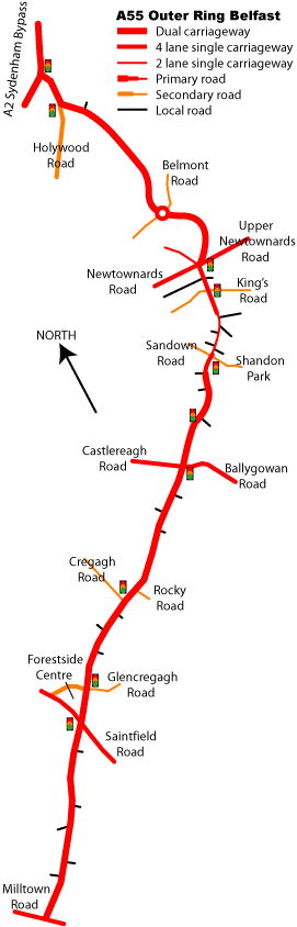
This map of the eastern part of the A55 as it
was in 2005 shows the 2-lane single-carriageway
section at Knock.
Photos
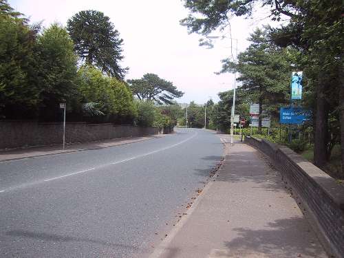
The two-lane section of
the A55 at Knock, here seen looking north from
near Kensington Road (north of Shandon Park) in
July 2006. Whichever scheme is chosen, it will
involve widening the road on the right side
here. [Photo by Wesley Johnston]
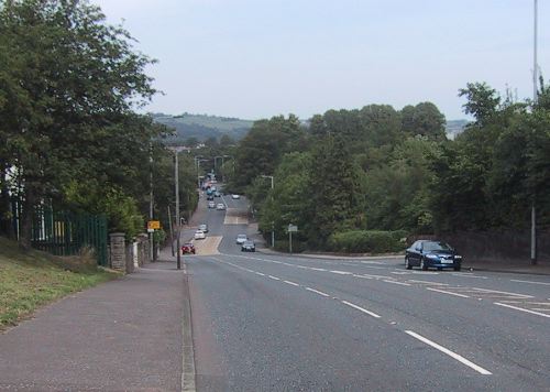
The
existing four-lane single-carriageway section of
the A55 looking north from Knockmount Park in
July 2006. The dip ahead is the traffic light
junction with Sandown Road. Under options B and
C, the road would be widened here. [Photo by
Wesley Johnston]
|
