Where |
The dual portion of the A55 is a bypass of east Belfast from the A2 in the north to Belvoir Park in the south. |
Total Length |
10.5km / 6.5 miles |
Opened |
? |
Cost |
? |
Photos |
See below for photos. |
See Also |
General area map
|
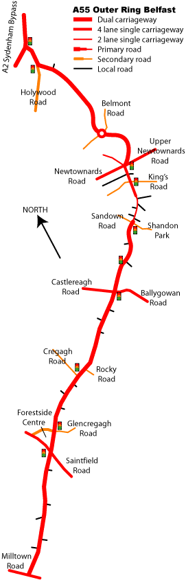
The A55 Outer Ring is almost a full ring road around Belfast that goes from the Antrim Road in north Belfast through west and south Belfast and round to the Sydenham Bypass in the north east. However the quality varies greatly. In west and north Belfast the proximity of the Belfast Hills meant that there was no room to build a new road, so the A55 there is no more than a signposted route round existing streets. The only exception is the dual-carriageway Monagh Bypass, in the Falls Road area, that was built through an area of vacant land. The A55 then continues as a signposted route along Stockman's Lane, Upper Malone Road and Milltown Road past Shaw's Bridge to Belvoir Park. From here the road becomes a much better dual carriageway standard road for almost all the remaining length.
The
map on the right shows the route. With just one roundabout, all other junctions are at-grade and are either standard priority T-junctions or have traffic light controls. This makes the route very slow at peak times with long tailbacks at most traffic lights. However the reason for this is the fact that the road was not purpose built, but is mostly an improved local road.
At the north end the section between the Sydenham Bypass and the Newtownards Road is a fast section, built within the past 20 years through the grounds of a private school. It has almost no T-junctions but does feature the route's only roundabout. From here the road deteriorates badly. The road becomes a slow single-carriageway 4 lane section from the Newtownards Road, with two sets of traffic lights in succession. Then it gets even worse - from here to Shandon Park the road becomes a 2 lane single-carriageway with an S-bend over a steep crest and a 30mph speed limit. This is entirely due to the close proximity of existing housing here. Plans are in the pipeline to widen this section to 4 lane single-carriageway.
After this the road reverts to dual carriageway for its busiest section past the Castlereagh Road, Cregagh Road and Saintfield Road. All of these feed large and growing suburbs and are in fact the main purpose of the A55. It also passes the enormous Forestside Shopping Centre. This whole section is an upgrade of the existing Knockbreda Road which explains the sheer number of side roads permitted to serve existing housing. In parts the road goes along the side of the Castlereagh Hills so the lanes are on a split level with a retaining wall.
Finally, from Saintfield Road to Milltown Road there is a fairly good stretch of dual carriageway with few junctions. Plans from the 1960s to continue the A55 through Lagan Valley Regional Park to the M1 at Black's Road were later modified to connect to the M1 closer to Lisburn. Both plans were shelved, so the A55 therefore dumps traffic somewhat awkwardly onto Milltown Road at Belvoir via what is very obviously an unfinished grade separated junction. |
 |
Future Upgrades?
The main problem with
congestion on the Outer Ring is the sheer number of traffic light controlled junctions. These are all necessary, since it is these side roads that the Outer Ring is designed to serve! The number of side roads and proximity to housing makes any suggestion of making the A55 into an urban motorway impossibly unlikely. Thus the only way to speed up the road is to introduce smaller scale gra
de separation. The simplest form of grade separation is to build either a 2-lane or 4-lane flyover over the existing junction. In several cases this should not be difficult at all within the existing road width, the main problem probably being getting planning permission for large flyovers. For this reason, underpasses might be preferable.
The northernmost and southernmost ends of the road suffer from relatively little congestion so probably do not need any work at this stage. However the middle section from Newtownards Road to Saintfield Road does need work. Three strategic flyovers/underpasses would be best sited at the Upper Newtownards Road, the Castlereagh Road and the Saintfield Road junctions, and possibly also at Cregagh Road. Access to local roads that join the Outer Ring close to these flyovers would need to be resolved. Also, there is a plan to divert the upper Saintfield Road about 1.5km to the south, away from the Forestside Centre, to ease congestion here. This new junction onto the Outer Ring MUST be grade separated. Anything short of this would be extremely short sighted and would be lambasted by future generations.
The only definite plan is to widen the 2-lane single-carriageway section at Shandon Park to 4-lane single-carriageway. See future schemes.
Photos
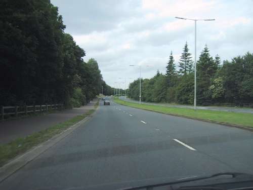
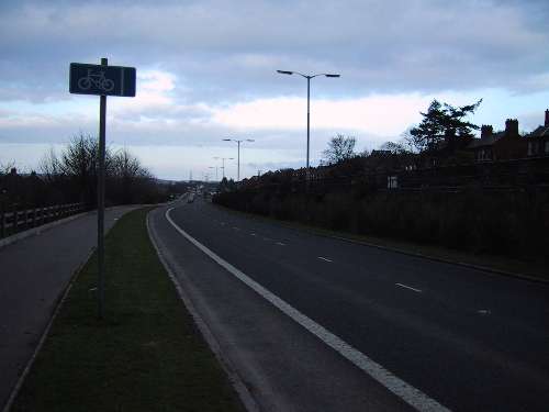
The A55 near Belvoir Park forest, here looking north east (ie south of Saintfield Road). [Photo by Wesley Johnston]
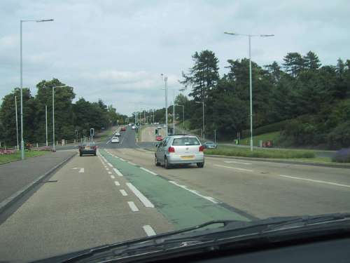
Approaching the Cregagh Road junction on the A55 from the south. The lie of the land here makes this junction ripe for the easy addition of a flyover. [Photo by Wesley Johnston]
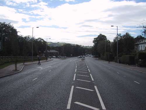
The short single-carriageway section of the A55 near the Upper Newtownards Road. Looking south. [Photo by Wesley Johnston]
Looking north east along the northbound lane of the A55 Outer Ring at Glenburn (between Castlereagh Road and Cregagh Road). The southbound lanes are above the retaining wall on the right. [Photo by Wesley Johnston]
|
