Where |
Links the A4 road west of Dungannon to the M1 motorway to the east. The eastern part of it is dual-carriageway. |
Total Length |
1.8km / 1.1 miles (dual portion) |
Opened |
October 1980 |
Cost |
? |
Photos |
Historic photo - see below.
None of modern road - please e-mail me if you have any. |
See Also |
A4 dualling scheme - on this site
General area map
|
The A4 begins at the western end of the M1 motorway and goes towards Enniskillen. This was not always the case, however. When the M1 was first built it ended at the A29 on the eastern edge of the town. Motorists heading west left the M1 and travelled through Dungannon town centre before joining the A4 that went out of the town along a very twisty road through Granville.
There was always the intention of connecting the M1 to the A4 around the south side of Dungannon. So certain were the engineers who opened this section of the M1 in 1967 thay they just carried on building, and completed another mile of motorway-standard road into the middle of the countryside - where it stopped dead. The section was disused for about 15 years. A photo taken during this period can be seen below.
The Dungannon Bypass was completed in 1980 and made the link to the A4 - the map linked to above shows the arrangement well. Because part of the road had been built in 1967, the first mile of the A4 Dungannon Bypass is dual-carriageway which narrows to single half way along. The remaining 6.5km (4 miles) is currently single carriageway. This is due to be upgraded to dual-carriageway beginning in 2007.
People I know who remember the old road spoke of how awful it was approaching Dungannon from the west and how much quicker the bypass was!
With thanks to Dermot McNally for narrowing down the possible construction dates.
Historic Photo
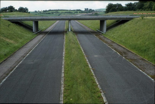
The site of the future Dungannon Bypass, here seen looking west from the end of the M1 at junction 15 near Dungannon in 1980. About a mile of dual-carriageway was built beyond the end of the M1 and this was later incorporated into the Bypass and explains why the first mile of the route is dual. [Photo by Aubrey Dale]
|
