The A1 road is a vital route connecting Belfast and Dublin as well as other cities such as Lisburn and Newry. The A1 was already dual-carriageway as far as Loughbrickland (details) following a scheme to dual the portion from Loughbrickland to Beech Hill (details). The road was then single-carriageway from Beech Hill, and round the existing Newry Bypass. On the south side of Newry a dual-carriageway linked from there to the Irish M1 and hence on to Dublin.
This scheme saw the route around Newry dualled to "high quality dual-carriageway" (HQDC) standard which means full grade separation, with a total of five junctions. A HQDC is one designed to motorway standard, but classed as an A-class road. North of Bessbrook it follows a new cross-country route, while the section to the west and southwest of Newry roughly follows the line of the original bypass. See links above for a map of the route, but see also the strip map below.
This map shows that the road is planned to have five grade-separated junctions, spaced approximately 2km apart. These will be at:
- Sheepbridge - where it leaves the existing A1 north of Newry, on the existing dual section.
- Carnbane - sited between the A27 and A28 to serve both roads.
- Camlough Road - the A25. This is where the route re-joins the existing A1 route.
- Chancellor's Road - half way up the long hill.
- Cloghogue - currently the roundabout at the top of the hill south of Newry.
Strip Junction Map
|
NORTH
Begins as standard A1 north of Newry
2+2 lanes
|
SHEEPBRIDGE
|
|
|
Existing A1
A28 Belfast Road
to Newry (Original A1) |
|
3.2 km / 2.0 miles - 2+2 lanes |
CARNBANE
|
Armagh Road
. |
|
.
Link to Tandragee Road
Armagh Road |
| |
1.7 km / 1.1 miles - 2+2 lanes |
| CAMLOUGH ROAD |
|
|
A27 (Original
Newry Bypass)
Camlough Road |
|
2.0 km / 1.3 miles - 2+2 lanes |
CHANCELLOR'S ROAD |
New access road
|
|
Chancellor's Road
|
| |
2.1 km / 1.3 miles - 2+2 lanes |
| CLOGHOGUE |
.
Forkhill Road
lane drop*
|
|
.
Dublin Road
(to Newry)
lane gain* |
| |
1.6 km / 1.0 miles - 3+3 lanes |
ELLISHOLDING ROAD
(opened Aug 2007) |
lane gain*
Ellisholding Road
(to Meigh)
.
|
|
lane drop*
Dublin Road
(Former A1)
. |
| |
3.1 km / 1.9 miles - 2+2 lanes
|
| |
REPUBLIC OF IRELAND BORDER
SOUTH
Continues as N1 and then M1 to Dublin |
*lane gain: where a sliproad continues as a new lane instead of merging with an existing lane.
lane drop:
where one of the road's lanes becomes the off-slip to a junction.
Progress
29 Jul 2010: As anticipated, the road was officially opened this morning by 'Roads' Minister Conor Murphy, Deputy First Minister Martin McGuinness, Junior Minister Robin Newtown and Irish Taoiseach Brian Cowen (see pic below). Traffic was allowed onto the new road progressively, being completely open by mid afternoon. The opening is very historic in that it now means that there is continuous dual-carriageway or motorway between Belfast and Dublin for the first time in history. That completion came in July 2010, around five months ahead of the schedule publicised back in early 2008, is doubly excellent news. Mr Murphy said "This project is the final link on the key strategic route between Belfast and Dublin on Ireland’s Eastern Seaboard and makes a substantial positive contribution to the social and economic well-being of our communities both north and south." The press release gives further information the effort that went into the scheme: "The scheme involved substantial rock cuttings with 1.2 million tonnes of rock excavated to make way for the new dual carriageway. In line with current good construction practice all of this material was processed on site and used in the construction of the new road. Over two million man hours were successfully worked on the project, which employed 500 people at the peak of the scheme." Well done to all involved in this magnificent scheme which will dramatically improve the experience of motorists in both Newry and the entire eastern seaboard.
- You can see a BBC interview with one of the construction workers here.
- Two separate videos on the scheme are on the UTV site here.
- There are some nice aerial shots of the completed roads on the BBC site here.
- BBC Newsline covered the opening here (starting at 12:14). Available for next 24 hours only.
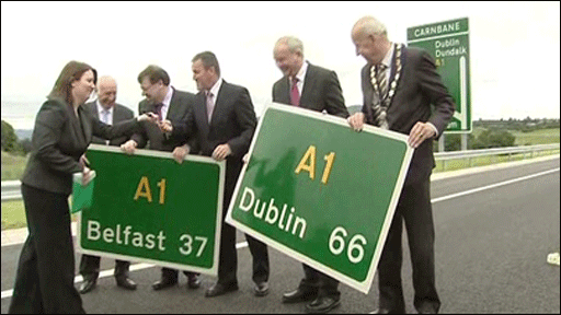
Exchanging road signs between representatives from Belfast and Dublin at the opening on 29 July 2010.
[Picture taken from the BBC web site here.]
26 Jul 2010: Since I posted yesterday's update I have had a flurry of people contacting me to say that the road will be opened to traffic on Thursday 29th July, and this seems to be official information. This suggests that the problems near Sheepbridge have been resolved. This will be marvellous news for the travelling public, especially as this is several months ahead of schedule.
25 Jul 2010: I'm posting this update to answer a question I am getting asked a lot - when will the road open?! Although site visitors e-mail me about all the schemes on the site, I have never had one that has had as much interest as this one. For example, I am even getting e-mails from people in England who are planning to drive from Dublin to Belfast and want to know when the road will open. Although the road is essentially finished now, Roads Service have not given a definitive opening date except to say that it will be in "July or August". Some people have asked workers on the site, most of whom seem to expect opening imminently, but the answer is that we don't know exactly. The chances are that it will just open some day in the coming weeks without any fanfare or warning. One major problem that seems to be occurring is the subsidence north of Sheepbridge (see update on 10 May) which is apparently still not resolved. One site visitor reported that the road has apparently subsided "two feet". This may well delay opening if it is not resolved quickly.
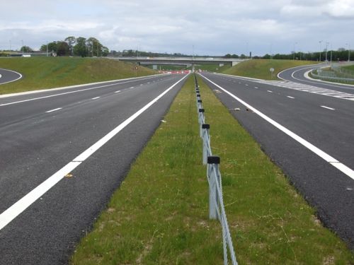
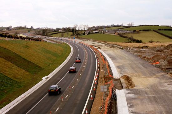
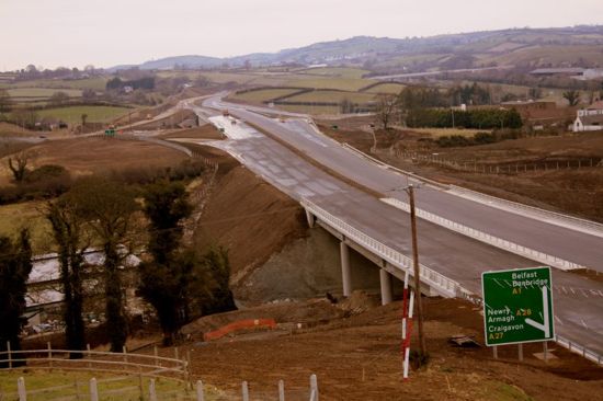
7 Jun 2010: According to a meeting of the Roads Service Board back in April, it is expected that the road will be open during "July or August" this year. To mark the opening it has been decided to hold a Fun Run on the unopened stretch of the A1 on 27th June. The 10km run will go from Camlough Road to Beech Hill and back again and will be in aid of the Southern Area Hospice Services. For more details click here. It has now been confirmed that the northern part of the existing A1 Newry Bypass, from Camlough Road to Belfast Road, will be renumbered as A27 when the works are completed. Meanwhile, site visitor Noel O'Rawe visited the enormous half-opened Sheepbridge junction three weeks ago. Three of his pictures are included below. It is difficult not to be impressed and excited by the sheer quality of this road, a standard not built in Northern Ireland for 30 years.
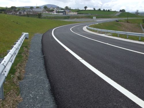
View north along the unopened A1 at Sheepbridge on 16 May 2010. Note the Republic of Ireland style wire barrier, black hard shoulders and lack of central kerbing. [Noel O'Rawe]
The northbound offslip from the A1, as seen on 16 May 2010. [Noel O'Rawe]
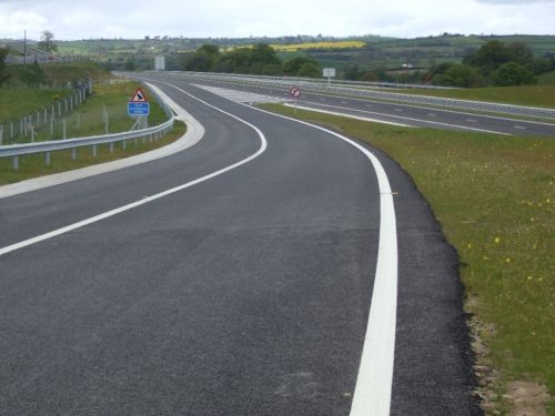
The onslip to the A1 southbound at Sheepbridge on 16 May 2010. [Noel O'Rawe]
10 May 2010: It has emerged that the flooded hole pictured in the previous update (see below) is in fact part of a larger problem that is affecting a section of both carriageways of the new road between Beech Hill and Sheepbridge. The Belfast Telegraph article quotes Roads Service as saying "Monitoring of the new carriageway immediately north of Sheepbridge has identified a localised area of settlement. The location is one where very soft ground conditions existed and substantial volumes of peat were removed. Subsequent investigations indicate that small volumes of soft material still exist below the new carriageway and is the source of the problem. In order to remedy the situation the Construction Company commenced the necessary excavations on Monday April 19 2010 and the work is likely to take up to six weeks to complete." Although it says that it will take six weeks to fix, this is not the same thing as adding six weeks to the project. In all likelhood the repair will take place concurrently with the other work, so the delay to the project might not be as long as six weeks. Completion is still anticipated during the summer 2010.
6 May 2010: Amey Lagan, the contractor on the scheme, has posted up a wonderful series of about 70 aerial pictures that were taken about 5 months ago on their site. Although they are now rather out of date, I am reproducing seven below due to their high quality, arrange north-south. The final photo was sent to me anonymously and shows a flooded hole (perhaps a sinkhole) which opened beneath one of the new carriageways in April.
The A1 at the north end of the scheme near Beech Hill on 11 Dec 2009. [Amey Lagan]
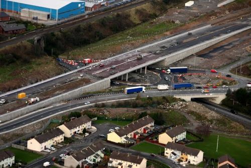
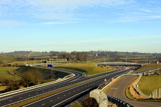
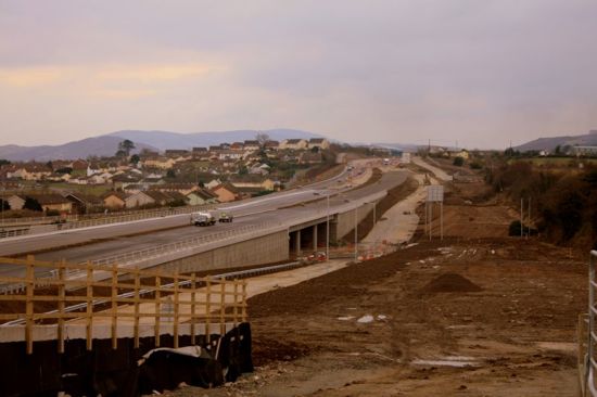
The completed Sheepbridge interchange with the faded former A1 on the right. [Amey Lagan]
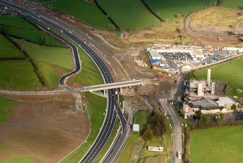
Carnbane Interchange taking shape on 11 Dec 2009. [Amey Lagan]
Camlough Road interchange as it was on 11 Dec 2009. [Amey Lagan]
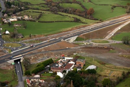
Chancellor's Road - the lowest spec junction on the new road - on 11 Dec 2009. [Amey Lagan]
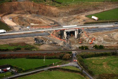
The A1 running through the impressive cutting north of Cloghogue on 11 Dec 2009. [Amey Lagan]
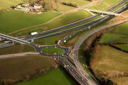
The completed and opened Cloghogue interchange on 11 Dec 2009. [Amey Lagan]
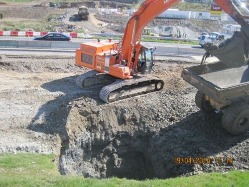
Flooded hole beneath the future carriageway near Beech Hill on 19th April 2010. [Anonymous]
22 Feb 2010: Starting at the north end of the scheme, Sheepbridge junction is now virtually finished, but only partly opened. North of Sheepbridge, ie between there and Beech Hill, work is less advanced with one carriageway still under construction. The road from Sheepbridge to Carnbane is completed, with even the white lines now in place, and is awaiting the rest of the scheme to catch up. Between Carnbane and Camlough Road, construction work is still underway but well advanced. According to site visitor Nowax, traffic was moved onto this stretch today. On the hill section south of Camlough Road, and as far as Cloghogue, only one carriageway is completed, and all A1 traffic is using this carriageway. Finally, the Cloghogue junction has been completed and partially open since Christmas, and is a very impressive scheme. In summary, some stretches are now complete, with the stretches in between less advanced. Completion by the summer certainly seems plausible.
I have included some great photos from two contributors below. Some of the pictures were taken by Nowax about a week ago, while the remaining pictures were provided by the Newsletter, and were also taken about a week ago. My grateful thanks to both of them.
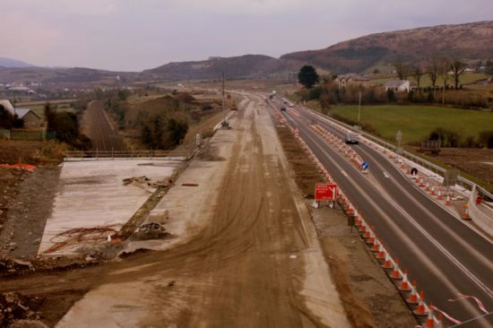
View north from Sheepbridge to Beech Hill, showing the work on the southbound carriageway still underway on 13 Feb 2010. [Nowax]
Looking north towards the completed but not fully opened Sheepbridge interchange. The new A1 on the left is not yet open to traffic. 11 Feb 2010. [Nowax]
View south along the completed but unopened section
of A1 south of Sheepbridge. 11 Feb 2010. [Nowax]
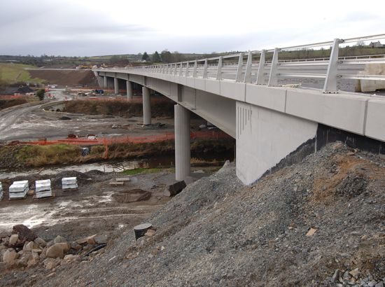
The A1 soaring on its viaduct near Tandragee Road (north of Carnbane). 15 Feb 2010. [Photo by Pat McSorley, courtesy the Newsletter]
Partially completed Carnbane junction, seen looking north on 13 Feb 2010. [Nowax]
Camlough Road junction well advanced on 13 Feb 2010. [Nowax]
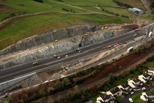
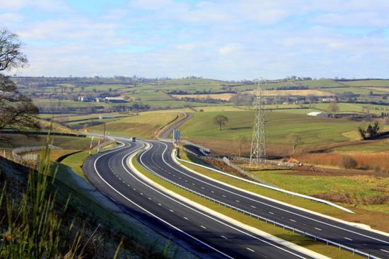
The new A1 as it crosses the railway half-way up the hill section, with still a lot of work to be done. This section is an online upgrade of the existing A1. 13 Feb 2010. [Nowax]
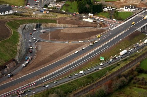
The looped northbound sliproads at Cloghogue junction, open since Christmas, have been literally blasted out of solid rock, seen here on 15 Feb 2010. [Photo by Pat McSorley, courtesy the Newsletter]
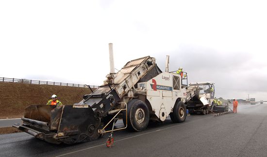
Contractors laying the road surface on part of the A1 on 15 Feb 2010.
[Photo by Pat McSorley, courtesy the Newsletter]
FOR UPDATES BEFORE FEBRUARY 2010 PLEASE VISIT THE ARCHIVE.
Background
This element of the A1 is being privately funded as part of the "DBFO2" (a PPP scheme) which also includes the provision of four grade-separated junctions on the A1, the dualling of the A4 from Ballygawley to Dungannon, and realignments of the A4 at Annaghilla and the A5 at Tullyvar.
Many had thought that the existing Newry Bypass would be dualled since it was itself only completed in 1996. However Roads Service have instead settled on a new route for the northern half of the Bypass which will effectively convert the northern part of the existing Newry Bypass into a local distributor road.
The scheme has attracted considerable local controversy, not least because the fully grade-separated junctions will limit local traffic movements and there is a fear that this will lead to long detours. On the other hand, there are those who see a grade-separated dual-carriageway as too much of a compromise, and want to see a full motorway to match the standard of the route south of the border.
Note on costs
This public consultation in July 2006 gave the cost of the scheme as £109m. However, this press release in February 2008 stated that the cost had risen by an amazing 39% to £152m. This can at least be partly explained by this statement to the Assembly in January 2008, when the Finance Minister stated that he was granting "£22.7million to the Department for Regional Development to meet the increased land costs associated with the A1 Beechhill to Cloghogue scheme and to allow the completion of the Newry / Dundalk scheme." The Regional Strategic Transport Plan estimated the cost of the project at £99.2m, more than the £87m being quoted by the Roads Service in 2005. The scheme is now costing almost double what was estimated just three years before work began.
Photo
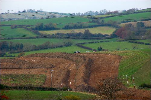
Preliminary site works underway for the new road near Cloghanramer Road, to the north west of Newry in early November 2007. [Photo by Aubrey Dale]
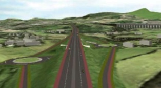
This computer-generated impression of the new route shows the Carnbane interchange looking south, here shown as a dumbbell junction (ie with just one bridge and two roundabouts). It was published in the Roads Service's "On The Move" magazine, issue 6 (Summer 2006).
|


