Westlink Home | Details of the Scheme | Problems and notes | Progress reports
This is a sub-page giving additional information on the Westlink upgrade.
The plans shown on this page are from the Roads Service leaflet "Temporary Traffic Management Strategy" released to the press and hauliers in November 2005. Starting at the western end, the scheme will see the following elements:
- Stockman's Lane roundabout (M1 junction 2) will be signalised to improve capacity. This will occur in January and February 2006.
- The two bridges that carry the M1 over the Stockman's Lane, now nearly 50 years old, will be demolished and replaced with new, wider, bridges. The image below is an artist's impression of the completed junction [From Roads Service public information leaflet, Jan 2006].
- Widening the M1 motorway to three lanes in each direction from Stockman's Lane to its terminus at Broadway (M1 junction 1).
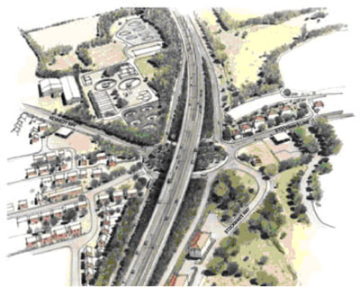
- Excavation of a 7-metre deep underpass at Broadway to allow a dual three lane road to pass beneath. The M1 will thus flow seamlessly onto the A12 here. Sliproads will give access to the Westlink from both directions. The roundabout will be reconstruced on top much the same as it is today and with a solid centre. All current roads here will remain open when work has been completed. The image below is an artist's impression of the completed junction [From Roads Service public information leaflet, Jan 2006]. See also map lower down this page. Work at Broadway will begin in February 2006, but should not affect traffic here for "several months".
- Widening the A12 Westlink to a dual three lane road between Broadway and Grosvenor Road.
- Constructing a new bus lane to the south-east side of the Westlink from the Broadway roundabout to join the existing bus lane at Roden Street.
- Closure of all general accesses to and from Roden Street, and removal of the traffic light junction at this location.
- Provision of a southbound onslip at Roden Street to permit buses only to join the Westlink towards the M1 from the Europa bus centre.
- Access to Mulhouse Road (Royal Victoria Hospital) to be reduced to LILO (left-in, left-out) manoeuvres only. Access will be provided by an eastbound offslip. No access will be provided for traffic coming from the M2 direction who will instead use the entrance at Broadway. Access onto the Westlink out of Mulhouse Road will be provided by an east-facing sliproad (M2 direction). No right-turns will be allowed out of Mulhouse Road (ie M1 direction). See map below.
- Demolition and replacement of the Roden Street footbridge with a more modern structure.
- Construction of a segregated footpath and cycle lane along the Westlink from Broadway to Grosvenor Road.
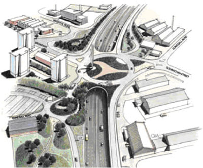
- Excavation of a 4-metre-deep underpass at Grosvenor Road to allow a dual three lane road to pass beneath. The current roundabout will be replaced by a single overbridge to carry Grosvenor Road. Sliproads will be provided to the south ONLY so that traffic will only be able to leave the A12 here from the M1 direction, and only be able to join the A12 towards the M1. The image below is an artist's impression of the completed junction [From Roads Service public information leaflet, Jan 2006]. See also map lower down this page. Work here will begin in February 2006, with the initial work being the banning of "some right-turning movements".
- The third lane will terminate as the Divis Street sliproads. The remainder of the Westlink (the canyon section) will remain two lanes in each direction.
Final Layout
This strip map shows what the Westlink will look like once the works are complete and the A12 has been fully grade separated as far as York Street:
|
NORTH
Begins at M2 and M3 junction, BELFAST
.
|
YORK STREET
|
3 lanes to M2 (left)
2 lanes to M3 (right) |
|
3 lanes from M2 and M3
3rd lane shortly merges
|
|
0.6 km / 0.4 miles - 3+2 lanes
|
| CLIFTON STREET |
Lane gain
Clifton Street (out of town)
.
|
|
Clifton Street (city centre) |
| |
0.8 km / 0.5 miles - 2+2 lanes |
| DIVIS STREET |
.
Divis Street (towards Falls)
Lane drop
|
|
.
Divis Street (city centre)
Lane gain |
| |
0.5 km / 0.3 miles - 3+3 lanes |
| GROSVENOR ROAD |
Grosvenor Road (towards Falls) |
|
Grosvenor Road (city centre) |
| |
0.7 km / 0.4 miles - 3+3 lanes |
| MULHOUSE ROAD |
Mulhouse Road
(Royal Victoria Hospital)
|
|
.
To Europa Bus Centre
Segregated bus lane |
| |
0.7 km / 0.5 miles - 3+3 lanes |
| BROADWAY |
|
|
Segregated bus lane
Donegall Road
Glenmachan Street
(Boucher Road) |
| |
Terminates as M1 motorway, BELFAST
SOUTH |
Order of Works
Information publicised in March 2006 suggested the following timescale, with work on the two junctions beginning immediately and the Stockman's Lane bridge replacement following from June 2006. Then, early in 2007 the M1 between Stockman's Lane and Broadway will be widened over the course of a year, after which the Westlink from Broadway to Grosvenor Road will be widened. The whole thing is due to be completed by August 2009.
| 2006 |
2007 |
2008 |
2009 |
| Q1 |
Q2 |
Q3 |
Q4 |
Q1 |
Q2 |
Q3 |
Q4 |
Q1 |
Q2 |
Q3 |
Q4 |
Q1 |
Q2 |
Q3 |
| |
|
|
|
|
Stockman's Lane Bridge Replacement |
|
|
|
|
|
|
|
|
|
|
|
|
|
|
|
|
|
|
|
|
| |
|
|
|
|
|
|
|
|
|
|
|
|
M1 widening J1 to J2 |
|
|
|
|
|
|
|
|
|
|
|
|
|
|
|
|
|
|
|
|
| Broadway Roundabout upgrade |
| |
|
|
|
|
|
|
|
|
|
|
|
|
|
|
|
|
|
|
|
|
|
|
|
|
Westlink widening |
|
|
|
|
|
|
|
|
|
|
|
| Grosvenor Road junction upgrade |
|
|
|
|
|
|
|
|
|
|
|
|
|
|
|
|
|
|
Aerial Photos
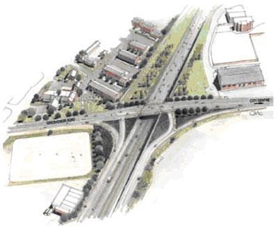
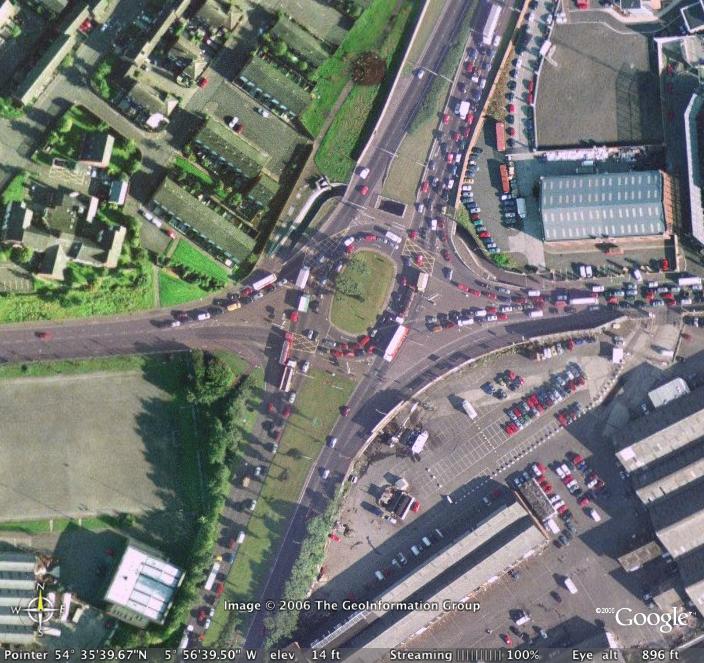
Broadway roundabout as it was prior to work commencing, with the M1 to the bottom and A12 Westlink to the top. [Image from Google Earth]
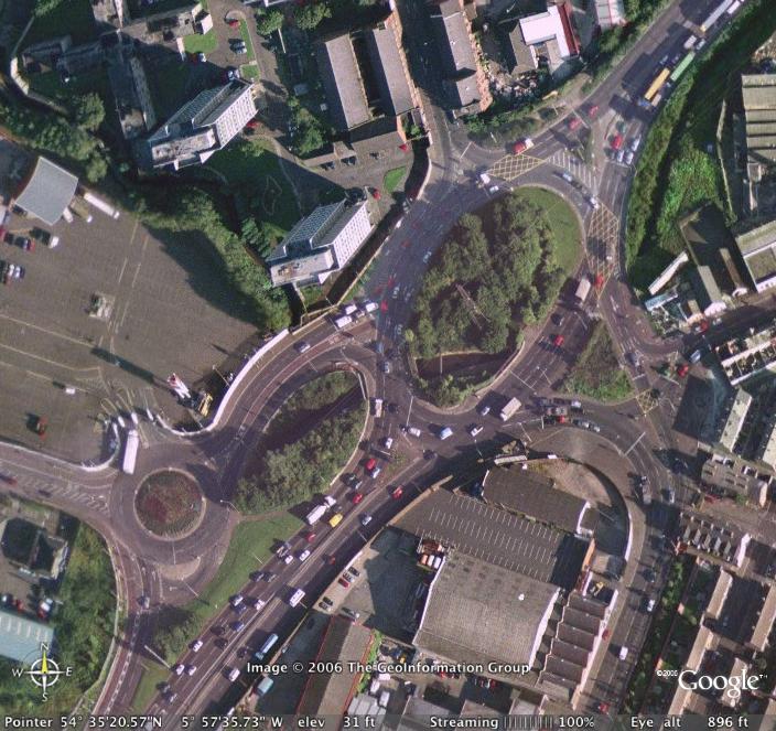
Grosvenor Road roundabout as it was prior to work commencing, with the M1 direction towards the bottom and M2 direction to the top. [Image from Google Earth]
Maps
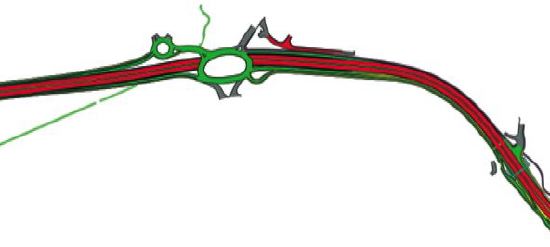
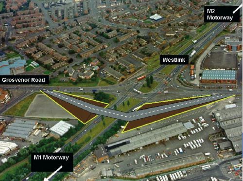
Plan of the new Broadway interchange on the Westlink. The M1 is to the left. The modified Mulhouse Road / Roden Street junction is on the right. The new bus lane is in green running to the south of the Westlink from Broadway towards Roden Street. [From Roads Service leaflet].
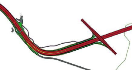
Plan of the new Grosvenor Road bridge on the Westlink. The Westlink heading towards the M2 is on the right. The modified Mulhouse Road / Roden Street junction is on the left. The grey road to the south is the existing bus lane. [From Roads Service leaflet].
From this, it is easy to see why the scheme is going to take three years and £80m to complete. However, once complete it will see a significant improvement to traffic flows on this vital route.
Calls from hauliers and the green lobby for one lane to be set aside exclusively for the use of HGVs seem to have been ignored. The calls to retain the Westlink bus lane from Broadway to Roden Street, on the other hand, have been heeded. The calls to build a segregated cycle lane from Broadway to Grosvenor Road have also resulted in its incorporation into the plan.
Other Photos
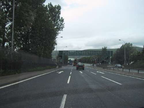
The traffic light-controlled Roden Street junction, seen here, will be removed with left-in and left-out access only provided for Mulhouse Road (Royal Victoria Hospital). [Photo by Wesley Johnston]
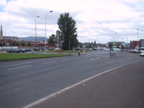
The Grosvenor Road roundabout which will also be grade-separated. The temporary bridge will be constructed roughly where the photographer is standing. [Photo by Wesley Johnston]
A stylised diagram of the temporary Grosvenor Road bridge to be used while excavation of the underpass proceeds. [provided to the press by Roads Service in November 2005]
Will the Westlink be designated a "motorway"?
Probably not, but there is not much to prevent this from happening in the future. A law was passed in 2003 (see here) which gave the upgraded A12 Westlink the legal designation of "special road", which is the legal term for a motorway. This restricts certain types of vehicle from using it. Contrary to popular belief, there are no special rules in terms of build standard that prevent any given road being a motorway. In addition, with the M1 folowing directly onto the Westlink the public are going to see no difference between them. Proposals made by this web site for re-numbering the motorway system (see here) are based on the principal idea that the Westlink should become part of the M1 once the upgrade is completed. Although pedestrians can currently walk on the Westlink and cyclists can use it, these will both be banned once the upgrade is completed. Segregated walk and cycle ways will be provided instead. If the Roads Service have not yet considered this, I would very strongly encourage them to make the Westlink part of the M1.
|


