|
|
Status
|
Construction scheme
(partially completed) |
|
Where
|
To
extend Victoria Road north as far as the
B90 Upper Road |
|
Total
Length
|
0.7 km / 0.5 miles
(of which 0.4 km was built 2019-2023)
|
|
Dates
|
Proposed in Belfast
Metropolitan Area Plan - Nov 2004
250 metres south of
Red Fort Park was build from late 2019
and during 2020 to access a site.
180 metres further south was built
slowly from 2020-2023
Planning permission granted for final
section - Jan 2026
Work likely to start 2026 or 2027 (as of
Jan 2026)
|
|
Cost
|
Unknown - funded by
private developers. |
|
See
Also
|
General area
map
Carrickfergus
Spine Road & Sloefield Road
extensions - proposed schemes
|
Click here
to jump straight down to updates.
Carrickfergus is a large town, predominantly
acting as a dormitory town for Belfast. Due to
the gently sloping terrain, the town's suburbs
have developed as a grid with three east-west
arteries and several north-south arteries. One
of the north-south arteries is Victoria Road.
However, Victoria Road only extends half of the
way (from the A2 at the shore to Prince Andrew
Way). This scheme is intended to see Victoria
Road extended northwards to meet the B90 (known
locally as the Upper Road) as shown in red on
this map (blue shows existing parts of the
road). Of this section, 420 metres was built by
a private developer between 2019 and 2023 for
the Bashford Park development. At the time of
writing, June 2024, only the final 320 metres is
unbuilt.
The proposal is contained in the draft Belfast
Metropolitan Area Plan of 2004 (proposal CS
13/02) and is identified as a developer-led
scheme. This means that Roads Service will not
fund the scheme - it must instead be provided by
housing developers as a condition of planning
permission. About three quarters of the farmland
beside the proposed route is zoned for housing.
Updates
27 Jan 2026:
The BBC
reported two weeks ago that planning
permission has been granted for a large
development of 403 homes in Carrickergus, near
Ulidia College. From a roads perspective, the
development requires the completion of Victoria
Road, since the housing will be accessed
entirely from it (via two T-junctions). So I
think we will see Victoria Road completed in the
very near future, with work possibly getting
underway in the next year, though the developer
has given no indication of a timescale, except
that the entire development is to be completed
by 2033. When completed it will provide another
route for traffic to move between Prince Andrew
Way and the upper road (B90 Marshallstown Road).
The diagram below is from the Planning Service
web site and shows the layout of the
development, with the new section of Victoria
Road visible on the right. The developer will
also upgrade the nearby Prince Andrew Way /
North Road junction as part of the works.
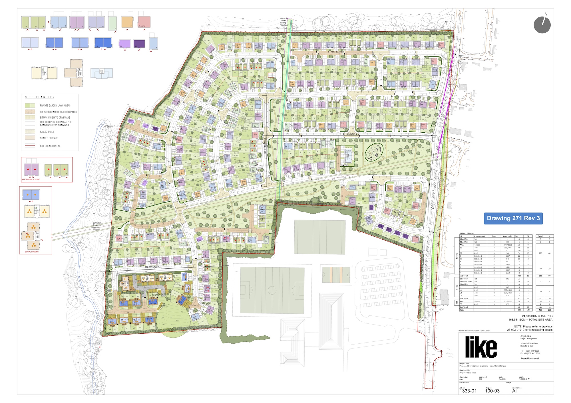
Diagram of the proposed development, as of Jan
2026, with the final stretch of Victoria Road
running along the right hand side of the site.
Click to expand.
19 Jun 2024: I have not updated this
page in the 14 years since I created it and,
truth be told, I had forgotten I had created it.
So this update is to cover the changes that took
place since 2010. In 2019 a private developer
began work on the Bashford Park housing
development. This necessitated the construction
of 250 metres of the new road, south of Red Fort
Park, to access the site. The road was built
over the course of a year from 2019-20. The
developer then built the houses and the road was
slowly extended further south from 2020 until
2023 where it reached a new temporary terminus
after 180 further metres. This leaves a 320
metre section of the site - stretching from
Bashford Park to Ulidia College - unbuilt. This
will not be built by the developer as it was not
a condition of planning approval and it's not
clear who WOULD fund it, as there are no further
plans to build houses along the route and DFI
policy is not to provide non-strategic roads at
public expense, as recently confirmed
by the Minister. So this may be where the story
ends for now!
Photos
You can see two
incomplete 'stubs' at each end of the proposed
road which have been provided by developers in
anticipation of its construction:
|
