|
|
Status
|
Construction scheme
(completed)
Contractor: Fox Contracts
|
|
Scheme
|
New
single-carriageway link road connecting
the B48 Derry Road, Omagh (close to A5
junction) to U1526 Strathroy Road. |
|
Total
Length
|
0.91 km / 0.57
miles |
|
Dates
|
Late 1980s - Included
in 1987-2002 Omagh Area Plan
2007 - Included in Sub-Regional
Transport Plan 2015
July 2010 - Outline planning permission
granted for Phase 1
20 June 2013 -
Planning permission granted for whole
road
26 Feb 2014 - Before
this date, Dept of Education agreed to
fund the road
Early 2015 - Vesting Order to be
published (but not seen as of Oct 2015)
22 Jul 2016 -
Tendering process began
2 Jun 2017 - Tender
awarded to Fox Contracts
Construction anticipated to last 15
months (as of Nov 2016)
9 Nov 2019 - Road
opened to traffic
Estimated completion changed from
"early 2019" as of Feb 2018; and
"autumn 2018" as of Jun 2017)
|
|
Cost
|
£7m, of which Dept of
Education is providing £6m (as of June
2014)
|
|
See
Also
|
Opportunity
Omagh - web site of developer
Maps of scheme - Planning
Service (click "Associated Documents")
|
Click here to jump
straight down to updates for this scheme.
The draft
Sub-Regional Transport Plan (SRTP) of 2006
included a proposed "ring road" round the north
of the town, connecting the various arterial
routes - starting on Derry Road, crossing
Strathroy Road and Gortin Road and terminating
on Old Mountfield Road at Killyclogher. By the
time the final plan was published in 2007,
however, most of this proposal had been quietly
deleted, with only the Derry Road to Strathroy
Road link included. This page relates to this
proposal. The approximate route of this road
link is shown on the map below:
View Strathroy
Link Road, Omagh (proposal) in a larger
map
The
route will be built to 7.3 metre two-lane
single-carriageway standard, ie one lane each
way separated by a white line. At the
south-western end the road will link to the
existing Derry Road via a new roundabout,
adjacent to the existing roundabout. At the
north-eastern end it will meet Strathroy via a
simple "Give Way" T-junction. It will feature a
significant bridge over the River Strule, which
DRD documents indicate will be a three span
structure with a total length of 88 metres. The
road will also feature footpaths on both sides,
with the southern one also accommodating a cycle
path.
The new
link will greatly reduce the severance effect of
the River Strule - currently there is almost no
interaction between the communities on the two
banks of the river. The nearest bridge is a
footbridge 1km away, while the nearest road
crossing is at Sedan Avenue, in the town centre.
This road link will encourage greater economic
and social cohension.
With
thanks to John Campbell of the BBC for
alerting me to some of this information.
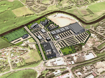
Phases
The scheme was originally being taken forward
by a private developer who is planning a
large commercial site called Opportunity
Omagh on the Derry Road. This
developer was to have been required to build
half of the Strathroy Link Road as a condition
of planning permission. The scheme had therefore
been divided into two phases:
- The stretch from Derry Road to the edge of
the river, including the new roundabout.
- Bridge over the river, and the stretch from
there to Strathroy Road.
The image below, from the WDR&RT
Taggart web site, shows the proposed
Opportunity Omagh development along with Phase 1
of the Strathroy Link Road. However, the scheme
had not yet gone ahead by the time it was
decided that the road would be needed to give
access to the shared education campus at
Lisanelly, initially due to open in 2018, so now
the whole road is being built at taxpayers'
expense.
Updates
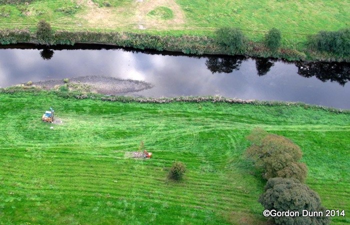
9 Nov 2019: The Strathroy Link Road was
opened to traffic on Friday evening, 9 November,
after a bit more than two years of work. Well
done to all involved, especially Fox Contracts
who did the construction! Below are three photos
that were shared by DFI. All three are of the
new bridge over the Strule, so that must be
their favourite bit! You can also see a short
video of the road shared by a local councillor here.
Civil engineering enthusiast Ian Linton also
shared some photos which you can see by clicking
here.
A pedestrian crossing at the Derry Road end has
still to be activated, but otherwise the scheme
seems largely completed. I have not examined all
the signage on the scheme, but it's not clear to
me what classification the new road has been
given. I would expect a B-number. Fermanagh
& Omagh District Council will need to select
a name for the new road (and they or DFI may
also name the bridge).
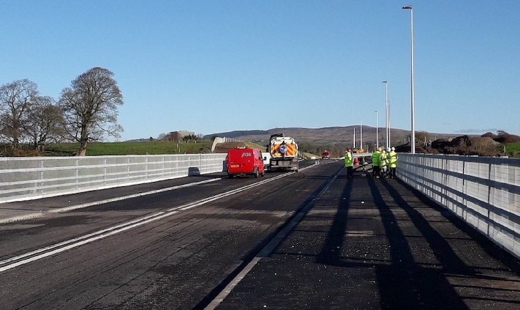
Pic 1: View north-east along the Strathroy Link
Road, looking along the new bridge over the
Strule. The road has one traffic lane in each
direction plus footways on either side, and
sports double "no overtaking" lines in the
centre. 8 Nov 2019. [DFI image]
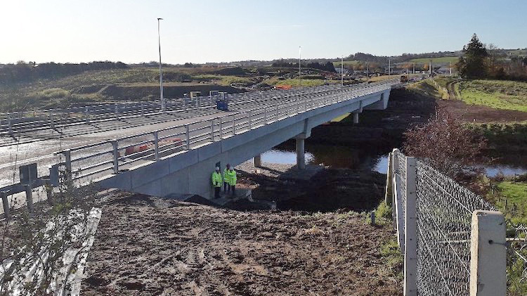
Pic 2: Another view of the elegany new bridge
over the Strule. It features three spans - one
over the river itself and two to cross over the
riverbanks which are submerged when the river is
in flood. The slenderness of the columns shows
how advanced civil engineering has now become. 8
Nov 2019. [DFI image]
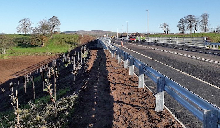
Pic 3: Third view of the new bridge over the
Strule, showing a standard steel safety barrier,
plus the ubiquitous "native planting" that DFI
put along all new roads these days. 8 Nov 2019.
[DFI image]
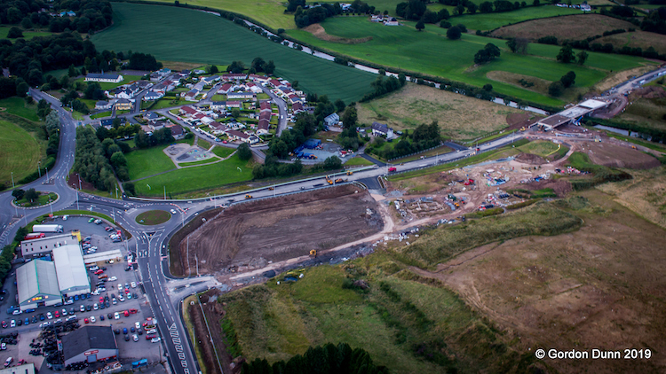
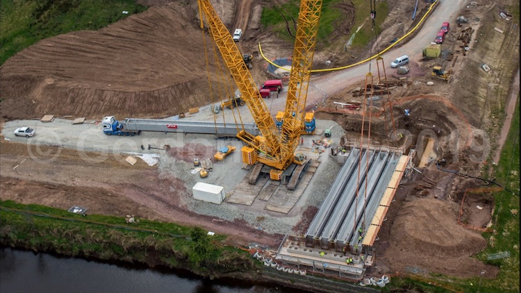
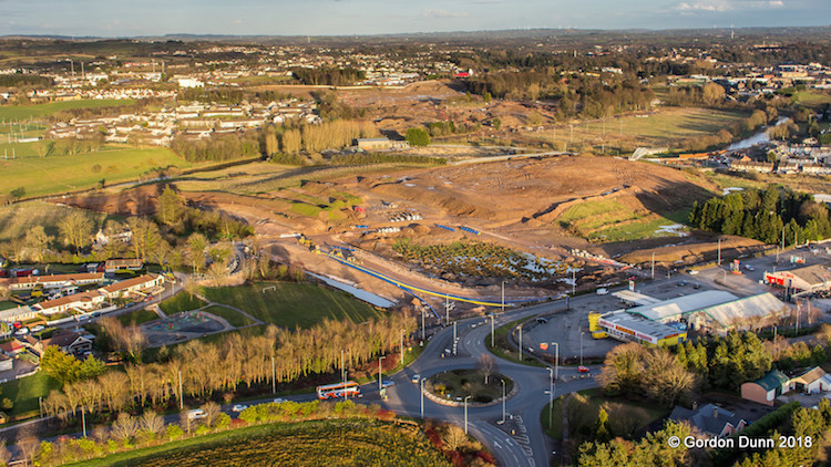
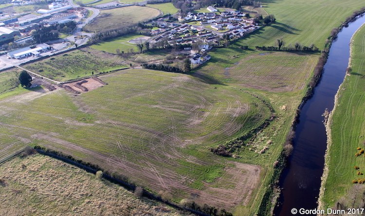
21 Sep 2019: This scheme continues to
progress at a sedate pace - it's now been over
two years since the contract was awarded. Gordon
Dunn, who is sharing images of the scheme on his
Flickr album, took some more last week and
they show the progress as of then. I share two
of the photos below. The most obvious
development is that the bridge deck on the new
Strule crossing appears to now be complete. The
road itself is well advanced on both sides of
the river, with just the bit over the new bridge
to be completed. It's still possible that the
road could be open before the end of 2019,
though it could drift into 2020. The local
council will, at some point, need to choose a
name for both the road and the bridge. Perhaps
it would be an opportunity to memorialise a past
local personality.
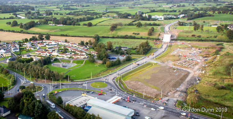
Pic 1: The Strathroy Link road seen looking
north on 13 Sep 2019, with Derry Road in the
foreground. The new bridge over the Strule is
clearly evident. [Gordon Dunn]
Pic 2: Closeup of the new Strule bridge with its
deck completed on 13 Sep 2019. The parapets
still look to be temporary, so that work has yet
to be carried out. The terminus on Derry Road is
visible on the left distance. Note the river and
banks themselves have been undisturbed - the
environmental rules around working in
watercourses are extremely strict these days.
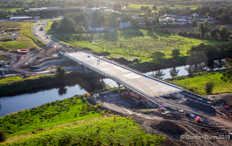
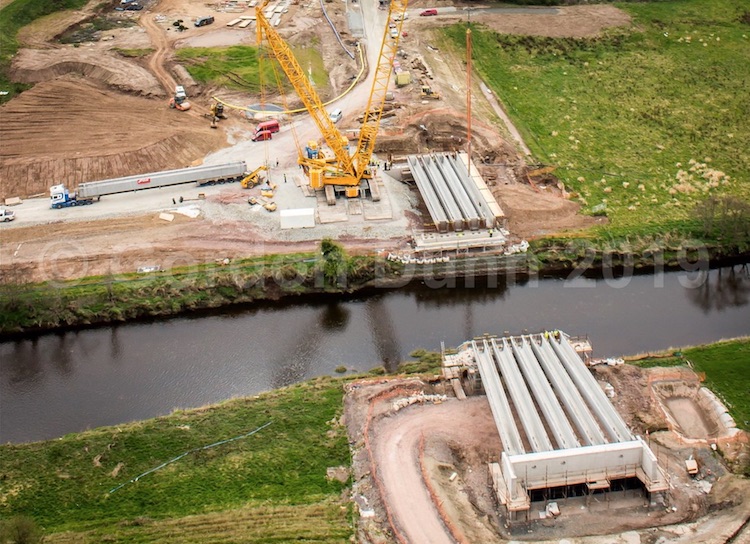
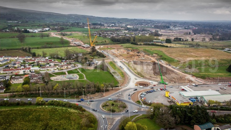
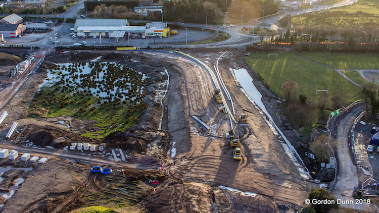
23 Jul 2019: We are almost two years
into the project, and work seems to be slowly
making headway. The most visible change recently
is that the new roundabout at the south-west end
(Derry Road) end of the scheme is now open and
in use. It is shown in the pucture below, for
which we are again grateful to Gordon Dunn who
is sharing images of the scheme on his
Flickr album. The picture also shows that
work is well underway on construction of the
bridge deck of the Strule river bridge - the
beams for this were lifted into place back in
April. Once the structure of the bridge is
completed, the road itself should be completed
in short order, so hopefully we'll see it open
before the end of the year.
View of the Strathroy Link Road on 18 July, with
the existing A5 roundabout on the extreme left.
The new adjacent roundabout on the Derry Road is
now open to traffic. On the right you can see
the deck of the new Strule bridge well advanced.
[Gordon Dunn]
Closeup of the new Derry Road roundabout (on the
right) and the existing 1990s A5 Omagh Throupass
and roundabout on the left. Note that the new
roundabout appears to be equipped with spiral
lane markings, implying that vehicles emerging
from the Strathroy Link Road will be able to
turn right from the left lane. [Gordon Dunn]
7 Apr 2019: We are now roughly a year
and a half into this scheme, which has seen
significant changes since the last update. The
pictures here are, once again, with thanks to
Gordon Dunn who has given me permission to
include them here. He has a lot more pictures of
the scheme over on his
Flickr album. As well as more progress on
the road itself, including the new roundabout on
the Derry Road, the most significant change was
the addition of at least ten bridge beams for
the new bridge over the Strule which were craned
into place on 29 March. The pictures below that
these were placed on the two approach spans. The
five central beams were almost certainly put in
place on the same day after these pictures were
taken. Last year it as estimated that the road
would be open in "early 2019", but at this point
I would say summer at the earliest.
Pic 1: Crane placing one of five beams for the
westernmost span of the bridge that will carry
Strathroy Link Road over the Strule. Note the
HGV with another beam waiting to be craned into
place. 29 March 2019 [Gordon Dunn]
Pic 2: Wider view of the new Strule river
bridge, showing five beams already in place on
the east side and four on the west, with the
fifth visible on its lorry. The central spans
have still to be added in this photo. 29 March
2019 [Gordon Dunn]
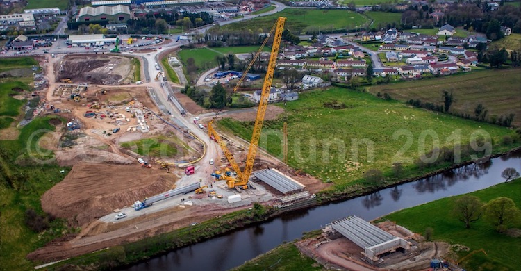
Pic 3: Even wider view of the new bridge with
the Strathroy Link road taking shape beyond,
including the new roundabout on Derry Road. 29
March 2019 [Gordon Dunn]
Pic 4: Final view taken from the Derry Road
junction (foreground) looking east back towards
the new bridge. On the far side of the river you
can see the remainder of the road heading
towards its junction with Strathroy Road, and
the Lisanelly site on the right in the distance.
29 March 2019 [Gordon Dunn] 11 Nov 2018: Work has progressed well
during the summer and autumn. The photos below
were taken by Gordon
Dunn on 6 October 2018 and show that the
road base was in place at both sides, of the
Strule river with the kerbing in place on the
Derry Road side for both the new road and the
new roundabout that will tie it in to Derry
Road. Work on the bridge itself is now underway
with the foundations for both abutments in
place. Work over the winter will presumably
involve building up the abutments before a large
crane arrives on site to swing the beams into
place. The road is due to be open in the spring.
With thanks to Gordon Dunn for these photos and
updates.
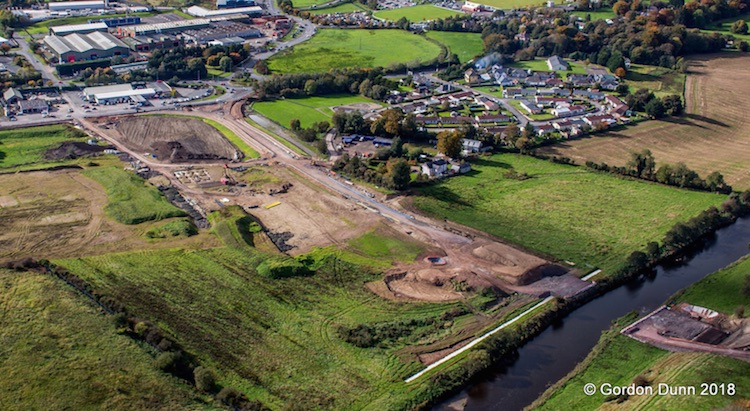
Overview of the new link road on 6 Oct 2018 with
Derry Road at the upper left. [Gordon Dunn]
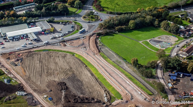
Closeup of the Derry Road tie-in on 6 Oct 2018
shwing kerbing in place for both the new road
and associated roundabout. [Gordon Dunn]
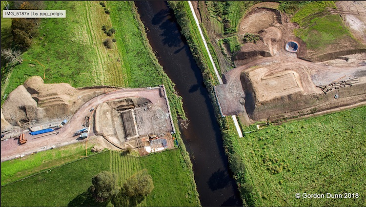
Top-down view of the future bridge on 6 Oct
2018, showin the foundabouts for the bridge
abutments under construction. Modern
environmental restrictions prevent anything
being placed in the water, even temporarily.
[Gordon Dunn] 24 May 2018: Work has been hotting up
over the past couple of months, no doubt aided
by the fantastic weather. This
photo, taken a month ago by Gordon Dunn,
shows that earthworks have now commenced on the
Strathroy side of the river and that the works
on the Derry Road side have now reached the
river too. I would expect to see piling for the
bridge piers getting underway soon, if it is not
already underway. Work has been due to be
completed this autumn, but according to this
news story that has now been pushed back
to "early 2019". The pressure is off in any
case, since work on the shared education campus
it is meant to serve has now been suspended, so
this delay is unlikely cause many issues. In
other news, the tender
for the widening of the B48 Gortin Road in Omagh
to four lanes is now out, with a closing date of
8 June. This scheme is also related to the
shared education campus. I won't create a
separate page for that project, but I will
comment on it on this page as the two are
closely linked. The tender has an estimated
construction value of £2.5m, and will take 12
months to complete.
3 Apr 2018: The amazing flying
photographer Gordon Dunn took some more shots of
this scheme on 24 March and has posted them on
his photo
album on Flickr. I reproduce three of the
photos below with his permission - thank you.
Work has been underway now for 9 months, and at
that rate completion in the autumn would require
a sustained pace from now on. Further comments
are in the captions.
General view of the work site seen looking
north-east on 24 Mar 2018. The new road starts
close to the roundabout and runs towards the top
left, where it will cross the River Strule.
There is no evidence yet of any work beginning
on the bridge structure itself. [Gordon Dunn]
Closeup of the south-western end of the scheme
(same view as previous image but from the
opposite side) on 24 Mar 2018. It shows that
substantial earthworks and drainage are now in
place at this end to allow the road to cross the
floodplain of the Strule. [Gordon Dunn]
Work was also evident at the opposite end of the
scheme, at its terminus on Strathroy Road, on 24
Mar 2018. Work here is less advanced but seems
to involve preliminary earthworks. This location
also seems to require crossing a minor
watercourse, which will probably be achieved by
installing a box culvert. [Gordon Dunn]
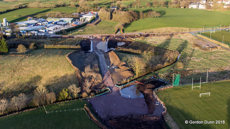
20 Nov 2017: Work is progressing
quietly on this scheme. The photo below was
taken about 8 weeks ago by Gordon Dunn (from his
photo
album on Flickr) and shows work underway
at the western (Derry Road) end which seems to
consist of earth removal and the installation of
rock fill for the road base. At the time these
pictures were taken there was no evidence of
work on the bridge itself, though that may have
changed in the interim.
View south towards the new road
being built on 24 Sep 2017. The existing Derry
Road is on the right, with the new road running
to the left. Note that the bare soil on the left
of the photo isn't part of the road construction
works. [Gordon Dunn]
11 Jun 2017: The contract for
construction of Strathroy Link was finally
awarded on 2 June, to Fox Building &
Engineering (Fox Contracts). Congratulations to
them. So I would expect to see work commencing
sometime in the next few weeks, which should see
the road completed by autumn 2018.
16 May 2017: Gordon Dunn, who takes
aerial photographs, has now created a
photo album on Flickr to record
construction of this road. He added 3 images to
it on 1 May 2017 which show that the vested land
has now been fenced off (click link above to see
the images). This is the land that DFI bought
using a Vesting Order on 8 February this year.
Gordon has said that he will try to take further
images as work progresses. As of today, the
construction contract has still not been awarded
so I don't expect to see any heavy construction
just yet, but we cannot be far off now
(surely?!).
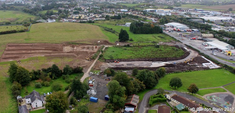
14 Apr 2017: The award of the
construction tender has still not happened - I
inquired and it has emerged that the timescale
has been extended, for quite normal reasons, ie
there's no particular problem with the scheme,
which is good. Tender award should take place
within the next few months. Meanwhile Gordon
Dunn has sent the below image at the end of
March showing the site of the new road. Some
work is evident, though it's not on the line of
the proposed road so it may not be directly
connected. Nonetheless the image is a lovely
overview of how the site looks at the present
moment. The new road will begin at the
roundabout visible in the upper left and then
run to the right along the line evident in the
grass, past the line of trees, and then be
bridged over the river Strule. See the map at
the top of the page for a guide. With thanks to
Gordon Dunn for sharing this image.
Site of the new road seen looking north west in
late March 2017 [Gordon Dunn].
26 Feb 2017: The tender for construction
of this scheme has still not been awarded,
according to the DFI web site but we cannot be
far off. Meanwhile, the DFI "made" the Vesting
Order on 8 February. You can see the Vesting
Order map here.
A Vesting Order is a legal document that compels
landowners to sell the land needed for the road.
It exists in a Draft form for many months to
allow all those affected to respond and make
plans, and eventually is activated, or "made",
which is the point at which title in the land
actually changes hands to the DFI. That is what
has now happened. DFI doesn't normally "make" a
Vesting Order until work is about to commence,
so this shows that work is likely to get
underway soon. So I'd expect to see a contractor
appointed in the near future and work to
commence within weeks.
27 Dec 2016: The tendering process for
this scheme has now been underway for 5 months
but has not yet been awarded. In a Written
Question in the Assembly (AQW 6089/16-21)
the Infrastructure Minister stated that the
intention is to award the tender in February
2017, with a view to beginning work in the
spring. Construction is now estimated to take 15
months, rather than 16, which would mean
completion in the summer of 2017. This is well
in advance of the opening of the completed
Strule education campus in 2020. The Minister
also said that permission has been given to
"make" the Vesting Order (ie, to actually buy
the required land). It's not clear whether this
has actually taken place yet.
Note that provision of the shared education
campus also involves widening a short length of
B48
Mountjoy Road/Gortin Road in Omagh from
two to four lanes each way. I don't intend to
create a separate page for that scheme, but you
can see more
details here.
8 Oct 2016: There is still no sign of
the construction tender being awarded, but we
must be getting close. Last month the
Infrastrucutre Minister was asked about the
scheme via Written
Questions (AQW 3137/16-21, AQW 3135/16-21
and AQW 3133/16-21). The Minister stated that
the scheme would be completed by "mid 2018",
suggesting it might slip beyond the end of the
2017/18 financial year as originally planned.
With construction due to take 16 months,
completion by mid 2018 would require work to be
underway by around February 2017 which seems
plausible. The Minister also gave the estimated
total scheme cost as £7.2m. The Department of
Education is funding the bulk of this, about £6m
with DfI funding the remainder.
7 Aug 2016: The tendering process for
this scheme got underway on 22 July - with the
scheme listed on the "Current
Tenders" page on the DfI web site and the
EU's tenders
list. The construction cost is given as
£6.3m, though note that this is not the total
project cost which also includes things like
land purchase and planning. The "contract
duration" is given as 66 weeks, or just under 16
months, which we can take to mean the time
period from contract award to completion. The
first round of the tender process (the
pre-qualification questionnaire that narrows
down the list of possible contractors) ends on
25 August, after which the next part of the
process will take place. Hypothetically, if
construction were to begin at the end of 2016
then the road would be completed by Spring 2018
which would only just nip it in before the end
of the 2017/18 financial year which is the
deadline for completion (see my comment in the
update for 29 Oct 2015 below where I referred to
"inevitable slippage"!).
1 May 2016: The consultation into the
draft Vesting Order (the document that compels
landowners to sell the land the DRD need to
build the road) took place from 5 January to 5
February. The DRD received just three responses
to this consultation. All the most up-to-date
documents are at the bottom of the relevant
page on the DRD web site, including an
appropriate assessment of the river environment
under the Habitats Directive. It is not clear
what is happening right now - last October a DRD
document indicated that the construction tender
would be advertised in late 2015 and be awarded
by June 2016. However, as far as I can tell, it
has not yet gone out to tender so it looks to be
have been delayed by quite a few months. We will
keep watching to see what happens next. The
scheme does need to be completed by the end of
2017-18 financial year due to the development of
the Lisanelly shared education campus - with a
16 month construction period this would mean
work getting underway by December 2016 at the
latest.
9 Nov 2015: Another update for this
scheme, this time to note that the draft Vesting
Order and accompanying map have just
been published. This details the land that
the DRD intends to buy in order to build the
road. It is being published now in draft form as
it will now go out to consultation (giving
anyone, but principally affected landowners, an
opportunity to object).
29 Oct 2015: The DRD has published their
most
recent procurement plan, and it lists this
scheme which gives us some firm construction
information for the first time. It gives the
construction cost as £5m - though note that this
is not the total project cost, which
also includes planning and land acquisition. It
states that the contract is currently expected
to be advertised in late 2015, and to be awarded
in June 2016 (and with work presumably
commencing quickly after that) with a total
construction period of 16 months. 16 months from
June 2016 takes us to October 2017 which would
certainly be enough time for to meet the DRD's
target of Spring 2018 even allowing for the
inevitable slippage. (The Vesting Order was to
have been published in early 2015 but I have not
seen it - does anyone know anything about this?)
5 Sep 2015: An article appeared about
this road in the Ulster
Herald at the end of July. The main
purpose of the article is to report that the
Department of Education is to fund most of the
cost (ie £6m of the £7m cost) of this road,
although we have known this since June 2014 (see
previous updates below). However it's not clear
if the increasingly dysfunctional nature of the
Stormont Executive will impact on budgets and
hence on this funding. TransportNI has said that
they are aiming to complete the road by Spring
2018, although the article points out that
strictly speaking it doesn't have to be
completed until the shared education campus at
Lisanelly opens in September 2020. The 2018
target date would mean construction getting
underway around mid 2017. A year ago (see
previous update) the DRD anticipated the draft
Vesting Order to acquire the necessary land)
would be published in early 2015, and the Ulster
Herald said this was now expected in summer
2015. However, both these dates have come and
gone and to my knowledge it has not yet been
published.
13 Oct 2014: A geotechnical survey is
now underway on the site of this road and
bridge. The purpose of this work is to find out
exactly what is below the ground so that a more
detailed design can be produced. The picture
below was taken by Gordon Dunn (thank you) and
shows this work underway. The vehicles are being
used to drill boreholes. In a Question
for Written Answer in the Assembly, the
DRD Minister confirmed that this work is
underway, and gave a timescale as follows:
Vesting Order (to acquire the necessary land)
early 2015; Construction in "latter part of
2016/17 financial year" (ie, early 2017);
completion 2018.
Geotechnical survey work
underway on the route of the Strathroy Link Road
on 28 Sep 2014 [Gordon Dunn]
19 June 2014: In the DRD Roads Service report
to Omagh District Council last week, it
was confirmed that Roads Service is committed to
this scheme. Because it must be in place for the
opening of the new shared education campus at
Lisanelly in 2018/19, "Roads Service is
committed to the delivery of this scheme by
the end of the 2017/18 financial year."
This means that we should see the road completed
no later than Spring 2018, which would mean
construction commencing no later than Spring
2017, ie three years from now. Because it is
needed for Lisanelly, the document also confirms
that the Department of Education is funding £6m
out of the £7m cost, with the remaining £1m
presumably being funded by the DRD. The scheme
no longer seems to be associated with the Opportunity
Omagh development.
4 Apr 2014: In the minutes
of a meeting of Omagh District Council on 14
November 2013, it was confirmed that funding has
now been secured in principle. It quotes a DRD
representative as saying that "it was
anticipated that the scheme would commence in
2015/16 through part funding being secured
from the Department of Education in
conjunction with the Lisanelly Shared
Educational Campus scheme and a further £1m
provided by Roads Service." The Department
of Education has an interest in that it is
developing the Lisanelly site for several
schools, and provision of the road would greatly
benefit the scheme. This is then confirmed in
the minutes
of a Transport NI [the newly created body that
oversees Roads Service] meeting on 26 February
2014 which says that they "noted the Minister
for Education has confirmed his Department
will fund the construction and land costs; and
noted the award of a commission to assist with
project development and delivery." There
is no mention of £1m from DRD in this latter
quote, so it's unclear whether this is still the
case or whether the Dept of Education is now
funding it all. But it implies that DRD are now
assisting with the project development, which
would be normal practice as road design is their
skill area, and this will incur some cost. So it
looks as if we could see work getting underway
within the next two years, despite the
uncertainty over the Opportunity Omagh
development. Good news for Omagh.
9 Dec 2013: In the previous
update I was noted that the DRD had applied
separately for planning permission for the whole
of the Strathroy Link Road. This permission was
granted
on 20 June 2013. Since then there has been no
movement as far as I can ascertain. However, if
work has not begun within 5 years the planning
permission will expire and the DRD will need to
apply all over again. There is no further sign
of the Opportunity Omagh development
going ahead either, but it still seems to be a
live proposal. The plan still seems to be that
the private developer will build the first part
(Derry Road to river) and the DRD will build the
bridge and the link to Strathroy Road. So the
two are probably interdependent in terms of
timing.
4 Oct 2012: The Developer of Opportunity
Omagh applied for planning permission for Phase
1 on 9 March 2011 (application K/2011/0156/RM),
and this was granted in full on 7th August 2012.
The DRD applied separately for planning
permission for the entire road on 8th April 2011
(application K/2011/0258/F).
It's not totally clear why the two bodies have
applied separately - it may be the DRD hedging
their bets. No decision has been made on this
latter DRD application. Last
week Tesco withdrew its planning
application to have a store at the site, but
this does not impact on the link road itself.
However, until there is sufficient investment in
place for the developer to go ahead, the link
road will remain on the drawing board.
|