|
|
Status
|
Construction
scheme (completed)
Contractor: Graham Construction; Steel
by Rowecord; planning by AECOM
|
|
Where
|
To
construct a combined foot and cycle
bridge across the River Foyle, in Derry,
from Foyle Embankment (near the
Guildhall) to the Ebrington Barracks
site on the Waterside. |
|
Total
Length
|
Total bridge
structure length approx 312 metres (1024
feet)
of which section over river is approx
235 metres (771 feet) |
|
Dates
|
Oct 2008 - Department for Social
Development gives go-ahead to project
8 Apr 2009 - Wilkinson Eyre Architects
win competition held by Ilex to design
the bridge
25 Aug 2009 - Planning
application submitted
25 Nov 2009 - Planning permission
granted
Jan 2010 -
Construction begins
25 Jun 2011 - Bridge officially opened
|
|
Cost
|
£14.7m (note:
official estimates vary)
Jointly funded by the European Regional
Development Fund's Peace III Programme,
Department for Social Development,
Department of the Environment plus some
local funding.
|
|
Photos
/ Map
|
See below. |
|
See
Also
|
General
area map - Google Maps
|
Derry City is divided
by the River Foyle which has always been a
significant barrier in the city. There are two
other bridges: Craigavon Bridge, which was
completed in 1933 replacing an earlier bridge;
and Foyle Bridge which was completed in 1984 and
forms part of the city's partial ring road. The
Peace Bridge was designed partly to improve
connectivity for pedestrians and cyclists
between the two sections of the city (Waterside
and Cityside) by providing a third bridge
between the two existing bridges. But in
addition, the bridge was also designed to have a
symbolic role since the Waterside and Cityside
are traditionally unionist and nationalist
areas, respectively. This is reflected in its
name. The architect describes the bridge as a
"structural handshake".
The bridge itself is
a suspension bridge with cables supported by two
main pylons 36 metres high. Rather than passing
straight across the river, the bridge has an
unusual S-shape giving it a more meandering
feeling. It is primarily supported by the two
main pylons which are sited in the river itself
and which required 30 steel piles each of which
was 24 metres long and driven 10-11 metres into
the bed of the river. The pylons are at an angle
to the vertical in order to support the curved
bridge. There are then two additional
conventional bridge spans at the eastern end to
allow the bridge structure to cross the railway
line. The total lengths of the various spans
are, from west to east: 63.4m, 96.2m, 63.4m, 37m
and 37m. The bridge comprises approximately 1000
tonnes of steel. The deck varies in width from
3.5m to 4.5m and accommodates two "lanes" - one
for pedestrians and one for cycles. The
construction of the bridge was delayed by the
unusually harsh winter of 2010-11 when there was
snow/ice on the ground for approximately three
weeks, making work almost impossible.
Why is this bridge
on the Northern Ireland Roads Site? I don't
normally list footbridges on this web site. I
have decided to include the Peace Bridge
because (a) it is such a high-profile
and particularly iconic structure and (b)
because of its significant scale and cost.
Photographs
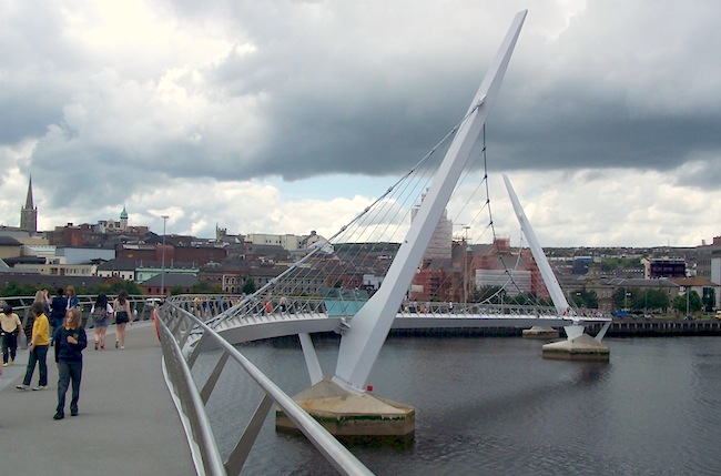
The Peace Bridge viewed looking
west from the Waterside towards the Cityside on
30 June 2011, five days after opening. You can
see the two central pylons and the suspension
cables that support the deck. Note the iconic
S-shape. [Wesley Johnston]
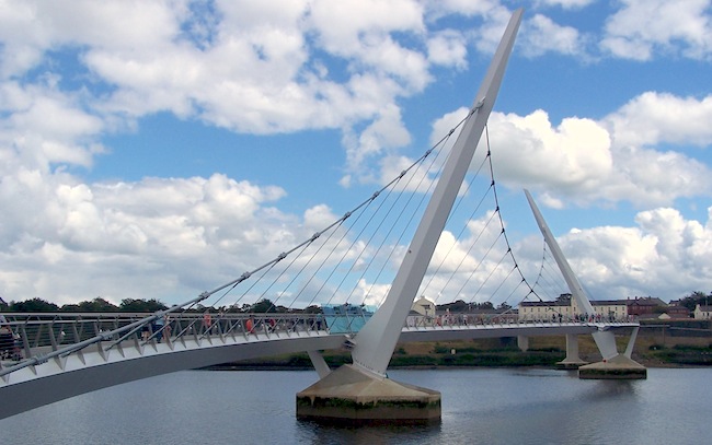
Peace Bridge viewed looking east from the
Cityside towards the Ebrington Barracks site on
the Waterside on 30 June 2011, five days after
opening. Note the two additional piers beyond
the second pylon - these support the two extra
spans that take the bridge over the railway line
which runs along the east bank of the river.
[Wesley Johnston]
|