|
|
Status
|
Construction scheme
(part completed)
Developer - Fraser Homes NI Ltd
|
|
Where
|
To
connect the M2 at j4 (Sandyknowes) to
the Upper Hightown Road |
|
Total
Length
|
1.25 km / 0.78
miles
(of which 0.3 km unbuilt as of Feb 2023)
|
|
Dates
|
Scheme announced by
private developer - Early 2002
Northern 0.86 km
completed - Feb 2003
Formally proposed in Belfast
Metropolitan Transport Plan - Nov 2004
Remains unfinished as
of Feb 2023 - no current plans to
complete
|
|
Cost
|
£0.7m (2005
estimate) - part-funded by private
developers. |
|
See
Also
|
General area
map of Newtownabbey
|
Click here to jump
straight down to updates on this scheme.
North Belfast is connected to Glengormley (part
of Newtownabbey) by the M2. However, there is
another, much older, road link which goes over
the Belfast Hills via Crumlin Road and Upper
Hightown Road. Upper Hightown Road has been
significantly improved over the past 20 years to
the point that it is now (somewhat
optimistically) the signposted route from the
Westlink to Glengormley. Roads Service seem keen
to promote this route in order to reduce traffic
levels on the M2. The problem is that this road
ends in the centre of Glengormley village, an
unsatisfactory arrangement that negates any
advantages the route might have for commuters.
This map shows the route drivers must take in
red:
The Belfast Metropolitan Transport Plan (BMTP)
of 2004 contained a proposal to construct a link
road connecting the Upper Hightown Road directly
to the M2 at Sandyknowes roundabout. This link
is shown in green on the map above. The BMTP
stated that this road would be developer-led, ie
private developers would have to build it in
order to obtain planning permission. The road
would be primarily designed to serve the
developments in the area, but would also help
longer-distance traffic.
Sure enough, at the point the BMTP was
published, permission had already been given for
the Mayfield Garden Village and the developer
had already built the northern 90% of the road
(completed in February 2003) marked in light
green on the map and linking to Sandyknowes
roundabout. The developer did not, however,
build the southern 10% which links it to
Hightown Road and it has therefore ended at a
temporary fence since then.
It's not entirely clear why the road has not
been finished, but it seems a shame that the
road is so close to completion, yet is not
linked up. In the meantime, drivers can still
connect from Upper Hightown Road to the Mayfield
Link Road by rat-running through Mayfield Garden
Village.
Progress
8 Feb 2023: I have not updated this page
for twelve years but here we are! As explained
above, Mayfield Link road was constructed
exactly twenty years ago, opening in February
2003. The final 300 metres connecting it to
Upper Hightown Road was never finished. I have
not heard anything definitive, but I was
recently made aware that the developer of
Mayfield Village has started work on housing
land around the unbuilt stretch, and demolished
a house close to its terminus at the southern
end. It is possible, therefore, that work on the
final stretch of this road might finally be
built! The fact that it has been unfinished for
twenty years is a poor reflection on the
planning process. This sort of thing shoudl not
be allowed to happen. The recently-completed Ballyclare
Western Relief Road shows how this should
be done. With thanks to Gavin Boyle for
information on this.
Photos
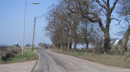
View north-west from close to the end of Upper
Hightown Road. The completed
road will curve through the trees to the right.
29 Mar 2002 [Wesley Johnston]
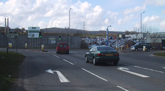
View south from Scullions Road / Mallusk Road
junction on 13 Apr 2002. The new Mayfield Link
Road now continues straight on here, where the
fence was in this image. [Wesley Johnston]
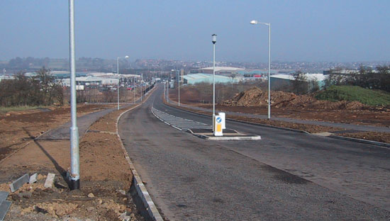
The completed part of Mayfield Link Road, here
seen on 22 Feb 2003
looking north just after opening. [Wesley
Johnston]
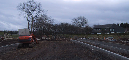
The abrupt southern terminus of the Mayfield
Link Road,
as seen on 9 Mar 2003. [Wesley Johnston]
|
