Status |
Construction scheme (future) |
Where |
To relieve Sandyknowes junction on the M2 by taking traffic off to a new junction. |
Total Length |
Unknown |
Dates |
First proposed - 2004
Construction likely 2015 - 2020 |
Cost |
Unknown
|
Photos |
See map below. |
See Also |
General area map
M2 on this site
A8(M) on this site |
The draft Belfast Metropolitan Transport Plan 2025, published in 2004, recognises that junction 4 on the M2 is a bottleneck and contained a general proposal to redesign the junction to improve traffic flow. Although the details are not specified, it could involve making the A8(M) into a through route.
However, the plan also included provision for a new junction about a mile to the west of the existing junction. It says "The Plan identifies the provision of a new junction on the M2 north of the existing Sandyknowes junction as a means of providing greater capacity at Sandyknowes and reducing or eliminating many of the conflicting movements at the existing roundabout which gives rise to congestion. This scheme is indicated in Figure 6.2. It is considered that this scale of improvement will be required very soon after the end of the 2015 Plan period in order to cater for projected travel demand and to support the full implementation of the Mallusk/ Ballyhenry MEL as identified in the RDS. It is therefore proposed that planning this level of improvement is commenced within the Plan period."
Other than a very generalised diagram that was probably simply indicative, it was unclear what exactly this new junction would look like. However more became clear in February 2006 when the "Plan Amendment Number 1" to the Belfast Metropolitan Area Plan was published. It included a map of the "road protection corridor" for the new junction which, although not giving the road itself, allows one to infer what it would look like (fig 1). Essentially it would have west-facing sliproads only, ie only accessible going to and coming from the Antrim direction. They would join the existing Ballycraigy Road South utilising the existing Ardkeen Bridge (fig 2). A link road would then take traffic east to Corr's Corner or south across the Antrim Road into Mallusk.
This would eliminate the need for west-facing sliproads at Sandyknowes, which would then be free to a more dedicated junction serving Belfast traffic only. It could also mean closing other accesses onto Sandyknowes, such as the country end of the Antrim Road, Scullions Road into Mallusk or Ballyhenry Road. This would allow the existing roundabout to be ripped out and replaced with a more tailored junction such as that which exists on the M1 at Black's Road.
Opposition from residents in the Ballycraigy Road area was evident in this news story on 21 September 2006 (Belfast Telegraph, payment required to view).
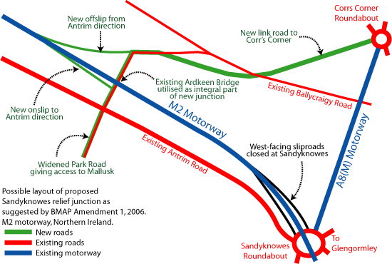
Fig 1 - Possible layout of the new M2 Sandyknowes relief junction
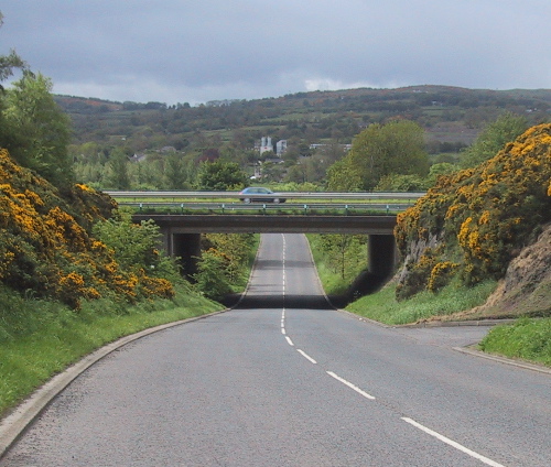
Fig 2 - The existing Ardkeen bridge, here seen looking south, is today simply a rural road but would under this plan become an integral part of the new junction.
|
