|
|
Status
|
Construction scheme
(proposed)
|
|
Scheme
|
New
single-carriageway link road to connect
Hillhall Road to Ballynahinch Road, via
Plantation Road and A49 Saintfield Road. |
|
Total
Length
|
1.9 km / 1.1 miles
|
|
Dates
|
Idea discussed at the
Public Inquiry into the Belfast
Metropolitan Area Plan - 2007
Supported by the
former Lisburn City Council
First public
consultation by developer Gravis
Planning - Jun 2019
Second public
consultation by developer Gravis
Planning - Oct 2020
Schedule for construction unknown (as of
Dec 2020)
|
|
Cost
|
£unknown - funded by
private developers
|
|
See
Also
|
General
area map - Google Maps
|
Click here to jump
straight down to updates for this scheme.
This scheme would see
a new link road constructed round the
south-eastern corner of the Lisburn urban area,
as shown below. While fundamentally designed to
provide access to new residential developments,
from a transport perspective its primary purpose
would be to connect the A49 Saintfield Road west
to Ballynahinch Road and east to the B23
Hillhall Road by providing an alternative to
navigating the congested Saintfield Road
roundabout below the M1 motorway. The most
useful section to longer-distance traffic would
be the short stretch from Saintfield Road to
Ballynahinch Road, as explained below.
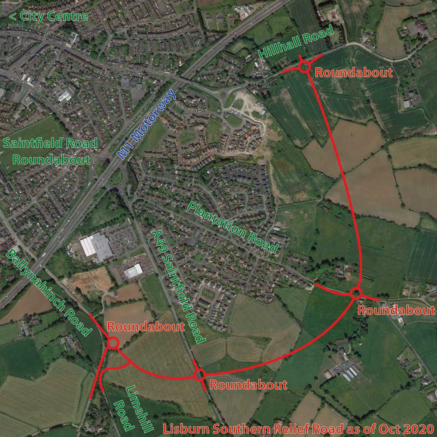
Map of the proposed Lisburn
Southern Relief Road as of Oct 2020 (click to
enlarge).
The developer estimates that,
if built, the new road would reduce traffic on
Saintfield Road by 20%. This, of course, would
happen because traffic heading to Lisburn city
centre and Blaris industrial estate would
likely switch to the Ballynahinch Road using
the new link as it avoids the busy Saintfield
Road roundabout. Traffic, therefore, would
likely increase a good bit on Ballynahinch
Road. The road would also provide a way for
residents of the Saintfield Road and
Plantation Road to get to Hillhall Road
without using the Saintfield Road roundabout.
In 2019 the developer
proposed to build the western part of the road
first (Ballynahinch Road to Plantation Road) and
the extension to Hillhall Road in a later phase.
However, following public feedback, as of 2020
they are now proposing to build the whole road
in one phase. The scheme includes four
roundabouts, plus a short new link road to
connect Limehill Road to the new link. There
would also be priority T-junctions along the
road to give access to the new residential land
on either side. The road would probably be
unclassified or, at most, have a
B-classification.
This scheme was not
an official proposal at the time of the
publication of the Belfast Metropolitan Area
Plan, but at the subsequent Public Inquiry, held
in 2007-08, the idea was mooted by Lisburn City
Council. At that time the Department of the
Environment accepted that the idea had merit but
it wasn't included in the final plan. DFI Roads,
therefore, have no plans to either fund or build
the road. This is in keeping with current
policy, as the proposed road is primarily
designed to serve new housing developments, and
therefore should be privately funded.
Part of Full Lisburn
Orbital?
The developer has
noted that Lisburn already has a northern
orbital road, in the form of the North
Lisburn Feeder Road, as well as a western
orbital in the form the existing Knockmore Road
and the proposed (but unbuilt) Knockmore
Link that would connect it to M1 junction
8, and then the existing A101 to the roundabout
on the A1 at Sprucefield. In theory, an
additional stretch of road (as yet unplanned)
joining the A1 here to Ballynahinch Road could
connect this series of roads to the Lisburn
Southern Relief Road creating an orbital road
around 75% of the city. This is quite an
intriguing idea.
Updates
14 Jun 2021: The developer, Hillmark
Homes, submitted an application for planning
permission to construct the Lisburn Southern
Relief Road on 5 May 2021. The reference is LA05/2021/0499/F.
So that is the ball rolling on this. The
associated documents are not a detailed design,
but give a general idea of what is planned. At
this point it appears to be a conventional two
lane single-carriageway with roundabouts. (This
information was sent to me by a site visitor – I
can't locate the message now so I can't remember
his name, but thank you!)
8 Dec 2020: Gravis
Planning carried out an online public
consultation into the proposed Lisburn Southern
Relief Road in October 2020. The consultation
has now closed, but the material still seems to
be accessible at
this link. This is their second
consultation and the design of the road has been
modified slightly in response to feedback from
the 2019 consultation. It does not appear that
the developer has yet applied for planning
permission to build the houses or the link road
and it is not clear what timescale is proposed.
|
