|
|
Status
|
Construction scheme
(completed) |
|
Where
|
To
complete a new road link between
Killyglen Road and Linn Road in west
Larne, serving new housing developments
at Lindara, Walnut and Blackthorn.
|
|
Total
Length
|
1.1 km / 0.7 miles
|
|
Dates
|
Proposed in "Larne
West Study", DOE - 1992
Included in "Larne Area Plan 2010" -
1998
Work began during or after 2001
Included in
Sub-Regional Transportation Plan (SRTP)
- 2007
Road almost completed - but not linked
at centre - by 2009
Developer Eassda went
into administration - Nov 2009
DRD announce that they will complete the
road using the developer's "Road Bond" -
Jul 2013
DRD complete
the road using the developer's
"Road Bond" - Dec 2013
|
|
Cost
|
Unknown - was
funded by private developer
DRD's work to finish the road in 2013
cost £500,000
|
|
Photos
|
See below for links
|
|
See
Also
|
General
area map of Larne
Larne
West Distributor (South) - on this
site
|
"Larne West" is a term that has been in use
since the early 1990s and refers to the plan to
release large quantities of land for new housing
to the west of the town. Because it was
recognised that such large-scale development
(111 hectares) would require new road
infrastructure, the DOE published the "Larne
West Study" in 1992. This study delineated two
new distributor roads to serve the land. The
first, in the north, would connect Killyglen
Road and Linn Road. The second, in the south,
would connect the first distributor to the main
A8 at Millbrook. This page refers to the first
of these. the map below shows the two roads,
with the northern part in red and the southern
part in blue. The developers of the housing
would be required to fund and build the roads in
their entirety, and once completed to an
appropriate standard they would be "adopted" by
Roads Service who would be responsible for
maintaining them.
The Larne West Study required the road to built
to a particular standard: 7.3m wide with 2m
footpaths and 3.5m verges on either side. There
were also to be no private accesses directly
onto the road. Instead, houses would front onto
side roads which would themselves link to the
distributor road at regular intervals.
Work began some time after 2001 (I have been
unable to determine exactly when) and the road
was largely completed by 2009 when the
developer, Eassda, went
into administration. At that point the
road was severed between the Lindara and
Blackthorn developments by a short incomplete
section of road. The Google Streetview below
shows the view north west from the Lindara side
in August 2011. This pile of earth is all that
prevented it functioning as a through road.
There was then a frustrating four year period of
limbo when Roads Service refused to take
responsibility for the road because it had not
been completed to the standard required, but the
developer was no longer in a position to carry
out the work. The solution finally came in late
2013 when Roads Service used a £500,000 "Road
bond" that the developer had put up some years
before to complete
and finally
open the road. This also involved laying a
new water main along the route.
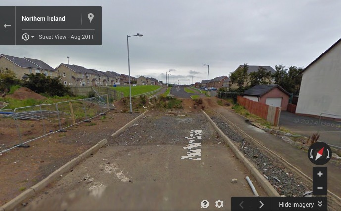
Screenshot from Google Streetview showing the
view north along the road from the Lindara
development. Its continuation in the Blackthorn
development is seen beyond. [ Google
Streetview]
.
.
|
