|
|
Status
|
Construction scheme
(proposed) |
|
Where
|
To
provide a single-carriageway link
between A22 Comber Road and A20
Newtownards Road round the eastern side
of Dundonald. |
|
Total
Length
|
2.0 km / 1.2 miles of
new road
|
|
Dates
|
1969 - Scheme proposed
in Belfast Transportation Plan to
provide a link from the A20 to the M7
motorway
1990 - Scheme included in the Belfast
Urban Area Plan 2000.
2006 - Scheme included in the draft
Belfast Metropolitan Area Plan 2000.
Jun 2019 - Public event to consult on
proposal to construct housing on part of
the route of this road.
|
|
Cost
|
£unknown - to
be funded by private developers
|
|
See
Also
|
General
area map - Google Maps
|
Click
here to jump straight down to updates
for this scheme.
This scheme has been in planning now for half a
century, having been first proposed in the 1969
Belfast Transportation Plan. That was the plan
that proposed a major system of motorways
extending out from the Belfast
Urban Motorway in the centre of the city.
One of these, the M7, would have run along the
route of what is today the Comber Greenway to
Dundonald (formerly a railway line). The
motorway would have travelled over the A22
Comber Road on a bridge to a huge interchange
just south of Ballybeen. This is shown in the
map below. There was an eventual aspiration to
extend the M7 to Newtownwards, but this was
regarded as being on the long finger even at the
time. As a result, a link road was proposed to
connect it to the A20 Newtownards Road. This is
shown on the map below labelled E14 (meaning the
14th road proposal in the "E"ast of the city).
Of course, the M7 never
happened as it was scrapped along with the
rest of the motorway programme when Direct
Rule was imposed in 1972. The scheme did not
die however. A review of transportation was
undertaken in 1987 and it proposed a cut-down
all-purpose A-class road for the route of the
abandoned M7. This would have followed the
route of the M7 as far as the A22 Comber Road
in Dundonald, and thereafter followed the
route of the E14 to the A20 Upper Newtownards
Road. It was known at the time as the "Comber
Route". This is shown in the map below, taken
from the 1990 "Belfast Urban Area Plan 2000".
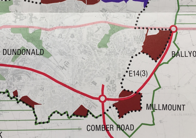
Note that the number "E14" has persevered.
Note also how much development has occurred in
the interim, including construction of the
entire Ballybeen Estate. The connection to the
A20 is at Quarry
Corner, so called because there used to
be a quarry at a 90° curve in the road, which
was obliterated when the dual-carriagway was
built in 1980. At the south end, a realignment
of the Comber Road was proposed with a new
roundabout on the banks of the River Enler.
Still nothing happened, however. The "Comber
Route" was never built, with attention instead
focusing on upgrading the M1/Westlink corridor
and building the M3 Lagan Bridge. Transport
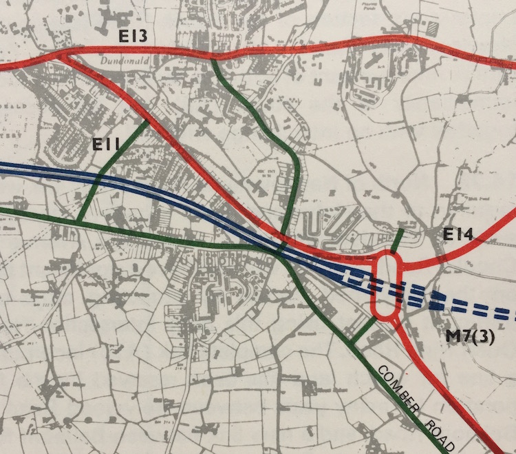
thinking continued to evolve. The draft "Belfast
Metropolitan Area Plan 2015", published in 2006,
suggested a rapid transit system for the city.
This was to run along the line of the "Comber
Route" but be limited to buses rather than
general traffic. Since it would terminate at the
Comber Road it was recognised that traffic from
Newtownards would need a way to reach it. Thus
proposal E14 got a third lease of life as it was
included in the "Belfast Metropolitan Area Plan
2015" as shown below. The new proposal abandoned
the idea of realigning the A22, and instead
proposed a short link between the two. The plan
also allocated a massive tranche of land for
housing (shown in brown) and the plan thus
established a "road protection corridor" to keep
it free of development. This corridor is already
plainly visible in aerial
views of the Old Mill, Cooper's Mill and
Millmount developments. The route changed
slightly to flow directly onto what is today the
Comber Greenway, presumably the idea being that
it would form a continuous route that rapid
transit vehicles could continue onto. It was
also stated in the plan that the road would NOT
be funded by Roads Service but by the developers
of the brown-coloured land. It said "The
Quarry Corner to Comber Road non-strategic
road scheme provides access from the A22
Comber Road to the A20 Upper Newtownards Road
transport corridor and the EWAY Rapid Transit
Scheme – now proposed to be road-based.
Developers will be responsible for funding the
MCH 14/02 either in full or in a substantial
part." The number of the road proposal has
changed to "MCH 14" meaning "Metropolitan
Castlereagh, but the number 14 lives on.
Twelve years have now passed
(as of 2018) since this incarnation was
proposed and rapid transit is now largely
complete, except that the route is actually on
the A20 Upper Newtownards Road. The "Comber
Route" is now a walking/cycling path called
the Comber Greenway and is not now going to
become a route for buses. That leaves the
Quarry Corner Link a little up in the air.
However, with such huge development in
Dundonald the pressure on the village centre
is immense, and this scheme would definitely
serve a growing need to take traffic out of
the centre of Dundonald. The little link road
at the bottom of the above map HAS actually
been built, but the rest of the road is
unbuilt. Despite it being stated in the
Belfast Metropolitan Area Plan that the scheme
would be funded by developers, as far as I can
tell NONE of the planning permissions for the
huge housing areas have actually included
provision of all or part of the road as a
condition. If that continues then the housing
will eventually be completed with a big, grass
line through the middle and no road.
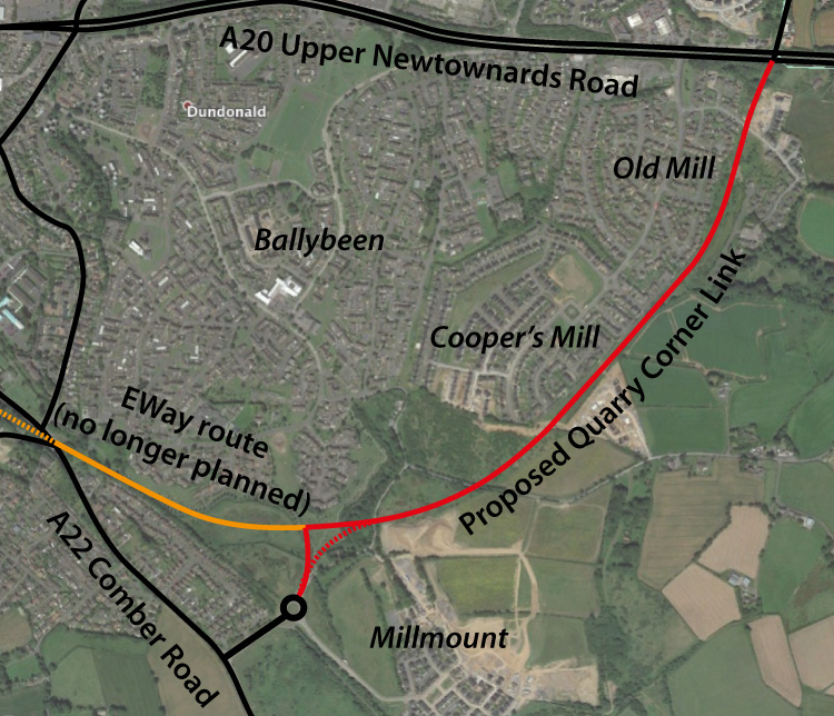
The map below shows the current situation with
the now-abandoned EWay rapid transit route
shown in orange, and the remaining Quarry
Corner Link plan shown red. The layour of the
houses in the area still seems to be being
designed with the ORIGINAL EWay plan in mind,
which to me no longer makes sense as it's no
longer necessary to curve the road west to
meet Old Dundonald Road. I would suggest that
constructing the link road along the dotted
line to join the existing stub link road would
make much more sense. Such an option is,
however, rapidly disappearing as the Millmount
development progresses.
Recommendations
I would therefore urge DFI Roads and Lisburn
and Castlereagh Council to do three things:
- Be aware of the content of the Belfast
Metropolitan Area Plan and its committment
that this road should be funded by
developers of the nearby lands, and not to
miss this opportunity to provide
much-needed infrastructure.
- Re-visit the land protection corridor at
the A22 end with a view to a more direct
tie-in to the A22 in order to prevent
development jeopardising this more
sensible alignment. This would also reduce
the overall cost of the scheme.
- Make provision of components of the road
a condition of planning for future
sections of housing alongside it.
Updates
19 Jul 2023: It is four years ago since
Fraser Homes held a consultation on their
proposal to abandon the road protection corridor
reserved in the current (perpetually "draft")
Belfast Metropolitan Area Plan for the Quarry
Corner Link. Since then I have heard nothing
whatsoever. We know that the councils are
currently working on development plans for local
areas that have not yet been made public, and
that DFI are holding off making wider decisions
until that work is done. So what I expect is
happening is that Fraser Homes have lobbied for
the removal of the road protection corridor, as
suggested in their public consultation in 2019,
but that no final decision has been made. I do
hope that both DFI Roads and the local council
take into consideration the points I made below
when looking at this question.
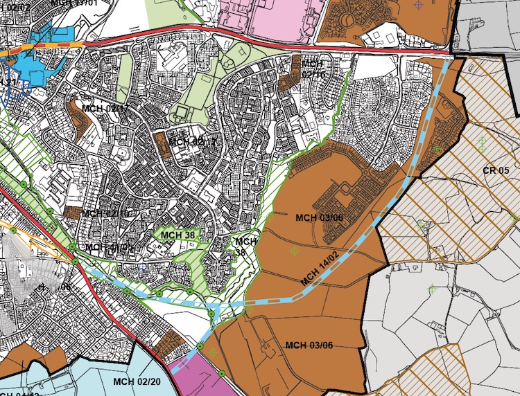
26 Jun 2019: A housing developer, Fraser
Homes, held a public consultation event last
week in Dundonald Library. They are proposing to
construct houses on the northern section of the
corridor reserved for the Quarry Corner Link.
The area in question is shown below, which is
taken from information given out at the public
event. It is currently a proposal, and they have
not yet formally approached the Department for
Infrastructure. Obviously, such work would
prevent construction of the Quarry Corner Link
and by necessity lead to its abandonment, so it
is a decision that needs to be taken at a
strategic level.
At the public event, Fraser Homes made a number
of points in support of their proposal to build
homes on the route of the road:
- The Quarry Corner Link, as it was originally
proposed in the Belfast Metropolitan Area
Plan, was intended to connect the Upper
Newtownards Road to a Park and Ride on the
Comber Road to serve the proposed Rapid
Transit scheme which at that time was to have
used the route of the Comber Greenway. But, in
fact, the park and ride was built at Dunlady
Road, rendering the proposed road redundant.
- Transport consultants employed by Fraser
have concluded that the road would have little
strategic value and would serve no public
transport function.
- There will soon (within the next few years)
be a direct route between Comber Road and the
Upper Newtownards using the
partially-completed spine road that traverses
the Old Mill and Millmount developments, which
will allow through traffic movements and bus
routes. The consultant at the public event
felt that this was appropriate for the spine
road.
- There is an option of routing a cycling
route along the road corridor. Graphics
displayed at the event suggest that this would
take the form of a cycle lane alongside the
roads that serve the new housing, rather than
a stand-alone cycle route like the Comber
Greenway.
These points have some merit. In particular,
the Quarry Corner Link would indeed result in a
second road being built adjacent to what will
soon be a viable through route through Old Mill
and Millmount. However, there are some
additional points that need to be made:
- The Quarry Corner Link was originally
proposed in the 1969 Belfast Transportation
Plan, not 2004 as stated. It has been a purely
road proposal for most of its existence. The
Belfast Metropolitian Area Plan added a public
transport dimension by suggesting that it
could also carry rapid transit. However, BMAP
is clear that the proposal is BOTH a road
proposal AND a public transport proposal ("The
Quarry Corner to Comber Road non-strategic
road scheme provides access from the
A22 Comber Road to the A20 Upper Newtownards
Road transport corridor and the EWAY
Rapid Transit Scheme", emphasis mine).
It therefore does not follow that the decision
to route Glider along the Upper Newtownards
Road renders the Quarry Corner Link proposal
redundant.
- Both the A20 and A22 are strategic roads,
and much of the traffic moving between them is
also strategic in nature. Due to the
significantly over-loaded road network in
Dundonald, much of this traffic is displaced
to three routes – the Ballybeen Estate,
Greengraves Road and Ballyrainey Road. None of
these routes are appropriate for strategic
traffic. The BMAP calls the Quarry Corner Link
a "non-strategic" road scheme, which simply
means that the completed road would not form
part of the strategic road network. However,
the Quarry Corner Link would still serve a
strategic purpose in carrying much of the
traffic between the A20 and A22.
- It is questionable whether a strategy that
actively encourages longer-distance traffic to
drive through a housing development is
sensible, especially given that in some places
there are houses that directly front the spine
road, and given that land has been reserved
for the past fifty years to provide such a
road.
- BMAP
stated that the Quarry Corner Link would be
funded by the developers of the nearby lands.
It says "developers will be responsible for
funding the [Quarry Corner Link] either in
full or in a substantial part". To the
best of my knowledge, none of the developers
of these housing lands have ever had provision
of this road made a condition of planning.
That is a matter for the planning authorities
but it strikes me as a failing of the planning
process over the past 15 years.
- Building on a road protection corridor
effectively removes any possibility of
building such a road for generations to come.
In other areas we have built over transport
corridors, and later come to regret it (eg the
canals, railways and other unbuilt roads).
In any case, this is currently merely a
proposal. The developer is currently gauging
public opinion and has yet to formally approach
DFI with the proposal. DFI will have their own
views of the merit of the idea, as will road
users and residents of the Dundonald area. At
the public event visitors were encouraged to
email any feedback they have to
eway@gravisplanning.com .
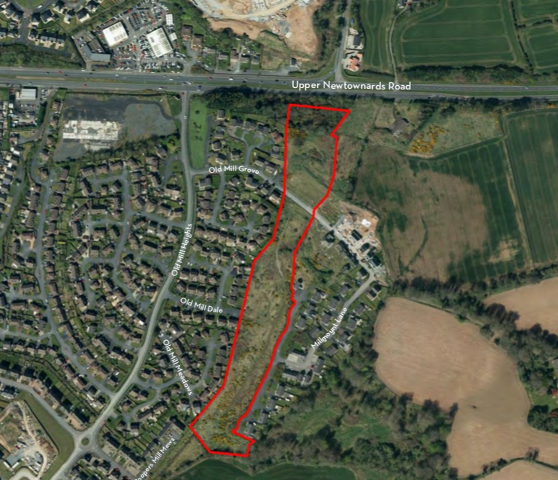
Map showing the area of the road corridor
that the developer wishes to build homes on,
as of June 2019 [Fraser Homes].
|