|
|
Status
|
Construction scheme
(proposed) |
|
Where
|
To
build a new bypass around the east of
Downpatrick from the A25 Strangford Road
to the B1 Ardglass Road. |
|
Total
Length
|
3.7 km / 2.3 miles
|
|
Dates
|
Initial scheme
appraisal carried our by DRD - Aug 2005
Included in Sub-Regional Transport Plan
(SRTP) - June 2007
Included in Ards and
Down Area Plan - March 2009
TransportNI initiate new feasibility
study - Aug 2016
Feasibility study recomments not
proceeding with the scheme - Mar 2018
|
|
Cost
|
£18.3m - as of 2017
|
Anyone familiar with Downpatrick will be
familiar with the congestion in the town centre
as so many of the local roads converge at Irish
Street, Church Street and Market Street. This
road proposal would see a new road built around
the east of the town, not forming a full
"bypass" of the town, but allowing traffic to at
least bypass the town centre by linking together
several radial routes.
Confusingly, the 2009 Ards and Down Area Plan
uses the alternative name "Downpatrick Link
Road" for this scheme, while the 2010
Downpatrick Town Centre Masterplan has adopted
the term "Eastern Peripheral Route".
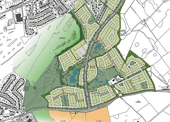
The proposal is divided into four elements,
shown on a map below this description:
- Strangford Road to Saul Road
(1.4 km), which will be built by upgrading a
small stretch of Rathkeltair Road and then
following a new route to Saul Road, meeting it
just east of Ardfern Road. Provision of this
part of the Bypass has been linked to the
development of about 11 hectares of land zoned
for housing at Ardenlee Gardens, as you can
see in the relevant section of the 2009 Ards and Down Area
Plan (see proposals DK 08 and DK 17).
The route of this part of the Bypass is,
therefore, relatively well known, but
provision will be dependent on the private
developers of the housing area. It is shown in
blue on the map below.
- Saul Road to Ballyhornan Road (1.5
km), which will be built on a new route
through the countryside. The 2009 Ards and Down Area
Plan links the development of about 52
hectares of housing land in this area to the
provision of this part of the road, which is
likely to require a developer contribution
(see proposals DK 07, DK 12 and DK 13). The
route of this part of the road is very
uncertain, and has yet to be pinned down
precisely. It is shown in red
on the map below.
- Ballyhornan Road to Struell Wells Road
(0.3 km), which will also be built on a new
route through the countryside and is dependent
on two housing developments mentioned in the
previous section (proposals DK 12 and DK 13).
Like the previous section, the route of this
part of the road is very uncertain, and has
yet to be pinned down precisely. It is shown
in green on the map below.
- Struell Wells Road to Ardglass Road
(0.5 km). Although the 2007 Sub-Regional
Transport Plan suggested an entirely new road
to connect Struell Wells Road to Ardglass Road
through the countryside, the 2009 Ards and Down Area
Plan instead recommends the upgrade of
an existing stretch of Struell Wells Road to
meet the existing roundabout on Ardglass Road
(see proposal DK 13). The development of a
housing site of about 6 hectares at Struell
Wells Road has been made dependent on this
work being completed, and hence the developer
may be asked to contribute to it. This would
complete the Eastern Bypass. It is shown in orange
on the map below.
View Downpatrick
Eastern Bypass / Link Road in a larger
map
(Alternatively, you can see the road proposal
marked as a dotted line in Map
No. 3/002a in the 2009 Ards and Down Area
Plan.)
The 2009 Ards and Down Area Plan stresses that "The
road lines ... between Saul Road and Struell
Wells Road are indicative only. Concept Master
Plans and indicative concept plans, which will
accompany applications for development of these
lands, will be required to include the proposed
line of the relevant development road." One
such master plan was the Downpatrick
Town Centre Masterplan, published in draft
form in 2010, and which included a transport
report. The report used the same basic route
as was included in the Ards and Down Area Plan,
but recommended three changes:
- that the Eastern Bypass be linked to the A7
north of Downpatrick by upgrading the existing
Finnebrogue and Cotterhill Roads (visible by
scrolling the above map northwards and zooming
in).
- that a supplementary link road be built
connecting Quoile Road to Strangford Road (see
page 163 of the transport report).
- that the Eastern Bypass be supplemented to
the south of the town centre by another new
link road connecting Killough Road to
Ballydugan Road, relatively close to the town
centre, so that traffic on the Eastern Bypass
could travel along Ardlgass Road into the town
before using the link to get to the A25
Ballydugan Road. The location of such a link
was not set out in the plan.
These suggestions have not been taken any further
by Roads Service at the time of writing (2013).
Updates
5 Jul 2024: In the previous update I
noted how DFI had decided that they would not
fund this road with public money, but that it
should be made a condition for new housing in
the area. This week it was reported
locally that CosyGroup are considering
building 1100 new homes on a site east of the
town (see proposals DK 07, DK 12 and DK 13 in
the Ards
and Down Area Plan) and, as part of this,
would construct the 1.5 km section of the
Eastern Bypass that connects Saul Road to
Ballyhornan Road, shown in red in the map
further up this page. They also released the
graphic below, which shows a road on the line of
the proposed Bypass. I cannot find any planning
applications related to this, so clearly it is
still at an early stage of planning.
Nevertheless, it is the first hint that at least
part of the Eastern Bypass may eventually get
built.
CosyGroup image from July 2024 showing
Ballyhornan Road running left-right with a
section of the proposed Bypass running through a
site of new housing. This site is currently
fields. [CosyGroup]
13 Feb 2022: Going through the web site
recently I realised that I neglected to update
this page with the results of the feasibility
study that I referred to in the 2017 update
below! The feasibility study was published
in March 2018 and was not supportive of the
proposed scheme. The analysts calculating the
benefit/cost ratio (BCR) for the scheme.
Basically, this is the estimated financial
benefit from the scheme for the sixty years from
2030 divided by the construction cost. Anything
below 1 indicates a scheme that would cost more
than the benefits it would bring. The BCR for
the Downpatrick Eastern Bypass is 0.3,
indicating that it would be poor value for
money. The BCR was then re-calculated assuming
an addition of 1630 new homes in the area by
2030. In this case the BCR was 0.913 which was
closer to 1, though still not good value. The
report concluded that "there is no economic
justification for proceeding with the Eastern
Distributor Road". However, I don't think
this is the end of the matter as this argument
only applies if it was public money being spent
on the road. The scheme is set to cost around
£18.3 and be just under 4km long, making it not
dissimilar to the £11m / 3 km Ballyclare
Western Relief Road which is currently
under construction and is being privately funded
as a condition of planning for nearby housing.
There would be a strong case for making
provision of all or part of the Downpatrick
Eastern Distributor a condition of planning for
housing developments in the east/south
Downpatrick area. In this case, the
justification for the provision of the road
would not be the economic benefit, but rather to
offset the additional traffic that the new
developments would add to the existing road
network. This is quite justifiable and something
that the local council ought to consider,
especially as new local area plans are currently
being drafted.
30 Nov 2017: In the last update I
reported that the former DFI Minister initiated
a new feasibility study into this proposal. The
October
report to Newry, Mourne and Down District
Council indicates that "Work on the
feasibility study is now substantially
complete. It is anticipated that the
feasibility study report will be finalised
over the coming weeks." If it has been
completed, it hasn't been made public so we
can't say anything more about its contents. I
would speculate that it basically says "yes,
this scheme would bring benefits, especially if
the town grows". However my intuition is telling
me that this project is not a priority within
DFI when compared to all the competing
proposals, so short of some private developer
funding it as part of a major housing
development, I'd be very surprised if we see
much more movement on this proposal in the next
few years.
8 Oct 2016: This is one of those road
schemes that has languished on the "would be
nice" pile for years and years. But lo and
behold, the Minister actually mentioned it in a
press
release during August. While he was in
Downpatrick to talk about a possible one-way
system for the town, he also said this: "Many
local residents and businesses have long
called for an Eastern Bypass or Distributor
Road to be given serious consideration as a
means to alleviating congestion throughout
Downpatrick and also as a vital piece of
infrastructure to allow the local economy to
flourish. I have taken the decision to
initiate a feasibility study of the scheme
which will assist my department in discussions
with key stakeholders on the possibility of
providing this road in the future." Now,
it has to be pointed out that Roads Service
already carried out a feasibility study into
this road in 2005, and much of the detail listed
above was as a result of this. However to be
fair to the Minister ten years is a long time in
road building terms and it is probably no harm
to go back to reconsider the options after this
length of time. But having said that,
it's hard to see this particular scheme managing
to fight its way to the top of the funding
priority queue even in the next ten years when
it would be competing with schemes such as the
A5, A6 and York Street Interchange, and the
Ballynahinch and Enniskillen bypasses which seem
likely to use up most of TransportNI's capital
funds for some years to come.
16 July 2013: Two weeks ago, the DRD
Minister was asked about progress on this scheme
via a Written
Answer (AQW 24167/11-15). His answer does
not offer much hope of imminent provision of the
Eastern Bypass, but does at least confirm that
it is still considered to be a live proposal by
Roads Service. He said "In the longer term,
there is also an Eastern By-pass proposal
identified in the Ards and Down Area Plan. The
Plan envisages this bypass will be provided
through developer contributions".
|
