Status |
Construction scheme (completed) |
Where |
Realignment of some roads and removal of others to make way for the St Anne's Square development in Belfast's Cathedral Quarter. |
Total Length |
n/a |
Dates |
Work began June 2006
Completion due September 2006
(Closure of Edward Street from Exchange St to Exchange St West due to take place later, in Autumn 2006).
New traffic lights with Dunbar Link switched on 4 December 2006 |
Cost |
? |
Photos |
See below. |
See Also |
General area map
Artist's impression of St Anne's Square - Laganside Corporation |
Belfast's Cathedral Quarter, roughly the area bordered by York Street / Donegall Street / High Street / Dunbar Link contains the beautiful 100-year-old St Anne's Cathedral. However, it also contains some of the most run down areas of the city centre. The streets to the north east of the cathedral are particulary neglected with large tracts of empty land and dereliction. One scheme that has just got under way is to build "St Anne's Square", what will be a prestigious commerical and residential area with views towards the rear of the Cathedral also incorporating a new multi-storey car park.
This scheme as designed requires a large plot of land and thus cannot take place without the removal of several streets. The following succinct planning application was approved by Belfast City Council in May 2006: "Construction of a new road junction at Edward Street and Dunbar Link; relocation of the junction of Talbot Street with Dunbar Link; and the provision of a new link road between Hector Street and Edward Street". I e-mailed Laganside and got a much more detailed description of the works, which I have interpreted as best I can via the following map:
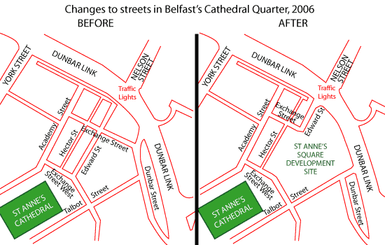
Changes to Cathedral Quarter streets (map based on Google Earth imagery).
Essentially the scheme is designed to create a large block of land by obliterating the southern part of Edward Street, the eastern end of Exchange Street and the northern end of Dunbar Street. Access to the site will be improved by the opening of Edward Street onto Dunbar Link. It will turn the Nelson Street junction into a cross roads instead of the existing T-junction. Commuters should notice little disruption on Dunbar Link. St Anne's Square will consist of tall, classical-styled buildings which are focused on a narrow gap at the south west end giving a tantalising view to the rear of the Cathedral. See link above for an artists impression.
Personal Comments
It is a shame that St Anne's Square cannot be designed in harmony with the existing street pattern, which goes back over two centuries. Many old streets in Belfast city centre have been demolished over the years (eg Sailortown, now under the M2; Smithfield, now under Castlecourt). From the experience of historic cities such as Rome or Venice, we can see that often the most interesting cities are the ones which have preserved and enhanced their old street pattern, rather than obliterating it. St Anne's Square will undoubtedly be a beautiful development, and the area was in dire need of redevelopment, but was it necessary to completely obliterate the old street pattern? Surely the desire to meet the changing needs of an historic city centre is best served by the tasteful incorporation of new developments into the existing streets, not their obliteration?
- Exchange Street was first built in 1767 under the name "Green Street". By the 1820s it was a residential area with 65 homes and was redeveloped again around 1890. It was renamed Exchange Street in 1903. The section from Corporation Street to Dunbar Street was obliterated by the Dunbar Link around 1980, with half the remainder being removed in 2006. Three surviving terraced houses dating from 1885, now derelict, will also go.
- Edward Street was originally known as "Patrick Street" and then, by 1805, as "Joy's Row" after George Joy who leased the lands at this time. By 1819 it had been named "Edward Street" and was residential, containing 60 homes. The south part will be obliterated in 2006, and the northern part turned into an access road for St Anne's Square.
[Information from "Central Belfast - A historical gazetteer" by the Ulster Architectural Heritage Society, 1993, ISBN 0900457457.]
Photos
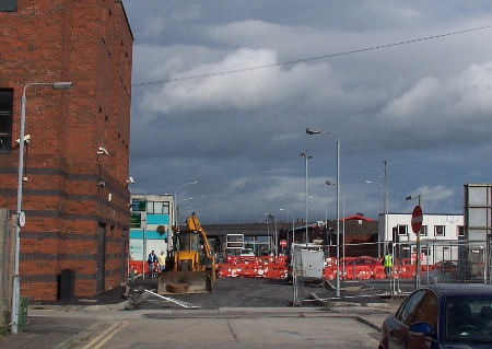
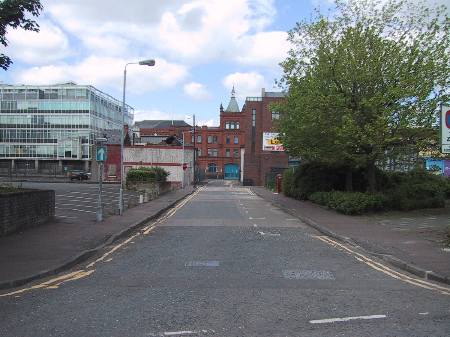
Work ongoing to build the new signalised link from Edward Street (which we are looking along) onto Dunbar Link in early October 2006. [Photo by Wesley Johnston]
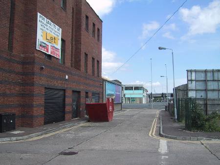
Similar view to above before work began: Looking north east along Edward Street, from Exchange Street, and towards Dunbar Link in 2002. This will become the new access road into the area. [Photo by Wesley Johnston].
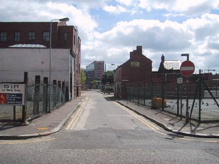
Looking south east along Exchange Street from Academy Street in 2002. Three houses dating from 1885 are visible on the right. [Photo by Wesley Johnston].
Looking south west along Edward Street, from Exchange Street in 2002. This part of the street will be obliterated by this scheme. As you can see, the area is largely open and underdeveloped. [Photo by Wesley Johnston].
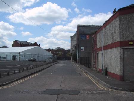
Looking north west along Exchange Street from Dunbar Street in 2002. The first half of this road (as far as the building with red stripes) will be obliterated. [Photo by Wesley Johnston]. |
