|
|
Status
|
Construction scheme
(future)
Contractor: Sisk,
Roadbridge, PT McWilliams, Fehily
Timoney Gifford
|
|
Where
|
To
upgrade the A5 by building a new high
quality dual-carriageway from just south
of Strabane to just south of Omagh |
|
Total
Length
|
32.7 km / 20.3
miles
|
|
Dates
|
For background to
scheme see
the page on the whole A5 project.
17 July 2007 - Executive decides to
proceed with plan
21 July 2009 - Preferred route announced
May, June 2011 - Public Inquiries held
9 Nov 2011 - Irish government postpones
financial contribution
Sep 2012 - Work due to begin but halted
due to legal challenge
Autumn 2016 - New public inquiry (for
entire A5 scheme)
Early 2025 - Construction planned to
begin on this stretch (as of Oct 2024)
2028 - Completion assumed (as of Oct
2024)
|
|
See
Also
|
General area
map - Google Maps
Whole A5
scheme - on this site
Official
web site on whole A5 scheme
|
Click here to jump straight
down to updates for this scheme.
This scheme is part of the ambitious plan to
upgrade the entire 88km A5 to high quality
dual-carriageway standard from Newbuildings
(just south of Derry) to Aughnacloy. See here for
details and history. In October 2024, DFI
announced that this stretch would be split off
and built as a separate phase.
The road will be built to dual-carriageway
standard with two lanes each way, no side accesses
and no hard shoulders. The technical term for this
standard is "Category 6". The strip map below
shows the design of the road.
Junction Strip Map
Dotted lines indicate planned future extensions.
|
NORTH
Begins as
A5 Melmount Road, Strabane
(approx 0.5
miles / 1 km south of Strabane)
|
|
Junction
8:
(Strabane South)
|
|
|
Current
A5
into Strabane
B?? (Current A5)
into Sion Mills
|
| |
|
Junction 9:
Victoria Bridge |
|
|
B72 Fyfin Road
into Victoria
Bridge
|
| |
5.8 km / 3.6 miles
|
|
Junction
10:
Newtownstewart
|
Drumlegagh
Road North
B84 Baronscourt Road
.
|
|
B84
Baronscourt Road
into Newtownstewart
|
| |
12.0 km / 7.4 miles
|
|
Junction
11:
Omagh North
|
|
|
B?? (Current A5)
Beltany Road
A?? (Current
A5)
Beltany Road
Into Omagh
|
| |
5.7 km / 3.5 miles
|
|
Junction
12:
Omagh West
|
A32 Clanabogan Road
("Dromore Road")
towards Enniskillen
|
|
A32 Clanabogan Road
("Dromore Road")
into Omagh
|
|
SOUTH
Terminates
with next phase of project, due to
be under construction concurrently.
|
The road itself follows a route somewhat to the
west of the existing A5. You can see the design as
proposed by going to this link.
Updates
9 Oct 2024: This page has been created
due to the announcement that this element of the
scheme is to go ahead, commencing in early 2025,
the first part of the A5 upgrade to take place.
The stretch immediately to the south, to
Ballygawley, will begin a year later. The two
stretches will be built by different
contractors, but will both meet at a single
point, at Doogary, just south of Omagh. At the
north end, this stretch will terminate at a
temporary terminus featuring a roundabout on the
existing A5 between Strabane and Sion Mills. The
map below shows the plan for this junction once
completed – presumably the sliproads will be
built but the dual-carriageway will not be
opened initially and all northbound traffic will
have to exit onto the A5 to continue north. If
the planned future extension to Newbuildings
gets built, it will continue from that location.
Going forward to this page will be used to
follow the actual construction of this stretch.
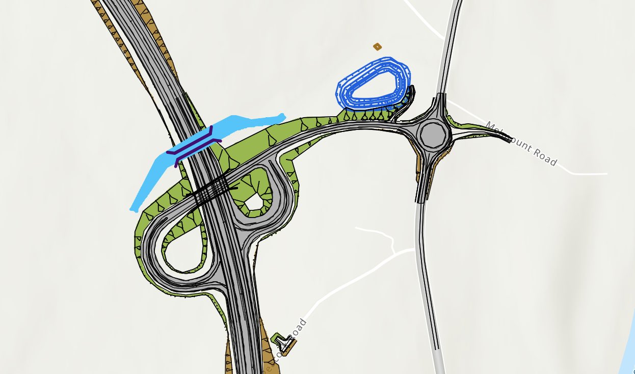
Planned layout of Junction 8 of
the new A5, just south of Strabane. This stretch
begins at this junction and heads south.
|


