Status |
Construction scheme (completed) |
Where |
To widen Sligo Road, Enniskillen to provide two lanes leading onto Henry Street |
Total Length |
Approx 0.2 km / 0.1 miles |
Dates |
Work began Spring 2008
Road upgrade completed early Dec 2008
(about 3 months behind original schedule)
Ancillary works due to be completed during Jan 2009 |
Cost |
£1.7m |
Photos/Map |
See below |
See Also |
Enniskillen southern bypass - on this site
View of completed works - Google StreetView
|
The A4 road connecting Belfast to Sligo passes through Enniskillen. Despite the construction of the Enniskillen Throughpass in 1986, the road was severely congested with traffic coming into town along the Sligo Road frequently extending a mile or more back from the traffic lights at the west bridge, leading to delays of half an hour or more on a typical journey.
One of the pinch points was where Sligo Road meets the two west bridges - the historic Castle Bridge, and a parallel modern bridge opened in 1982. The Sligo Road had one lane in each direction here because it was confined between terraced buildings on one side, and the steep banks of the Erne on the other. This means that only a single line of traffic could pass through the lights into the town. If a second parallel lane were added, the throughput of the junction would double at a stroke, leading to a marked improvement in congestion on the Sligo Road.
Despite the longer term plan for a southern bypass that will carry through traffic away from the area, this scheme was progressed partly as a stopgap, and partly because it would lead to improvements for local traffic commuting into the town. This scheme was much more complicated than a traditional urban widening scheme since it involved the construction of a very deep, strong retaining wall on the banks of the ecologically sensitive Erne and as a consequence was extremely expensive. It also involved the provision of a new footway, a section of footbridge, cycleway, a parking bay on Sligo Road and a complex draingage system to prevent pollution of the Erne.
The total cost of the scheme was £1.7m, including land and fees. The contractor's cost was £842,000. The contractor was Lagan Construction.
Maps
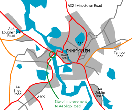
Site of the Sligo Road / Henry Street widening project in Enniskillen.
(Map based on Google Earth imagery.)
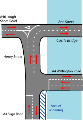
Sketch map of the Henry Street / Sligo Road area prior to work commencing, and an indication of the area of the widening works. (not to scale)
Progress
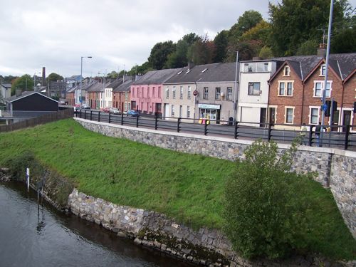
19 Oct 2010: The road has now been open almost two years, but I have finally got a chance to take an "after" picture which I share below. Compare this to the image taken in July 2010. It is difficult to overestimate the impact this scheme has had on traffic in Enniskillen in the past two years.

The completed scheme looking very natural on 3 October 2010. Seen from the Wellington Road bridge with Sligo Road straight ahead. [Wesley Johnston]
2 Feb 2009: With the road being opened in early December 2008, ancillary works continued during January. The scheme is now being regarded as completed.
2 Jan 2009: The second lane opened to traffic in early December and, according to Roads Service, has been extremely successful at reducing congestion on the Sligo Road. Works to the pavements and cycle paths will continue during January.
26 Sep 2008: Work was originally due to be completed by now, but unfortunately "difficult ground conditions around No.6 Henry Street" has meant that additional works had to be carried out, which has pushed back completion to "early December". It is expected that the structural works will be completed by mid October, and the construction of the new road surface will take place after that.
July 2008: The photo below shows work well underway on the scheme.
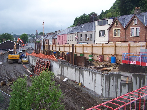
Progress on the new retaining wall at Sligo Road, as seen from the Wellington Road bridge in early July 2008. [Wesley Johnston] Photos
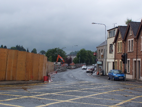
Looking south along Sligo Road in early July 2008, with work well underway. Seen from Henry street. Sligo Road ahead will be widened to three lanes and a parking bay along the front of the buildings on the right. [Wesley Johnston]
The completed scheme seen from the Wellington Road bridge in October 2010. [Wesley Johnston] |
