Status |
Construction scheme (completed) |
Contractor |
Lagan Construction Limited |
Where |
To dual the main A2 from Maydown on the edge of Londonderry city to the City of Derry Airport. |
Total Length |
6.8km / 4.3 miles |
Dates |
Public consultation began - 22 Feb 2005
Preferred route announced - 1 Nov 2005
Public inquiry held - 27/28 Mar 2007
Advance site clearance began - Feb 2009
Work began around 8 June 2009
(revised from "early 2009" as of Aug 2008, and "late 2008" as of Feb 07)
Offline section opened to traffic - 9 Sep 2010
Work due to last "approximately 18 months" (as of May 2009), therefore:
Road fully opened to traffic and cones removed - 11 Feb 2011
Official opening took place 23 Feb 2011 (around 2 months behind schedule) |
Cost |
£45m (as of Feb 2011)
including £4.5m from ILEX, the Derry regeneration company (as of Feb 2011)
|
Photos / Map |
See maps linked below. |
See Also |
General area map |
This scheme is part of the wider strategy of improving the strategic road network in Northern Ireland. As the main route connecting Londonderry and Coleraine, it also feeds large industrial sites at Maydown and Campsey as well the growing City of Derry airport. The section closest to the city carries 17,000 vehicles per day, while the section to the airport carries 12,000.
It has been decided to upgrade the route to dual-carriageway standard. Seven options were initally considered, whittled down to two: - a fully on-line upgrade (same route upgraded) and a partially off-line upgrade (part of the route completely new). In November 2005 the latter option was announced as the preferred scheme after a public consultation. More detailed maps of the route were published late in 2006 and come in three parts (PDF format):
Maydown to Campsey | Campsey to Broadbridge | Broadbridge to City of Derry Airport
From Maydown to Campsey, a new westbound carriageway will be constructed to the south of the existing road, with the existing road used as the eastbound carriageway. East of Campsey, the road will be constructed entirely offline with roundabouts at Campsey, Broadbridge and the City of Derry airport. The existing A2 east of Campsey will be retained as a local road to access properties.
All along the new route there will be *no* central-reserve crossing points, one of the main causes of accidents on dual-carriageway. Instead, a series of parallel roads will be constructed to access homes and farmland. Where side roads do join the new road, they will do so with LILO (left-in, left-out) access only. Traffic wishing to turn right will turn left and do a u-turn at the next roundabout.
The cost of £19.8m given in 2005 had risen to £25m by the time this public consultation was released in July 2006. This cost had almost doubled to £46m by August 2008. When construction began in June 2009 the cost was being given as £24m. This is likely to be the construction cost, ie not including land acquision and other non-construction costs which brings the total to the £46m mark.
Progress
2 Mar 2011: The road was officially opened on 23 February by the "roads" Minister Conor Murphy. Congratulations to Lagan Construction Limited on a great piece of work. The total cost is now confirmed as £45m, of which 10% was paid by the Integrated Development Fund. The BBC has reported some controversy around the fact that a local placename is spelled in two ways ("Campsey" on some signs, "Campsie" on others). Former Sinn Fein MLA Francie Brolly dismisses the controversy noting that "both are an English rendering of a Gaelic name, so it's irrelevant which way it is spelled". While the spelling of placenames is hardly "irrelevant", his explanation of the source of the controversy is correct. The placename is an Irish name which has been Anglicised and there is thus no "correct" English spelling. The Ordnance Survey of Northern Ireland is normally used to settle such disputes, as they are the only organisation to systematically record townland names. Their spelling is "Campsey". However, this is more a convention than anything definitive, so we can say that while it may be inconsistent, neither spelling is "wrong".
14 Feb 2011: According to site visitor Michael Edwards, all the cones and speed limit signs were removed on the morning of Saturday 12th February. Although the road has not been officially opened, it appears to be essentially completed. At project commencement the scheme was to have taken 18 months, so this is two to three months behind schedule, which is apparently partly due to the very severe weather we endured in December. The press release linked above gives the cost of the scheme as £25m, which is confusing since Roads Service's own web site is still giving the cost as "£45m-50m". Perhaps the £25m is the construction cost alone, while the higher cost includes land and compensation. The completion of this scheme means that there are now NO new roads under construction in Northern Ireland for the first time in several years.
14 Jan 2011: At the end of 2010 Roads Service were saying that the expected the loose ends of this project to be completed during December. This has not happened, and the document linked above refers to "a legal challenge" that might delay completion. It's not clear what this might be. Minutes from a meeting in November said that the official opening was "tentatively" planned for 19th January 2011. This may yet happen.
19 Sep 2010: The entire offline section of dual-carriageway between Campsie and City of Derry Airport did indeed open to traffic on 9th September, with both lanes in each direction available (see pics). The road looks excellent and all those who have e-mailed me in the past week have been full of praise for what has been built. Only the online section between Maydown and Campsie, the section which includes the River Faughan bridge, is still under construction. Roads Service are currently saying that completion is due "by the end of the year". They have also put some new pictures on their web site here. The pictures below are with thanks to Stephen Baxter. Thanks also to Robin Cunningham for recent info.
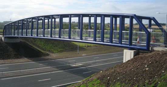
The attractive new Broadbridge footbridge over the new A2, seen on 12 Sep 2010. The next two pictures were taken from this bridge [Stephen Baxter]
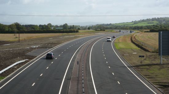
Looking east along the newly opened dual-carriageway from Broadbridge footbridge towards City of Derry Airport on 12 Sep 2010. [Stephen Baxter]
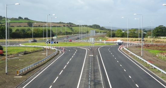
The recently-opened Broadbridge roundabout on the new A2 seen
from Broadbridge footbridge on 12 Sep 2010. [Stephen Baxter]
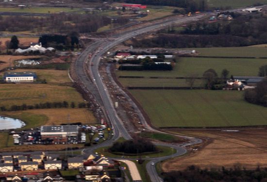
11 Sep 2010: There are unconfirmed reports that the easternmost part of the scheme (the offline section from Campsie to City of Derry Airport) opened to traffic a couple of days ago. This is very good news. I have also found a lovely set of aerial photos of the scheme dating from May hidden here on the Roads Service web site. (Roads Service have a habit of updating sub-pages on their web site without telling anybody - for example, the main page on the scheme still says that it was last updated in February.) There seems little point in posting the images here after four months, but they are worth a look if you are interested in the scheme.
11 Jul 2010: In a press release five days ago the 'Roads' Minister confirmed that this scheme is still on schedule with completion still anticipated in November, ie about four months' time. The Minister said “The dualling of the A2 Clooney Road is progressing well with the majority of the earthworks and drainage now complete. The works remain on programme and my Department expects the scheme to be completed in November". In time terms the scheme is almost 75% completed.
23 May 2010: According to site visitor Robin Cunningham the two easternmost roundabouts (at Broadbridge and the City of Derry Airport) were in use at the start of this month, and the original A2 at Broadbridge has now been closed off. Roads Service have also been posting up their own photos of the scheme on their web site here. The one below is the most recent (dating from early March) and shows one of the new bridges almost completed. Completion is due in November, around six months from now and there is currently nothing to suggest there are any issues with this timescale.
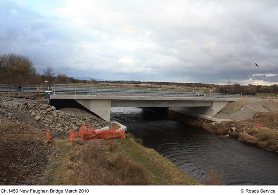
New Faughan Bridge on the A2 in early March 2010. [Roads Service]
27 Mar 2010: Roads Service's web site is now giving the cost of the scheme as £45m - £50m, which is more in keeping with the figure of £46m given in August 2008. This was confused in May 2009 when the cost was given as £24m.
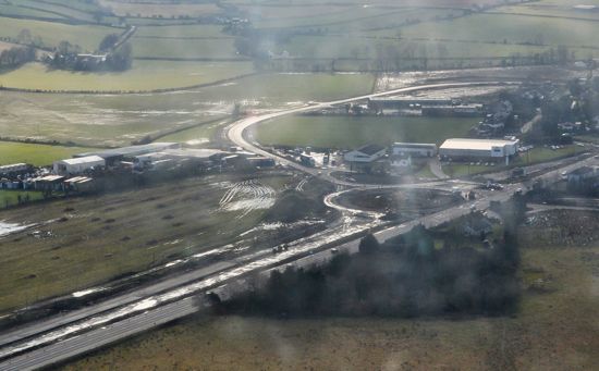
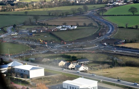
2 March 2010: There has been excellent progress since the last set of images in the autumn. The pictures below were all taken a few days ago by Robin Cunningham (need help with VAT?) from a light aircraft. The first shot shows the existing Maydown roundabout at the western end of the scheme, seen looking east. The existing dual-carriageway can be seen at the bottom of the shot, while the existing single-carriageway A2 is still in place beyond the roundabout. However, it is clear from the picture that the new dual-carriageway is being constructed around it. In the top right corner you can see a second bridge being built over the Faughan river, which will form a pair with the existing bridge. To the right of the new road you can see a new parallel access road, which joins the roundabout. The second shot shows the new Campsey roundabout taking shape, here seen looking west. This is a new roundabout, and it is well underway although the existing A2 clearly still runs unhindered through the middle. The clearly visible C-shaped road beyond the roundabout is a new road that will provide access to existing properties in the settlement of Campsey, visible here on the right. The final shot shows the new Broadbridge roundabout taking shape, here seen looking south east with Campsey Industrial Estate visible in the foreground. At this point the new dual-carriageway is being built offline, ie away from the existing A2, which can be seen in the foreground. The new roundabout looks to have kerbing in place, but no surface as yet. The road at the upper right is a new road that will replace the one at the top left which will be stopped up. Many thanks to Robin for these excellent images. Completion is still anticipated to be in November, around eight months away.
Pic 1: The view east from Maydown roundabout on 27 Feb 2010. [Robin Cunningham]
Pic 2: New Campsey roundabout taking shape, looking west on 27 Feb 2010. [Robin Cunningham]
Pic 3: Looking south east over the current A2 towards the new dual-carriageway and new Broadbridge roundabout on 27 Feb 2010. [Robin Cunningham]
7 January 2010: According to this press release, the scheme is progressing well and is still on schedule for completion in November. The information also says that "Ten archaeological sites were uncovered during the earthworks for the scheme. Site work is now complete on these finds and a report is being compiled by the archaeologists for the Environment Agency."
8 Sep 2009: Work has now been underway for three months. Those travelling along the existing A2 can see plenty of evidence of widening works. The picture below was taken about a week ago and shows the view looking towards Derry at the western end of the scheme (approaching Maydown roundabout). At this point the single-carriageway road is being widened to dual-carriageway. A parallel agricultural access road is also being built on the left. So the works evident here are either the new citybound carriageway or the parallel access road. The new road largely follows the existing road, but it weaves from left to right to achieve the optimum curve geometry so it's not simply a matter of constructing a second carriageway beside the current one.
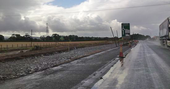
The view west from the A2 approaching Maydown roundabout with
work evident on the left. Taken on 3 Sep 2009. [Diarmaid Elder]
6 July 2009: Although work has been underway now for almost a month, the Minister for Regional Development cut the first sod on Wednesday, 1st July - obviously more of photo opportunity than a literal commencement! He said "This project has considerable local support and I am pleased to see the work started. The improvements will greatly improve journey times for both strategic traffic and other road users in the local community and will, in turn, contribute towards the continued economic development of the north and efforts to improve road safety." He also implied that he currently favours schemes in the North West over schemes elsewhere by saying "Since taking up office I have been committed to tackling the years of under investment in the north west and to the delivery of balanced regional infrastructure throughout all of the north."
23 June 2009: According to site visitor Paul McCloskey, work is now underway, and indeed began around 8 June. Signs of the construction of the new carriageway are already visible at the eastern (airport) end of the scheme.
14 May 2009: The Minister for Regional Development has officially announced the awarding of the contract, which he says will begin "later this month", ie within two weeks, and will last 18 months. This means the road should be complete by the end of November 2010. He also gives the cost as £24m, which is considerably less than the cost of £40m given last August - it is not clear wht this is although there was been quite a bit of talk in Roads Service meetings about the "funding profile" of this scheme in recent months. The Minister also says that Derry's redevelopment body ILEX is contributing £4.5m to the project, money which has been sourced from the Executive's Integrated Development Fund. The Minister describes the project as "a further example of my commitment to improving infrastructure in Derry and the northwest, in line with the Executive’s priorities, to allow this region to maximise and realise its full economic potential."
28 April 2009: The contract for the scheme was formally signed with Lagan Construction Ltd on Friday, 24 April. We can therefore expect work to begin imminently, although site clearance work has been underway since February.
26 Feb 2009: According to site visitor Stephen Baxter, advanced site clearance works have begun, mainly clearance of vegetation from the verges. Last week Roads Service published the vesting orders that are required to acquire the land for the scheme.
2 Feb 2009: According to this Assembly written answer, the scheme is due to get underway in April or May 2009, and that work will last 18 months, which suggests completion in October or November 2010. The answer also confirms that the standard of the proposed road is still a good standard dual-carriageway with roundabouts and no central reservation crossings. Tenders from contractors are due to be returned by the middle of February 2009.
10 Dec 2008: According to this press release, tenders have been invited but the start of work on the ground has been put back from "early 2009" to "the next financial year", which likely means April 2009 or beyond. (The Roads Service web site is still giving the commencement date as "late 2008" but this is clearly old information.) Also, Roads Service published a leaflet on the scheme last month. It doesn't say anything new, but provides a useful summary of the scheme.
26 Aug 2008: Having considered the findings of the public inquiry, Roads Service have now decided to proceed with slight modifications to the design (a left-in/left-out junction at Donnybrewer Road, a realignment of the Cloghole Road Link and other minor land take amendments). This will require some additional land vesting. The latest press release gives the cost as £46m, representing an increase of at least £16m on the previously publicised figure. The press release also states that the commencement date has slipped, from "late 2008" to "early 2009".
15 Jun 2008: Speaking to a Roads Service person recently, there seems to be question mark over the standard of the scheme. The scheme as publicised in 2006 (see "Maps" below) contained parallel access roads for long lengths to access farmland. However, there seem to be legal problems with these parallel access roads. Roads Service does not want to be responsible for maintaining roads that only access a handful of private properties, but the residents naturally don't want to be responsible either. If these problems cannot be rectified, they may abandon the parallel access roads and reduce the quality of the scheme by allowing private accesses directly onto the road. Also, this press release suggests that completion will be "substantially completed by 2010/11". This is later than the "late 2010" date being advertised as of Feb 2007 which was dependant on construction beginning in "late 2008". This suggests that work may not now begin until 2009.
15 Feb 2007: According to the Roads Service web site, construction commencement has been pushed back from "early 2008" to "late 2008", possibly due to the need for a public inquiry.
Maps
Detailed maps of the route were published late in 2006 and come in three parts:
Maydown to Campsey | Campsey to Broadbridge | Broadbridge to City of Derry Airport
|
