Where |
Forms an arc to the south and connecting the suburbs of Bangor |
Total Length |
6.5 km / 4.1 miles |
Opened |
First section 1964
Completed by 1971 |
Cost |
£700,000 in 1964 prices
(£9.5m in 2005 prices) |
Photos |
See below. |
See Also |
General area map
|
Construction
In the late 1960s the role of the former resort town of Bangor was changing to become a residential town. High rates of growth were taking place, which led to the town reaching 40,000 people by 1971. The existing road system became strained and it was decided in the late 1950s to construct a ring road (or more exactly a southern relief road) that would run in a gentle arc from the Belfast Road in the west, south past the A21 road to Newtownards and then to the north east stopping just short of Groomsport.
The original plan publicised in 1960 shows the road joining the Belfast Road at a roundabout, but by 1962 this had been abandoned in favour of a grade-separated junction. The road was constructed in several stages:
- Newtownards Road - Bloomfield Road opened on 23 Oct 1964 at a cost of £140k (£1.9m in 2005 prices). Work had begun in Aug/Sep 1962.
- Newtownards Road - Clandeboye Road opened on 22 Apr 1966.
- Clandeboye Road - Springhill Road tenders invited Apr 1966. Opening date unknown.
- Bloomfield Road - Groomsport Road tenders invited Autumn 1966. Opening date unknown.
With thanks to Andew Muir for doing research into these dates and costs.
The Road Today
While several local roads open directly onto the Ring Road, the key junctions on the route are, from the west:
- A2 Belfast Road (grade separated)
- Clandeboye Road (traffic lights)
- A21 Newtownards Road (roundabout)
- Bloomfield Road (roundabout)
- Gransha Road (roundabout)
- Donaghadee Road (roundabout)
- Groomsport Road (roundabout).
The entire road was built to dual-two-lane standard. The town today has almost 60,000 residents but the Ring Road, while heavily used, just about copes. This is a testament to the forward thinking of the road planners who built a future-proof road that was probably criticised at the time for being extravagant. Traffic levels tend to be highest at the centre and western ends. The longest of these key sections is the Gransha to Donaghadee Roads section which is 1.5km (0.9 miles) long.
One could argue that the Ring Road is now a second "main street" for the town, being home to two shopping centres and three retail parks and being the principal route for most residents. It probably generates as much commerce as the traditional town centre area of the town.
Photos
With thanks to Andrew McCullough and Aubrey Dale for supplying the photos below.
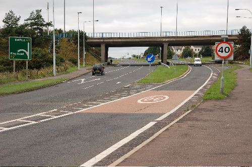
The Bangor Ring Road begins on this bridge over the A2 Belfast Road, here seen looking west. This is the only grade-separated junction on the route. [Photo by Aubrey Dale]
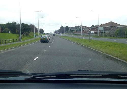
Heading east on the ring road just after the start of the dualled section at the A2 Belfast Road sliproad. [Photo by Andrew McCullough]
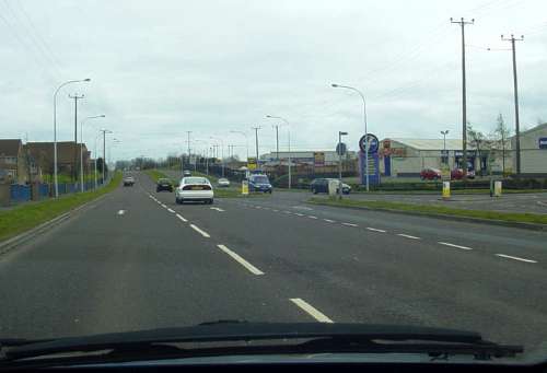
Probably the busiest section passing Balloo Industrial estate between the Newtownards Road and Bloomfield Centre. [Photo by Andrew McCullough]
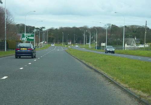
Approaching the end of the ring road at Groomsport Road roundabout, the fifth roundabout on the route. [Photo by Andrew McCullough]
|
