|
|
Status
|
Construction scheme
(completed) |
|
Where
|
Construction
of a roundabout on the A26 Ballymoney
Bypass at the junction with B16 Kilraughts
Road. |
|
Total
Length
|
n/a |
|
Dates
|
A26 Ballymoney Bypass
built - 1979
Scheme announced - June 2004
Construction began - Dec 2004
Opened to traffic - April 2005
|
|
Cost
|
£600k -
£700k
|
|
Photos
|
See below for map. |
|
See
Also
|
Kilraughts
Roundabout - Google Maps
|
The A26 Ballymoney Bypass was built in 1979. At the
time it was future-proofed by making the earthworks
wide enough to accommodate a later dual-carriageway
upgrade, although this has never materialised. It
was equipped with at-grade T-junctions at all but
one of the roads it meets (the exception being B62
Ballybogy Road which was constructed as a roundabout
in 1979).
The Google Earth image below was taken in historical
mode and shows how the Kilraughts Road junction
looked back in 2001, before the roundabout was
built. It is still in its original 1979 form, ie a
staggered crossroads.
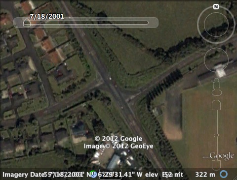
How the A26 Ballymoney Bypass / Kilraughts Road
junction looked in 2001 [Google Earth].
The scheme got underway in or around December
2004 and was opened to traffic in or around April
2005.
Map
The Google map below shows the roundabout (centre
of frame) and its hinterland as it is today:
View
Larger Map
Photos
View
Larger Map
Google
StreetView of Kilraughts Road roundabout, seen
from the south-east.
|
