|
|
Status
|
Construction scheme
(completed) |
|
Where
|
To
upgrade a dangerous junction on the A23
Ballygowan Road, near Belfast |
|
Total
Length
|
n/a |
|
Dates
|
Work began late 2000
Opened March 2001
|
|
Cost
|
£?m |
|
Photos
|
See below. |
|
See
Also
|
General
area map - Google Maps
|
The A23 Ballygowan Road is an arterial road
feeding into Belfast. It is not the busiest, but
it is busy. One of the most dangerous features of
this road was the crossroads at Manse Road / Upper
Braniel Road around a mile from the Outer Ring in
Belfast. This junction had all the classic
dangerous features:
- Located just round a blind corner on a busy
A-road.
- Located on a steep hill.
- Very poor visibility from side roads due to
vegetation, road curvature and buildings.
- Both side roads approaching the junction down
steep inclines.
A roundabout would have been the obvious
solution, but since this was not built, we can
assume that the geography of this location ruled
out such a solution. Instead, a rather deviously
clever one-way gyratory system was built. This
involved swinging citybound traffic out round a
lazy curve, and banning right-turns from the two
side roads. Traffic wishing to to turn right would
now have to turn left and then use one of two
little link roads to complete the manoeuvre. In
particular, traffic emerging from Upper Braniel
Road is forced to drive up to where there is a
clear line of sight round the corner before they
have the opportunity to turn right. This means
that no turning manoeuvre requires looking in more
than one direction, which improves safety
dramatically.
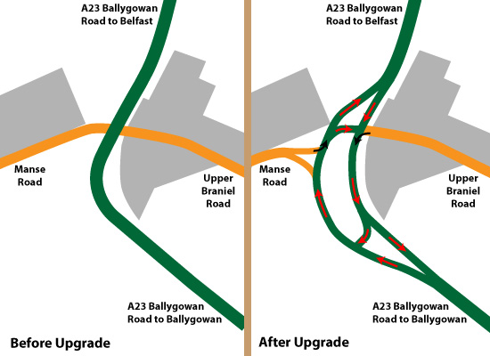
The map below shows how the junction looked
before (left) and after (right) the upgrade. The
built up area is shown in grey, the main A23 in
green and the two side roads in orange. The red
arrows indicate the one-way system, and the black
arrows indicate left-turn-only restrictions.
|