Status |
Construction scheme (completed) |
Where |
Bypasses the town of Limavady, a bottleneck on the A2 Coleraine to Londonderry road. |
Total Length |
3.6km / 2.3 miles |
Dates |
Work began December 2001
Open to traffic 4 July 2003
Officially opened 24 September 2003 |
Cost |
£11.5 million |
Photos |
See below for photos. |
See Also |
General area map - Google Maps
Roads Service site on scheme (includes many photos) |
One of Northern Ireland's longest-running road plans, the Limavady bypass was originally planned in the 1960s, as part of the M23 Ballymoney to Londonderry motorway which was never built. A downgraded plan for a trunk road on the route of the M23 in the 1970s was also never built, as were plans for an even more limited bypass in the 1980s. As traffic levels in Limavady town centre continued to rise (18,000 vehicles per day in 2001), a route was again proposed in 1991, and a Direction Order signed in 1994. However, it was not until December 2001 that work began and the bypass officially opened to traffic on 24 September 2003, 3 months behind schedule.
The route chosen was to the north of the town centre, bringing it very close to the River Roe. This was a sensitive environmental area, and archaeology was also discovered during construction.
Photos
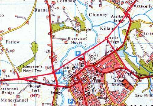
The route of the Limavady Bypass [picture from Roads Service web site].
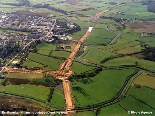
The Limavady Bypass under construction, looking west with the River Roe visible [picture by Rivers Agency, from Roads Service web site].
Roads Service have also placed lots of photographs of the scheme on their web site here.
|
